
Gravenstafel
First World War
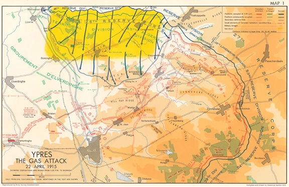
Map of the Ypres Gas Attack, 1915. Depicts the creation of a front created along the left flank of the 1st Canadian Division, CEF
Credit: Map from Nicholson, CEF 1914-1919 p. 66.
Date
22-23 April 1915
Geographical parameters
The Comines — Ypres Canal as far as Voormezeele: then road to Vlamertinghe Château — Elverdinghe Château — Boesinghe — Langemarck
Context
A battle honour incorporating the tactical incident “The Gas Attack”, formally entitled the “Battle of Gravenstafel Ridge”, and itself being part of “The Battles of Ypres, 1915”.Footnote 1
Description
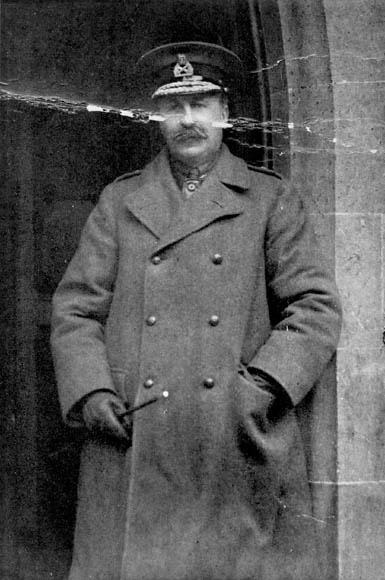
Lieutenant-General Edwin Alfred Hervey Alderson (1859-1927), commander First Canadian Division (1914-15), commander Canadian Army Corps (1915-16), inspector-general, Canadian forces (1916-18). Location unknown. 1915.
Credit: Library and Archives Canada/C-49485 (MIKAN no. 3212819)
The Honour “Gravenstafel” was awarded to Canadian units for their actions defending against a German attack, launched primarily against neighbouring French Divisions, using gas. In the late afternoon of 22 April 1915, the French colonial troops occupying the front line on the left flank of the 1st Canadian Division (Lieutenant-General E.A.H Alderson) came under an intense bombardment from German guns that then shifted to the Canadian sector. Canadian troops observed a greenish cloud of gas over the area occupied by the French troops. Subjected to chlorine gas, the French troops were forced to abandon their positions exposing the left flank of the Canadian Division. In the hours that followed, the Canadian Division fought to preserve its left flank and to prevent further penetrations from the German attack.
Units, located on the far left flank of the Canadian sector rushed reserve companies forward from the village of St-Julien to fill in the gap on their left flank. However, this still left a gap of over one and a half kilometres north of the village covered only by a battery of Canadian Field Artillery near Keerselaere. A large gap of over two kilometres existed south of St-Julien toward Wieltje, leaving a British artillery battery exposed without support in the area of Kitcheners Wood located west of St-Julien. Troops in the area and an Engineer Company were put into action to hold the area while battalions from the reserve were ordered forward to fill in the gap in the line. As the line stabilized, a counter attack on Kitchener's Wood was planned for the night of 22/23 April by the 10th and 16th Battalion and Bombers (i.e. soldiers equipped with the hand grenade of the period) from the 2nd and 3rd Brigade. Unable to hold the woods the British guns and ammunition were destroyed and both battalions retired to a defensive position south of Kitchener's Wood. Of the 1500 soldiers of both battalions that launched the attack only 500 survivors remained to take up the defence. For their heroic actions in this counter-attack during the Battle of Gravenstafel these two battalions were granted the distinction of an Oak Leaf badge.
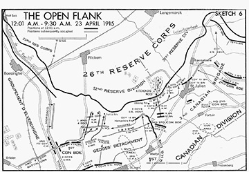
Sketch of the Open Flank, following the retreat of French colonial forces at the Second Battle of Ypres, 1915.
Credit: Sketch by Nicholson, found in C.E.F. 1914-1919 p.65.
During that night, several other Canadian and British battalions reinforced the line. Counter-attacks in the area south of Kitchener's Wood were largely unsuccessful due to a lack of coordination and resulted in heavy casualties. By early morning, they were digging-in along roughly established defensive lines. Further counter-attacks throughout the day on 23 April were also unsuccessful. The quick action of several battalions filling in gaps in their flank and the Canadian and British counter-attacks had stopped any further German advance in this area.Footnote 2
Awarded to:
Currently serving units
- 48th Highlanders of Canada
Awards to the 15th Canadian Infantry Battalion, CEF (GO 110/29) and The 48th Regiment (Highlanders) (GO 110/29) - 56th Field Artillery Regiment, RCA
Awards to the 4th Canadian Infantry Battalion, CEF (GO 110/29) and The Dufferin Rifles of Canada (GO 110/29) - The Black Watch (Royal Highland Regiment) of Canada
Awards to the 13th Canadian Infantry Battalion, CEF (GO 110/29) and The Royal Highlanders of Canada (GO 110/29) - The British Columbia Regiment (Duke of Connaught's Own)
Awards to the 7th Canadian Infantry Battalion, CEF (GO 71/30) and the 1st British Columbia Regiment (Duke of Connaught’s Own) (GO 110/29) - The Calgary Highlanders
Awards to the 10th Canadian Infantry Battalion, CEF (GO 123/29) and The Calgary Highlanders (GO 110/29) - The Canadian Scottish Regiment (Princess Mary's)
Awards to the 16th Canadian Infantry Battalion, CEF (GO 110/29) and The Canadian Scottish Regiment (GO 110/29) - Governor General's Foot Guards
Awards to the 2nd Canadian Infantry Battalion, CEF (GO 123/29) and The Governor General’s Foot Guards (GO 32/32) - The North Saskatchewan Regiment
Awards to the 5th Canadian Infantry Battalion, CEF (GO 110/29) and The Saskatoon Light Infantry (GO 110/29) - The Queen's Own Rifles of Canada
Awards to the 3rd Canadian Infantry Battalion, CEF (GO 110/29) and The Queen’s Own Rifles of Canada (GO 110/29) - The Royal Canadian Regiment
Awards to the 1st Canadian Infantry Battalion, CEF (GO 123/29) and The Canadian Fusiliers (City of London Regiment) (GO 110/29) - The Royal Hamilton Light Infantry (Wentworth Regiment)
Awards to the 4th Canadian Infantry Battalion, CEF (GO 110/29) and The Royal Hamilton Light Infantry (GO 110/29) - The Royal Montreal Regiment
- Awards to the 14th Canadian Infantry Battalion, CEF (GO 110/29) and The Royal Montreal Regiment (GO 110/29)
- The Royal Regiment of Canada
Awards to the 3rd Canadian Infantry Battalion, CEF (GO 110/29) and The Toronto Regiment (GO 110/29) - The Royal Winnipeg Rifles
Awards to the 8th Canadian Infantry Battalion, CEF (GO 110/29), the 10th Canadian Infantry Battalion, CEF (GO 123/29), The Winnipeg Light Infantry (GO 110/29), and The Winnipeg Rifles (GO 110/29) - The South Alberta Light Horse
Award to the 19th Alberta Dragoons (GO 71/30)
Units on the Supplementary Order of Battle
- 50th Field Artillery Regiment (The Prince of Wales' Rangers), RCA
Awards to the 2nd Canadian Infantry Battalion, CEF (GO 123/29) and The Peterborough Rangers (GO 110/29)
Page details
- Date modified: