
Geospatial environmental, social and governance rating tool
Disruptions to the global supply chains of critical raw materials have the potential to delay the renewable energy transition or increase its cost. While geological scarcity is often considered a primary risk, many supply chain interruptions are driven by environmental, social, and governance (ESG) factors. Areas with higher spatially situated risks are more susceptible to conflicts, protests, or policy changes that can delay, increase costs or even cancel projects.
Understanding and modelling these spatially situated risks can help interest holders prioritize areas of interest early in the exploration cycle, strengthening supply chains and encouraging responsible resource development.
To help mitigate these disruptions and support the advancement of mining projects, Canada has funded the development of a geospatial ESG rating tool under its Critical Minerals Geoscience and Data (CMGD) Initiative.
How to use the ESG rating tool
This tool uses an API (version 1.0) to provide ESG ratings for one or more pairs of geographical coordinates. To use this tool:

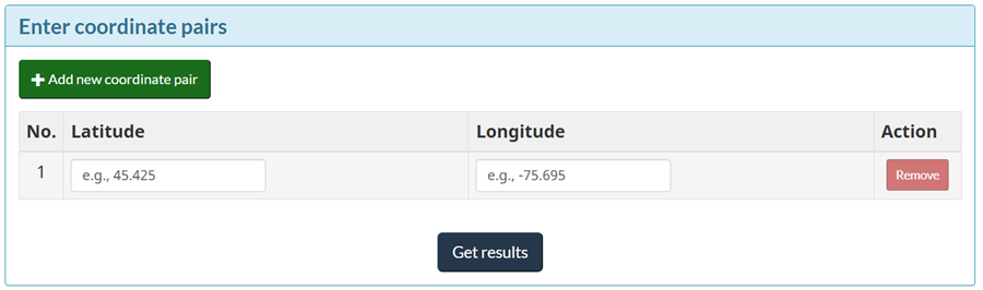
Enter coordinates
Enter a single pair of coordinates in the Latitude and Longitude fields and select Get results.
Coordinates must follow the proper format, including 3 decimal places (e.g., 45.425 or –75.965), or an error message indicated by a red exclamation icon will be sent to you.

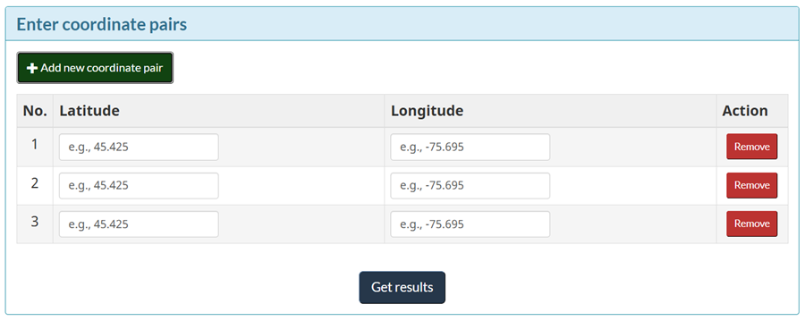
Add multiple coordinates
For multiple pairs of coordinates, select Add new coordinate pair to add as many additional rows as needed, then select Get results.
If you need to remove any of the rows of coordinates, select Remove to the right of the row you would like to remove.

Get results
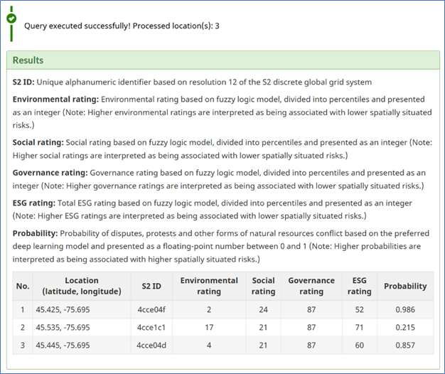
ESG rating results will appear in the Results table below.
For developers interested in programmatic access, we have prepared a comprehensive demo notebook showcasing application programming interface (API) integration examples. The notebook is available in our GitHub repository: https://github.com/NRCan/Geospatial_ESG_Model
Troubleshooting
- If you encounter an error with the Geospatial ESG Model API, check that your latitude and longitude coordinates follow the proper input format (e.g., 45.425 or –75.965).
- For unresolved issues, contact the CMGD Initiative team, at cmgd-gdmc@nrcan-rncan.gc.ca, for technical support. Include issue details, like the error code and your input coordinates for faster assistance.
About the geospatial ESG rating tool
The geospatial ESG rating tool integrates publicly available global research datasets spanning from 1996 to 2023 – covering conservation, biodiversity, freshwater stress, carbon storage, energy use, waste management, land use, human development indices, health and safety statistics, and governance indicators. By incorporating these multi-decade datasets into a predictive framework that combines fuzzy logic with deep learning, the tool generates consistent and reproducible ESG scores at the global level, providing a robust foundation for research, policy analysis, and risk assessment. The goal is to identify locations with potentially lower ESG-related risks to critical raw material supply chains.
The rating tool generates ratings across 4 components:
- Environmental
- Social
- Governance
- Total ESG rating
These ratings are reported as global percentiles (0 representing a high ESG score and 100 representing a low ESG score). Each ESG rating is associated with an uncertainty value that is based on the standard deviation of the input datasets within each model cell. Areas with higher ESG ratings are associated with lower spatially situated risks. Outputs from the deep learning model predict the probability of natural resources conflicts based on the training labels included within the POLitical Event Classification, Attributes, and Types (POLECAT) datasets.

For more information: To learn more about the Geospatial ESG Model research project and methodology, visit the full report – Geospatial Data and Deep Learning Expose ESG Risks to Critical Raw Materials Supply: The Case of Lithium.
Disclaimer: The data and information presented herein are derived from sources provided by the Government of Canada. This content is provided “as is” without warranties of any kind. The Government of Canada assumes no responsibility for the accuracy, reliability, or completeness of the data, nor for any consequences resulting from your use or interpretations of it. Users are advised to review primary data sources and independently verify results.
Publisher – Organization Name: Natural Resources Canada
Licence: Open Government Licence – Canada