
Manitoba's provincial symbols
One of Canada’s Prairie Provinces, Manitoba’s southern and western regions are predominantly grassland. Its eastern and northern regions are dominated by Canadian Shield lakes and forests. A small area of Manitoba’s extreme north is arctic tundra.
Origin of the name
The name “Manitoba” likely comes from the Cree "Man-into-wahpaow", which means "the narrows of the Great Spirit". The words describe Lake Manitoba, which narrows to half a mile at its centre. The waves on the loose surface rocks of its north shore produce curious, bell-like wailing sounds, which the First Nations believed came from a huge drum beaten by the spirit Manitou. The name “Manitoba” was given to the province at its creation in 1870 at the suggestion of Métis leader Louis Riel.
Population (2006): 1,177,800
Area: Land – 548,360 km2Fresh water – 101,590 km2Total – 649,950 km2Capital: WinnipegDate of entry into Confederation: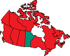
History
The Assiniboine inhabited what is now present-day Manitoba before the arrival of European explorers. Other nations included the nomadic Cree, who followed the herds of buffalo and caribou on their seasonal migrations.
In their search for the spice-rich Orient through the Northwest Passage, Europeans reached Manitoba through Hudson Bay in the early 17th century. Unlike most of the rest of Canada, the northern parts of the province were settled before the south. In 1612, British captain Thomas Button wintered two ships at Port Nelson on Hudson Bay, near the mouths of the Nelson and Hayes Rivers. In 1690 and 1691, Henry Kelsey of the Hudson’s Bay Company explored Northern Manitoba from Hudson Bay as far as the Saskatchewan River, near The Pas. A party led by French fur trader and explorer La Vérendrye travelled the Red and Winnipeg Rivers from 1733 to 1738, building several outposts.
In 1670, King Charles II of England granted the Hudson’s Bay Company a large portion of land named Rupert’s Land. The company set up fur trading posts to exploit the country’s wealth. Among their major posts were York Factory at the mouths of the Nelson and Hayes Rivers, and Prince of Wales’s Fort at the mouth of the Churchill River. The latter was a large stone fort, built between 1731 and 1771. It was captured and badly damaged by the French in 1782. The Hudson’s Bay Company then built Fort Churchill in 1783 and continued to use the site until 1933.
After 1740, in the wake of La Vérendrye, traders from New France pushed across the southern part of Manitoba. They were succeeded by teams of English-speaking “pedlars” and French-Canadian voyageurs who paddled swift canoes from Montréal to the west and back, seeking furs.
Intense rivalry for furs developed between the Montréal-based North West Company and the Hudson’s Bay Company. Their battle for the fur trade resulted in both companies building forts throughout the plains. Alexander Mackenzie, an employee of the North West Company, pushed the chain of forts west into the Rocky Mountains and north to the Arctic. The rivalry came to its height in the Red River and Assiniboine River Valleys in Manitoba, where open warfare broke out.
During the same period, the first European agricultural settlement was established by Lord Selkirk, a Scottish nobleman, who sent a number of dispossessed Scottish Highlanders to settle land he had secured from the Hudson’s Bay Company in 1811. He called the area Assiniboia.
It was not long before the Selkirk colony was caught in the fur trade war. In 1816, Governor Robert Semple and 19 colonists were killed at Seven Oaks in a battle with the Métis, who had been endorsed by the North West Company. The settlement survived; however, the violence and lengthy legal battles brought about Selkirk’s settlers and the bankruptcy of the North West Company.
In the 1860s, the Province of Canada, anxious to expand into the great northwest, asked Britain to buy out the Hudson’s Bay Company, as it had the East India Company. Although willing to request the surrender of the land from the Hudson’s Bay Company, Britain insisted that the money come from Canada. Canada offered the company 300,000 pounds sterling. The company settled for the money, plus one-twentieth of all the fertile land in the west and the land that surrounded their trading posts.
The inhabitants of the area were not consulted on this transaction. This, and the constant threat of an American invasion from the south, made them nervous. No clear terms were spelled out for the people of the Red River area and, during negotiations on their status, resistance developed in the colony. The Métis, a mostly French-speaking people of mixed European and Aboriginal ancestry, rallied under the leadership of Louis Riel to oppose the Canadian proposals. Riel succeeded in uniting both the French- and English-speaking groups to establish a locally elected, provisional government in 1869.
Negotiations between the provisional government and the government of Canada led to Parliament passing the Manitoba Act, 1870, under which Manitoba joined the other provinces in Confederation.
The new province consisted of 36,000 square kilometres surrounding the Red River Valley. It was called the “postage stamp” province because of its square shape and relatively small size. However, the province did not remain that small. Its boundaries were enlarged in 1881 and again in 1912. Today, Manitoba is 650,000 square kilometres and could have been larger had it not been for an 1884 decision in favour of Ontario, which established the present-day boundary between the two provinces.
Agricultural settlement helped the province prosper in its infancy. With the help of the railway and certain acts of Parliament in the late 1800s, the province was soon filled with settlers from Eastern Canada and Europe.

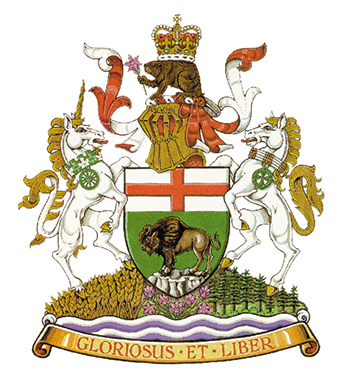
Coat of arms
Royal warrant for Manitoba’s shield was granted by King Edward VII in 1905, while its augmented coat of arms was granted by the Right Honourable Ramon J. Hnatyshyn, Governor General in 1992.
At the centre of the arms is the original shield, featuring the Cross of St. George and a buffalo standing on a rock. Above the shield is a gold helmet signalling Manitoba’s co-sovereign status in Confederation. On top is a beaver, a national symbol of Canada, holding the province’s floral emblem (prairie crocus) and carrying a royal crown on its back.
The shield supporters are a unicorn, reflecting the province’s early Scottish settlers, and a white horse, an animal vital to the First Peoples, the Métis and European settlers. The unicorn and the horse stand atop waters, grain fields and forests. The seven provincial flowers at the centre represent one people of diverse origins.
Motto
Gloriosus et liber (Glorious and free)
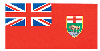
Flag
Approval to use the Royal Union Flag in the design of Manitoba’s provincial flag was given by Queen Elizabeth II in 1965.
The flag closely resembles the Canadian Red Ensign. The Royal Union Flag occupies the upper quarter on the staff side, while the provincial shield is centred on the fly half of the flag. The flag’s proportions are two by length and one by width.
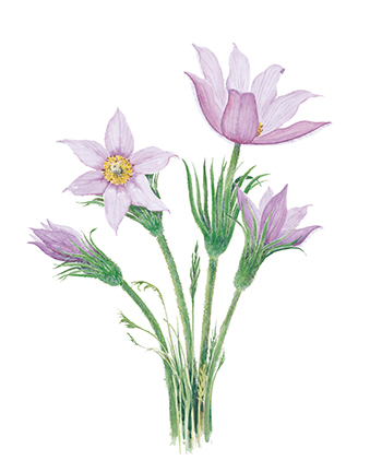
Floral emblem
The prairie crocus (Pulsatilla ludoviciana) was adopted as Manitoba's floral emblem in 1906.
Manitoba was the first of the Prairie Provinces to adopt a floral emblem after the prairie crocus was chosen in an informal vote in the province’s schools. An early spring flower, the prairie crocus is often seen pushing through the last prairie snow. The flower, which ranges from light lavender to bluish purple in colour, has an outer coating of hair to protect it from sudden changes in temperature.
Other provincial symbols
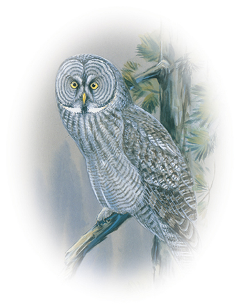
Bird
Adopted as Manitoba’s official bird in 1987, the great gray owl (Strix nebulosa) is the largest owl in North America with a wingspan of 1.3 metres (4 feet). It can be found across the province year round.
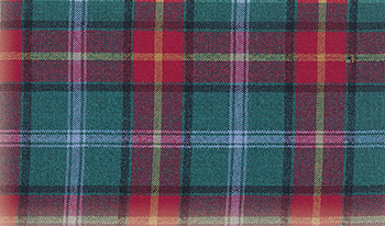
Tartan
The Manitoba tartan, designed by Hugh Kirkwood Rankine was registered at the Court of the Lord Lyon, King of Arms of Scotland, and given royal assent in 1962. The red squares represent the Red River Settlement; the green squares signify the natural resources of the province; the azure blue squares represent Lord Selkirk, founder of the Red River Settlement; the dark green lines represent the people of different cultures and races who have enriched the life of the province; and the golden lines signify the grain and other agricultural products of Manitoba.
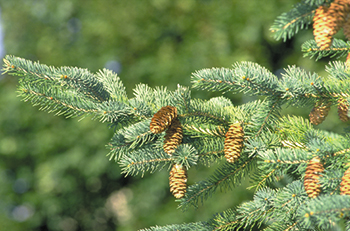
Tree
The white spruce (Picea glauca) is capable of surviving in virtually every climatic and environmental region of Manitoba. Best known as a traditional Christmas tree, the white spruce is often cultivated for this purpose.

Page details
- Date modified: