St. Lawrence River: changes in the wetlands
Lake Saint-Pierre has the largest surface area of marshes and swamps in the entire St. Lawrence basin and exhibits a remarkable diversity of wetlands. This region was also designated as a Ramsar Site in 1998 under the Convention on Wetlands of International Importance, and as a Biosphere Reserve in 2001.

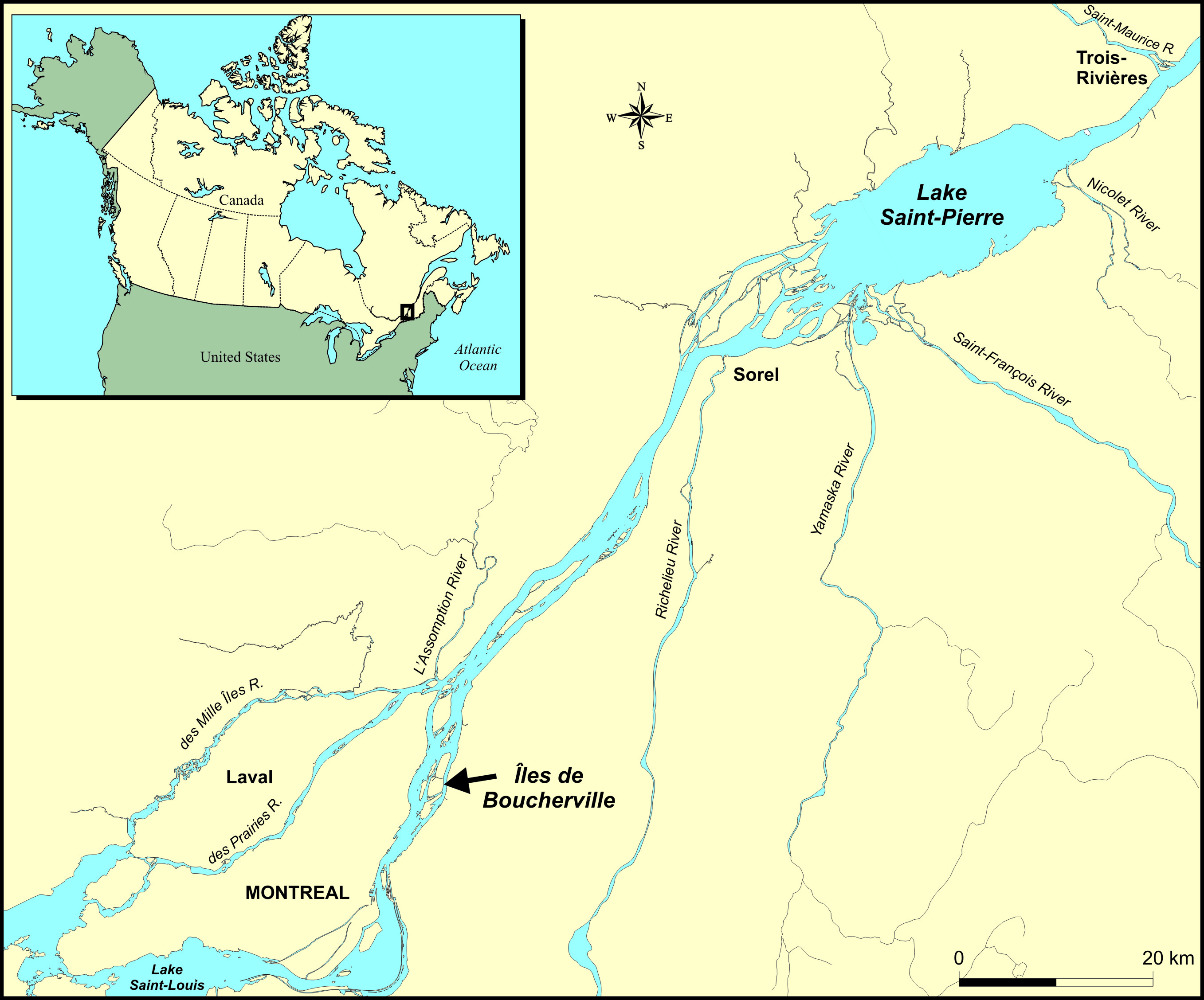
Fluvial sector of the St. Lawrence River
Map illustrating Canada and the United States in mortise with a zoom on the fluvial sector of the St. Lawrence river between Montreal and Trois-Rivières, including the Boucherville Islands.
Did you know? The wetlands of the St. Lawrence are valuable because they perform essential ecological functions. They act as natural water purification systems. Characterized by remarkable biodiversity, they supply wildlife with food and provide buffers against shoreline erosion.
Agriculture is still encroaching on the wetlands of Lake Saint-Pierre
The wetlands of Lake Saint-Pierre are exposed to agricultural pressures. According to scientific studies conducted by Environment and Climate Change Canada, it is estimated that 76% of the perimeter of these wetlands is no longer protected by a natural buffer zone, i.e., a greenbelt at least 50 metres wide.

Absence (red) and presence (green) of buffer zone in wetlands at the mouth of the Yamaska river in lake Saint-Pierre in 2010
Map illustrating the mouth of the Yamaska river in lake Saint-Pierre where red lines indicate the absence of buffer zone around the wetlands and green lines indicate their presence.
The lack of a buffer zone makes wetlands vulnerable to agricultural encroachment. This is demonstrated by the fact that 826 hectares of wetlands, or the equivalent of 600 soccer fields, in Lake Saint-Pierre have been lost to agriculture since 1990.

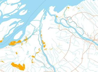
Wetlands that have been converted to agricultural use between 1990 and 2010 at the mouth of the Yamaska river in lake Saint-Pierre
Map illustrating the mouth of Yamaska river at lake Saint-Pierre where yellow areas indicate the disappearance of wetlands for the benefit of agriculture between 1990 and 2010.
The loss of wetlands in the St. Lawrence Valley is not a recent phenomenon
At the beginning of the colonial period, the area occupied by wetlands in the greater Montreal area was five times larger than it is today. From the 1940s to the 1970s, the pace at which wetlands near urban centres disappeared continued to accelerate.
According to Martin Jean of Environment and Climate Change Canada, who specializes in monitoring the wetlands of the St. Lawrence, “The dynamics of these wetlands are complex; they disappear in certain locations and appear elsewhere as part of a normal process. Their surface area has been relatively stable for about 40 years. However, wetlands are undergoing significant internal changes.”
Did you know? The succession of wetland plants along a moisture gradient from water to dry land is called the hydrosere. It includes a diversity of wetlands ranging from aquatic grass beds in shallow water to forested swamp.

Hydrosere
Hydrosere showing different types of wetlands from water to dry land such as aquatic grass bed, low marsh, high marsh, shrub swamp and forested swamp.
Conversion from low marshes to high marshes
The Parc national des Îles-de-Boucherville [Boucherville Islands provincial park] located near Montreal, has benefited from protection status since 1984. This initiative has helped to maintain the diversity and richness of the wetlands by protecting them from human pressures. Three-quarters of the perimeter of the park’s wetlands is protected by buffer zones.

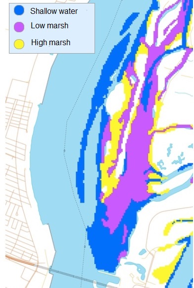
1970

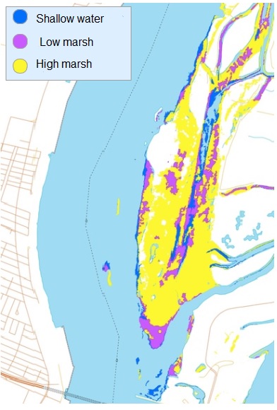
2010
Changes in wetlands between 1970 and 2010
Map of Boucherville Islands showing different type of wetlands in 1970 an 2010, such as shallow water in blue, low march in pink and high marsh in yellow. Low marshes dominate in 1970 while in 2010, they are high marshes.

Four times fewer aquatic grass beds in 2010 than in 2002
Aquatic grass beds (blue), which are found in shallow water, accounted for only 10% of wetlands in Boucherville Islands park in 2010. Their surface area was four times larger in 2002. These environments provide critical habitat for many plant (water lily, water milfoil, pondweed, etc.) and wildlife species (invertebrates, amphibians, fish, birds, etc.). Yellow Perch and Northern Pike spawn in these areas. The disappearance or conversion of these environments can have impacts on the ecological functions of the St. Lawrence ecosystem.
“These changes may not be permanent since they are potentially associated with fluctuations in water levels. The low water levels of the St. Lawrence in 2010 may have caused the disappearance of submerged vegetation, characteristic of aquatic grass beds, replaced by open water, free of vegetation. Monitoring of the wetlands in the Boucherville Islands park is still required in order to understand how they are affected by changes over time,” points out Martin Jean.
Did you know?
Invasive plant species are harmful species whose introduction or spread threatens the environment, the economy or society, including human health. They may be native, when they grow naturally in an environment without human intervention, or alien, when they were introduced into an environment outside their natural range by human intervention.
Conservation and restoration initiatives
The general state of the wetlands in these sectors is considered relatively good despite the concerns raised by the changes that they are undergoing. The designation of the Boucherville Islands as a provincial park ensures them some measure of protection. Wetland conservation and restoration projects have been carried out in Lake Saint-Pierre by various organizations, including the Société d’aménagement de la Baie Lavallière, the Société d’aménagement récréatif pour la conservation de l’environnement du lac Saint-Pierre, the Nature Conservancy of Canada and Ducks Unlimited Canada, and by the Canadian Wildlife Service.
The National Wetland Conservation Fund supports wetland conservation and restoration projects that aim to
- restore degraded or lost wetlands;
- enhance degraded wetlands;
- scientifically assess and monitor the health and functioning of wetlands and of the species that use them;
- encourage stewardship and enjoyment of wetlands by a wide range of partners in order to promote support for future wetland conservation and restoration activities (Environment Canada, website accessed November 2014).
Environment and Climate Change Canada is continuing its efforts to monitor the freshwater wetlands of the St. Lawrence, including assessments of their status and changes over time. To this end, scientists are developing and using environmental indicators in order to provide accurate, reliable and useful data. The findings of these studies are helping to increase our understanding of the dynamics of these ecosystems and may contribute to the understanding of emerging issues such as the proliferation of harmful algae.
References
Working Group on the State of the St. Lawrence Monitoring. 2014. Overview of the State of the St. Lawrence 2014. St. Lawrence Action Plan. Environment Canada, Ministère du Développement durable, de l’Environnement et de la Lutte contre les changements climatiques du Québec, Ministère des Forêts, de la Faune et des Parcs du Québec, Parks Canada, Fisheries and Oceans Canada, and Stratégies Saint-Laurent, 52 p.
State of the St. Lawrence Monitoring Committee. 2008. Overview of the State of the St. Lawrence River 2008. St. Lawrence Plan. Environment Canada, Ministère du Développement durable, de l’Environnement et des Parcs du Québec, Ministère des Ressources naturelles et de la Faune du Québec, Fisheries and Oceans Canada, and Stratégies Saint-Laurent. 28 pages.
Jean, M., and G. Létourneau. 2014. Freshwater Wetlands, 3rd edition. Environment Canada, Science and Technology Branch, Water Quality Monitoring. Monitoring sheet in the “Monitoring of the State of the St. Lawrence” series.
Jean, M., and G. Létourneau. 2011. Changes to the wetlands of the St. Lawrence River from 1970 to 2002. Environment Canada, Science and Technology Branch, Quebec Water Quality Monitoring and Surveillance Section, Technical Report Number 511, 293 pages.
Savage, C., and M. Jean. 2008. Invasive Plant Species of the St. Lawrence Wetlands. Environment Canada - Quebec Region and Ministère du Développement durable, de l’Environnement et des Parcs du Québec. Monitoring sheet in the “Monitoring of the State of the St. Lawrence” series.
Links
Open Government - Field data for the mapping of the Lake St. Pierre wetlands (St. Lawrence River), 2012
Open Government - Field data for the mapping of the Boucherville Islands sector’s wetlands (St. Lawrence River), 2012
Open Government - Field data for the mapping of wetlands in the St. Lawrence River between Cornwall and Trois-Pistoles, 2000-2001
Environment and Climate Change Canada - Wetlands
Environment and Climate Change Canada - National Wetland Conservation Fund