Historical boundaries of Canada
The following maps provide a picture of Canada’s territorial evolution, from 1840 to 1999.
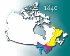
1840
The Act of Union, passed in July 1840 and proclaimed February 10, 1841, abolished the legislatures of Lower Canada and Upper Canada. It established a new political entity, the Province of Canada, to replace them.
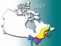
1867
The new Dominion of Canada is no larger than Nova Scotia, New Brunswick, and the land near the Gulf of St. Lawrence, the St. Lawrence River and the north side of the Great Lakes.
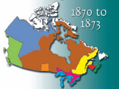
1870 to 1873
1870 – The British government transfers control of the North-Western Territory to Canada. The Hudson’s Bay Company sells Rupert’s Land to the new nation. The Province of Manitoba is created out of this vast area. The new province, made up of land around the Red River, is small by Canadian standards – 36,000 km². The rest of the newly acquired land is called the Northwest Territories.
1871 – The colony of British Columbia becomes a province of Canada.
1873 – The small island colony of Prince Edward Island, which had rejected Confederation six years earlier, joins the union.
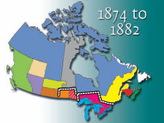
1874 to 1882
1874 – Boundaries for the Province of Ontario are expanded.
1876 – The District of Keewatin is created from part of the Northwest Territories.
1880 – Britain transfers ownership of the islands of the Arctic Archipelago to Canada.
1881 – Manitoba’s boundaries are extended for the first time. The new area added to Manitoba was part of the area given to Ontario in 1874. This causes conflict between Manitoba and her neighbouring province.
1882 – The districts of Assiniboia, Saskatchewan, Alberta and Athabaska are formed in the Northwest Territories.
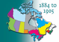
1884 to 1905
1889 – The boundary dispute between Manitoba and Ontario is settled in Ontario’s favour. Ontario’s borders are enlarged northward.
1895 – The districts of Ungava, Franklin, Mackenzie and Yukon are created in the Northwest Territories.
1898 – Quebec’s boundaries are extended northward; the District of Keewatin is enlarged and the District of Yukon becomes a separate territory.
1903 – A boundary dispute between British Columbia and Alaska is settled.
1905 – The provinces of Alberta and Saskatchewan are created out of the districts of Athabaska, Alberta, Saskatchewan and Assiniboia; the District of Keewatin is transferred to the newly defined Northwest Territories.
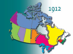
1912
The boundaries of Quebec, Ontario and Manitoba are extended northward to Hudson Bay and the Hudson Strait.
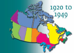
1920 to 1949
1920 – Boundaries are established among the districts of the Northwest Territories.
1927 – The Quebec-Labrador boundary is defined by the Judicial Committee of the British Privy Council.
1949 – Newfoundland joins Confederation, becoming Canada’s tenth province.
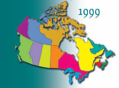
1999
The Northwest Territories are divided to create Nunavut, Canada’s newest territory, in the Eastern Arctic.