
Bird Conservation Strategy for region 12 in Quebec
- Abridged version -
May 2013

The abridged version of the strategy available here contains a summary of the results, but does not include an analysis of conservation needs by habitat, a discussion of widespread conservation issues, or the identification of research and monitoring needs.
Other formats available for this document:
Table of contents
Preface
Environment and Climate Change Canada (ECCC) led the development of all-bird conservation strategies in each of Canada's Bird Conservation Regions (BCRs) by drafting new strategies and integrating new and existing strategies into an all-bird framework. These integrated all-bird conservation strategies will serve as a basis for implementing bird conservation across Canada, and will also guide Canadian support for conservation work in other countries important to Canada's migrant birds. Input to the strategies from Environment and Climate Change Canada's conservation partners is as essential as their collaboration in implementing their recommendations.
Environment and Climate Change Canada has developed national standards for strategies to ensure consistency of approach across BCRs. Bird Conservation Strategies will provide the context from which specific implementation plans can be developed for each BCR, building on the programs currently in place through Joint Ventures or other partnerships. Landowners including Aboriginal peoples will be consulted prior to implementation.
Conservation objectives and recommended actions from the conservation strategies will be used as the biological basis to develop guidelines and beneficial management practices that support compliance with regulations under the Migratory Birds Convention Act, 1994.
Acknowledgements
Véronique Connolly, Stéphane Légaré, Benoît Audet and François Fournier were the main authors of this document. This strategy follows templates developed by Alaine Camfield, Judith Kennedy and Elsie Krebs with the help of the BCR planners in each of the Canadian Wildlife Service regions throughout Canada. However, work of this scope cannot be accomplished without the contribution of other colleagues who provided or validated technical information, commented on earlier draft versions of the strategy, and supported the planning process. We would like to thank the following people: Matthieu Allard, Yves Aubry, Luc Bélanger, Martine Benoît, Daniel Bordage, Pierre Brousseau, Vincent Carignan, Richard Cotter, Marie-France Dalcourt, Emmanuel Dalpé-Charron, Bruno Drolet, Gilles Falardeau, Patricia Houle, Benoît Jobin, Sandra Labrecque, Claudie Latendresse, Josée Lefebvre, Christine Lepage, Jean-François Rail and François Shaffer.
Bird Conservation Strategy for Bird Conservation Region 12 in Quebec: Boreal Hardwood Transition
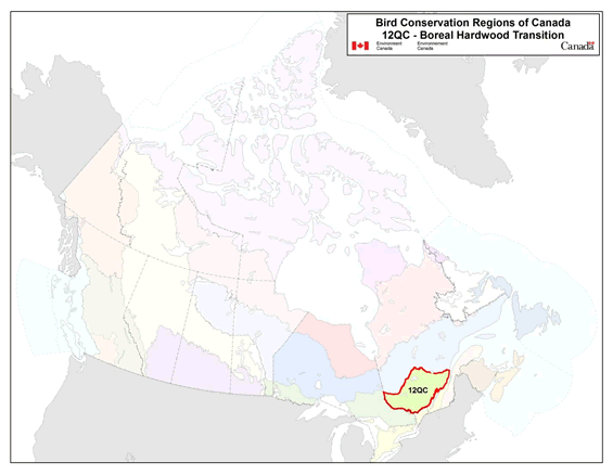
Long Description for the map
Map of the Bird Conservation Regions (BCRs) of Canada with BCR 12, Quebec Region: Boreal Forest Transition highlighted. Canada (with Alaska, Greenland and the northern portion of the United States of America also appearing) is shown very washed out, as it is only present to provide context for the location of the highlighted BCR 12. The washed out Canadian map is divided by BCR (12 Canadian BCRs in total), differently, and their exact locations and sizes are indistinguishable, aside from BCR 12.
The highlighted BCR 12 covers the southern portion of Quebec, from the Ottawa and St-Lawrence rivers in the south, to about half way up the northern coast of the St-Lawrence in the east, and to about half way up the Ontario/Quebec border in the west. Its northern border is approximately (roughly) oriented SW by NE between the westernmost and easternmost points of the BCR.
The following legend appears in the top right corner of the map: “Bird Conservation Regions of Canada. 12 QC - Boreal Harwood Transition” and includes the Environment and Climate Change Canada logo, and the Government of Canada logo.
Executive summary
In Quebec, the Boreal Hardwood Transition Bird Conservation Region (BCR 12) is essentially located in the southern Laurentian ecoregion and covers 170 951 km2. Outside Quebec, BCR 12 covers the area around lakes Superior, Michigan and Huron, and the western section of the BCR straddles the Canada-U.S. border. Most of BCR 12-QC is covered with mixed wood forests and is composed of hills, plateaus and depressions, interspersed with higher massifs. There are several rivers and small lakes, as well as some large reservoir lakes that are used for generating hydroelectric power. There are few agricultural and urban areas due to the region's rugged terrain. The flora and fauna are diverse, and birdlife is chiefly represented by forest species.
Pursuant to an assessment of the 215 bird species in BCR 12-QC, 62 species were identified as priorities in this BCR. The priority list includes species from 4 bird groups: landbirds (82%), waterfowl (8%), waterbirds (7%) and shorebirds (3%). These priority species include 20 species considered at risk either federally or provincially. Priority species use 11 habitat types in BCR 12-QC, and the habitats that attract most species are the mixed wood forests (35% of priority species), wetlands (32%), deciduous forests (27%), coniferous forests (27%) and riparian areas (21%).
Each priority species was assigned a population objective based on its population trend. Maintaining populations at current levels was the objective most often selected for priority species in BCR 12-QC (35% of priority species), while “assess/maintain” was the objective assigned to 15% of the species. Better population trend data are required for the vast majority of the species that have been assigned one of these two objectives. A recovery objective was assigned to 23% of the species (all are species at risk), and population increase objectives were also assigned to 27% of the priority species, reflecting the magnitude of the threats to bird populations in this BCR.
A threat assessment identified a number of conservation issues facing priority species in the various habitats of BCR 12-QC. Major threats include habitat loss and degradation caused by forestry and agriculture, ecosystem changes such as shrub habitats transitioning to forest habitats, as well as climate change and severe weather events. The lack of biological or demographic data on the priority species, and the presence of species at risk without recovery strategies or management plans, were also considered as significant conservation issues since 76% of the species are affected. The habitats most severely affected by the threats identified in BCR 12-QC include deciduous forests, cultivated and managed areas, urban areas, and wetlands.
Conservation objectives have been established to counter threats and provide the missing information on priority species. In BCR 12-QC, conservation objectives chiefly involve providing suitable habitat for priority species, by ensuring, among other things, that resource and land use policies maintain or improve bird habitat. Another major conservation objective is to improve bird population monitoring to gather the missing ecological and demographic information for most of the priority species in the BCR.
Conservation actions have been recommended for priority species in BCR 12-QC in order to achieve established conservation objectives. The recommended actions largely relate to population monitoring and include on-the-ground activities such as increasing the coverage of the Breeding Bird Survey (BBS), conducting specific surveys, expanding the current migration monitoring program, and maintaining waterfowl banding and survey programs. A significant portion of the recommended actions involve protecting sites and, more particularly, wetlands. These actions include protecting wetlands through mechanisms such as the creation of protected areas, stewardship, the adoption of municipal urban plans that protect wetlands and woodlands, and the protection of large tracts of mature forest.
Migratory birds found in BCR 12-QC also face threats that are difficult to analyze with the standardized methodology used in this strategy. These threats include widespread issues that may sometimes not apply to a particular habitat (e.g., collisions with human-made structures, air pollution and climate change), research needs and population monitoring, as well as threats to migratory birds when they are outside Canada. An overview of these issues, the affected species and the recommended conservation actions is also presented.
Introduction: Bird Conservation Strategies
Context
This document is one of a suite of Bird Conservation Region Strategies (BCR strategies) that have been drafted by Environment and Climate Change Canada for all regions of Canada. These strategies respond to Environment and Climate Change Canada's need for integrated and clearly articulated bird conservation priorities to support the implementation of Canada's migratory birds program, both domestically and internationally. This suite of strategies builds on existing conservation plans for the four “bird groups” (waterfowl,Footnote 1waterbirds,Footnote 2shorebirds,Footnote 3and landbirdsFootnote 4) in most regions of Canada, as well as on national and continental plans, and includes birds under provincial/territorial jurisdiction. These new strategies also establish standard conservation planning methods across Canada, and fill gaps, as previous regional plans do not cover all areas of Canada or all bird groups.
These strategies present a compendium of required actions based on the general philosophy of achieving scientifically based desired population levels as promoted by the four pillar initiatives of bird conservation. Desired population levels are not necessarily the same as minimum viable or sustainable populations, but represent the state of the habitat/landscape at a time prior to recent dramatic population declines in many species from threats known and unknown. The threats identified in these strategies were compiled using currently available scientific information and expert opinion. The corresponding conservation objectives and actions will contribute to stabilizing populations at desired levels.
The BCR strategies are not highly prescriptive. In most cases, practitioners will need to consult additional information sources at local scales to provide sufficient detail to implement the recommendations of the strategies. Tools such as beneficial management practices will also be helpful in guiding implementation. Partners interested in participating in the implementation of these strategies, such as those involved in the habitat Joint Ventures established under the North American Waterfowl Management Plan (NAWMP), are familiar with the type of detailed implementation planning required to coordinate and undertake on-the-ground activities.
Strategy structure
Section 1 of this strategy, published here, presents general information about the BCR and the subregion, with an overview of the six elementsFootnote 5 that provide a summary of the state of bird conservation at the sub-regional level. Section 2, included in the full strategy, provides more detail on the threats, objectives and actions for priority species grouped by each of the broad habitat types in the subregion. Section 3, also part of the full strategy, presents additional widespread conservation issues that are not specific to a particular habitat or were not captured by the threat assessment for individual species, as well as research and monitoring needs, and threats to migratory birds while they are outside of Canada. The approach and methodology are summarized in the appendices of the full strategy, but details are available in a separate document (Kennedy et al. 2012). A national database houses all the underlying information summarized in this strategy and is available from Environment and Climate Change Canada.
Characteristics of Bird Conservation Region 12-QC
The western portion of the Boreal Hardwood Transition Bird Conservation Region (BCR 12) straddles the Canada-U.S. border and covers the area around lakes Superior, Michigan and Huron. In Quebec, BCR 12 covers 170 951 km2 and essentially corresponds to the South Laurentian ecoregion. It is located north of the St. Lawrence lowlands and extends west to the Ontario border and east to near the mouth of the Saguenay River, then north a little beyond the 49th parallel Figure 1).
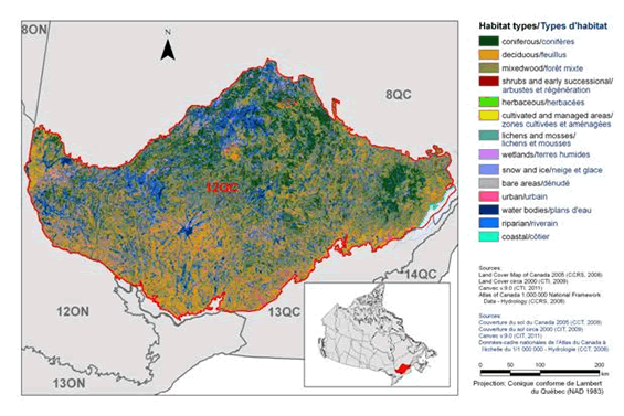
Long Description for Figure 1
Map of the landcover in BCR 12 Quebec Region: Boreal Forest Transition. The map's extent includes southern Quebec and eastern Ontario. The borders of BCR 8ON, 8QC, 12ON, 13ON, 13QC and 14 QC are delineated. Inset in the lower right corner is a map of Canada with BCR12 highlighted.
BCR 12 covers the southern portion of Quebec, from the Ottawa and St-Lawrence rivers in the south, to about half way up the northern coast of the St-Lawrence in the east, and to about half way up the Ontario/Quebec border in the west. Its northern border is approximately (roughly) oriented SW by NE between the westernmost and easternmost points of the BCR.
The various habitat types that exist in the BCR are shown on the map differently, and are explained in the following bilingual legend (appearing to the right of the map):
- Coniferous/conifères
- Deciduous/feuillus
- Mixedwood/forêt mixte
- Shrubs and early successional/arbustes et regeneration
- Herbaceous/herbacées
- Cultivated and managed areas/zone cultivées et aménagées
- Lichens and mosses/lichens et mousses
- Wetlands/terres humides
- Snow and ice/neige et glace
- Bare areas/denude
- Urban/urbain
- Water bodies/plans d'eau
- Riparian/riverain
- Coastal/côtier
Deciduous forest , primarily in the southern 2/3 of the BCR, is the most common habitat type, followed by coniferous forests in the north and waterbodies (lakes and rivers) throughout. There are several sizeable areas of wetlands patchily distributed across the BCR. There are several small urban areas along the southern border of the BCR and one notable coastal area along the north shore of the St-Lawrence River at the easternmost end of the BCR. The other habitat types occur in smaller concentrations throughout the BCR, and some are not visible at this scale.
The remaining text in the legend is the following: Sources: Land Cover Map of Canada 2005 (CCRS, 2008), Land Cover circa 2000 (CTI, 2009), Canvec v 9.0 (CTI, 2011), Atlas of Canada 1,000,000National Framework Data - Hydrology (CCRS, 2008). Sources: Couverture du sol du Canada 2005 (CCT, 2008), Couverture du sol circa 2000 (CIT, 2009), Canvec v 9.0 (CIT, 2011), Données-cadre nationales de l'Atlas du Canada à l'échelle du 1/1 000 000 - Hydrologie (CCT, 2008). There is also a visual representation of scale for the map in the legend which indicates 0, 50, 100 and 200 kms. The Projection is Conique conforme Lambert du Quebec (NAD 1983).
Physical environment
Topography
The relief of BCR 12-QC features hills, plateaus and depressions, interspersed with higher massifs (Li and Ducruc, 1999). The elevation of the massifs ranges from 600 m to over 1000 m, while the height of the rest of the area ranges from 200 m to 450 m. The highest peaks include Mont Sainte-Anne (800 m), Mont Tremblant (968 m), Mont Belle Fontaine (1151 m) and Mont Raoul Blanchard (1181 m, Natural Resources Canada, 2009).
Hydrography and hydrology
BCR 12-QC is primarily drained by two major north-south watersheds: the Ottawa River and Saint-Maurice River watersheds (Li and Ducruc, 1999). Other major rivers include the Montmorency, Jacques-Cartier, Batiscan, du Lièvre, Gatineau, Maskinongé and the Assomption. Lake density is average, and the lakes themselves are rather small, with the exception of a few large reservoir lakes exceeding 300 km2 that are used to produce hydroelectricity (for example, the Cabonga, Baskatong, Gouin, Dozois and Kipawa reservoirs; Ministère du Développement durable, de l'Environnement et des Parcs, 2002).
Climate
BCR 12-QC's climate is characterized by hot summers and cold, snowy winters. The average annual temperature is about 1.5°C, while the average summer temperature is 14°C and the mean winter temperature is −11°C. The climate is warmer along the southern border of the BCR. The average annual rainfall ranges from 800 mm in the northwest to 1000 mm near Québec. In the Laurentides Wildlife Reserve, between Québec and the Saguenay-Lac-Saint-Jean region, the range is from 1200 to 1600 mm (Ecological Stratification Working Group, 1996).
Land cover and land use
BCR 12-QC is mostly covered with mixed wood forests (Figure 1). The area contains some of the best timber reserves in Quebec (Ecological Stratification Working Group, 1996), and logging is an important activity in the region. The forest is also used extensively for hunting, trapping, recreation and tourism. BCR 12's rugged terrain is not suitable for agriculture, so there is little farming in the area. Cultivated and managed land accounts for only 0.6% of the area (Figure 1), and these are primarily in the Témiscamingue, Outaouais and Charlevoix areas. The BCR has a limited number of urban areas, most of which are concentrated in the southern part of the region, bordering the St. Lawrence lowlands (BCR 13). Wetlands account for only 2% of the land. Over half of the land occupied by BCR 12-QC is Crown land (Drolet et al. 2010).
Biological environment
Vegetation
BCR 12 includes a variety of plant communities whose range within the area depends largely on latitude and elevation. The BCR contains three subzones of vegetation that transition from the southern part of the region to the northern part as follows: hardwood forest, mixed wood forest and continuous boreal forest (Quebec's Ministère des Ressources naturelles, 2013).
The hardwood forest subzone hosts the sugar maple-basswood bioclimatic domain, characterized by diverse flora including many species at the northern limit of their range. The sugar maple is the dominant species, and other species such as the basswood, American white ash, ironwood and butternut also inhabit the area. The hardwood forest subzone also includes the sugar maple-yellow birch bioclimatic domain. The flora here is less diverse and includes several boreal species. Companion species to the sugar maple include the yellow birch, American beech, red oak and hemlock. Windfall is a key element of forest dynamics in this sub-area.
Further north, the mixed forest subzone consists of the balsam fir-yellow birch domain, which is a transition area between the deciduous and boreal forest. This domain is characterized by mixed stands of yellow birch and conifers such as balsam fir, white spruce and cedar. The main factors of forest dynamics in this sub-area are outbreaks of spruce budworm and fires.
Finally, the continuous boreal forest subzone covers the northern portion of BCR 12-QC and is represented by two bioclimatic domains: balsam fir-white birch, and spruce-moss. The balsam fir-white birch domain is characterized by fir and white spruce mixed with white birch mesic sites, while less favourable sites include black spruce, jack pine and larch, accompanied by white birch or trembling aspen. The main factors of forest dynamics in this domain are outbreaks of spruce budworm and fires. The spruce-moss domain is clearly dominated by black spruce, but there are also balsam fir and some deciduous trees such as white birch and trembling aspen. This domain is also characterized by undergrowth covered with feather mosses and ericaceous shrubs and a limited number of herbaceous species. The fire cycle is the main element of forest dynamics in this domain.
Wildlife
BCR 12-QC provides habitats where a wide diversity of animal species can feed and reproduce. Mammalian species that are abundant or representative of the area include white-tailed deer (south), moose (north), black bear, beaver, fisher, raccoon and wolf (Li and Ducruc, 1999). BCR12-QC hosts one of only two herds of woodland caribou (a species considered vulnerable in Quebec and threatened in Canada) south of the 49th parallel in Quebec. Species in BCR 12-QC likely to be designated threatened or vulnerable in Quebec include the least weasel, southern flying squirrel, eastern red bat, silver-haired bat and hoary bat (Quebec's Ministère du Développement durable, de l'Environnement, de la Faune et des Parcs, 2013a).
BCR 12-QC features a large variety of amphibians and reptiles. They include the wood turtle, Blanding's turtle and northern map turtle, which are species at risk in both Quebec and Canada (Quebec's Ministère du Développement durable, de l'Environnement, de la Faune et des Parcs, 2013a; Species at Risk Public Registry, 2012). There are also species likely to be designated threatened or vulnerable in Quebec such as the pickerel frog, northern water snake, brown snake and milksnake.
BCR 12-QC also features a diverse fish fauna. Representative fish species includes smallmouth bass, walleye, brook trout, lake trout and northern pike (Li and Ducruc, 1999). BCR 12 hosts the only spring cisco population in Canada, a salmonid species likely to be designated threatened or vulnerable in Quebec, which inhabits Lac des Écorces, near Mont-Laurier. Species of non-indigenous salmonids, such as rainbow trout and brown trout, are regularly stocked in some lakes in the BCR (Quebec's Ministère du Développement durable, de l'Environnement, de la Faune et des Parcs, 2013b).
Because forest covers most of the land occupied by BCR 12-QC, avifauna in this BCR includes a large percentage of forest species. The Ruffed Grouse, Broad-winged Hawk, Yellow-bellied Sapsucker, Wood Thrush, American Redstart Warbler and Black-throated Blue Warbler are among the wide variety of species that are characteristic of deciduous or mixed wood forests. In forests dominated by conifers, representative species include the Spruce Grouse, Black-backed Woodpecker, Bicknell's Thrush, Cape May Warbler and the Blackpool Warbler. The few farming communities in BCR12-QC are inhabited by rural species such as the Bobolink, Eastern Meadowlark, Horned Lark, Savannah Sparrow and Vesper Sparrow. Representative species of aquatic and wetland areas in BCR 12-QC include the Common Loon, American Bittern, Great Blue Heron, Pied-billed Grebe, American Black Duck, Common Goldeneye, Wood Duck and Ring-necked Duck. BCR 12-QC includes species who have a limited range within Quebec, such as the Golden-winged Warbler and Nelson's Sharp-tailed Sparrow.
Human environment
Local communities
Approximately 639 000 people live in BCR 12-QC, which represents 8% of the population of Quebec (adapted from Statistics Canada, 2012). The main population centres are Saint-Jérôme (68 456), Mont-Laurier (13 779) and La Tuque (11 227). There are 11 Aboriginal communities with an approximate total population of 9 500 in BCR 12-QC, living in 6 of the 8 administrative regions of Quebec included in the BCR (Aboriginal Affairs and Northern Development Canada, 2010). The 2 largest Aboriginal communities are the Atikamekw villages of Opitciwan and Manawan, each of which have nearly 2100 inhabitants.
Protected areas
Approximately 6% of the land in BCR 12-QC has protected area status (Figure 2). Four Quebec national parks (responsibility of Quebec's Ministère du Développement durable, de l'Environnement, de la Faune et des Parcs) and a national park (operated by Parks Canada) are entirely located with the BCR. The parks cover a total area of 3251 km2. They are the Jacques-Cartier, Grands-Jardins, Hautes-Gorges-de-la-rivière-Malbaie and Mont-Tremblant national parks of Quebec and the La Mauricie National Park of Canada. In addition, the BCR includes about 96% of Gatineau Park (operated by the National Capital Commission), 27% of the Fjord-du-Saguenay national park (Quebec) and 1.5% of the Saguenay-St. Lawrence Marine Park (joint responsibility of Parks Canada and Quebec's Ministère du Développement durable, de l'Environnement, de la Faune et des Parcs).
There are also 25 waterfowl gathering areas that together cover an area of 96 km2, and 3 proposed aquatic reserves (responsibility of Quebec's Ministère du Développement durable, de l'Environnement, de la Faune et des Parcs) representing an area of 1633 km2. Protected areas in BCR 12-QC also include 58 exceptional forest ecosystems (old-growth forests, rare forests and shelter forests, responsibility of Quebec's Ministère des Ressources naturelles) totaling 73 km2. The only national wildlife area (Environment and Climate Change Canada's responsibility) in BCR 12-QC is the Cap Tourmente National Wildlife Area, half of which lies in neighbouring BCR 13.
Finally, BCR12-QC includes 3 Important Bird Areas (IBAs) and a site designated under the Convention on Wetlands of International Importance (Ramsar). The three IBAs cover a total area of 2827 km2, but include the Grands-Jardins and Hautes-Gorges-de-la-rivière-Malbaie Quebec national parks and the Cap Tourmente National Wildlife Area. The only Ramsar site in BCR-QC 12 essentially corresponds to the Cap Tourmente National Wildlife Area (Figure 2).
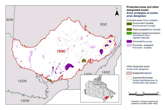
Long Description for Figure 2
Map of protected and designated areas in BCR 12 Quebec Region: Boreal Forest Transition. The map's extent includes southern Quebec and eastern Ontario. The borders of BCR 8ON, 8QC, 12ON, 13ON, 13QC and 14 QC are delineated. Inset in the lower right corner is a map of Canada with BCR 12 highlighted.
BCR 12 covers the southern portion of Quebec, from the Ottawa and St-Lawrence rivers in the south, to about half way up the northern coast of the St-Lawrence in the east, and to about half way up the Ontario/Quebec border in the west. Its northern border is approximately (roughly) oriented SW by NE between the westernmost and easternmost points of the BCR.
The various types of protected and designated areas that exist in the BCR are shown on the map differently, and are explained in the following bilingual legend (appearing to the right of the map):
Protected areas/Aires protégées:
- Environment and Climate Change Canada/Environnement et Changement climatique Canada
- Parks Canada/Parcs Canada
- National Capital Commission/Commission de la capitale nationale
- Provincial/Provincial
- Provincial - projected/Provincial projetée
Other Designated Areas/Autres aires désignées
- RAMSAR/RAMSAR
- Important Bird Areas/Zones importantes pour la conservation des oiseaux
The most common type of protected area shown is provincial projected, appearing as a patchwork of fairly large parks throughout the whole BCR. The next most common type is Provincial, with 4 large parks along the southern border of the BCR as well as a conglomeration of smaller ones in the centre south. There is one large national park visible along the southern border in the east. There is also a visual representation of scale for the map in the legend which indicates 0, 50, 100 and 200 kms. The Projection is Conique conforme Lambert du Quebec (NAD 1983).
Section 1: Summary of results - All Birds, All Habitat
Element 1: Priority species assessment
These Bird Conservation Strategies identify “priority species” from all regularly occurring bird species in each BCR subregion. Species that are vulnerable due to population size, distribution, population trend, abundance and threats are included because of their “conservation concern”. Some widely distributed and abundant “stewardship” species are also included. Stewardship species are included because they typify the national or regional avifauna and/or because they have a large proportion of their range and/or continental population in the subregion; many of these species have some conservation concern, while others may not require specific conservation effort at this time. Species of management concern are also included as priority species when they are at (or above) their desired population objectives but require ongoing management because of their socio-economic importance as game species or because of their impacts on other species or habitats.
The purpose of the prioritization exercise is to focus implementation efforts on the issues of greatest significance for Canadian avifauna. Table 1 provides a full list of all priority species and their reason for inclusion. Tables 2 and 3 summarize the number of priority species in BCR 12-QC by bird group and by the reason for priority status.
The standard method for selecting priority species was used to identify 77 priority species, subspecies or populations (called “species” hereinafter) on a preliminary basis, among the 215 species in BCR12-QC. Regional experts reviewed the preliminary list and removed 22 pre-selected species while 7 other species were added, giving a final list of 62 priority species (Table 1).
The 62 priority species are not distributed equally among the 4 bird groups. Landbirds are the most represented group with 51 species or 82% of all priority species in BCR 12-QC (Table 2). This is a representative picture of the importance of landbirds in the region. They account for 71% of all bird species. The remaining priority species consist of 2 shorebirds, 4 waterbirds and 5 waterfowl species.
The vast majority of priority species (43 of 62) were identified because they are of conservation concern (Table 1, shaded cells). They include 20 species at risk, which are either listed provincially under Quebec's Loi sur les espèces menacées ou vulnérables [Act respecting threatened or vulnerable species], or listed nationally under the Species at Risk Act (SARA) or have been assessed as at risk by the Committee on the Status of Endangered Wildlife in Canada (COSEWIC). Twelve species are considered at risk provincially and nationally, 3 species are considered at risk only provincially (Golden Eagle, Bald Eagle and Sedge Wren), while 5 species are considered at risk only under national legislation (Table 1). The species assessed as at risk by COSEWICbut that are not currently listed on Schedule 1 of SARA are the Bobolink, Wood Thrush, Barn Swallow, Eastern Wood-Pewee and Eastern Meadowlark. Apart from the conservation species, 19 other species have been identified as priority species for stewardship reasons (Table 1; unshaded cells).
Table 1. Priority species in BCR12-QC, population objective, and the reason for priority status. Accessible Version of Table 1.
| Bird group | Total species | Total priority species | Percent listed as priority | Percent of priority list |
|---|---|---|---|---|
| Landbirds | 154 | 51 | 33% | 82% |
| Shorebirds | 15 | 2 | 13% | 3% |
| Waterbirds | 13 | 4 | 31% | 7% |
| Waterfowl | 33 | 5 | 15% | 8% |
| Total | 215 | 62 | 29% | 100% |
| Reason for priority listinga | Landbirds | Shorebirds | Waterbirds | Waterfowl |
|---|---|---|---|---|
| COSEWICb | 16 | 1 | 1 | 1 |
| Federal SARA listedc | 11 | 1 | 1 | 1 |
| Provincially listedd | 14 | 1 | 1 | 0 |
| National/Continental Concernd | 21 | - | - | - |
| Regional Concernd | 18 | - | - | - |
| Continental Stewardshipd | 13 | - | - | - |
| Regional Stewardship d | 18 | - | - | - |
| Conservation Categorye | - | 1 | - | - |
| Priority Tierf | - | - | 4 | - |
| NAWMPh | - | - | - | 3 |
| Expert reviewi | 5 | 1 | 0 | 1 |
a A single species can be on the priority list for more than one reason. Note that not all reasons for inclusion apply to every bird group (indicated by “-”).
b COSEWIC indicates species assessed by the Committee on the Status of Endangered Wildlife in Canada as Endangered, Threatened, or Special Concern.
c Species listed on Schedule 1 of the Species at Risk Act as Endangered; Threatened; or Special Concern.
d Provincially Listed indicates species listed as Threatened, Vulnerable or Likely to be designated as threatened or vulnerable under the Loi sur les espèces menacées ou vulnérables (Quebec).
e See Table 1.
f Conservation category indicates a species ranked in Canada's Shorebird Conservation Plan (Donaldson et al., 2000) as having a 5, 4a, 4b or 3a conservation category in the United States of America and Canada.
g Priority level indicates a species ranked in Canada's Waterbird Conservation Plan (Milko et al., 2003) as belonging to Tier 1 or Tier 2.
h NAWMP indicates a species ranked in the North American Waterfowl Management Plan (Plan Committee, 2004) as having Moderately High, High or Highest breeding or non-breeding conservation and/or monitoring needs in the BCR.
i Species that did not meet the standard criteria but that were added by experts.
Element 2: Habitats important to priority species
Identifying the broad habitat requirements for each priority species within the BCR allowed species to be grouped by shared habitat-based conservation issues and actions. If many priority species associated with the same habitat face similar conservation issues, then conservation action in that habitat may support populations of several priority species. BCR strategies use a modified version of the standard land cover classes developed by the United Nations (Food and Agriculture Organization 2000) to categorize habitats and species were often assigned to more than one habitat class.
Priority species use 11 habitat types in BCR-12 QC (Figure 3). Mixed wood forest is the habitat class used by the greatest number of priority species (22), all landbird species, representing 35% of all priority species in the BCR.
Although they represent only 2% of the BCR 12-QC land area, wetlands are the second type of habitat most used by priority species (20 species or 32% of priority species). This habitat class is used by all 4 bird groups, with landbirds dominating (14 species).
The prominence of landbirds in BCR 12-QC continues in the other most favoured habitat classes. Coniferous forest (27% of priority species), deciduous forest (27%) and riparian areas (21%) are among the habitats most used by priority species. Coniferous and deciduous forests are used by landbirds, and riparian areas are mostly used by landbirds, waterfowl and one species of shorebird (Solitary Sandpiper).
See Section 2 of the complete version of the strategy for additional details on priority species, threats and conservation actions for each habitat type in the BCR 12-QC.
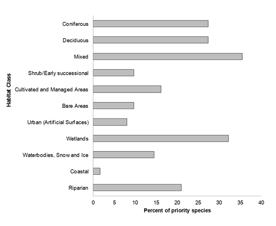
Long Description for Figure 3
| Habitat class | Percent of Priority Species |
|---|---|
| Coniferous | 27 |
| Deciduous | 27 |
| Mixed | 35 |
| Shrub/Early Successional | 10 |
| Cultivated and Managed Areas | 16 |
| Bare Areas | 10 |
| Urban (Artificial Surfaces) | 8 |
| Wetlands | 32 |
| Waterbodies, Snow and Ice | 15 |
| Coastal | 2 |
| Riparian | 21 |
Element 3: Population objectives
Population objectives allow us to measure and evaluate conservation success. The objectives in this strategy are assigned to categories and are based on a quantitative or qualitative assessment of species' population trends. If the population trend of a species is unknown, the objective is set as “assess and maintain”, and a monitoring objective is given. For any species listed under the Species at Risk Act (SARA) or under provincial/territorial endangered species legislation, Bird Conservation Strategies defer to population objectives in available Recovery Strategies and Management Plans. The ultimate measure of conservation success will be the extent to which population objectives have been reached over the next 40 years. Population objectives do not currently factor in feasibility of achievement but are held as a standard against which to measure progress.
Maintaining populations at current levels was the objective assigned to the greatest number of priority species in BCR 12-QC (35% of priority species; Figure 4). With the exception of one species, better population trend data must be acquired for decision-making for all species that have been assigned this objective. This also applies to species whose population objective is “Assess/Maintain” (15% of priority species).
Due to the significant presence of species at risk in BCR 12-QC, population objectives relating to species recovery rank second at 23% of all objectives for the region. In addition to these recovery objectives, which all seek to increase populations of species at risk, population increase objectives were also assigned to 27% of priority species under the categories “Increase,” “Increase 50%” and “Increase 100%.” Overall, 50% of priority species identified in BCR-12 QC were assigned a population increase objective. This reflects the magnitude of the threats affecting bird populations in this BCR.
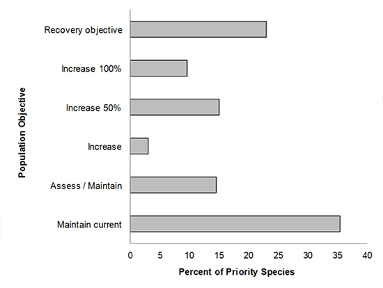
Long Description for Figure 4
| Population Objective | Percent of Priority Species |
|---|---|
| Recovery objective | 22.6 |
| Increase 100% | 9.7 |
| Increase 50% | 14.5 |
| Increase | 3.2 |
| Assess / Maintain | 14.5 |
| Maintain current | 35.5 |
Element 4: Threat assessment for priority species
The threats assessment process identifies threats believed to have a population-level effect on individual priority species. These threats are assigned a relative magnitude (Low, Medium, High, Very High), based on their scope (the proportion of the species' range within the subregion that is impacted) and severity (the relative impact on the priority species' population). This allows us to target conservation actions towards threats with the greatest effects on suites of species or in broad habitat classes. Some well-known conservation issues (such as predation by domestic cats or climate change) may not be identified in the literature as significant threats to populations of an individual priority species and therefore may not be captured in the threat assessment. However, they merit attention in conservation strategies because of the large numbers of individual birds affected in many regions of Canada. We have incorporated them in a separate section of the complete version of the strategy on Widespread Issues, but, unlike other threats, they are not ranked.
Bird populations found in BCR 12-QC face many threats from different sources. No fewer than 342 threats classified into 11 categories and 23 sub-categories have been identified and are summarized in Figure 5. Category “12. Other direct threats,” represented by sub-category “12.1 Information lacking” is the category most frequently associated with priority species in BCR12-QC because it includes 36% of all identified threats (Figure 5). This category, with a “Low” rolled-up overall magnitude, is composed of elements relating to the lack of biological or demographic information required for appropriate population management. Its magnitude is also attributable to the presence of species at risk for which there are no recovery strategies or management plans (Table 4). Only 5 of the 20 species at risk in BCR 12-QC had a recovery strategy or management plan published when this strategy was written. The need for more information was raised for 47 of the 62 priority species (76%) in BCR 12-QC.
Category “5. Biological resource use” has a “High” rolled-up overall magnitude (Table 4) and ranks second in the percentage of threats affecting priority species in BCR 12-QC, with 15% of all threats. Sub-category “5.3 Logging and wood harvesting,” which alone is responsible for 13% of threats, includes forest habitat fragmentation, and the growing scarcity of forest stands with dead trees, large diameter trees and snags with cavities.
Category “2. Agriculture and aquaculture” also has a “High” rolled-up overall magnitude (Table 4) and includes 12% of identified threats, most of which are in sub-category “2.1 Annual and perennial non-timber crops” (Figure 5). This sub-category includes elements such as the conversion of forested farmland to arable land, habitat loss and degradation due to the transition from perennial to annual crops, intensification of agriculture, and drainage and filling of wetlands for agriculture. This sub-category is the only one in BCR 12-QC with a “Very High” rolled-up magnitude.
Sub-categories “1.1 Housing and urban areas” and “1.2 Commercial and industrial areas” of category “1. Residential and commercial development” are the other most common threats at 9% and 7% respectively (Figure 5). These sub-categories include threats such as habitat loss and/or degradation due to drainage and filling of wetlands for residential, commercial or industrial development, loss of woodlands for development, and a decrease in the abundance of prey insects caused by the destruction of wetlands. Overall, category 1 has a “Medium” relative magnitude (Table 4).
Category “7. Natural system modifications” is represented by sub-categories “7.2 Dams and water management/use” and “7.3 Other ecosystem modifications” in BCR 12-QC. Although it describes only a little over 5% of all existing threats, this category's rolled-up overall magnitude remains “High” (Table 4). The only threat in sub-category 7.2 is the danger of nest flooding arising from fluctuations in river and reservoir water levels. Sub-category 7.3 includes threats such as the abandonment of agricultural land, which then becomes unsuitable for some species of farmland birds, fish stocking in historically fishless lakes, closure or disruption of sandpits used for nesting and the transition of shrub habitats to forest habitats.
Category “11. Climate change and severe weather” includes only 5% of identified threats, but its rolled-up overall magnitude is “High” (Table 4). This category includes sub-categories “11.1 Habitat shifting and alteration” and “11.5 Other impacts.” The only threat in sub-category 11.1 is wetland loss and degradation, and the only threat in sub-category 11.5 is the higher frequency of adverse weather events that may affect migration, reproductive success, nesting phenology and prey availability. The threat of reduced prey availability affects aerial insectivores such as various species of swallows, the Common Nighthawk, the Chimney Swift and the Olive-sided Flycatcher.
Other types of threats such as “3. Energy production and mining”, “4. Transportation and service corridors”, “6. Human intrusions and disturbance, ” “8. Invasive and other problematic species and genes” and “9. Pollution” each include less than 5% of all identified threats and have a rolled-up overall magnitude of “ Low” or “Medium” (Figure 5, Table 4).

Long Description for Figure 5
| Threat Sub-category | Low | Medium | High | Very High |
|---|---|---|---|---|
| 1.1 Housing and urban areas | 7.0 | 1.5 | 0.6 | 0.0 |
| 1.2 Commercial and industrial areas | 7.0 | 0.0 | 0.0 | 0.0 |
| 1.3 Tourism and recreation areas | 0.3 | 0.0 | 0.0 | 0.0 |
| 2.1 Annual and perennial non-timber crops | 0.0 | 6.1 | 5.0 | 0.6 |
| 2.2 Wood and pulp plantations | 0.3 | 0.0 | 0.0 | 0.0 |
| 2.3 Livestock farming and ranching | 0.0 | 0.0 | 0.0 | 0.3 |
| 3.1 Oil and gas drilling | 0.3 | 0.0 | 0.0 | 0.0 |
| 3.3 Renewable energy | 0.0 | 0.3 | 0.0 | 0.0 |
| 4.1 Roads and railroads | 0.3 | 0.9 | 0.0 | 0.0 |
| 4.2 Utility and service lines | 0.9 | 0.6 | 0.0 | 0.0 |
| 5.1 Hunting and collecting terrestrial animals | 0.9 | 0.9 | 0.0 | 0.0 |
| 5.3 Logging and wood harvesting | 0.9 | 5.3 | 7.0 | 0.0 |
| 6.1 Recreational activities | 0.0 | 0.6 | 0.0 | 0.0 |
| 7.2 Dams and water management/use | 1.8 | 0.0 | 0.0 | 0.0 |
| 7.3 Other ecosystem modifications | 0.3 | 2.0 | 1.2 | 0.3 |
| 8.1 Invasive non-native/alien species | 0.3 | 0.0 | 0.9 | 0.0 |
| 8.2 Problematic native species | 0.6 | 0.3 | 0.3 | 0.0 |
| 9.2 Industrial and military effluents | 0.3 | 0.0 | 0.3 | 0.0 |
| 9.3 Agricultural and forestry effluents | 0.6 | 0.9 | 1.5 | 0.0 |
| 9.5 Airborne pollutants | 0.0 | 0.0 | 0.3 | 0.0 |
| 11.1 Habitat shifting and alteration | 0.0 | 0.3 | 0.6 | 0.0 |
| 11.5 Other impacts | 0.0 | 0.0 | 4.1 | 0.0 |
| 12.1 Information lacking | 36.0 | 0.0 | 0.0 | 0.0 |
The rolled-up overall magnitude of threats is “High” in 4 of the 11 habitat classes in the BCR 12-QC: deciduous, cultivated and managed areas, urban, and wetlands (Table 4). The last 3 are particularly affected by “High” relative magnitude threats from climate change and severe weather (category 11), while deciduous forests face threats of similar magnitude resulting from biological resource use (category 5) and agriculture (category 2). Cultivated and managed areas are also affected by agricultural threats (“Very High” relative magnitude) and pollution (category 9). Birds found in wetlands are affected by “High” relative magnitude impacts in categories “5. Biological resource use” and “8. Invasive and other problematic species and genes,” while birds utilizing urban areas are particularly affected by residential and commercial development (category 1).
Section 2 of the full strategy provides more details on the threats associated with the various habitat classes. Threats to priority species while they are outside Canada during the non-breeding season were also assessed and are presented in the full strategy in the section entitled Threats Outside Canada.
Table 4. Relative magnitude of identified threats to priority species within BCR 12-QC by threat category and broad habitat class. Accessible Version of Table 4.
Element 5: Conservation objectives
Conservation objectives were designed to address threats and information gaps that were identified for priority species. They describe the environmental conditions and research and monitoring that are thought to be necessary for progress towards population objectives and to understand underlying conservation issues for priority bird species. As conservation objectives are reached, they will collectively contribute to achieving population objectives. Whenever possible, conservation objectives were developed to benefit multiple species, and/or respond to more than one threat.
Conservation objectives have been divided into the seven categories presented in Figure 6. In BCR-12 QC, 43% of suggested conservation objectives are in category “1. Ensure adequate habitat” and include nearly all habitats in BCR 12-QC, with the exception of bare areas and coastal areas. This objective category includes four sub-categories in this BCR: “1.1 Ensure land and resource-use policies and practices maintain or improve bird habitat,” “1.2 Maintain the size, shape and configuration of habitat within the natural range of variation,” “1.3. Ensure the continuation of natural processes that maintain bird habitat” and “1.4 Maintain important bird features on the landscape.”
Objective “7. Improve understanding (of population status, limiting factors, and mitigation)” ranks second with 27% of all suggested conservation objectives. All objectives in this category are from sub-category “7.1 Improve population/demographic monitoring” and demonstrate a need for increased monitoring in this BCR for many priority species in the four bird groups.
Seventeen percent of the conservation objectives involve managing individual species (category 3). Three quarters of the objectives in this category are from sub-category “3.4 Implement recovery plans for species at risk” because there are 20 species at risk in BCR 12-QC. Sub-categories “3.3 Reduce parasitism/predation” and “3.5 Prevent and control the spread of invasive and exotic species” complete this category's objectives.
Objective “2. Reduce mortality/increase productivity” represents 5% of the conservation objectives in BCR 12-QC. Nearly half of this category's objectives are in sub-category “2.1 Reduce mortality and/or sub-lethal effects from pesticide use,” while nearly one quarter are from sub-category “2.7. Reduce incidental mortality from collisions.” The other objectives in this category are part of sub-categories “2.2. Reduce mortality and/or sub-lethal effects from exposure to contaminants,” “2.4 Reduce incidental mortality” and “2.8. Reduce mortality from legal or illegal hunting, and persecution.”
Categories “6. Manage for climate change” and “4. Reduce disturbance” accounted for 5% and 2% of all the objectives raised for BCR 12-QC. Sub-category “6.2 Manage for habitat resilience as climate changes,” which primarily involves aerial insectivores, is the only sub-category included in category 6. All category 4 conservation objectives are from sub-category “4.1. Reduce disturbance from human recreation” and are mostly related to priority species that are nesting or gathering near the lakes. No objectives have been assigned to sub-category “5.5. Ensure adequate food supplies” in BCR 12-QC.
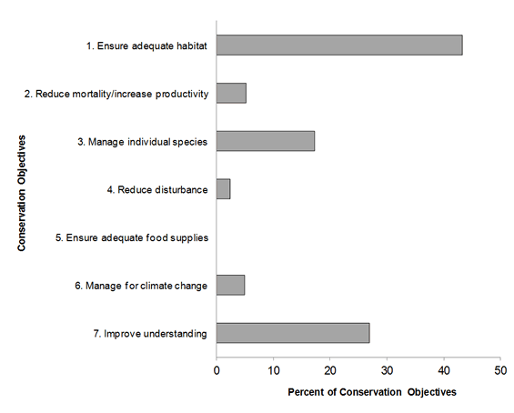
Long Description for Figure 6
| Conservation Objective | Percent of Conservation Objectives |
|---|---|
| 1 Ensure adequate habitat | 43.3 |
| 2 Reduce mortality/increase productivity | 5.3 |
| 3 Manage individual species | 17.3 |
| 4 Reduce disturbance | 2.3 |
| 5 Ensure adequate food supplies | 0.0 |
| 6 Manage for climate change | 5.0 |
| 7 Improve understanding | 26.9 |
Element 6: Recommended actions
Recommended actions indicate on-the-ground activities that will help to achieve the conservation objectives (Figure 7). Actions are strategic rather than highly detailed and prescriptive. Whenever possible, recommended actions benefit multiple species and/or respond to more than one threat. Recommended actions defer to or support those provided in recovery documents for species at risk at the federal, provincial or territorial level, but will usually be more general than those developed for individual species.
Figure 7 shows that 32% of the actions recommended in BCR12-QC are in sub-category “8.2 Monitoring.” The high frequency of this recommendation is primarily due to the lack of biological or demographic information on the priority species in the BCR. The actions suggested in this category include increasing the coverage of the Breeding Bird Survey (BBS), conducting specific surveys (for example, surveys involving high altitude birds, birds nesting in boreal forests or nocturnal birds), expanding the current migration monitoring program, and maintaining waterfowl banding and survey programs.
Sub-category “1.1 Site/area protection” is the second largest, representing 25% of all recommended actions. The actions recommended in this category particularly target wetlands and include protecting a variety of wetlands through various mechanisms such as stewardship or the legal designation of wetlands as conservation areas, the adoption of municipal urban plans that protect wetlands and woodlands, and the protection of large tracts of mature forest. These actions are designed to minimize the impact of threats relating to residential and commercial development, as well as agriculture.
The adoption of standards and beneficial practices, mainly in agriculture and forestry (5.3), is the third most frequently mentioned action sub-category (11%). More specifically, developing beneficial practices to reduce accidental bird mortality in agricultural areas, implementing silvicultural treatments that maintain natural habitat structure and supporting sustainable agriculture in Quebec are some actions suggested for overcoming several threats relating to annual and perennial crops, and logging and wood harvesting.
Sub-category “3.2 Species recovery” represents 10% of the recommended actions and includes continued implementation of recovery strategies or management plans for species at risk. Sub-category “5.2 Policies and regulations” includes 8% of the recommended actions and refers primarily to improving the protection of wetlands through available policies, regulations and stewardship tools.
More details on recommended actions for the various habitat classes are presented in Section 2 of the full strategy.

Long Description for Figure 7
| Action Sub-category | Percent of Recommended Actions |
|---|---|
| 1.1 Site/area protection | 25.1 |
| 2.1 Site/area management | 2.8 |
| 2.2 Invasive/problematic species control | 0.3 |
| 2.3 Habitat and natural process restoration | 3.1 |
| 3.2 Species recovery | 10.4 |
| 4.3 Awareness and communications | 1.2 |
| 5.2 Policies and regulations | 7.9 |
| 5.3 Private sector standards and codes | 11.5 |
| 5.4 Compliance and enforcement | 0.6 |
| 6.2 Substitution | 2.6 |
| 6.4 Conservation payments | 2.5 |
| 7.2 Alliance and partnership development | 0.2 |
| 8.1 Research | 0.2 |
| 8.2 Monitoring | 31.6 |
References
Aboriginal Affairs and Northern Development Canada. 2010. Aboriginal peoples in Quebec (Page viewed August 7, 2012).
Aubry, Y. and R. Cotter. 2007. Quebec Shorebird Conservation Plan. Environment and Climate Change Canada, Canadian Wildlife Service, Quebec region, Sainte-Foy. xvi + 203 p.
Chapdelaine, G. and J.-F. Rail 2004. Quebec's Waterbird Conservation Plan. Migratory Bird Division, Canadian Wildlife Service, Quebec Region, Environment and Climate Change Canada, Sainte-Foy, Quebec. 99 p.
Donaldson, G. M., C. Hyslop, R. I. G. Morrison, H. L. Dickson, and I. Davidson (editors). 2000. Canadian Shorebird Conservation Plan (PDF; 1.92 MB). Canadian Wildlife Service, Environment and Climate Change Canada, Ottawa, Ontario. 27 pp.
Drolet, B., V. Carignan, M.-A. Vaillancourt and G. Falardeau. 2010. Plan de conservation des oiseaux terrestres du Quebec : volume 1, oiseaux des milieux forestiers. Unpublished working document, Environment and Climate Change Canada, Canadian Wildlife Service, Quebec region.
Ecological Stratification Working Group 1996. A National Ecological Framework for Canada. Agriculture and Agri-Food Canada, Research Branch, Centre for Land and Biological Resources Research and Environment and Climate Change Canada, State of the Environment Directorate, Ecozone Analysis Branch, Ottawa/Hull. vii + 125 pages + Map of Canada 1 / 7,500,000.
Falardeau, G., V. Carignan, B. Drolet and M.-A. Vaillancourt. 2010. Plan de conservation des oiseaux terrestres du Quebec, volume 2 : les oiseaux des milieux agricoles, humides, urbains, arctiques, alpins et des falaises.Unpublished working document, Environment and Climate Change Canada, Canadian Wildlife Service, Quebec region.
Food and Agriculture Organization of the United Nations (UN-FAO). 2000. Land Cover Classification System. Food and Agriculture Organization of the United Nations, Rome.
Kennedy, J.A., E.A. Krebs and A.F. Camfield. 2012. Manual for implementing all-bird conservation plans in each of Canada's Bird Conservation Regions, April 2012 version. Canadian Wildlife Service, Environment and Climate Change Canada. Ottawa, Ontario.
Li, T. and J.-P. Ducruc. 1999. Les provinces naturelles. Niveau I du cadre écologique de référence du Quebec (in French only). Department of the Environment. [Online] (Page viewed August 9, 2012)
Lepage, C., D. Bordage, D. Dauphin, F. Bolduc and B. Audet. In progress. Quebec Waterfowl Conservation Plan, 2010.Environment and Climate Change Canada, Canadian Wildlife Service, Quebec region, Quebec City.
Milko, R., L. Dickson, R. Elliot and G. Donaldson. 2003. Wings Over Water: Canada's Waterbird Conservation Plan. Canadian Wildlife Service, Environment and Climate Change Canada. Ottawa, Ontario. 28 pages.
Ministère du Développement durable, de l'Environnement et des Parcs. 2002. Portrait général de l'eau(in French only). (Accessed April 4, 2013)
Ministère du Développement durable, de l'Environnement, de la Faune et des Parcs. 2013a. Liste des espèces désignées menacées ou vulnérables au Quebec (in French only)[Online]. (Accessed April 4, 2013)
Ministère du Développement durable, de l'Environnement,de la Faune et des Parcs. 2013b. Ensemencement des plans d'eau (in French only)[Online]. (Accessed April 4, 2013)
Ministère des Ressources naturelles. 2013. Zones de végétation et domaines bioclimatiques du Quebec (in French only)[Online]. (Accessed April 4 2013)
Natural Resources Canada. 2009. The Atlas of Canada: Mountains [Online]. (Page viewed August 7, 2012)
North American Waterfowl Management Plan, Plan Committee. 2004. North American Waterfowl Management Plan 2004. Implementation Framework: Strengthening the Biological Foundation. Canadian Wildlife Service, U.S. Fish and Wildlife Service, Secretaria de Medio Ambiente y Recursos Naturales, 106 pp.
Panjabi, A. O., E. H. Dunn, P. J. Blancher, W. C. Hunter, B. Altman, J. Bart, C. J. Beardmore, H. Berlanga, G. S. Butcher, S. K. Davis, D. W. Demarest, R. Dettmers, W. Easton, H. Gomez de Silva Garza, E. E. Iñigo-Elias, D. N. Pashley, C. J. Ralph, T. D. Rich, K. V. Rosenberg, C. M. Rustay, J. M. Ruth, J. S. Wendt, and T. C. Will. 2005. The Partners in Flight Handbook on Species Assessment. Version 2005 (PDF; 405 KB). Partners in Flight Technical Series No. 3. Rocky Mountain Bird Observatory website.
Rich, T.D., C.J. Beardmore, H. Berlanga, P.J. Blancher, M.S.W. Bradstreet, G.S. Butcher, D.W. Demarest, E.H. Dunn, W.C. Hunter, E.E. Iñigo-Elias, J.A. Kennedy, A.M. Martell, A.O. Panjabi, D.N. Pashley, K.V. Rosenberg, C.M. Rustay, J.S. Wendt and T.C. Will. 2004. Partners in Flight North American Landbird Conservation Plan. Cornell Lab of Ornithology. Ithaca, New York.
Species at Risk Public Registry. 2012. Schedule 1: List of Wildlife Species at Risk [Online]. (Page viewed August 13, 2012)
Statistics Canada. 2012. Population and dwelling counts, for Canada, provinces and territories, and census subdivisions (municipalities), 2011 and 2006 censuses. (Page viewed August 8, 2012).