
Bird Conservation Strategy for region 13 in Quebec
- Abridged version -
October 2013

The abridged version of the strategy available here contains a summary of the results, but does not include an analysis of conservation needs by habitat, a discussion of widespread conservation issues, or the identification of research and monitoring needs.
Other formats available for this document:
Table of contents
- Preface
- Acknowledgements
- Bird Conservation Strategy for Bird Conservation Region 13 in Quebec Region - Lower Great Lakes/St. Lawrence Plain
- Executive summary
- Introduction: Bird Conservation Strategies
- Section 1: Summary of results - All Birds, All Habitats
- References
List of figures
- Figure 1. Landcover in BCR 13 in Quebec Region: Lower Great Lakes/St. Lawrence Plain.
- Figure 2. Map of protected and designated areas in BCR 13 in Quebec Region: Lower Great Lakes/St. Lawrence Plain.
- Figure 3. Percent of priority species that are associated with each habitat type in BCR 13-QC.
- Figure 4. Percent of priority species that are associated with each population objective category in BCR 13-QC.
- Figure 5. Percent of identified threats to priority species within BCR 13-QC by threat sub-category.
- Figure 6. Percent of all conservation objectives assigned to each conservation objective category in BCR 13-QC.
- Figure 7. Percent of recommended actions assigned to each sub-category in BCR 13-QC.
List of tables
- Table 1. Priority species in BCR 13 Quebec, population objective and the reason for priority status.
- Table 2. Summary of priority species, by bird group, in BCR 13-QC.
- Table 3. Number of priority species in BCR 13-QC by reason for priority status.
- Table 4. Relative magnitude of identified threats to priority species within BCR 13-QC by threat category and broad habitat class.
Preface
Environment and Climate Change Canada led the development of all-bird conservation strategies in each of Canada’s Bird Conservation Regions (BCRs) by drafting new strategies and integrating new and existing strategies into an all-bird framework. These integrated all-bird conservation strategies will serve as a basis for implementing bird conservation across Canada, and will also guide Canadian support for conservation work in other countries important to Canada’s migrant birds. Input to the strategies from Environment and Climate Change Canada’s conservation partners is as essential as their collaboration in implementing their recommendations.
Environment and Climate Change Canada has developed national standards for strategies to ensure consistency of approach across BCRs. Bird Conservation Strategies will provide the context from which specific implementation plans can be developed for each BCR, building on the programs currently in place through Joint Ventures or other partnerships. Landowners including Aboriginal peoples will be consulted prior to implementation.
Conservation objectives and recommended actions from the conservation strategies will be used as the biological basis to develop guidelines and beneficial management practices that support compliance with regulations under the Migratory Birds Convention Act, 1994.
Acknowledgements
Stéphane Légaré, Véronique Connolly, Benoît Audet and François Fournier were the main authors of this document which follows templates developed by Alaine Camfield, Judith Kennedy and Elsie Krebs with the help of the BCR planners in each of the Canadian Wildlife Service regions throughout Canada. However, work of this scope cannot be accomplished without the contribution of other colleagues who provided or validated technical information, commented on earlier draft versions of the strategy, and supported the planning process. We would like to thank the following people: Matthieu Allard, Yves Aubry, Luc Bélanger, Martine Benoît, Daniel Bordage, Pierre Brousseau, Vincent Carignan, Richard Cotter, Marie-France Dalcourt, Emmanuel Dalpé-Charron, Bruno Drolet, Gilles Falardeau, Patricia Houle, Benoît Jobin, Sandra Labrecque, Claudie Latendresse, Josée Lefebvre, Christine Lepage, Jean-François Rail and François Shaffer.
Bird Conservation Strategy for Bird Conservation Region 13 in Quebec Region - Lower Great Lakes/St. Lawrence Plain
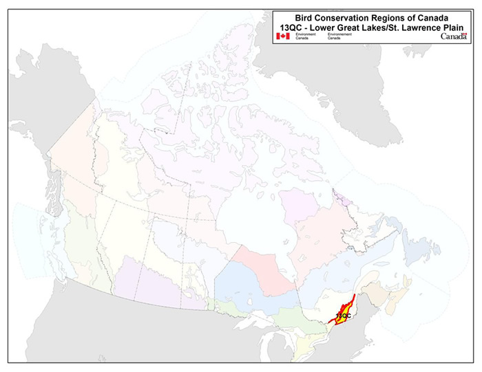
Long description for the Map
Map of the Bird Conservation Regions (BCRs) of Canada with BCR 13 QC: Lower Great Lakes / St. Lawrence Plain highlighted. The extent of the map includes Canada, with Alaska, Greenland and the northern portion of the U.S. also appearing. The map is divided by BCR (12 Canadian BCRs in total), with various colours, and their exact locations and sizes are indistinguishable, aside from BCR 13.
The highlighted BCR 13QC covers a small part of southern Quebec. It includes the eastern extent of the Ottawa River and continues east along the St. Lawrence River toward the Gaspé peninsula. Legend: Bird Conservation Regions of Canada. 13QC - Lower Great Lakes / St. Lawrence Plain; Environment and Climate Change Canada logo, and Government of Canada logo.
Executive summary
In Quebec, the Lower Great Lakes and St. Lawrence Plain Bird Conservation Region (BCR 13-QC) corresponds approximately with the St. Lawrence Lowlands. Although it is the smallest BCR in the province, it is the most densely populated with close to 75% of Quebec’s population. The mild climate and fertile soil that characterize this area have been major drivers of agricultural development, so much so that farmland now accounts for nearly half of the land cover in BCR 13-QC. Forest cover, composed mainly of deciduous and mixed vegetation, has been reduced considerably as a result of agricultural and urban development and is therefore quite fragmented. Despite the significant change in natural cover this region has experienced, this BCR boasts the highest biodiversity in Quebec. In terms of avifauna, BCR 13-QC is notable in that it includes the St. Lawrence corridor, a major migration route.
Following an assessment of the 240 bird species found in BCR 13-QC, 68 species were identified as priorities in this BCR. The priority list includes species from 4 bird groups: landbirds (65%), waterfowl (13%), waterbirds (12%) and shorebirds (10%). These priority species include 22 federal and/or provincial species at risk, 8 stewardship species and 2 overabundant species. The priority species found in BCR 13-QC use 12 different habitat classes. The most commonly used are wetlands (46% of priority species), cultivated and managed areas (38%), deciduous forests (26%), and herbaceous habitats (22%).
Each priority species was assigned a population objective based on its population trend. Maintaining populations at current levels was the objective assigned to 37% of priority species; however, better population trend data is required for more than half of these. A recovery objective was assigned to 21% of the species (all are species at risk), and population increase objectives were assigned to 39% of the priority species. Overall, 60% of the priority species identified in BCR-13 QC were assigned a population increase objective, reflecting the magnitude of the threats to bird populations in this BCR.
A threat assessment identified a number of conservation issues facing priority species in the various habitats of BCR 13-QC, as well as the major impacts such threats have in many habitat classes. Major threats include habitat loss and degradation due to the conversion from perennial to annual crops, the drainage and filling of wetlands for agricultural, residential and commercial development, and the overuse of pesticides. Although conservation issues in BCR 13-QC are particularly pervasive in managed and cultivated areas as well as wetlands, neither forested environments nor aquatic ecosystems are immune. The lack of biological or demographic data on priority species and the presence of species at risk without a completed recovery strategy or management plan were also considered to be significant conservation issues in BCR 13-QC, as a total of 65% of priority species are affected.
Conservation objectives have been established to address threats and information gaps relating to priority species. In BCR 13-QC, conservation objectives chiefly involve providing suitable habitat for priority species by ensuring, for example, that resource and land use policies and practices maintain or improve bird habitat. Objectives seeking to improve understanding of population status as well as management of specific species are also among the objectives most frequently mentioned in BCR 13-QC. These objectives are meant to address the lack of information on the ecology and demographics of many priority species and to continue to establish recovery strategies and management plans for species at risk.
Conservation actions have been proposed for priority species in BCR 13-QC to achieve the proposed conservation objectives. A large proportion of the recommended actions involve the protection of sites or areas that are important for priority species, which is indicative of the pressure on habitats and the species they support in this highly populated and exploited region. Population monitoring is also suggested in many of the actions proposed and includes the development and implementation of specific monitoring measures for certain groups of species, such as nocturnal birds, as well as maintaining or updating existing activities, such as waterfowl survey programs and migration monitoring. Lastly, the development and adoption of beneficial management practices, especially in the agriculture and forestry sectors, is a frequently recommended conservation action.
Migratory birds found in BCR 13-QC also face threats that are difficult to analyze with the standardized methodology used in this strategy. These threats include widespread issues that may not apply to a particular habitat (e.g. collisions with human-made structures, air pollution and climate change), research needs and population monitoring, as well as threats to migratory birds when they are outside Canada. An overview of these issues, the affected species and the associated recommended conservation actions is also presented.
Introduction: Bird Conservation Strategies
Context
This document is one of a suite of Bird Conservation Region strategies (BCR strategies) that have been drafted by Environment and Climate Change Canada for all regions of Canada. These strategies respond to Environment and Climate Change Canada’s need for integrated and clearly articulated bird conservation priorities to support the implementation of Canada’s migratory birds program, both domestically and internationally. This suite of strategies builds on existing conservation plans for the four “bird groups” (waterfowl,Footnote1 waterbirds,Footnote2 shorebirdsFootnote3 and landbirdsFootnote4) in most regions of Canada, as well as on national and continental plans, and includes birds under provincial/territorial jurisdiction. These new strategies also establish standard conservation planning methods across Canada and fill gaps, as previous regional plans do not cover all areas of Canada or all bird groups.
These strategies present a compendium of required actions based on the general philosophy of achieving scientifically based desired population levels as promoted by the four pillar initiatives of bird conservation. Desired population levels are not necessarily the same as minimum viable or sustainable populations, but represent the state of the habitat/landscape at a time prior to recent dramatic population declines in many species from threats known and unknown. The threats identified in these strategies were compiled using currently available scientific information and expert opinion. The corresponding conservation objectives and actions will contribute to stabilizing populations at desired levels.
The BCR strategies are not highly prescriptive. In most cases, practitioners will need to consult additional information sources at local scales to provide sufficient detail to implement the recommendations of the strategies. Tools such as beneficial management practices will also be helpful in guiding implementation. Partners interested in participating in the implementation of these strategies, such as those involved in the habitat Joint Ventures established under the North American Waterfowl Management Plan (NAWMP), are familiar with the type of detailed implementation planning required to coordinate and undertake on-the-ground activities.
Strategy Structure
Section 1 of this strategy, published here, presents general information about the BCR and the subregion, with an overview of the six elementsFootnote5 that provide a summary of the state of bird conservation at the sub-regional level. Section 2, included in the full version of the strategy, provides more detail on the threats, objectives and actions for priority species grouped by each of the broad habitat types in the subregion. Section 3, also included in the full strategy, presents additional widespread conservation issues that are not specific to a particular habitat or were not captured by the threat assessment for individual species, as well as research and monitoring needs, and threats to migratory birds while they are outside of Canada. The approach and methodology are summarized in the appendices of the full strategy, but details are available in a separate document (Kennedy et al. 2012). A national database houses all the underlying information summarized in this strategy and is available from Environment and Climate Change Canada.
Characteristics of Bird Conservation Region 13-QC
The Lower Great Lakes and St. Lawrence Plain Bird Conservation Region (BCR 13) straddles the Canada-U.S. border and extends from the south of Lake Erie to the St. Lawrence Estuary. In Quebec, BCR 13 is bordered to the west by Ontario and to the south by the U.S., and stretches along the shores of the St. Lawrence to Cap Tourmente on the north bank; it then continues on the south bank all the way to Saint-Simon (Fig. 1). All the islands of the St. Lawrence River from the Ontario border to Île-aux-Oies are part of this BCR. They include Île d'Orléans and the archipelagos of Varennes, Contrecoeur, Lake St. Pierre and Isle-aux-Grues. BCR 13-QC covers an area of 33 434 km2 (31 201 km2 over land and 2 233 km2 over water), making this the smallest of the BCRs in the province. The term BCR 13-QC will be used in the rest of this document to refer to the Quebec portion of this BCR.
Figure 1. Landcover in BCR 13 in Quebec Region: Lower Great Lakes/St. Lawrence Plain.
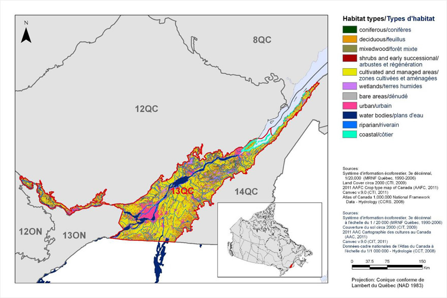
Long description for Figure 1
Map of the landcover in BCR 13, Quebec Region: Lower Great Lakes / St. Lawrence Plain. The map's extent includes eastern Ontario, southern Quebec, and northern parts of New York state and the New England states; the borders of adjoining BCRs are delineated. BCR 13 QC covers a small part of southern Quebec. It includes the eastern extent of the Ottawa River and continues east along the St. Lawrence River toward the Gaspé peninsula.
The various habitat types that exist in the BCR are shown on the map, and are explained in the following bilingual legend (appearing to the right of the map):
- Coniferous/conifères
- Deciduous/feuillus
- Mixedwood/forêt mixte
- Shrubs and early successional/arbustes et régénération
- Herbaceous/herbacées
- Cultivated and managed areas/zone cultivées et aménagées
- Lichens and mosses/lichens et mousses
- Wetlands/terres humides
- Alpine/alpin
- Snow and ice/neige et glace
- Bare areas/denude
- Urban/urbain
- Water bodies /plans d'eau
- Riparian/riverain
- Coastal/côtier
The remaining text in the legend provides the data sources for the map (i.e. Land Cover Map of Canada 2005 (CCRS, 2008), the projection of the map (i.e. UTM 9 (NAD 1983)) and there is a visual representation of the scale of the map.
For BCR 13 QC, the most common habitat type is cultivated and managed areas, followed by mixedwood forests and urban areas.
Physical environment
Topography
The topography of BCR 13-QC is generally flat, with the exception of seven of the nine Monteregian Hills, namely Mount Royal (233 m), Saint-Bruno (218 m), Saint-Hilaire (403 m), Rougemont (390 m), Yamaska (416 m), Shefford (525 m) and Saint-Grégoire (265 m) (Commission de toponymie Quebec 2012). The rest of the St. Lawrence Plain, which makes up most of BCR 13-QC, has an elevation of less than 100 m (Li and Ducruc 1999).
Hydrography and hydrology
The hydrography of BCR 13-QC is dominated by the St. Lawrence River and the downstream portion of its tributaries, the largest of which are the Richelieu, Yamaska, Nicolet and Bécancour rivers on the south bank, and the Ottawa, Assomption, Saint-Maurice and Jacques-Cartier rivers on the north bank. This BCR also includes four major fluvial lakes: Lake Saint-François (239 km2), Lake of Two Mountains (149 km2), Lake Saint-Louis (147 km2) and Lake Saint-Pierre (362 km2; Government of Quebec 2002).
Climate
BCR 13-QC's climate is the warmest in Quebec and is characterized by relatively hot summers and cool winters. The average annual temperature is about 5°C, while the average summer temperature is 16.5°C and the average winter temperature is -7°C. The average annual precipitation ranges from 800 to 1000 mm (Ecological Stratification Working Group 1996).
Land cover and land use
The mild climate and fertile soil that characterize the land in BCR 13-QC provide conditions suitable for agricultural, and thus nearly half of the land cover is cultivated and managed areas (Fig. 1), mostly annual crops (e.g., grain corn and soybean; Statistics Canada 2010a). Since BCR 13-QC is the most populated BCR in Quebec, agricultural and urban development has been a major contributing factor to the loss and fragmentation of forest cover (Bélanger and Grenier 2002). Forest cover currently accounts for 28% of BCR 13-QC's area and consists primarily of a mixed, deciduous-dominated forest that is very fragmented (Li et Ducruc, 1999). A little over 5% of the area is wetlands, which consists mainly of bogs, swamps and freshwater marshes. Most of the land in BCR 13-QC is privately owned (Government of Quebec 2012).
Biological environment
Vegetation
BCR 13-QC is located in the northern temperate vegetation zone dominated by deciduous and mixed forest stands (Ministère des Ressources naturelles 2013). The western portion of BCR 13-QC is represented almost entirely by the sugar maple-bitternut hickory bioclimatic domain, while the eastern portion is represented mainly by the sugar maple-basswood domain and, to a minor degree, by the balsam fir-yellow birch domain along the riparian strip from Kamouraska to Saint-Simon.
The sugar maple-bitternut hickory domain has the most diverse flora in Quebec and includes certain species that are at the northern limit of their range. This domain is characterized by the dominance of sugar maple; its main species include basswood, white ash and American beech, in addition to bitternut and shagbark hickory (Gratton 2010). The sugar maple-basswood domain contains sugar maple, basswood, white ash, American beech and ironwood as well as more boreal species such as yellow birch. The balsam fir-yellow birch domain has a larger proportion of conifers compared to the two other bioclimatic domains in the BCR and includes balsam fir, white spruce, Eastern white cedar and yellow birch.
Wildlife
The area covered by BCR 13-QC is home to a wide variety of animal species despite significant human disturbances in the region (Gratton 2010). Abundant or representative mammals include the White-tailed Deer, Coyote, Racoon, Grey Squirrel, Eastern Cottontail and Muskrat. Four mammal species likely to be designated threatened or vulnerable in Quebec live in a number of the region's remaining forests and include the Eastern Red Bat, Silver-Haired Bat, Hoary Bat and Southern Flying Squirrel (Ministère du Développement durable, de l'Environnement, de la Faune et des Parcs 2013).
BCR 13-QC has the widest diversity of amphibians and reptiles in Quebec (Jobin and DesGranges 2012). Representative species are the American Toad, Northern Spring Peeper, Leopard Frog, Garter Snake, Painted Turtle and Common Snapping Turtle. Many are designated species at risk in Canada or Quebec, namely the Mountain Dusky Salamander, Western Chorus Frog, Common Musk Turtle, Spiny Softshell Turtle and Map Turtle (Ministère du Développement durable, de l'Environnement, de la Faune et des Parcs 2013; Species at Risk Public Registry 2012).
The presence of the St. Lawrence River and other major rivers in BCR 13-QC means that fish fauna is also diverse in the region (Gratton 2010). This BCR contains the only fish species endemic to Quebec, the Copper Redhorse, whose only two known spawning grounds are in the Richelieu River. Other representative species include the Yellow Perch, Brown Bullhead, American Shad, Lake Sturgeon and American Eel.
BCR 13-QC supports a large avian diversity, with many of Quebec's bird species attaining their maximum abundance there (Falardeau et al. 2010). Waterfowl is also well represented in this BCR. The Canada Goose as well as diving and dabbling ducks use the wetlands and agricultural fields while nesting, and hundreds of thousands of birds (particularly snow geese and dabbling ducks) use the region as a staging area during spring and fall migration. BCR 13-QC has the largest diversity of rural species in Quebec, including the Bobolink, Eastern Meadowlark, Horned Lark, Savannah Sparrow and Vesper Sparrow. Species characteristic of urban areas in the BCR include the House Sparrow, European Starling and Rock Pigeon-three introduced species-as well as the Ring-billed Gull. The Northern Cardinal and House Finch, both fairly rare 30 years ago, are now common in the urban areas of BCR 13-QC (Falardeau et al. 2010). Forest birds representative of this BCR include the Cooper's Hawk, Red-shouldered Hawk, Eastern Screech-Owl, Eastern Whip-poor-will, White-breasted Nuthatch and Wood Thrush (Drolet et al. 2010). The Herring Gull, Great Blue Heron, Black-crowned Night-Heron, Common Tern and Double-crested Cormorant are some of the waterbirds representative of BCR 13-QC (Chapdelaine and Rail 2004). The Killdeer, Wilson's Snipe and American Woodcock are species of shorebirds known to breed in this BCR (Aubry and Cotter 2007).
Human environment
BCR 13-QC is the most populated area in Quebec with close to 5.5 million people, nearly 75% of the entire population of that province (adapted from Statistics Canada 2010a; 2010b). Major population centres include Montréal (1 649 519 inhabitants), Quebec (516 622), Laval (401 553) and Trois-Rivières (131 338; Statistics Canada 2012). BCR 13-QC comprises 7 Aboriginal communities with a little over 17 000 inhabitants, 85% of whom live in the western part of the BCR in the Mohawk communities of Kahnawake, Akwesasne and Kanesatake (Aboriginal Affairs and Northern Development Canada 2010; Ministère des Affaires municipales des Régions et de l'Occupation du territoire 2010).
Protected and designated areas
Protected areas account for close to 5% of the land in BCR 13-QC (Fig. 2). Five Quebec national parks (responsibility of Quebec's Ministère du Développement durable, de l'Environnement, de la Faune et des Parcs) are located within this BCR and cover a total area of 78 km2. They are Plaisance, Oka, Îles-de-Boucherville, Mont-Saint-Bruno and Yamaska national parks. This BCR also includes the southeast tip of Gatineau Park (responsibility of the National Capital Commission) and 5 of Quebec's 8 national wildlife areas (NWAs) (responsibility of Environment and Climate Change Canada): Lac Saint-François, Îles de la Paix, Îles de Contrecoeur, Cap Tourmente (partly in BCR 12-QC) and Baie de l'Isle-Verte (partly in BCR 14-QC). Together, these NWAs cover an area of approximately 30 km2 in BCR 13-QC. Thirteen migratory bird sanctuaries (MBSs) (responsibility of Environment and Climate Change Canada) are located in BCR 13-QC and cover a total area of 77 km2. An area of 1225 km2 is occupied by no less than 190 waterbird staging areas (responsibility of Quebec's Ministère du Développement durable, de l'Environnement, de la Faune et des Parcs), most of which are located along the St. Lawrence and Ottawa rivers.
Lastly, BCR 13-QC also includes designated areas that do not have legal protection status. It has 25 Important Bird Areas (IBAs) and four sites designated under the Convention on Wetlands of International Importance (Ramsar). The 25 IBAs have a total area of slightly more than 700 km2 and generally encompass NWAs and MBSs. The Ramsar sites of BCR 13-QC correspond approximately to Lake St. Pierre and the NWAs of Lac Saint-François, Cap Tourmente and Baie de l'Isle-Verte (Fig. 2).
Figure 2. Map of protected and designated areas in BCR 13 in Quebec Region: Lower Great Lakes/St. Lawrence Plain.
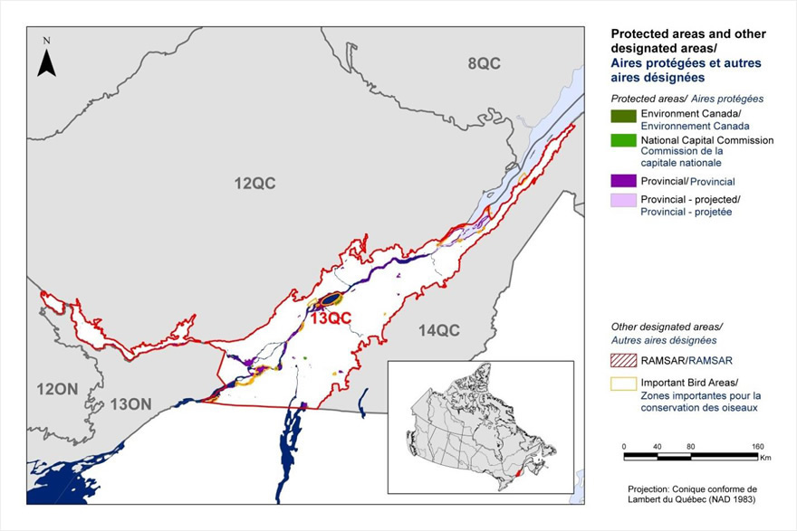
Long description for Figure 2
Map of protected and other designated areas in BCR 13, Quebec Region: Lower Great Lakes / St. Lawrence Plain. The map's extent includes eastern Ontario, southern Quebec, and northern parts of New York state and the New England states; the borders of adjoining BCRs are delineated. BCR 13 QC covers a small part of southern Quebec. It includes the eastern extent of the Ottawa River and continues east along the St. Lawrence River toward the Gaspé peninsula.
The various types of protected areas that exist in the BCR are shown on the map, and are explained in the following bilingual legend (appearing to the right of the map):
Protected areas/Aires protégées
- Agriculture and Agri-Food Canada/Agriculture et Agroalimentaire Canada
- Fisheries and Oceans Canada/Pêches et Océans Canada
- Environment and Climate Change Canada/Environnement et Changement climatique Canada
- Parks Canada/Parcs Canada
- Aboriginal Affairs and Northern Development Canada/Affaires autochtones et Développement du Nord Canada
- Provincial/Provincial
Other designated areas/autres aires désignées
- Important Bird Areas/ Aires d'importance pour les oiseaux
- Ramsar/Ramsar
There is also a visual representation of scale for the map in the legend and the projection of the map (i.e. UTM 9 (NAD 1983)).
Most of the protected areas are too small to be seen, though a couple of provincial park are visible. There are also several small Important Bird Areas along the St. Lawrence River.
Section 1: Summary of results - All Birds, All Habitats
Element 1: Priority species assessment
These Bird Conservation Strategies identify “priority species” from all regularly occurring bird species in each BCR subregion. Species that are vulnerable due to population size, distribution, population trend, abundance and threats are included because of their “conservation concern”. Some widely distributed and abundant “stewardship” species are also included. Stewardship species are included because they typify the national or regional avifauna and/or because they have a large proportion of their range and/or continental population in the subregion; many of these species have some conservation concern, while others may not require specific conservation effort at this time. Species of management concern are also included as priority species when they are at (or above) their desired population objectives but require ongoing management because of their socio-economic importance as game species or because of their impacts on other species or habitats.
The purpose of the prioritization exercise is to focus implementation efforts on the issues of greatest significance for Canadian avifauna. Table 1 provides a full list of all priority species and their reason for inclusion. Tables 2 and 3 summarize the number of priority species in BCR 13-QC by bird group and by the reason for priority status.
The standard method for selecting priority species identified, on a preliminary basis, 81 priority species, subspecies or populations (called “species” hereinafter) from the 240 bird species in BCR 13-QC. Regional experts reviewed the preliminary list and excluded 28 previously selected species and added 15 others, making the final count of priority species 68 (Table 1).
The 68 priority species identified are not distributed equally among the 4 bird groups. Landbirds are the most represented group with 44 species or 65% of all priority species in BCR 13-QC (Table 2). This is representative of the importance of landbirds in the region, as they account for 63% of all species. The 8 priority species of waterbirds account for 40% of all species in this group in BCR 13-QC, which is indicative, to a certain degree, of the group's precariousness in the sub-region. Waterfowl and shorebirds have 9 and 7 priority species, respectively.
The vast majority of priority species (58 of 68) were identified for conservation reasons (Table 1, shaded cells). They include 22 species at risk, which are listed provincially under the Loi sur les espèces menacées ou vulnérables [Act respecting threatened or vulnerable species], nationally under the Species at Risk Act (SARA), or have been assessed by the Committee on the Status of Endangered Wildlife in Canada (COSEWIC; Table 3). Thirteen species are considered at risk both federally and provincially, 4 bird species are considered at risk only at the provincial level (Nelson's Sharp-tailed Sparrow, Grasshopper Sparrow, Bald Eagle and Sedge Wren). The Bobolink, Wood Thrush, Barn Swallow, Eastern Wood-Pewee and Eastern Meadowlark have been assessed as “at risk” by COSEWIC but are not currently listed on Schedule 1 of SARA. Apart from the conservation species, 8 have been identified as priority species for stewardship reasons (Table 1; unshaded cells), while the Canada Goose (resident Atlantic population) and Snow Goose were deemed to require special management due to overabundant populations (Table 1; black cells).
Table 1. Priority species in BCR 13 Quebec, population objective and the reason for priority status.
Accessible version of Table 1
| Bird Group | Total Species | Total Priority Species | Percent Listed as Priority | Percent of Priority List |
|---|---|---|---|---|
| Landbird | 152 | 44 | 29% | 65% |
| Shorebird | 34 | 7 | 21% | 10% |
| Waterbird | 20 | 8 | 40% | 12% |
| Waterfowl | 34 | 9 | 26% | 13% |
| Total | 240 | 68 | 28% | 100% |
| Reason for Priority Listinga | Landbirds | Shorebirds | Waterbirds | Waterfowl |
|---|---|---|---|---|
| COSEWICb | 16 | 0 | 2 | 0 |
| Federal SARA listedc | 11 | 0 | 2 | 0 |
| Provincially listedd | 15 | 0 | 2 | 0 |
| National/Continental Concerne | 16 | - | - | - |
| Regional Concerne | 20 | - | - | - |
| National/Continental Stewardshipe | 6 | - | - | - |
| Regional Stewardshipe | 4 | - | - | - |
| Conservation categoryf | - | 5 | - | - |
| Priority levelg | - | 8 | - | |
| NAWMPh | - | - | - | 6 |
| Expert reviewi | 10 | 2 | 0 | 3 |
a A single species can be on the priority list for more than one reason. Note that not all reasons for inclusion apply to every bird group (indicated by “-”).
b COSEWIC indicates species assessed by the Committee on the Status of Endangered Wildlife in Canada as Endangered, Threatened, or Special Concern.
c Species listed on Schedule 1 of the Species at Risk Act as Endangered, Threatened, or Special Concern.
d Provincially Listed indicates species listed by the Loi sur les espèces menacées ou vulnérables (Quebec) as Threatened, Vulnerable or likely to become Threatened or Vulnerable.
e See Table 1.
f Conservation category indicates a species ranked in Canada's Shorebird Conservation Plan (Donaldson et al. 2000) as having a 5, 4a, 4b or 3a conservation category in the United States of America and Canada.
g Priority level indicates a species ranked in Canada's Waterbird Conservation Plan (Milko et al. 2003) as belonging to Tier 1 or Tier 2.
h NAWMP indicates species ranked in the North American Waterfowl Management Plan (Plan Committee 2004) as having High or Moderately High breeding or non-breeding conservation and/or monitoring needs in the BCR.
i Species that did not meet the standard criteria but were added by the experts.
Element 2: Habitats important to priority species
Identifying the broad habitat requirements for each priority species within the BCR allowed species to be grouped by shared habitat-based conservation issues and actions. If many priority species associated with the same habitat face similar conservation issues, then conservation action in that habitat may support populations of several priority species. BCR strategies use a modified version of the standard land cover classes developed by the United Nations (Food and Agriculture Organization 2000) to categorize habitats, and species were often assigned to more than one habitat class.
Priority species in BCR 13-QC use 12 habitat classes (Fig. 3). Although they account for only 5% of the BCR land area, wetlands are the type of habitat most used by priority species (31 species or 46% of all priority species). Priority species in wetlands fall within 4 groups of birds, the largest of which is landbirds with 15 species.
Cultivated and managed areas (38% of priority species), deciduous forests (26%) and herbaceous environments (22%) are the second, third and fourth most-used habitats, respectively, by priority species in BCR 13-QC. These three types of habitats are mostly used by landbirds. In addition to wetlands, shorebirds, waterbirds and waterfowl primarily use riparian areas and waterbodies.
See Section 2 of the full strategy for additional details on priority species, threats and conservation actions for each habitat type in BCR 13-QC.
Figure 3. Percent of priority species that are associated with each habitat type in BCR 13-QC.
Note: The total exceeds 100% because each species may be assigned to more than one habitat.
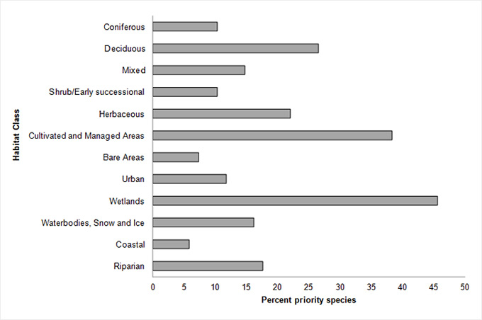
Long description for Figure 3
| Habitat Class | Percent |
|---|---|
| Coniferous | 10 |
| Deciduous | 26 |
| Mixed | 15 |
| Shrub/Early successional | 10 |
| Herbaceous | 22 |
| Cultivated and Managed Areas | 38 |
| Bare Areas | 7 |
| Urban | 12 |
| Wetlands | 46 |
| Waterbodies, Snow and Ice | 16 |
| Coastal | 6 |
| Riparian | 18 |
Note: The total exceeds 100% because each species may be assigned to more than one habitat.
Element 3: Population objectives
Population objectives allow us to measure and evaluate conservation success. The objectives in this strategy are assigned to categories and are based on a quantitative or qualitative assessment of species’ population trends. If the population trend of a species is unknown, the objective is set as “assess and maintain” and a monitoring objective is given. For any species listed under the SARA or under provincial/territorial endangered species legislation, Bird Conservation Strategies defer to population objectives in available Recovery Strategies and Management Plans. The ultimate measure of conservation success will be the extent to which population objectives have been reached over the next 40 years. Population objectives do not currently factor in feasibility of achievement, but are held as a standard against which to measure progress.
Due to the significant presence of species at risk in BCR 13-QC, population objectives relating to species recovery rank first at 21% of all objectives for the region, tying with the “Increase 50%” and “Assess/Maintain” objectives (Fig. 4). The “Maintain current” objective ranks close behind with 16%, while “Increase 100%” is the targeted objective for 12% of the priority species in this BCR. By combining the occurrences of the three categories with population increase objectives or recovery objectives, it is noted that 60% of the priority species identified in BCR 13-QC have been assigned an objective that involves increasing their populations. This reflects the magnitude of the threats affecting bird populations in this BCR.
Overall, 37% of priority species were assigned the objective to maintain populations at current levels; however, for more than half of these species, better population trend data is also necessary for decision-making. Lastly, the objective for the Snow Goose and Canada Goose resident population is to decrease the number of birds present.
Figure 4. Percent of priority species that are associated with each population objective category in BCR 13-QC.
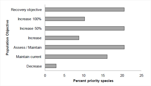
Long description for Figure 4
| Population Objective | Percent |
|---|---|
| Recovery objective | 21 |
| Increase 100 % | 10 |
| Increase 50 % | 21 |
| Increase | 9 |
| Assess / Maintain | 21 |
| Maintain current | 16 |
| Decrease | 3 |
Element 4: Threat assessment for priority species
The threats assessment process identifies threats believed to have a population-level effect on individual priority species. These threats are assigned a relative magnitude (Low, Medium, High, Very High), based on their scope (the proportion of the species’ range within the subregion that is impacted) and severity (the relative impact on the priority species’ population). This allows us to target conservation actions towards threats with the greatest effects on suites of species or in broad habitat classes. Some well-known conservation issues (such as predation by domestic cats or climate change) may not be identified in the literature as significant threats to populations of an individual priority species and therefore may not be captured in the threat assessment. However, they merit attention in conservation strategies because of the large numbers of individual birds affected in many regions of Canada. We have incorporated them in a separate section of the full strategy on Widespread Issues, but, unlike other threats, they are not ranked.
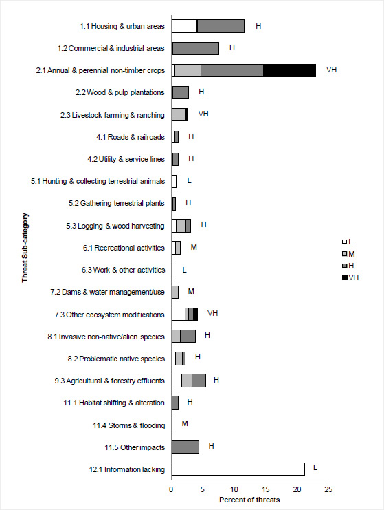
Bird populations found in BCR 13-QC face many threats from different sources. No fewer than 548 threats classified into 10 categories and 21 sub-categories have been addressed and are summarized in Figure 5. Category “2. Agriculture and aquaculture” is the category most frequently associated with priority species in BCR 13-QC because it includes 28% of all threats and has a “Very High” overall relative magnitude (Table 4). Sub-category “2.1 Annual and perennial non-timber crops” alone accounts for 23% of threats; it includes elements such as the conversion of forested farmland to arable land, habitat loss and degradation due to the transition from perennial to annual crops, the intensification of agriculture, and the drainage and filling of wetlands for agricultural purposes. More than three-quarters of the threats in this sub-category have a relative magnitude of “High” or “Very High,” hence its “Very High” overall relative magnitude. Although the conservation issues associated with category 2 have a particular effect on landbirds, they still impact the three other bird groups.
Sub-category “12.1 Information lacking” is the only one identified in category “12. Other direct threats,” and ranks second in terms of the percentage of threats affecting priority species in BCR 13-QC, with 21%. The relative magnitude of all the elements of this conservation issue, as well as the overall relative magnitude of the category, are considered “Low” (Fig. 5; Table 4). This sub-category relates to the lack of biological or demographic information required for appropriate population management. Its magnitude is also attributable to the presence of species at risk for which there are no finalized recovery strategies or management plans. Only 5 of the 22 species at risk in BCR 13-QC had a finalized recovery strategy or management plan when this strategy was written. The need for more information was raised for 44 of the 68 priority species (65%) in BCR 13-QC.
Sub-categories “1.1 Housing and urban areas” and “1.2 Commercial and industrial areas” under category “1. Residential and commercial development” are the next most-common threats at 12% and 8%, respectively (Fig. 5). These sub-categories, which have an overall magnitude of “High,” include threats such as habitat loss and/or degradation due to the drainage and filling of wetlands for residential, commercial or industrial development, loss of woodlands for development, and a decrease in the abundance of prey insects caused by the destruction of wetlands. Overall, category 1 has a “Very High” relative magnitude (Table 4).
Sub-category “9.3 Agricultural and forestry effluents” accounts for 6% of all threats in BCR 13-QC. The only threat associated with this sub-category, and thus with category “9. Pollution”, is the overuse of pesticides, which can cause poisoning, eggshell thinning, and a reduction in prey insect and fish populations. Both sub-category 9.3 and category 9 have a “High” overall relative magnitude for BCR 13-QC (Fig. 5; Table 4).
Category “7. Natural system modifications” is represented by sub-categories “7.2 Dams and water management/use” and “7.3 Other ecosystem modifications” in BCR 13-QC. Although it describes only 5% of all existing threats, this category's overall relative magnitude remains “High” (Table 4). The only threat in sub-category 7.2 is the danger of nest flooding from fluctuations in water levels in the St. Lawrence River as a result of management of the Cornwall Dam. This threat has a relative magnitude of “Medium” and affects mainly waterbirds in wetlands. Sub-category 7.3 results from the abandonment of agricultural land, which then becomes unsuitable for some species of farmland birds, shoreline erosion in riparian areas and the transition from shrub habitats to forest habitats. This sub-category has a “Very High” overall relative magnitude.
Accounting for a little over 5% of threats, category “11. Climate change and severe weather” consists of sub-categories “11.1 Habitat shifting and alterations,” “11.4 Storms and flooding” and “11.5 Other impacts.” The main issues are a higher frequency of adverse weather events that may affect migration, reproductive success, nesting phenology and prey availability as well as changes in the number, size and location of wetlands. These effects are associated with global climate changes, and aerial insectivores such as various species of swallows, the Chimney Swift and the Olive-sided Flycatcher, are particularly affected. Category 11 has a “High” relative magnitude for BCR 13-QC (Table 4), while its sub-categories have relative magnitudes of “Medium” and “High” (Fig. 5).
Other threats, including the colonization of herbaceous and wetland habitats by invasive plant and animal species (sub-category 8.1), and the presence of problematic native species such as the Brown-headed Cowbird (sub-category 8.2), account for 4% and 2% of the conservation issues in BCR 13-QC, respectively. The impacts of logging and wood harvesting (sub-category 5.3), which include forest habitat fragmentation and reduced numbers of snags, large-diameter trees and stands of dead trees, account for approximately 3% of the identified threats. Each of the other sub-categories in Figure 5 represent about 1% of reported threats.
Of the 12 major habitat classes in BCR 13-QC, 9 have been assigned an overall threat magnitude of “High” or “Very High” (Table 4). Cultivated and managed areas as well as wetlands are 2 of the habitat classes most affected by the threats identified in this BCR, with a “Very High” overall relative magnitude. Priority species found in habitats listed under these 2 classes are particularly affected by threats of a “Very High” relative magnitude from agricultural sources (category 2). Birds in cultivated and managed areas are also affected by threats of a “Very High” overall relative magnitude arising from pollution (category 9), while species in wetlands are subjected to impacts of the same magnitude due to residential and commercial development (category 1).
The deciduous, mixed wood, shrub and early successional, herbaceous, urban and riparian habitat classes as well as waterbodies have all been assigned a “High” relative magnitude. For all these habitats, threat categories “1. Residential and commercial development” and “2. Agriculture and aquaculture” have a “High” or “Very High” relative magnitude.
Threat category “4. Transportation and service corridors” particularly affects deciduous as well as shrub and early successional habitats, while category “5. Biological resource use” has a “High” relative magnitude in deciduous and wetland habitats. Lastly, category “7. Natural system modifications” is of a “Very High” relative threat to shrub and early successional habitat, while climate change and severe weather (category 11) have a “High” relative magnitude threatening herbaceous, riparian, urban and wetland habitats as well as in cultivated and managed areas.
Section 2 of the full strategy provides additional details on the threats associated with the various habitat classes. Threats to priority species while they are outside Canada during the non-breeding season were also assessed and are presented in the Threats Outside Canada section of the full strategy.
Figure 5. Percent of identified threats to priority species within BCR 13-QC by threat sub-category.
Note: Each bar represents the percent of the total number of threats identified in each threat sub-category in BCR 13-QC (for example, if 100 threats were identified in total for all priority species in BCR 13-QC, and 10 of those threats were in the category 1.1 Housing and urban areas, the bar on the graph would represent this as 10%). Shading in the bars (VH = very high, H = high, M = medium and L = low) represents the rolled-up magnitude of all threats in each threat sub-category in the BCR.
Long description for Figure 5
| Threat Subcategory | L | M | H | VH |
|---|---|---|---|---|
| 1.1 Housing and urban areas | 4.05 | 0.18 | 7.37 | 0 |
| 1.2 Commercial and industrial areas | 0.37 | 0 | 7.18 | 0 |
| 2.1 Annual and perennial non-timber crops | 0.55 | 4.24 | 9.94 | 8.29 |
| 2.2 Wood and pulp plantations | 0.18 | 0.18 | 2.39 | 0 |
| 2.3 Livestock farming and ranching | 0 | 2.21 | 0 | 0.37 |
| 4.1 Roads and railroads | 0.55 | 0 | 0.55 | 0 |
| 4.2 Utility and service lines | 0.37 | 0 | 0.74 | 0 |
| 5.1 Hunting and collecting terrestrial animals | 0.92 | 0 | 0 | 0 |
| 5.2 Gathering terrestrial plants | 0.18 | 0.18 | 0.37 | 0 |
| 5.3 Logging and wood harvesting | 0.92 | 1.47 | 0.74 | 0 |
| 6.1 Recreational activities | 0.74 | 0.74 | 0 | 0 |
| 6.3 Work and other activities | 0 | 0.18 | 0 | 0 |
| 7.2 Dams and water management/use | 0 | 1.1 | 0 | 0 |
| 7.3 Other ecosystem modifications | 2.21 | 0.55 | 0.74 | 0.74 |
| 8.1 Invasive non-native/alien species | 0.18 | 1.29 | 2.39 | 0 |
| 8.2 Problematic native species | 0.74 | 1.1 | 0.37 | 0 |
| 9.3 Agricultural and forestry effluents | 1.66 | 1.66 | 2.21 | 0 |
| 11.1 Habitat shifting and alteration | 0 | 0 | 1.1 | 0 |
| 11.4 Storms and flooding | 0 | 0 | 0.18 | 0 |
| 11.5 Other impacts | 0 | 0 | 4.42 | 0 |
| 12.1 Information lacking | 21.18 | 0 | 0 | 0 |
Note: Each bar represents the percent of the total number of threats identified in each sub-threat category in BCR 13 QC (for example, if 100 threats were identified in total for all priority species in BCR 13 QC, and 10 of those threats were in the category 1.1 Housing and urban areas, the bar on the graph would represent this as 10%). Shading in the bars (VH = Very High, H = high, M = medium and L = low) represents the rolled up magnitude of all threats in each threat subcategory in the BCR.
Table 4. Relative magnitude of identified threats to priority species within BCR 13-QC by threat category and broad habitat class. Accessible version of Table 4
Element 5: Conservation objectives
Conservation objectives were designed to address threats and information gaps that were identified for priority species. They describe the environmental conditions and research and monitoring that are thought to be necessary for progress towards population objectives and to understand underlying conservation issues for priority bird species. As conservation objectives are reached, they will collectively contribute to achieving population objectives. Whenever possible, conservation objectives were developed to benefit multiple species and/or respond to more than one threat.
Conservation objectives have been divided into the seven categories presented in Figure 6. In BCR-13 QC, a little over half of the suggested conservation objectives are in category “1. Ensure adequate habitat” and affect nearly all habitats in BCR 13-QC, with the exception of bare areas. This objective category includes three sub-categories for BCR 13-QC: “1.1 Ensure land and resource-use policies and practices maintain or improve bird habitat,” “1.2 Maintain the size, shape and configuration of habitat within the natural range of variation” and “1.4 Maintain important bird habitat features on the landscape.”
Objective “7. Improve understanding (of population status, limiting factors and mitigation)” ranks second with 16% of all suggested conservation objectives. The vast majority of objectives in this category are from sub-category “7.1 Improve population/demographic monitoring” and demonstrate a need for increased monitoring in this BCR for many priority species in all four bird groups.
About 15% of the objectives involve managing individual species (category 3). For 22 species at risk in BCR 13-QC, two-thirds of the objectives in this category come from sub-category “3.4 Implement recovery strategies for species at risk.” Sub-categories “3.2 Reduce competition with problematic native species,” “3.3 Reduce parasitism/predation,” “3.5 Prevent and control the spread of invasive and exotic species” and “3.6 Reduce overabundant species” complete this category's objectives.
Objective “2. Reduce mortality/increase productivity” accounts for 10% of the conservation objectives in BCR 13-QC. Half of this category's objectives are associated with the overuse of pesticides in agricultural environments and fall under sub-category “2.1 Reduce mortality and/or sub-lethal effects from pesticide use.” A quarter of this category's objectives relate to incidental mortality from farm operations and fall under sub-category “2.4 Reduce incidental mortality.” The other objectives deal with reducing parasitism and predation (sub-category 2.5), reducing incidental mortality from collisions (sub-category 2.7), and reducing mortality from legal or illegal hunting and persecution (sub-category 2.8).
Categories “6. Manage for climate change” and “4. Reduce disturbance” account for 5% and 2%, respectively, of all the objectives identified for BCR 13-QC. Sub-category “6.2 Manage for habitat resilience as climate changes,” which primarily affects aerial insectivores, is the only sub-category included in category 6. All category 4 threats fall under sub-category “4.1 Reduce disturbance from human recreation” and mostly relate to priority species that are nesting or gathering near waterbodies. No objectives have been assigned to category “5. Ensure adequate food supplies” in BCR 13-QC.
Figure 6. Percent of all conservation objectives assigned to each conservation objective category in BCR 13-QC.
Note: Objective “7. Improve understanding” means improving our understanding of population status, limiting factors and mitigation.
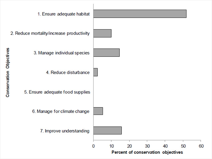
Long description for Figure 6
| Conservation Objective | Percent |
|---|---|
| 1. Ensure adequate habitat | 51.88 |
| 2. Reduce mortality/increase productivity | 10.02 |
| 3. Manage individual species | 14.67 |
| 4. Reduce disturbance | 2.33 |
| 5. Ensure adequate food supplies | 0 |
| 6. Manage for climate change | 5.37 |
| 7. Improve understanding | 15.74 |
Element 6: Recommended actions
Recommended actions indicate on-the-ground activities that will help to achieve the conservation objectives (Fig. 7). Actions are strategic rather than highly detailed and prescriptive. Whenever possible, recommended actions benefit multiple species, and/or respond to more than one threat. Recommended actions defer to or support those provided in recovery documents for species at risk at the federal, provincial or territorial level, but will usually be more general than those developed for individual species.
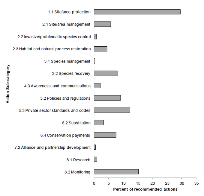
Figure 7 shows that close to 30% of the actions recommended in BCR 13-QC are in sub-category “1.1 Site/area protection.” The high frequency of this recommendation is due to the considerable anthropogenic pressure on bird habitats and populations in a densely populated area, characterized by a wide variety of human activities. The conservation actions most frequently suggested in this category include the protection of major nesting sites, wetlands and large expanses of mature trees through stewardship, by legally designating them as conservation areas and by adopting municipal land use plans that protect wetlands and woodlands. These actions are designed to minimize the impact of threats associated with residential, commercial and agricultural development.
Conservation actions related to additional monitoring needs (sub-category 8.2) rank second and account for 15% of all actions. These actions include specific monitoring measures for certain groups of species, such as nocturnal birds and shorebirds, updating waterfowl banding and survey programs, and improving the migration monitoring program at the McGill Bird Observatory. See “Research and Population Monitoring Needs” in Section 3 of the full strategy for further details.
The adoption of beneficial management practices, mainly in the agriculture and forestry sectors (sub-category 5.3), is the third most-frequently mentioned action sub-category with 12%. More specifically, developing beneficial management practices to reduce incidental bird mortality, implementing silvicultural treatments that maintain natural habitat structure, and supporting sustainable agriculture are some actions suggested for overcoming a number of threats relating to annual and perennial crops, and logging and wood harvesting.
Sub-category “5.2 Policies and regulations” accounts for 9% of the suggested conservation actions and refers primarily to improving the legal protection of wetlands and enforcing legislation. Lastly, implementing conservation payments (sub-category 6.4) accounts for 7% of actions and aims to compensate landowners and farmers for keeping their land uncultivated, preserving farm woodlots and safeguarding pastureland.
More details on suggested conservation actions for the various habitat classes are presented in Section 2 of the full strategy.
Figure 7. Percent of recommended actions assigned to each sub-category in BCR 13-QC.
Note: “Research” and “monitoring” refers to specific species where additional information is required. For a discussion of broad-scale research and monitoring requirements, see the Research and Population Monitoring Needs section in the full strategy.
Long description for Figure 7
| Conservation Action | Percent |
|---|---|
| 1.1 Site/area protection | 29.55 |
| 2.1 Site/area management | 5.74 |
| 2.2 Invasive/problematic species control | 0.87 |
| 2.3 Habitat and natural process restoration | 4.44 |
| 3.1 Species Management | 0.32 |
| 3.2 Species recovery | 7.90 |
| 4.3 Awareness and communications | 2.16 |
| 5.2 Policies and regulations | 9.09 |
| 5.3 Private sector standards and codes | 12.34 |
| 6.2 Substitution | 3.25 |
| 6.4 Conservation payments | 7.58 |
| 7.2 Alliance and partnership development | 0.54 |
| 8.1 Research | 0.97 |
| 8.2 Monitoring | 15.26 |
References
Aboriginal Affairs and Northern Development Canada. 2010. Aboriginal peoples in Quebec. (Accessed 25 July 2012).
Aubry, Y. and R. Cotter. 2007. Quebec’s shorebird conservation plan. Environment and Climate Change Canada, Canadian Wildlife Service - Quebec Region, Sainte-Foy. xvi + 203 p.
Bélanger, L. and M. Grenier. 2002. Agriculture and forest fragmentation: landscape metrics applied to land-use in the St-Lawrence Valley ecoregion. Landscape Ecology 17 : 495-507.
Chapdelaine, G. and J.-F. Rail. 2004. Quebec’s waterbird conservation plan. Migratory Bird Division, Canadian Wildlife Service, Quebec Region, Environment and Climate Change Canada, Sainte-Foy, Quebec. 99 p.
Commission de toponymie Québec. 2012. Banque de noms et de lieux du Québec (in French only) [On line]. (Accessed 25 July 2012).
Donaldson, G. M., C. Hyslop, R. I. G. Morrison, H. L. Dickson, and I. Davidson (editors). 2000. Canadian Shorebird Conservation Plan. Canadian Wildlife Service, Environment and Climate Change Canada, Ottawa, Ontario. 27pp.
Drolet, B., V. Carignan, M.-A. Vaillancourt and G. Falardeau. 2010. Quebec’s landbird conservation plan : volume 1, forest birds. Unpublished document, Environment and Climate Change Canada, Canadian Wildlife Service, Quebec Region, Sainte-Foy, Quebec.
Ecological Stratification Working Group. 1995. A National Ecological Framework for Canada. Agriculture and Agri-Food Canada, Research Branch, Centre for Land and Biological Resources Research and Environment and Climate Change Canada, State of the Environment Directorate, Ecozone Analysis Branch, Ottawa/Hull. Report and national map at 1:7500 000 scale.
Falardeau, G., V. Carignan, B. Drolet and M.-A. Vaillancourt. 2010. Quebec’s landbird conservation plan, volume 2 : birds of agricultural, wetland, urban, arctic, alpine and cliff habitats. Unpublished document, Environment and Climate Change Canada, Canadian Wildlife Service, Quebec Region.
Food and Agriculture Organization (FAO). 2000. Land cover classification system. United Nations Food and Agriculture Organization, Rome.
Gratton, L. 2010. Plan de conservation pour l’écorégion de la vallée du Saint-Laurent et du lac Champlain (PDF; 2.63 Mb) (in French only). La Société canadienne pour la conservation de la nature, région du Québec, Montréal, Québec, Canada. 150 pp.
Jobin, B. and J.-L. DesGranges. 2012. Les amphibiens et les reptiles du Saint-Laurent : la richesse. Environment and Climate Change Canada.
Kennedy, J.A., E.A. Krebs and A.F. Camfield. 2012. A Manual for Completing All-bird Conservation Plans in Canada, April 2012 version. Canadian Wildlife Service, Environment and Climate Change Canada. Ottawa, ON
Lepage, C., D. Bordage, D. Dauphin, F. Bolduc and B. Audet. In prep. Plan de conservation de la sauvagine du Quebec, 2010. Environnement et Changement climatique Canada, Canadian Wildlife Service, Quebec Region du Québec, Québec.
Li, T. and J.-P. Ducruc. 1999. Les provinces naturelles. Niveau I du cadre écologique de référence du Québec (in French only). Ministère de l’Environnement. [On line] (Accessed 25 July 2012).
Milko, R., L. Dickson, R. Elliot, and G. Donaldson. 2003. Wings Over Water: Canada’s Waterbird Conservation Plan. Canadian Wildlife Service, Environment and Climate Change Canada, Ottawa, Ontario. 28pp.
Ministère des Affaires municipales des Régions et de l'Occupation du territoire. 2010. Répertoire des municipalités (in French only) [On line]. (Accessed 25 July 2012)
Ministère des Ressources naturelles. 2013. Zones de végétation et domaines bioclimatiques du Québec (in French only) [On line]. (Accessed 28 February 2013).
Ministère du Développement durable, de l’Environnement, de la Faune et des Parcs. 2013. Liste des espèces désignées menacées ou vulnérables au Québec (in French only) [On line]. (Accessed 4 April 2013)
North American Waterfowl Management Plan, Plan Committee. 2004. North American Waterfowl Management Plan 2004. Implementation Framework: Strengthening the Biological Foundation. Canadian Wildlife Service, U.S. Fish and Wildlife Service, Secretaria de Medio Ambiente y Recursos Naturales, 106pp.
Panjabi, A. O., E. H. Dunn, P. J. Blancher, W. C. Hunter, B. Altman, J. Bart, C. J. Beardmore, H. Berlanga, G. S. Butcher, S. K. Davis, D. W. Demarest, R. Dettmers, W. Easton, H. Gomez de Silva Garza, E. E. Iñigo-Elias, D. N. Pashley, C. J. Ralph, T. D. Rich, K. V. Rosenberg, C. M. Rustay, J. M. Ruth, J. S. Wendt, and T. C. Will. 2005. The Partners in Flight Handbook on Species Assessment. Version 2005. Partners in Flight Technical Series No. 3. Rocky Mountain Bird Observatory (PDF; 405 Kb)
Rich, T.D., C.J. Beardmore, H. Berlanga, P.J. Blancher, M.S.W. Bradstreet, G.S. Butcher, D.W. Demarest, E.H. Dunn, W.C. Hunter, E.E. Iñigo-Elias, J.A. Kennedy, A.M. Martell, A.O. Panjabi, D.N. Pashley, K.V. Rosenberg, C.M. Rustay, J.S. Wendt, T.C. Will. 2004. Partners in Flight North American Landbird Conservation Plan. Cornell Lab of Ornithology. Ithaca, NY.
Species at Risk Public Registry. Accessed 4 April 2012. Schedule 1: List of Wildlife Species at Risk.
Statistics Canada. 2010a. Table 1: St. Lawrence Lowlands Ecoregion. [On line]. (Accessed 26 July 2012).
Statistics Canada. 2010b. Population and dwelling counts, for Canada, provinces and territories, and federal electoral districts (2003 Representation Order), 2011 and 2006 censuses [On line].
Statistics Canada. 2012. Dwelling counts, for Canada, provinces and territories, and census subdivisions (municipalities), 2011 and 2006 censuses [On line]. (Accessed 26 July 2012).