
Bird Conservation Strategy for region 3 in the Prairies and Northern Region
- Abridged Version -
June 2013
The abridged version of the strategy available here contains a summary of the results, but does not include an analysis of conservation needs by habitat, a discussion of widespread conservation issues, or the identification of research and monitoring needs.
Other formats available for this document:
Table of contents
Preface
Environment and Climate Change Canada led the development of all-bird conservation strategies in each of Canada's Bird Conservation Regions (BCRs) by drafting new strategies and integrating new and existing strategies into an all-bird framework. These integrated all-bird conservation strategies will serve as a basis for implementing bird conservation across Canada, and will also guide Canadian support for conservation work in other countries important to Canada's migrant birds. Input to the strategies from Environment and Climate Change Canada's conservation partners is as essential as their collaboration in implementing their recommendations.
Environment and Climate Change Canada has developed national standards for strategies to ensure consistency of approach across BCRs. Bird Conservation Strategies will provide the context from which specific implementation plans can be developed for each BCR, building on the programs currently in place through Joint Ventures or other partnerships. Landowners including Aboriginal peoples will be consulted prior to implementation.
Conservation objectives and recommended actions from the conservation strategies will be used as the biological basis to develop guidelines and beneficial management practices that support compliance with regulations under the Migratory Birds Convention Act, 1994.
Acknowledgements
Paul Smith, Vicky Johnston and Craig Machtans were the main authors of this document, which follows templates developed by Alaine Camfield, Judith Kennedy and Elsie Krebs with the help of the BCR planners in each of the Canadian Wildlife Service regions throughout Canada. However, work of this scope cannot be accomplished without the contribution of other colleagues who provided or validated technical information, commented on earlier draft versions of the strategy and supported the planning process. We would like to thank the following people: Kathy Dickson, Lynne Dickson, Garry Donaldson, Dave Duncan, Tony Gaston, Grant Gilchrist, Jim Leafloor, Josée Lefebvre, Mark Mallory, Erica Nol, Myra Robertson, Jennie Rausch, Pam Sinclair and Samantha Song.
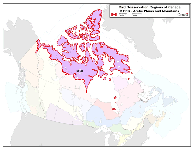
Long description for Map
Map of the Bird Conservation Regions (BCR's) of Canada with BCR 3, Prairie and Northern Region: Arctic Plains and Mountains highlighted. Canada (with Alaska, Greenland and the northern portion of the United States of America also appearing) is shown, as it is only present to provide context for the location of the highlighted BCR 3. The Canadian map is divided by BCR (12 Canadian BCRs in total), shown differently, and their exact locations and sizes are indistinguishable, aside from BCR 3.
The highlighted BCR 3 covers an area from the treeline to the northernmost tip of Ellesmere Island and spans the breadth of the continent from the North Slope of Alaska to the Atlantic coast of Labrador. Within Canada, the majority of BCR 3 falls within Nunavut and the Northwest Territories. The following legend appears in the top right corner of the map: “Bird Conservation Regions of Canada. 3 PNR - Arctic Plains and Mountains” and includes the Environment and Climate Change Canada logo, and the Government of Canada logo.
Executive summary
Bird Conservation Region (BCR) 3, Arctic Plains and Mountains, covers an area of more than 2 900 000km2 and spans the continent from Alaska to Labrador. The habitats within this area are varied, from sparse taiga forests at the treeline, to wet coastal meadows of sedges and grasses, to gravel barrens and glaciers. The majority of this BCR falls within Nunavut and the Northwest Territories, with smaller portions in Quebec, Labrador and the Yukon. This strategy covers all of BCR 3 contained within Environment and Climate Change Canada's Prairie and Northern Region, the small portion in the Yukon, and the five associated marine ecoregions. We refer to this area as BCR 3 PNR.
These conservation strategies serve as a framework for implementing bird conservation nationally and also identify international conservation issues for Canada's priority birds. Objective and replicable methods were used to identify priority species, define habitat associations, set population targets, assess and rank threats, set conservation objectives, and address these objectives with conservation actions. This strategy is not intended to be highly prescriptive, but rather is intended to guide future implementation efforts undertaken by various partners and stakeholders.
We evaluated 159 species of birds that occur in the terrestrial and marine habitats of BCR 3 PNR, and determined that 65 met the criteria for priority status. More than 70% of these species used wetland habitats, although shrub habitats (especially heath tundra), bare areas (including a variety of coastal habitats, gravel barrens and cliffs) and aquatic habitats (freshwater and marine) were also important.
Population objectives were set on the basis of observed trends; however, inadequate monitoring information was a pervasive issue: we were unable to assign a quantitative population objective for 34% of the priority species. For 35% of priority species, there was sufficient evidence of declines that we recommend increasing the population size. Management for a majority of species would be improved with better information on population size, trend and range. Recommendations are made for the priority species most in need of improved monitoring.
The threats assessment identified many activities or issues potentially causing harm to BCR 3 PNR's priority birds. Given the limited footprint of development in the region and the migratory habits of almost all arctic-breeding birds, a majority of these threats are outside of the BCR. Pollution, habitat loss and degradation, and legal and illegal hunting (primarily outside of North America) are among the most important threats. Even within the BCR, some of the most important threats stem indirectly from human activities elsewhere; issues such as anthropogenic climate change, degradation of tundra habitats from abundant waterfowl (a result of southern land-use changes), and long-range transport and deposition of contaminants all negatively impact arctic wildlife but are not caused by activities in the North.
Conservation actions are recommended to address threats both within and outside BCR 3 PNR. Within the BCR, many recommended actions relate to law and policy, including continued enforcement of existing regulations, development of new regulations or beneficial management practices, and strengthening of legislation. Actions involving direct management or protection of species or habitats were recommended in fewer cases because such direct management would be difficult to achieve on the scale required for such a large planning unit. For some issues, it was determined that additional research, monitoring or other information could increase our ability to address threats. Suggestions to acquire this information are provided.
Introduction: Bird Conservation Strategies
Context
This document is one of a suite of Bird Conservation Region Strategies (BCR strategies) that have been drafted by Environment and Climate Change Canada for all regions of Canada. These strategies respond to Environment and Climate Change Canada's need for integrated and clearly articulated bird conservation priorities to support the implementation of Canada's migratory birds program, both domestically and internationally. This suite of strategies builds on existing conservation plans for the four “bird groups” (waterfowl, Footnote1waterbirds, Footnote2shorebirds Footnote3 and landbirds Footnote4) in most regions of Canada, as well as on national and continental plans, and includes birds under provincial/territorial jurisdiction. These new strategies also establish standard conservation planning methods across Canada, and fill gaps, as previous regional plans do not cover all areas of Canada or all bird groups.
These strategies present a compendium of required actions based on the general philosophy of achieving scientifically based desired population levels as promoted by the four pillar initiatives of bird conservation. Desired population levels are not necessarily the same as minimum viable or sustainable populations, but represent the state of the habitat/landscape at a time prior to recent dramatic population declines in many species from threats known and unknown. The threats identified in these strategies were compiled using currently available scientific information and expert opinion. The corresponding conservation objectives and actions will contribute to stabilizing populations at desired levels.
The BCR strategies are not highly prescriptive. In most cases, practitioners will need to consult additional information sources at local scales to provide sufficient detail to implement the recommendations of the strategies. Tools such as beneficial management practices will also be helpful in guiding implementation. Partners interested in participating in the implementation of these strategies, such as those involved in the habitat Joint Ventures established under the North American Waterfowl Management Plan, are familiar with the type of detailed implementation planning required to coordinate and undertake on-the-ground activities.
Strategy Structure
Section 1 of this strategy, published here, presents general information about the BCR and the subregion, with an overview of the six elements Footnote5 that provide a summary of the state of bird conservation at the sub-regional level. Section 2, included in the full version of the strategy, provides more detail on the threats, objectives and actions for priority species grouped by each of the broad habitat types in the subregion. Section 3, also part of the full strategy, presents additional widespread conservation issues that are not specific to a particular habitat or were not captured by the threat assessment for individual species, as well as research and monitoring needs, and threats to migratory birds while they are outside of Canada. The approach and methodology are summarized in the appendices of the full strategy, but details are available in a separate document (Kennedy et al. 2012). A national database houses all the underlying information summarized in this strategy and is available from Environment and Climate Change Canada.
Characteristics of Bird Conservation Region 3
BCR 3 covers an area from the treeline to the northernmost tip of Ellesmere Island (Figures. 1a,b), and spans the breadth of the continent from the North Slope of Alaska to the Atlantic coast of Labrador. It encompasses an area of more than 2 900 000 km2. Within Canada, a majority of BCR 3 falls within Nunavut and the Northwest Territories, and is therefore within the boundaries of Environment and Climate Change Canada's Prairie and Northern Region (PNR). In addition, five marine ecoregions are associated with BCR 3 PNR: Hudson Bay Complex, Arctic Basin, Eastern Arctic (Lancaster Sound, Baffin Bay - Davis Strait), Arctic Archipelago and Western Arctic (Beaufort-Amundsen-Viscount-Melville-Queen Maud; see Fisheries and Oceans Canada 2009). The North Slope of the Yukon falls within BCR 3 and is considered here; however, the portions of BCR 3 within Quebec and Labrador are considered in separate conservation strategies.
Habitats within this vast area are diverse, but all are influenced by a short growing season and continuous permafrost. The northeast portion of the region is mountainous, with unvegetated, barren rock and glaciers predominating (Figures 1a,b). Elsewhere in the High Arctic, ground cover is often sparse and in drier areas is dominated by herbs, lichens and dwarf shrubs. At these latitudes, many of the key habitats for birds are marine (Figures 2a,b). Low-lying wetlands of grasses, sedges and mosses are not widespread but offer important bird habitat where they occur. These wetlands are more common at mid- and low-arctic latitudes, and some areas such as the Great Plain of the Koukdjuak or the Mackenzie Delta offer large expanses of comparatively rich tundra wetlands; these wetlands figure prominently in the network of protected areas and key sites in the region (Figures 2a,b). Surface water is extensive, and areas of patterned ground are common. Upland habitats at mid- and low-arctic latitudes range from heavily vegetated heath communities to sparse “cryptobiotic crusts” of cyanobacteria, lichens and moss. Shrubs, especially willows, are taller at lower latitudes. At the southern fringe of BCR 3 PNR, small spruce trees are found in sheltered areas; these restricted patches of taiga (i.e., coniferous) habitat are home to a number of species not found elsewhere in the BCR.
Bird diversity in this vast area is low in comparison to more temperate latitudes. Still, a large number of species are reliant on the marine and terrestrial habitats of BCR 3 PNR. In terms of number of species, the bird community is dominated by shorebirds, waterbirds and waterfowl. Although numerous landbirds are found here, few species have their range centred in the Canadian Arctic. This pattern holds across the circumpolar Arctic, where 108 of 162 Arctic specialist species are from the Orders Charadriiformes and Anseriformes (especially from families Scolopacidae [sandpipers and allies, Laridae (gulls) and Alcidae [auks] and subfamilies Mergini [sea ducks] and Anserini [geese]; Gantner and Gaston in prep.).
A small number of species remain in BCR 3 during the non-breeding season, travelling only as far as is necessary to find food. Some seaducks and seabirds migrate east or west to winter in high-latitude marine environments. Some shorebirds and Brant breeding in the High Arctic winter in northern Europe. However, the vast majority of species migrate south, including many shorebirds that travel thousands of kilometres to winter in Central and South America.
These long-range migrations expose arctic-breeding species to a variety of risks throughout the annual cycle. Identifying these risks, both within and outside BCR 3 PNR, is a focus of this conservation strategy.
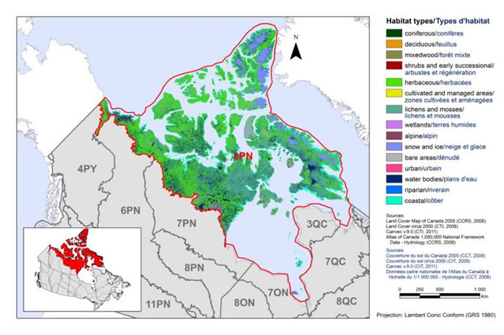
Long description for Figure 1a
Map of the landcover in BCR 3 Prairie and Northern Region: Arctic Plains and Mountains. The map's extent includes Alaska, western Greenland, and most of Canada except for southern Ontario, southern Quebec and the Maritimes. The borders of BCR 3QC, 4PY, 6PN, 7PN, 8PN, 7ON, 8ON, 7QC, 8QC and 11PN are delineated. Inset in the lower left corner is a map of Canada with BCR 3 highlighted.
BCR 3 covers an area from the treeline to the northernmost tip of Ellesmere Island and spans the breadth of the continent from the North Slope of Alaska to the Atlantic coast of Labrador. Within Canada, the majority of BCR 3 falls within Nunavut and the Northwest Territories.
The various habitat types that exist in the BCR are shown on the map, which are explained in the following bilingual legend (appearing to the right of the map):
- Coniferous/conifères
- Deciduous/feuillus
- Mixedwood/forêt mixte
- Shrubs and early successional/arbustes et regeneration
- Herbaceous/herbacées
- Cultivated and managed areas/zone cultivées et aménagées
- Lichens and mosses/lichens et mousses
- Wetlands/terres humides
- Alpine/alpin
- Snow and ice/neige et glace
- Bare areas/denude
- Urban/urbain
- Water bodies /plans d'eau
- Riparian/riverain
- Coastal/côtier
The most common habitat types visible at this scale in BCR 3 are herbaceous and coastal throughout, followed by waterbodies/snow/ice in moderate concentrations. The glaciers are on Baffin Island and in the northern most portion of the BCR. The other habitat types are not visible at this scale.
The remaining text in the legend is the following: Sources: Land Cover Map of Canada 2005 (CCRS, 2008), Land Cover circa 2000 (CIT, 2009), Canvec v 9.0 (CIT, 2011), Atlas of Canada 1,000,000 National Framework Data - Hydrology (CCRS, 2008). Sources: Couverture du sol du Canada 2005 (CCT, 2008), Couverture du sol circa 2000 (CIT, 2009), Canvec v 9.0 (CIT, 2011), Données-cadre nationales de l'Atlas du Canada à l'échelle du 1/1 000 000 - Hydrologie (CCT, 2008). There is also a visual representation of scale for the map in the legend which indicates 0, 250, 500 and 1000 kms. The Projection is Lambert Conic Conform (GRS 1980).
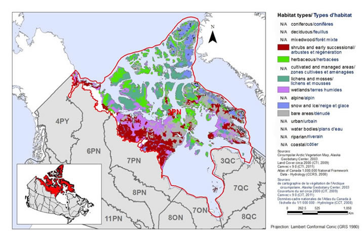
Long description for Figure 1b
Map of the landcover in BCR 3 Prairie and Northern Region: Arctic Plains and Mountains with an emphasis on the variation in arctic vegetation. The map's extent includes Alaska, western Greenland, and most of Canada except for southern Ontario, southern Quebec and the Maritimes. The borders of BCR 3QC, 4PY, 6PN, 7PN, 8PN, 7ON, 8ON, 7QC, 8QC and 11PN are delineated. Inset in the lower left corner is a map of Canada with BCR 3 highlighted.
BCR 3 covers an area from the treeline to the northernmost tip of Ellesmere Island and spans the breadth of the continent from the North Slope of Alaska to the Atlantic coast of Labrador. Within Canada, the majority of BCR 3 falls within Nunavut and the Northwest Territories.
The various habitat types that could exist in the BCR are listed in the bilingual legend (appearing to the right of the map), but only those that appear have been associated with them (denoted below by a *):
- Coniferous/conifères
- Deciduous/feuillus
- Mixedwood/forêt mixte
- *Shrubs and early successional/arbustes et regeneration
- *Herbaceous/herbacées
- Cultivated and managed areas/zone cultivées et aménagées
- *Lichens and mosses/lichens et mousses
- *Wetlands/terres humides
- Alpine/alpin
- *Snow and ice/neige et glace
- *Bare areas/denude
- Urban/urbain
- Water bodies /plans d'eau
- Riparian/riverain
- Coastal/côtier
Snow and ice, herbaceous, wetlands and schrubs seem to appear in more or less the same proportions in the BCR. Shrubs occur predominantly along the southern border, wetlands appear just north of the latter, herbaceous habitats mostly on the islands in the middle of the BCR and the snow and ice is mostly in the north.
The remaining text in the legend is the following: Sources: Circumpolar Arctic Vegetation Map, Alaska Geobotany Center, 2003; Land Cover circa 2000 (CIT, 2009), Canvec v 9.0 (CIT, 2011), Atlas of Canada 1,000,000 National Framework Data - Hydrology (CCRS, 2008). Sources: cartographie de la végétation de l'Arctique circumpolaire, Alaska Geobotany Center, 2003;, Couverture du sol circa 2000 (CIT, 2009), Canvec v 9.0 (CIT, 2011), Données-cadre nationales de l'Atlas du Canada à l'échelle du 1/1 000 000 - Hydrologie (CCT, 2008). There is also a visual representation of scale for the map in the legend which indicates 0, 262.5, 525 and 1050 kms. The Projection is Lambert Conformal Conic (GRS 1980).
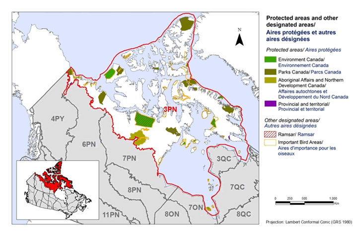
Long description for Figure 2a
Map of protected and other designated areas in BCR 3 Prairie and Northern Region: Arctic Plains and Mountains. The map's extent includes Alaska, western Greenland, and most of Canada except for southern Ontario, southern Quebec and the Maritimes. The borders of BCR 3QC, 4PY, 6PN, 7PN, 8PN, 7ON, 8ON, 7QC, 8QC and 11PN are delineated. Inset in the lower left corner is a map of Canada with BCR 3 highlighted.
BCR 3 covers an area from the treeline to the northernmost tip of Ellesmere Island and spans the breadth of the continent from the North Slope of Alaska to the Atlantic coast of Labrador. Within Canada, the majority of BCR 3 falls within Nunavut and the Northwest Territories.
The various types of protected areas that exist in the BCR are shown on the map, which are explained in the following bilingual legend (appearing to the right of the map):
Protected areas/Aires protégées
- Environment and Climate Change Canada/Environnement et Changement climatique Canada
- Parks Canada/Parcs Canada
- Aboriginal Affairs and Northern Development Canada/Affaires autochtones et Développement du Nord Canada
- Provincial/Provincial
Other designated areas/Autres aires designées
- Important Bird Areas/Aires d'importance pour les oiseaux
- Ramsar/Ramsar
The most common type of protected area shown is Parks Canada, followed by Environment and Climate Change Canada and Aboriginal Affairs/Northern Development. All of these areas are in large chunks, few in number and occur throughout the BCR. There are also many important bird areas visible at this scale.
There is also a visual representation of scale for the map in the legend which indicates There is also a visual representation of scale for the map in the legend which indicates 0, 250, 500 and 1000 kms. The Projection is Lambert Conic Conform (GRS 1980).
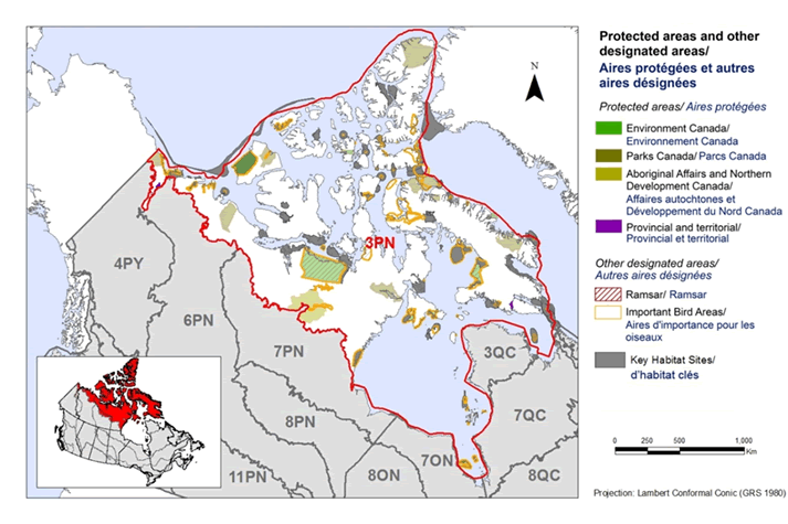
Long description for Figure 2b
Map of protected and other designated areas in BCR 3 Prairie and Northern Region: Arctic Plains and Mountains, including areas considered by Environment and Climate Change Canada to be Key Habitat Sites for migratory birds, including those with no formal protection. The areas from the previous map were made partially transparent so that overlap of key areas and protected areas would be visible. The map's extent includes Alaska, western Greenland, and most of Canada except for southern Ontario, southern Quebec and the Maritimes. The borders of BCR 3QC, 4PY, 6PN, 7PN, 8PN, 7ON, 8ON, 7QC, 8QC and 11PN are delineated. Inset in the lower left corner is a map of Canada with BCR 3 highlighted.
BCR 3 covers an area from the treeline to the northernmost tip of Ellesmere Island and spans the breadth of the continent from the North Slope of Alaska to the Atlantic coast of Labrador. Within Canada, the majority of BCR 3 falls within Nunavut and the Northwest Territories. The various types of protected areas that exist in the BCR are shown on the map, which are explained in the following bilingual legend (appearing to the right of the map):
Protected areas/Aires protégées
- Environment and Climate Change Canada/Environnement et Changement climatique Canada
- Parks Canada/Parcs Canada
- Aboriginal Affairs and Northern Development Canada/Affaires autochtones et Développement du Nord Canada
- Provincial/Provincial
Other designated areas/Autres aires designées
- Important Bird Areas/Aires d'importance pour les oiseaux
- Ramsar/Ramsar
- Key habitat sites/d'habitat clés
The same protected and designated areas from the previous map appear here, along with many key habitat sites, shown. The latter appear throughout the BCR in smaller patches. There is also a visual representation of scale for the map in the legend which indicates 0, 250, 500 and 1000 kms. The Projection is Lambert Conic Conform (GRS 1980).
Section 1: Summary of results - All Birds, All Habitats
Element 1: Priority species assessment
These Bird Conservation Strategies identify “priority species” from all regularly occurring bird species in each BCR subregion. Species that are vulnerable due to population size, distribution, population trend, abundance and threats are included because of their “conservation concern”. Some widely distributed and abundant “stewardship” species are also included. Stewardship species are included because they typify the national or regional avifauna and/or because they have a large proportion of their range and/or continental population in the subregion; many of these species have some conservation concern, while others may not require specific conservation effort at this time. Species of management concern are also included as priority species when they are at (or above) their desired population objectives but require ongoing management because of their socio-economic importance as game species or because of their impacts on other species or habitats.
The purpose of the prioritization exercise is to focus implementation efforts on the issues of greatest significance for Canadian avifauna. Table 1 provides a full list of all priority species and their reason for inclusion. Tables 2 and 3 summarize the number of priority species in BCR 3 PNR by bird group and by the reason for priority status.
Across all bird groups, 65 of 159 (41%) species/populations were designated as priority taxa (Table 1 and 2). A large fraction of the candidate species, especially for landbirds, did not merit priority status because their populations are concentrated outside of the Arctic. For landbirds, for example, 43/62 species (69%) were estimated to have ≤10% of their range within BCR 3. For shorebirds and waterfowl, bird groups with many arctic specialist species, >50% of candidate species were assigned priority status (Table 2). Nine arctic species are formally assessed as “at risk” by the Committee on the Status of Endangered Wildlife in Canada (COSEWIC) or listed under the Species at Risk Act (SARA; Table 3). The vast majority of species were assigned priority status based on concern over population size or trend, or threats that they face throughout the year.
Table 1. Priority species in BCR 3 PNR, population objectives, and the reasons for priority status. Accessible Version of Table 1.
| Bird group | Total species | Total priority species | Percent listed as priority | Percent of priority list |
|---|---|---|---|---|
| Landbird | 62 | 17 | 27% | 26% |
| Shorebird | 31 | 19 | 61% | 29% |
| Waterbird | 28 | 8 | 29% | 12% |
| Waterfowl | 38 | 21 | 55% | 32% |
| All | 159 | 65 | 41% | 100% |
| Reason for priority listinga | Landbirds | Shorebirds | Waterbirds | Waterfowl |
|---|---|---|---|---|
| COSEWICb | 3 | 3 | 2 | 1 |
| Federal SARA Listedc | 3 | 3 | 2 | 1 |
| NAWMPd | - | - | - | 21 |
| National/Continental Concern | 4 | 16 | 8 | - |
| Regional Concern | 2 | - | - | - |
| National/Continental Stewardship | 8 | - | - | - |
| Regional Stewardship | 7 | - | - | - |
| Expert Review | 4 | 3 | - | - |
a A single species can be on the priority list for more than one reason. Note that not all reasons for inclusion apply to every bird group (indicated by “-”).
b COSEWIC indicates species assessed by the Committee on the Status of Endangered Wildlife in Canada as Endangered, Threatened, or Special Concern.
c Species listed on Schedule 1 of the Species at Risk Act as Endangered; Threatened; or Special Concern.
d NAWMP indicates species ranked in the North American Waterfowl Management Plan (NAWMP 2004) as having Moderately High, High or Highest breeding or non-breeding conservation and/or monitoring need in the WCR.
Element 2: Habitats important to priority species
Identifying the broad habitat requirements for each priority species within the BCR allowed species to be grouped by shared habitat-based conservation issues and actions. If many priority species associated with the same habitat face similar conservation issues, then conservation action in that habitat may support populations of several priority species. BCR strategies use a modified version of the standard land cover classes developed by the United Nations (Food and Agriculture Organization 2000) to categorize habitats, and species were often assigned to more than one habitat class.
Wetland habitats were used by 72% of priority species, and nearly half of all priority species used three additional habitat categories: shrub/early successional (shrub tundra, including both willow and heath habitat types), bare areas (e.g., rocky coasts or cliffs) or waterbodies, snow and ice (freshwater or marine; Figure 3). Habitats were further defined on the basis of their location; nearly half of the priority species used habitats that were located in coastal areas, while few species were found in alpine habitats. Taiga (i.e., coniferous) habitats, although uncommon in BCR 3 PNR, were used by 8% of priority species.
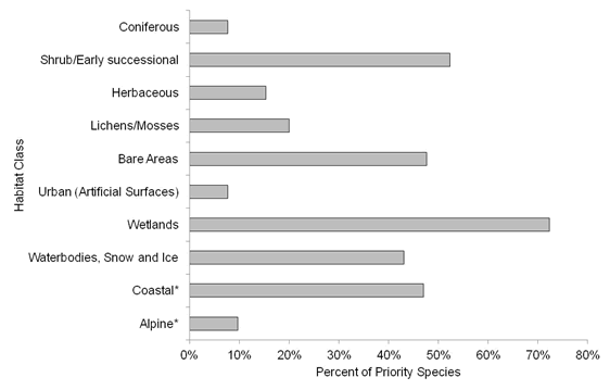
Long description for Figure 3
A horizontal bar graph indicating the percent of priority species (x axis) that are associated with each habitat type (y axis, coniferous, shrub/early successional, herbaceous, lichens/mosses, bare areas, urban, wetlands, waterbodies/snow/ice, coastal and alpine) in BCR 3 Prairie and Northern region. Note: The total exceeds 100% because each species may be assigned to more than one habitat.
| Habitat class | Percent of Priority Species |
|---|---|
| Coniferous | 8 |
| Shrub/Early Successional | 52 |
| Herbaceous | 15 |
| Lichens/Mosses | 20 |
| Bare Areas | 48 |
| Urban | 8 |
| Wetlands | 72 |
| Waterbodies, Snow and Ice | 43 |
| Coastal | 47 |
| Alpine | 10 |
Element 3: Population objectives
Population objectives allow us to measure and evaluate conservation success. The objectives in this strategy are assigned to categories and are based on a quantitative or qualitative assessment of species' population trends. If the population trend of a species is unknown, the objective is set as “assess and maintain”, and a monitoring objective is given. For any species listed under SARA or under provincial/territorial endangered species legislation, Bird Conservation Strategies defer to population objectives in available Recovery Strategies and Management Plans. The ultimate measure of conservation success will be the extent to which population objectives have been reached over the next 40 years. Population objectives do not currently factor in feasibility of achievement, but are held as a standard against which to measure progress.
In BCR 3 PNR, incomplete monitoring information (leading to unknown trends) resulted in 22 species (34%) being assigned an objective of “assess/maintain” the population (Figure 4). Although the lack of detailed monitoring data was a pervasive issue, for 23 (35%) species, evidence for declines was sufficient to make recommendations for increasing population size. Methods are described in Kennedy et al. (2012), but in general, species with large, documented declines were assigned an objective of 100% population increase, whereas those with small or possible declines were assigned an objective of 50% increase. Four populations of white geese are considered to be above their population objectives, and objectives of decreasing current population size were assigned. An additional four species (Ivory Gull, Ross's Gull, Red Knot rufa and Eskimo Curlew), are listed under SARA as species at risk, and therefore their population objectives are or will be defined in recovery documents.
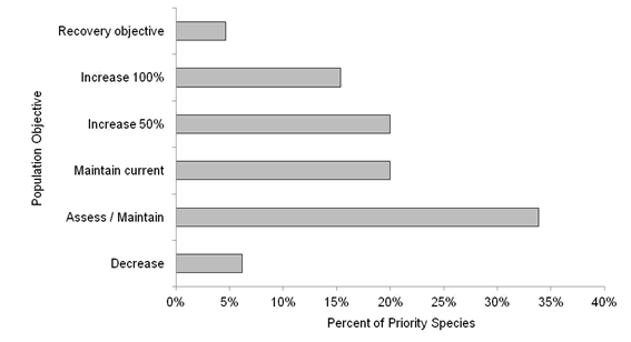
Long description for Figure 4
A horizontal bar graph indicating the percent of priority species (x axis) that are associated with each population objective (y axis; increase 100%, increase 50%, assess/maintain, maintain current, recovery objective, decrease) in BCR 3 Prairie and Northern Region.
| Population Objective | Percent of Priority Species |
|---|---|
| Recovery Objectives | 5 |
| Increase 100% | 15 |
| Increase 50% | 20 |
| Maintain current | 20 |
| Assess / Maintain | 34 |
| Decrease | 6 |
Element 4: Threat assessment for priority species
The threat assessment process identifies threats believed to have a population-level effect on individual priority species. These threats are assigned a relative magnitude (Low, Medium, High, Very High), based on their scope (the proportion of the species' range within the subregion that is impacted) and severity (the relative impact on the priority species' population). This allows us to target conservation actions towards threats with the greatest effects on suites of species or in broad habitat classes. Some well-known conservation issues (such as predation by domestic cats or climate change) may not be identified in the literature as significant threats to populations of an individual priority species and therefore may not be captured in the threat assessment. However, they merit attention in conservation strategies because of the large numbers of individual birds affected in many regions of Canada. We have incorporated them in a separate section on Widespread Issues in the full strategy, but, unlike other threats, they are not ranked.
Because of sparse human settlement and limited development in BCR 3 PNR, the dominant threats to priority bird populations differ from those in most other parts of the country. Development has a limited footprint, and agriculture is non-existent. Resource extraction does impact priority birds, but because such activities are on a localized scale, effects are estimated to be low at the population level (Figure 5). Similarly, harvest and bycatch of priority birds have low impacts on any one population, and are considered a threat of low magnitude overall (Table 4) despite influencing a number of priority species. Among the most important threats to priority birds in BCR 3 are issues that stem indirectly from human activities elsewhere. Issues such as anthropogenic climate change, degradation of tundra habitats from abundant waterfowl (a result of southern land-use changes) and deposition of contaminants transported over long ranges all negatively impact arctic wildlife but have little to do with activities in the North.
It is perhaps not surprising then that a majority of the significant threats to BCR 3 PNR's priority species occur outside of the BCR. While outside the BCR, the Arctic's priority birds are exposed to a diversity of threats including pollution, legal and illegal hunting, and development. These and other threats occurring outside of Canada are discussed in a section of the full strategy.
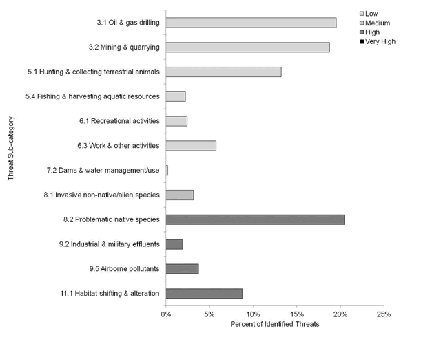
Long description for Figure 5
A horizontal bar graph indicating the percent of identified threats to priority species (x axis) within BCR 3 Prairie and Northern Region by threat subcategory (y axis; i.e. Recreational Activities, Airborne pollutants, etc.).
Each bar represents the percent of the total number of threats identified in each sub-threat category in BCR 3 (for example, if 100 threats were identified in total for all priority species in BCR 3, and 10 of those threats were in the category 1.1 Housing and urban areas, the bar on the graph would represent this as 10%). Shading in the bars (VH = very high, H = high, M = medium and L = low) represents the rolled up magnitude of all threats in each threat subcategory in the BCR
| Threat Sub-category | Low | Medium | High | Very High |
|---|---|---|---|---|
| 3.1 Oil and gas drilling | 19.5 | 0.0 | 0.0 | 0.0 |
| 3.2 Mining and quarrying | 18.8 | 0.0 | 0.0 | 0.0 |
| 5.1 Hunting and collecting terrestrial animals | 13,2 | 0.0 | 0.0 | 0.0 |
| 5.4 Fishing and harvesting aquatic resources | 2,2 | 0.0 | 0.0 | 0.0 |
| 6.1 Recreational activities | 2.4 | 0.0 | 0.0 | 0.0 |
| 6.3 Work and other activities | 5.8 | 0.0 | 0.0 | 0.0 |
| 7.2 Dams and water management/use | 0,2 | 0.0 | 0.0 | 0.0 |
| 8.1 Invasive non-native/alien species | 0.0 | 3,2 | 0.0 | 0.0 |
| 8.2 Problematic native species | 0.0 | 0.0 | 20.5 | 0.0 |
| 9.2 Industrial and military effluents | 0.0 | 0.0 | 1.9 | 0.0 |
| 9.5 Airborne pollutants | 0.0 | 0.0 | 3.7 | 0.0 |
| 11.1 Habitat shifting and alteration | 0.0 | 0.0 | 8.7 | 0.0 |
| Threat category | Coniferous | Shrub/Early successional | Herbaceous | Lichens/Mosses | Bare areas | Artificial surfaces | Wetlands | Waterbodies, snow and ice | Overall |
|---|---|---|---|---|---|---|---|---|---|
| Overall | L | M | M | L | M | L | H | H | - |
| 1. Residential and Commercial Development | - | - | - | - | - | - | - | - | - |
| 2. Agriculture and aquaculture | - | - | - | - | - | - | - | - | - |
| 3. Energy production and mining | L | L | L | L | L | L | L | L | L |
| 4. Transportation and service corridors | - | - | - | - | - | - | - | - | - |
| 5. Biological resource use | - | L | L | L | L | - | L | L | L |
| 6. Human intrusions and disturbance | - | L | L | L | L | L | L | L | L |
| 7. Natural system modifications | - | - | - | - | - | - | - | L | L |
| 8. Invasive and other problematic species and genes | L | H | H | M | L | L | H | M | H |
| 9. Pollution | - | L | L | - | H | L | L | H | H |
| 11. Climate change and severe weather | L | M | M | - | M | - | H | H | H |
Element 5: Conservation objectives
Conservation objectives were designed to address threats and information gaps that were identified for priority species. They describe the environmental conditions and research and monitoring that are thought to be necessary for progress towards population objectives and to understand underlying conservation issues for priority bird species. As conservation objectives are reached, they will collectively contribute to achieving population objectives. Whenever possible, conservation objectives were developed to benefit multiple species and/or respond to more than one threat.
For BCR 3 PNR, the largest proportion of objectives relate to ensuring an adequate supply and quality of habitat (38%; Figure 6). Examples of objectives in this category include the development or implementation of policies relating to habitat conservation, objectives related to maintaining specific habitat features or characteristics, and reduction of pollution or other forms of habitat degradation. Objectives related to an improved understanding of species' ecology or limiting factors were also important, contributing 26% of records. Direct management of individual species accounted for only 11% of records.
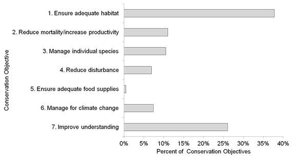
Long description for Figure 6
A horizontal bar graph indicating the percent of all conservation objectives (x axis) assigned to each conservation objective category (y axis; i.e. ensure adequate habitat, reduce disturbance, etc.) in BCR 3 Prairie and Northern Region.
| Conservation Objective | Pourcentage des objectifs de conservation |
|---|---|
| 1 Ensure adequate habitat | 37.8 |
| 2 Reduce mortality/increase productivity | 11.0 |
| 3 Manage individual species | 10.5 |
| 4 Reduce disturbance | 6.9 |
| 5 Ensure adequate food supplies | 0.5 |
| 6 Manage for climate change | 7.4 |
| 7 Improve understanding | 26.0 |
Element 6: Recommended actions
Recommended actions indicate on-the-ground activities that will help to achieve the conservation objectives (Figure 7). Actions are strategic rather than highly detailed and prescriptive. Whenever possible, recommended actions benefit multiple species and/or respond to more than one threat. Recommended actions defer to or support those provided in recovery documents for species at risk at the federal, provincial or territorial level, but will usually be more general than those developed for individual species.
The largest proportion of recommended actions for BCR 3 PNR relate to law and policy (sub-categories 5.1 and 5.4), including increasing the enforcement of existing regulations, developing new regulations or beneficial management practices, and strengthening legislation. Actions involving management or protection of sites or habitats were recommended in 21% of cases. Direct management of species was recommended in only 18% of cases, a lower proportion than for some other regions because it would be difficult to achieve on the scale required for such a large and remote area. For some issues, it was determined that additional research or monitoring information was needed in order to devise appropriate conservation actions. Additional detail on suggested conservation actions is provided in the full strategy.
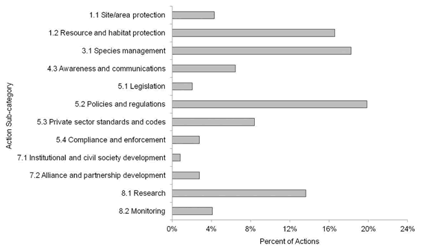
Long description for Figure 7
A horizontal bar graph indicating the percent of recommended action (x axis) assigned to each sub-category of recommended actions (y axis; i.e. Site/area protection, Species Management, etc.) in BCR 3 Prairie and Northern Region.
| Action Sub-category | Percent of Recommended Actions |
|---|---|
| 1.1 Site/area protection | 4.3 |
| 1.2 Resource and habitat protection | 16.6 |
| 3.1 Species management | 18.2 |
| 4.3 Awareness and communications | 6.5 |
| 5.1 Legislation | 2.1 |
| 5.2 Policies and regulations | 19.9 |
| 5.3 Private sector standards and codes | 8.4 |
| 5.4 Compliance and enforcement | 2.8 |
| 7.1 Institutional and civil society development | 0.8 |
| 7.2 Alliance and partnership development | 2.8 |
| 8.1 Research | 13.6 |
| 8.2 Monitoring | 4.1 |
References
CAVM Team. 2003. Circumpolar Arctic Vegetation Map (scale 1:7,500,000). Conservation of Arctic Flora and Fauna (CAFF) Map No. 1. U.S. Fish and Wildlife Service, Anchorage, Alaska, USA.
Donaldson, G. M., C. Hyslop, R. I. G. Morrison, H. L. Dickson, and I. Davidson (editors). 2000. Canadian Shorebird Conservation Plan(PDF; 1.92 MB). Canadian Wildlife Service, Environment and Climate Change Canada, Ottawa, Ontario. 27 pp.
Fisheries and Oceans Canada. 2009. Development of a Framework and Principles for the Biogeographic Classification of Canadian Marine Areas. DFO Can. Sci. Advis. Sec. Sci. Advis. Rep. 2009/056.
Food and Agriculture Organization (FAO). 2000. Land cover classification system. United Nations Food and Agriculture Organization, Rome.
Gantner, B. and A.J. Gaston. in prep. Birds. Chapter 4 in “The Arctic Biodiversity Assessment” (H. Meltote, ed.). Conservation of Arctic Flora and Fauna.
Kennedy, J.A., E.A. Krebs and A.F. Camfield. 2012. A Manual for Completing All-bird Conservation Plans in Canada, June 2012 version. Canadian Wildlife Service, Environment and Climate Change Canada. Ottawa, ON
Leafloor, J. O., T. J. Moser, and B. D. J. Batt (editors). 2012. Evaluation of special management measures for midcontinent lesser snow geese and Ross's geese. Arctic Goose Joint Venture Special Publication. U.S. Fish and Wildlife Service, Washington, D.C. and Canadian Wildlife Service, Ottawa, Ontario.
Milko, R., L. Dickson, R. Elliot, and G. Donaldson. 2003. Wings Over Water: Canada's Waterbird Conservation Plan. Canadian Wildlife Service, Environment and Climate Change Canada, Ottawa, Ontario. 28 pp.
North American Waterfowl Management Plan (NAWMP), Plan Committee. 2004. North American Waterfowl Management Plan 2004. Implementation Framework: Strengthening the Biological Foundation. Canadian Wildlife Service, U.S. Fish and Wildlife Service, Secretaria de Medio Ambiente y Recursos Naturales, 106 pp.
North American Waterfowl Management Plan (NAWMP). 2012. North American Waterfowl Management Plan 2012: people conserving waterfowl and wetlands. Canadian Wildlife Service, U.S. Fish and Wildlife Service, Secretaria de Medio Ambiente y Recursos Naturales. 70 pp.
Rich, T.D., C.J. Beardmore, H. Berlanga, P.J. Blancher, M.S.W. Bradstreet, G.S. Butcher, D.W. Demarest, E.H. Dunn, W.C. Hunter, E.E. Iñigo-Elias, J.A. Kennedy, A.M. Martell, A.O. Panjabi, D.N. Pashley, K.V. Rosenberg, C.M. Rustay, J.S. Wendt et T.C. Will. 2004. Partners in Flight North American Landbird Conservation Plan. Cornell Lab of Ornithology. Ithaca (NY).
Species at Risk Public Registry. Accessed 4 April 2012. Schedule 1: List of Wildlife Species at Risk.