
Bird Conservation Strategy for region 7 in Quebec
- Abridged Version -
May 2013

The abridged version of the strategy available here contains a summary of the results, but does not include an analysis of conservation needs by habitat, a discussion of widespread conservation issues, or the identification of research and monitoring needs.
Table of Contents
- Preface
- Acknowledgements
- Bird Conservation Strategy for Bird Conservation Region 7 in Quebec: Taiga Shield and Hudson Plains
- Executive summary
- Introduction: Bird Conservation Strategies
- Section 1: Summary of results - All Birds, All Habitats
- References
List of figures
- Figure 1. Landcover in BCR 7 Quebec Region: Taiga Shield and Hudson Plains.
- Figure 2. Map of protected and designated areas in BCR 7 Quebec Region: Taiga Shield and Hudson Plains.
- Figure 3. Percent of priority species that are associated with each habitat type in BCR 7 Quebec.
- Figure 4. Percent of priority species that are associated with each population objective category in BCR 7 Quebec.
- Figure 5. Percent of identified threats to priority species within BCR 7 Quebec by threat sub-category.
- Figure 6. Percent of all conservation objectives assigned to each conservation objective category in BCR 7 Quebec.
- Figure 7. Percent of recommended actions assigned to each sub-category in BCR 7 Quebec.
List of tables
- Table 1. Priority species in BCR 7 Quebec, population objective, and the reason for priority status.
- Table 2. Summary of priority species, by bird group, in BCR 7 Quebec.
- Table 3. Number of priority species in BCR 7 Quebec by reason for priority status.
- Table 4. Relative magnitude of identified threats to priority species within BCR 7 Quebec by threat category and broad habitat class.
Preface
Environment and Climate Change Canada (ECCC) led the development of all-bird conservation strategies in each of Canada’s Bird Conservation Regions (BCRs) by drafting new strategies and integrating new and existing strategies into an all-bird framework. These integrated all-bird conservation strategies will serve as a basis for implementing bird conservation across Canada, and will also guide Canadian support for conservation work in other countries important to Canada’s migrant birds. Input to the strategies from Environment and Climate Change Canada’s conservation partners is as essential as their collaboration in implementing their recommendations.
Environment and Climate Change Canada has developed national standards for strategies to ensure consistency of approach across BCRs. Bird Conservation Strategies will provide the context from which specific implementation plans can be developed for each BCR, building on the programs currently in place through Joint Ventures or other partnerships. Landowners including Aboriginal peoples will be consulted prior to implementation.
Conservation objectives and recommended actions from the conservation strategies will be used as the biological basis to develop guidelines and beneficial management practices that support compliance with regulations under the Migratory Birds Convention Act, 1994.
Acknowledgements
Stéphane Légaré, Benoît Audet, François Fournier and Véronique Connolly were the main authors of this document that follows templates developed by Alaine Camfield, Judith Kennedy and Elsie Krebs with the help of the BCR planners in each of the Canadian Wildlife Service regions throughout Canada. However, work of this scope cannot be accomplished without the contribution of other colleagues who provided or validated technical information, commented on earlier draft versions of the strategy and supported the planning process. We would like to thank the following people: Matthieu Allard, Yves Aubry, Luc Bélanger, Martine Benoît, Daniel Bordage, Pierre Brousseau, Vincent Carignan, Richard Cotter, Marie-France Dalcourt, Emmanuel Dalpé-Charron, Bruno Drolet, Gilles Falardeau, Patricia Houle, Benoît Jobin, Sandra Labrecque, Claudie Latendresse, Josée Lefebvre, Christine Lepage, Cédric Paître, Jean-François Rail and François Shaffer.
Bird Conservation Strategy for Bird Conservation Region 7 in Quebec: Taiga Shield and Hudson Plains

Long description for this map
Map of the Bird Conservation Regions (BCR) of Canada with BCR 7, Quebec Region: Taiga Shield and Hudson Plains highlighted. Canada (with Alaska, Greenland and the northern portion of the United States of America) is shown very washed out, as it is only present to provide context for the location of the highlighted BCR 7 QC. The washed out Canadian map is divided by BCR (12 Canadian BCRs in total), each shown differently, and their exact locations and sizes are indistinguishable, aside from BCR 7 QC.
The highlighted BCR 7 QC includes most of northern Quebec, extending from James Bay to Labrador. It excludes the extreme northwest of Quebec and the southern half of the province. There is also a very narrow strip of the BCR which juts out from the main portion and is adjacent to the southern border of Labrador. The following legend appears in the top right corner of the map: “Bird Conservation Regions of Canada. 7 QC - Taiga Shield and Hudson Plains” and includes the Environment and Climate Change Canada logo, and the Government of Canada logo.
Executive summary
The Taiga Shield and Hudson Plains, Bird Conservation Region 7 (BCR 7), cover an area of 561 721 km² in Quebec and span the province from Hudson Bay and James Bay in the west to the Labrador border in the east. BCR 7-QC is mostly covered by taiga in its southern portion, while the northern portion is dominated by the forest-tundra ecotone, which represents the transition from boreal to arctic habitats. This BCR includes an extensive area of wetlands on the lowlands south of James Bay and numerous small lakes throughout its territory. The abundance of water provides important habitat for breeding waterfowl, and the coasts of Hudson Bay and James Bay are a major migration route and represent critical staging habitat for shorebirds. BCR 7 is one of the least populated areas of Quebec. The main human activities include hydroelectric developments, hunting and trapping.
We evaluated 152 bird species that occur in the region, and 54 were determined to qualify as priority species. All bird groups were represented, with 54% of the priority list consisting of landbirds, 22% shorebirds, 15% waterfowl and 9% waterbirds. Of these, 11 are species at risk either at the provincial and/or the federal level. Consistent with the prevalence of wetlands across the landscape, a majority of species (64%) used wetland habitats extensively. Riparian habitat (39%) and waterbodies (33%) are the other habitats most used by the priority species.
Population objectives were set on the basis of observed trends, but insufficient monitoring information was a pervasive issue in BCR 7-QC. Consequently, 57% of priority species, with representatives from all bird groups, were assigned an objective to “assess” population status while “maintaining” current levels in the interim. For 13% of species, population levels were deemed to be at or near the objective. These results do not imply that bird populations in Quebec’s BCR 7 have not changed in abundance in recent decades, but rather that a lack of rigorous monitoring information for the region precludes an assessment of status and assignment of quantitative objectives.
An assessment of threats identified a number of conservation issues facing priority species in the various habitats of BCR 7-QC. Important conservation issues facing this region’s avifauna include habitat loss and degradation due to current and potential increases in energy production (hydro-electricity) and mining projects. Even though the total area affected by these projects remains relatively small in comparison with the extent of this BCR, they still represent the most serious threats to priority bird species, along with climate change, in this area. Furthermore, the demographic parameters of many of the priority species in this region are poorly known. For 52 priority species (96% of priority species, 40% of threats overall), a lack of knowledge of population status and limiting factors was also considered to be a significant impediment to determining their conservation priority.
Therefore, actions related to knowledge acquisition are most often suggested in this BCR. Much of this region is difficult to access, and survey coverage is sparse and sporadic. An improved understanding of species’ status and the factors limiting their populations is a prerequisite for effective management of priority birds in this region. Recommendations are provided to address the information gaps. The other most recommended actions to reach population objectives are related to developing and implementing beneficial management practices, and targeting actions on habitats that will favour priority species.
Migratory birds occurring in BCR 7-QC face additional issues and threats that do not fit into the standard presentation format used in the BCR strategies. These include widespread issues (threats from collisions with human-made structures, pollution and climate change), global monitoring and research needs, and threats that occur when birds are outside Canada. An overview of these issues, the species affected and the proposed conservation actions is given.
This conservation strategy for Quebec’s BCR 7 builds on existing bird conservation strategies and complements those created for the other BCRs across Canada. These strategies will serve as a framework for implementing bird conservation nationally, and also identify international conservation issues for Canada’s priority birds. This strategy is not intended to be highly prescriptive, but rather is intended to guide future implementation efforts undertaken by various partners and stakeholders.
Introduction: Bird Conservation Strategies
Context
This document is one of a suite of Bird Conservation Region Strategies (BCR strategies) that have been drafted by Environment and Climate Change Canada for all regions of Canada. These strategies respond to Environment and Climate Change Canada’s need for integrated and clearly articulated bird conservation priorities to support the implementation of Canada’s migratory birds program, both domestically and internationally. This suite of strategies builds on existing conservation plans for the four “bird groups” (waterfowl,Footnote 1 waterbirds,Footnote 2 shorebirds,Footnote 3 and landbirdsFootnote 4) in most regions of Canada, as well as on national and continental plans, and includes birds under provincial/territorial jurisdiction. These new strategies also establish standard conservation planning methods across Canada, and fill gaps, as previous regional plans do not cover all areas of Canada or all bird groups.
These strategies present a compendium of required actions based on the general philosophy of achieving scientifically based desired population levels as promoted by the four pillar initiatives of bird conservation. Desired population levels are not necessarily the same as minimum viable or sustainable populations, but represent the state of the habitat/landscape at a time prior to recent dramatic population declines in many species from threats known and unknown. The threats identified in these strategies were compiled using currently available scientific information and expert opinion. The corresponding conservation objectives and actions will contribute to stabilizing populations at desired levels.
The BCR strategies are not highly prescriptive. In most cases, practitioners will need to consult additional information sources at local scales to provide sufficient detail to implement the recommendations of the strategies. Tools such as beneficial management practices will also be helpful in guiding implementation. Partners interested in participating in the implementation of these strategies, such as those involved in the habitat Joint Ventures established under the North American Waterfowl Management Plan (NAWMP), are familiar with the type of detailed implementation planning required to coordinate and undertake on-the-ground activities.
Strategy Structure
Section 1 of this strategy, published here, presents general information about the BCR and the subregion, with an overview of the six elementsFootnote 5 that provide a summary of the state of bird conservation at the sub-regional level. Section 2, included in the full strategy, provides more detail on the threats, objectives and actions for priority species grouped by each of the broad habitat types in the subregion. Section 3, also part of the full strategy, presents additional widespread conservation issues that are not specific to a particular habitat or were not captured by the threat assessment for individual species, as well as research and monitoring needs, and threats to migratory birds while they are outside of Canada. The approach and methodology are summarized in the appendices of the full strategy, but details are available in a separate document (Kennedy et al. 2012). A national database houses all the underlying information summarized in this strategy and is available from Environment and Climate Change Canada.
Characteristics of Bird Conservation Region 7
The Taiga Shield and Hudson Plains, Bird Conservation Region (BCR 7), extend across much of the Canadian Shield, spanning eight provinces and territories. In Quebec, the BCR covers an area of 561 721 km² and spans the province from Hudson Bay and James Bay in the west to the Labrador border in the east (Fig. 1). It is the largest of Quebec’s BCRs, representing 37% of the province’s territory. This region represents the transition from boreal to arctic habitats, bordered by boreal forests to the south and treeless tundra to the north. The northern limit of this BCR coincides with the limit of tree growth. Henceforth, “BCR 7-QC” will be used as shorthand for the Quebec portion of BCR 7.
Figure 1. Landcover in BCR 7 Quebec Region: Taiga Shield and Hudson Plains.
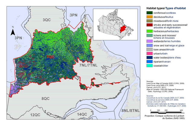
Text Description for Figure 1
Map of the landcover in BCR 7 Quebec Region: Taiga Shield and Hudson Plains. The map's extent includes the areas immediately surrounding the BCR in Quebec, Newfoundland and Labrador. The borders of BCR 3QC, 3PN, 7NL, 8QC, 8NL, 12QC and 14 QC are delineated. BCR 7 QC appears differently while the others appear as well. Inset in the upper right corner is a map of Canada with BCR 7 QC highlighted.
BCR 7 QC includes most of northern Quebec, extending from James Bay to Labrador. It excludes the extreme northwest of Quebec and the southern half of the province. There is also a very narrow strip of the BCR which juts out from the main portion and is adjacent to the southern border of Labrador. The various habitat types that exist in the BCR are shown on the map differently, which are explained in the following bilingual legend (appearing to the right of the map):
- Coniferous/conifères
- Deciduous/feuillus
- Mixedwood/forêt mixte
- Shrubs and early successional/arbustes et regeneration
- Herbaceous/herbacées
- Lichens and mosses/lichens et mousses
- Wetlands/terres humides
- Snow and ice/neige et glace
- Bare areas/denude
- Urban/urbain
- Water bodies /plans d'eau
- Riparian/riverain
- Coastal/côtier
The most common habitat types visible at this scale in BCR 7 QC are herbaceous (including tundra; more common in north), and waterbodies (more common in south). There is a concentration of wetlands in the extreme southwest of the BCR on the shores of James Bay. There is moderate amount of shrub and early successional habitat central-west portion of the BCR. Riparian areas appear in moderate concentration in the north of the BCR among the herbaceous habitat. The other habitat categories are not obviously abundant at this scale.
The remaining text in the legend is the following: Sources: Land Cover Map of Canada 2005 (CCRS, 2008), Land Cover circa 2000 (CTI, 2009), Canvec v 9.0 (CTI, 2011), Atlas of Canada 1,000,000 National Framework Data - Hydrology (CCRS, 2008). Sources: Couverture du sol du Canada 2005 (CCT, 2008), Couverture du sol circa 2000 (CIT, 2009), Canvec v 9.0 (CIT, 2011), Données-cadre nationales de l’Atlas du Canada à l’échelle du 1/1 000 000 - Hydrologie (CCT, 2008). There is also a visual representation of scale for the map in the legend which indicates 0, 100, 200 and 400 kms. The Projection is: “Conique conforme de Lambert du Québec (NAD 1983) ”.
Physical Environment
Topography
The relief of BCR 7-QC consists of plains and massive rolling hills, formed by the rock of the Canadian Shield. The altitude in the western part of the BCR varies from 100 m to 450 m, while the terrain in the east is more rugged, with some portions reaching an altitude of 915 m (Ecological Stratification Working Group 1996). The highest peaks in the BCR include Mount Geren (860 m), Hades hills (600 m), and other mountains that rise over 300 m like Mount Nuvulialuk, Mount Kaminiskutau, and Mount Apituwawakach (Direction générale de l’information géographique 2001).
Hydrography and Hydrology
BCR 7 is drained by major rivers such as the Caniapiscau, Rupert, Larch, Leaf, George, Eastmain, La Grande and Great Whale rivers. The presence of large rivers in the region has spurred the development of numerous hydroelectric energy projects including the construction of the largest hydroelectric complex in Canada, La Grande. The La Grande complex is fed by a series of rivers and reservoirs whose total surface area exceeds half that of Lake Ontario. These include the Robert-Bourassa (2835 km²), La Grande 3 (2420 km²), Caniapiscau (4275 km²) and Opinaca (1040 km²) reservoirs (Ministère du Développement durable, de l’Environnement et des Parcs 2002). Numerous small lakes are also present throughout the BCR.
Climate
The climate of BCR 7-QC is subarctic, characterized by relatively short, cool summers with prolonged periods of daylight and long, very cold winters. The average annual temperature is between −6 ° and −4.5 °C and mean annual precipitation ranges from 475 to 900 mm (Ecological Stratification Working Group 1996). The average temperature ranges from 6 to 8.5 °C in summer, and from −18 to −16.5 °C in winter. Snow covers the ground from six to eight months per year.
According to several models, the northern regions of Quebec will be particularly strongly affected by climate change in the coming decades. By 2050, BCR 7 may experience an increase in average temperatures of 2 to 4.5 °C and an increase in rainfall of up to 32% (adapted from Bourque and Simonet 2008). Climate change is expected to alter the dynamics of natural disturbances (fire and insects) and frequency of extreme weather events (e.g., ice storms and drought).
Land Cover and Land Use
More than a quarter of BCR 7 is coniferous forest, which covers most of the lower portion of the region (Fig. 1). Herbaceous vegetation is equally important, covering 27% of the BCR, mostly in the upper portion of the region. Waterbodies are abundant and cover 19% of this BCR. Other habitat types that individually cover less than 10% of the BCR include mixedwood, lichens and mosses, and shrubs and early successional vegetation. Wetlands, which represent almost 6% of the BCR, are mostly concentrated on the lowlands south of James Bay. The main human activities are hydroelectric developments, hunting, trapping and recreation (Ecological Stratification Working Group 1996). The entire BCR is part of the area covered by the Quebec government’s Plan Nord, for which the objective is to develop in a sustainable manner the economic potential of Northern Quebec. The economic sectors targeted by the Plan Nord in BCR 7 include mining, transportation and telecommunications (Ministère des Ressources naturelles et de la Faune 2011). In 2011, the Quebec government committed to devoting 50% of the territory covered by the Plan Nord to protecting the environment, safeguarding biodiversity, sustaining the natural heritage and developing various types of non-industrial activities by 2035.
Biological Environment
Vegetation
BCR 7-QC is represented by three vegetation types: the boreal forest, the taiga and the forest-tundra ecotone (Ministère des Ressources naturelles 2013). The boreal forest covers the south-western corner of the BCR and is characterized by spruce-moss forest, where black spruce dominates and balsam fir, white birch and trembling aspen are present. The understory is dominated by moss and ericaceous shrubs and has relatively few herbaceous plant species. The southern half of the BCR is largely taiga, characterized by spruce-lichen woodlands where black spruce occurs at lower density than in the spruce-moss forest. This is where balsam fir and jack pine reach the northern limit of their range. The northern half of the BCR is dominated by the forest-tundra ecotone, which represents the transition between the boreal and arctic zones. The landscape is a mosaic of shrub-dominated areas interspersed by trees or clumps of trees, mostly stunted black spruces. Since BCR 7-QC is located north of the commercial forest area, no significant forestry activity is reported in this sector. Therefore, these forest stands are the last large area of old-growth forests in Quebec. Fire is the main natural disturbance in these forests, with a cycle close to 100 years in the western portion of the BCR (Payette et al. 1989). Fires often cover large areas and influence the landscape by ensuring the maintenance of a diverse plant mosaic in species and ages that is characteristic of the taiga.
Wildlife
As a transition zone between the boreal and arctic ecosystems, BCR 7-QC offers a relatively wide variety of habitats for wildlife. Characteristic mammals include moose, black bear, wolf, beaver, marten, lynx, snowshoe hare and Labrador collared lemming. BCR 7-QC includes the winter range of the Leaf River and George River herds of Barren-ground caribou. Every fall, hundreds of thousands of caribou migrate south from the tundra to BCR 7 and travel back north in the spring to calve. The wolverine (Eastern population), which is a species listed as threatened in Quebec (Ministère du Développement durable, de l’Environnement, de la Faune et des Parcs 2013) and as endangered in Canada (Species at Risk Public Registry 2012), occurs in this BCR.
Given the harsh climate present in BCR 7, the herpetofauna is limited to eight species (seven amphibians and one reptile): the boreal chorus frog (a candidate for designation as threatened or endangered in Quebec), blue-spotted salamander, northern spring peeper, mink frog, northern leopard frog, wood frog, American toad and common garter snake. BCR 7’s waters are also home to several species of fish, which include the Atlantic salmon, lake trout, northern pike, lake whitefish, walleye, longnose sucker, white sucker and Arctic char.
BCR 7 is used by 152 species of birds for breeding, molting or during migration. The abundance of water in this BCR provides important habitat for breeding waterfowl with representative species including Canada Goose, Common Eider, Ring-necked Duck, Green-winged Teal, scaup, mergansers, and scoters (Lepage et al. in preparation). Breeding shorebirds include Greater Yellowlegs, Lesser Yellowlegs, Solitary Sandpiper, Marbled Godwit, Least Sandpiper and Short-billed Dowitcher (griseus). For a number of shorebird species breeding in the Canadian Arctic, the coastlines of Hudson Bay and James Bay are a major migration route. Some of the coastal marshes and beaches in Rupert Bay and Boatswain Bay are also important for many shorebirds (Aubry and Cotter 2007). The Arctic Tern, Herring Gull and Black Guillemot use islands and islets along the coast, and other representative waterbirds of this BCR include Red-throated Loon and Common Loon (Chapdelaine and Rail 2004). Characteristic landbirds include Willow Ptarmigan, Osprey, Northern Shrike, Common Raven, Gray-cheeked Thrush, American Tree Sparrow, White-crowned Sparrow and Common Redpoll (Drolet et al. 2010; Falardeau et al. 2010).
Human Environment
BCR 7 is one of the least populated areas of Quebec, with roughly 15 000 inhabitants, mostly Aboriginal peoples (Cree, Innu, Inuit and Naskapis), in 13 communities located primarily along James Bay, Hudson Bay and Ungava Bay. The main settlements are the Cree villages of Chisasibi (> 3800 inhabitants) and Waskaganish (> 2000 inhabitants; Aboriginal Affairs and Northern Development Canada 2010).
Protected and Designated Areas
At present, approximately 10% of the BCR 7-QC territory benefits from protected status (Fig. 2). There is only one federal protected area, the Boatswain Bay Migratory Bird Sanctuary, located along the east coast of James Bay. The vast majority of the territory is under provincial jurisdiction and includes 17 areas defined under 4 different types of provincial status. These include 9 proposed biodiversity reserves, four reserves for protected areas purposes, 3 national park reserves and 1 projected aquatic reserve. The largest protected entity in this BCR is the Quebec national park project of Tursujuq, a territory of nearly 1.5 million hectares located on the eastern side of Hudson Bay (Fig. 2). Seven Important Bird Areas are located in BCR 7-QC; they represent a territory of 9 420 km² (Fig. 2).
Figure 2. Map of protected and designated areas in BCR 7 Quebec Region: Taiga Shield and Hudson Plains.
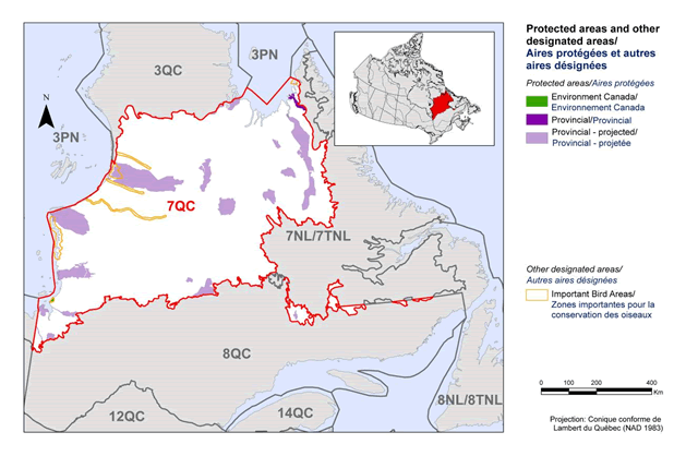
Long description for Figure 2
Map of protected and designated areas in BCR 7 Quebec Region: Taiga Shield and Hudson Plains. The map's extent includes The map's extent includes the areas immediately surrounding the BCR in Quebec, Newfoundland and Labrador. The borders of BCR 3QC, 3PN, 7NL, 8QC, 8NL, 12QC and 14 QC are delineated. BCR 7 QC appears differently while the others appear. Inset in the upper right corner is a map of Canada with BCR 7 QC highlighted.
BCR 7 QC includes most of northern Quebec, extending from James Bay to Labrador. It excludes the extreme northwest of Quebec and the southern half of the province. There is also a very narrow strip of the BCR which juts out from the main portion and is adjacent to the southern border of Labrador. The various types of protected areas that exist in the BCR are shown on the map differently, which are explained in the following bilingual legend (appearing to the right of the map):
Protected areas and other designated areas/Aires protégées et autres aireas designees:
Protected areas/Aires protégées
- Environment and Climate Change Canada/Environnement et Changement climatique Canada
- Provincial/Provincial
- Provincial - projected/Provincial - projetée
Other designated areas/Autres aires designees
- Important bird areas/Zones importantes pour la conservation des oiseaux
There is one small Environment and Climate Change Canada area on the coast of James Bay, and one small Provincial area on the north coast near Labrador. Otherwise, there are several large projected Provincial areas throughout the BCR.
There is also a visual representation of scale for the map in the legend which indicates 0, 100, 200 and 400 kms. The Projection is “Conique conforme de Lambert du Québec (NAD 1983) ”.
Section 1: Summary of Results - All Birds, All Habitat
Element 1: Priority Species Assessment
These Bird Conservation Strategies identify “priority species” from all regularly occurring bird species in each BCR subregion. Species that are vulnerable due to population size, distribution, population trend, abundance and threats are included because of their “conservation concern”. Some widely distributed and abundant “stewardship” species are also included. Stewardship species are included because they typify the national or regional avifauna and/or because they have a large proportion of their range and/or continental population in the subregion; many of these species have some conservation concern, while others may not require specific conservation effort at this time. Species of management concern are also included as priority species when they are at (or above) their desired population objectives but require ongoing management because of their socio-economic importance as game species or because of their impacts on other species or habitats.
The purpose of the prioritization exercise is to focus implementation efforts on the issues of greatest significance for Canadian avifauna. Table 1 provides a full list of all priority species and their reason for inclusion. Tables 2 and 3 summarize the number of priority species in BCR 7 Quebec by bird group and by the reason for priority status.
The standardized species assessment method initially identified 57 priority species or populations in this BCR among the 152 species, subspecies or populations (specific populations are referred to as “species” for simplicity in this document) that occur in this region. A revision of the preliminary list by regional experts led to the removal of 14 priority species or populations and the addition of 11 new ones. Slightly less than half of the final 54 priority species (26) are recognized as being of conservation concern (Table 1; shaded cells), including 11 species that have a species at risk status either at the provincial and/or the federal level. The 28 remaining species are included for stewardship purposes (Table 1).
The 54 priority species are distributed unevenly among the 4 bird groups. Landbirds are by far the largest group, accounting for 54% of the priority species of this BCR (there are nearly three times more landbird species than any other bird group in this BCR; Table 2). Shorebirds stand out as having 80% of their species on the priority list, indicating the precarious situation for this bird group in this BCR in particular and in Canada in general (Donaldson et al. 2000). See Table 3 for more detailed information on reasons for priority status for each bird group.
Table 1. Priority species in BCR 7 Quebec, population objective, and the reason for priority status. Accessible Version of Table 1.
| Bird group | Total species | Total priority species | Percent listed as priority | Percent of priority list |
|---|---|---|---|---|
| Landbirds | 90 | 29 | 32% | 54% |
| Shorebirds | 15 | 12 | 80% | 22% |
| Waterbirds | 16 | 5 | 31% | 9% |
| Waterfowl | 31 | 8 | 26% | 15% |
| Total | 152 | 54 | 36% | 100% |
| Reason for priority listinga | Landbirds | Shorebirds | Waterbirds | Waterfowl |
|---|---|---|---|---|
| COSEWICb | 5 | 1 | 1 | 1 |
| Federal SARA listedc | 5 | 1 | 1 | 1 |
| Provincially listedd | 8 | 1 | 1 | 1 |
| National/Continental Concerne | 13 | - | - | - |
| Regional Concerne | 0 | - | - | - |
| Continental Stewardshipe | 15 | - | - | - |
| Regional Stewardshipe | 9 | - | - | - |
| Conservation Categoryf | - | 6 | - | - |
| Priority Tierg | - | - | 5 | - |
| NAWMPh | - | - | - | 7 |
| Expert reviewi | 4 | 6 | 0 | 1 |
a A single species can be on the priority list for more than one reason. Note that not all reasons for inclusion apply to every bird group (indicated by “-”).
b Species assessed by the Committee on the Status of Endangered Wildlife in Canada as Endangered, Threatened, or Special Concern.
c Species listed on Schedule 1 of the Species at Risk Act as Endangered, Threatened, or Special Concern.
d Species listed on Quebec’s Loi sur les espèces menacées ou vulnérables as Threatened, Vulnerable or Susceptible to become Threatened or Vulnerable.
e See Table 1
f Conservation category refers to species identified in the Canadian Shorebird Conservation Plan (Donaldson et al. 2000) as having a conservation category of 5, 4a, 4b or 3a at the continental level.
g Priority tier refers to species identified in Canada’s Waterbird Conservation Plan (Milko et al. 2003) as being Tier 1 or Tier 2.
h Species ranked in the North American Waterfowl Management Plan (Plan Committee 2004) as having Moderately High, High or Highest breeding or non-breeding conservation and/or monitoring need in the BCR.
i Species that were included based on expert opinion.
Element 2: Habitats important to priority species
Identifying the broad habitat requirements for each priority species within the BCR allowed species to be grouped by shared habitat-based conservation issues and actions. If many priority species associated with the same habitat face similar conservation issues, then conservation action in that habitat may support populations of several priority species. BCR strategies use a modified version of the standard land cover classes developed by the United Nations (Food and Agriculture Organization 2000) to categorize habitats, and species were often assigned to more than one habitat class.
In BCR 7-QC, habitats occupied by priority species can be grouped into 7 major classes (Fig. 3). Wetlands cover only 5.7% of the subregion’s territory (Fig. 1), but are used by 63% of priority species, representing 34 bird species from the 4 bird groups. The second and third most used habitat classes are riparian (39% of priority species) and waterbodies (33% of priority species), and coniferous habitats are also important with 26% of priority species. Among the 21 species using riparian habitat, shorebirds and landbirds are respectively represented by 8 and 7 species, whereas shorebird and waterfowl are the main inhabitants of the waterbodies habitat type. At the other end, even though herbaceous habitat covers 27% of BCR 7-QC, no priority species primarily uses this habitat in this BCR.
For more detailed information on priority species, threats and conservation actions related to each habitat type, please see the full version of this strategy.
Figure 3. Percent of priority species that are associated with each habitat type in BCR 7 Quebec.
Note: The total exceeds 100% because each species may be assigned to more than one habitat.
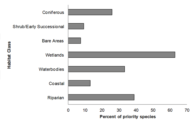
Text Description for Figure 3
A horizontal bar graph indicating the percent of priority species (x axis) that are associated with each habitat class (y axis, coniferous; shrub/early successional; bare areas; wetlands; waterbodies, and coastal in BCR 7 Quebec Region. Note: The total exceeds 100% because each species may be assigned to more than one habitat.
| Habitat class | Percent of Priority Species |
|---|---|
| Coniferous | 25.93 |
| Shrub/Early Successional | 9.26 |
| Bare Areas | 7.41 |
| Wetlands | 62.96 |
| Waterbodies | 33.33 |
| Coastal | 12.96 |
| Riparian | 38.89 |
Element 3: Population Objectives
Population objectives allow us to measure and evaluate conservation success. The objectives in this strategy are assigned to categories and are based on a quantitative or qualitative assessment of species’ population trends. If the population trend of a species is unknown, the objective is set as “assess and maintain”, and a monitoring objective is given. For any species listed under the Species at Risk Act (SARA) or under provincial/territorial endangered species legislation, Bird Conservation Strategies defer to population objectives in available Recovery Strategies and Management Plans. The ultimate measure of conservation success will be the extent to which population objectives have been reached over the next 40 years. Population objectives do not currently factor in feasibility of achievement but are held as a standard against which to measure progress.
Figure 4 shows that three categories of population objectives account for 90% of priority species in this BCR: “Assess/Maintain” (59%), “Recovery objective” (18%), and “Maintain current” (13%). The importance of the “Assess/Maintain” and “Maintain Current” categories reflects the high proportion of species that are on the priority list for stewardship reasons (28 out of 54 species). These two categories are not exclusively reserved for stewardship species, but stewardship species are typically given one or the other as a population objective; this reflects the fact that stewardship species often have stable population trends and are not unduly threatened. The importance of the “Assess/Maintain” category is also driven by the large number of priority species for which population trends are not well known or are unknown in this northern BCR. The issue of monitoring knowledge gaps will be addressed in Section 3 of the full version of this strategy.
The “Recovery objective” category stands out in this BCR because many (11) priority species in this region are species at risk, at the provincial and/or the federal level, and such species were automatically given this population objective category (except for the Nelson’s sparrow, candidate for designation as threatened or endangered in Quebec), though in some cases their recovery documents are not yet complete.
Figure 4. Percent of priority species that are associated with each population objective category in BCR 7 Quebec.
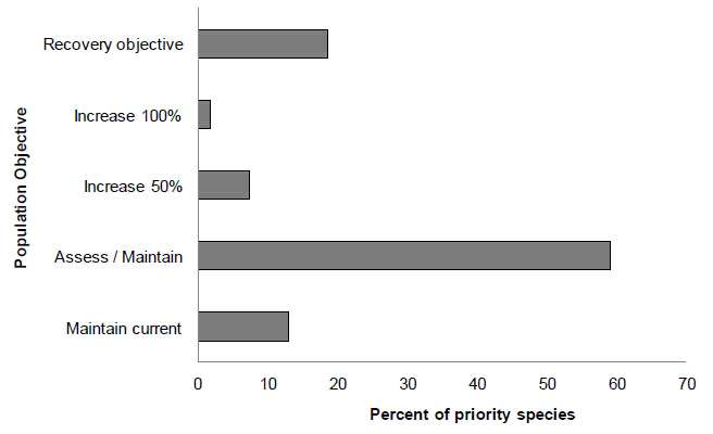
Text Description for Figure 4
A horizontal bar graph indicating the percent of priority species (x axis) that are associated with each population objective (y axis; recovery objective, increase 100%, increase 50%, assess/maintain, maintain current) in BCR 7 Quebec Region.
| Population Objective | Percent of Priority Species |
|---|---|
| Recovery objective | 18.52 |
| Increase 100% | 1.85 |
| Increase 50% | 7.41 |
| Assess / Maintain | 59.26 |
| Maintain current | 12.96 |
Element 4: Threat Assessment for Priority Species
The threats assessment process identifies threats believed to have a population-level effect on individual priority species. These threats are assigned a relative magnitude (Low, Medium, High, Very High), based on their scope (the proportion of the species’ range within the subregion that is impacted) and severity (the relative impact on the priority species’ population). This allows us to target conservation actions towards threats with the greatest effects on suites of species or in broad habitat classes. Some well known conservation issues (such as predation by domestic cats or climate change) may not be identified in the literature as significant threats to populations of an individual priority species and therefore may not be captured in the threat assessment. However, they merit attention in conservation strategies because of the large numbers of individual birds affected in many regions of Canada. We have incorporated them in a separate section on Widespread Issues (see complete version of the strategy), but, unlike other threats, they are not ranked.
Figure 5 shows that information is lacking for many priority species in BCR 7-QC (52 out of 54; also reflected in the importance of the “Assess/Maintain” population objective category in Figure 4), although the magnitude of this problem is considered low (Table 4). The “12.1 Information lacking” sub-category includes two factors: “Lack of knowledge on the biological or demographic parameters for proper management of populations” and “Species at risk without recovery strategy/management plan”. At the time of writing, of the 11 species at risk at the provincial and/or the federal level, only the Bald Eagle, Golden Eagle, Harlequin Duck (Eastern population) and Yellow Rail had recovery documents published.
The “3.3 Renewable energy” sub-category is an important threat in BCR 7-QC, accounting for 19% of all identified threats and having a medium or high magnitude. Eleven hydroelectric generating stations were active on the territory of BCR 7-QC in 2012 (Hydro-Quebec 2012). Even though the total area affected by these projects remains relatively small in comparison to the extent of BCR 7-QC, they still represent the most serious threat to priority bird species in this region. More explicitly, this threat sub-category refers to hydroelectric energy projects that modify hydrological systems, causing permanent or seasonal flooding of natural habitats and changes in salinity in coastal waters. Shorebirds are particularly affected by this threat.
The “3.2 Mining and quarrying”sub-category is the next most important threat, accounting for 10% of all identified threats and having a magnitude of medium. Mining activities currently cover a very small combined area on the BCR 7-QC territory. However, the Plan Nord could generate significant development of the mining sector, potentially leading to the loss, degradation, or contamination of freshwater, riparian and wetland habitats used by priority species such as shorebirds. In 2011, more than 50 exploration projects were active within the boundaries of BCR 7-QC (Gouvernement du Quebec 2012).
The “5.1 Hunting and collecting terrestrial animals” sub-category also accounts for 10% of all identified threats, but its magnitude is low. Two specific threats fall under this sub-category. One is the deliberate killing or accidental trapping of birds, which affects only two species, the Golden Eagle and Bald Eagle. The other one is the lack of knowledge on the extent of subsistence harvest and its impacts on bird populations, which is not a threat per se, but rather a conservation issue.
Other important threat sub-categories are “11.1 Habitat shifting and alteration” and “11.5 Other impacts”, both with high magnitudes. “11.1 Habitat shifting and alteration” refers to the loss and degradation of freshwater, coastal and wetland habitats caused by climate change that could potentially affect several species of shorebirds and some waterbirds. “11.5 Other impacts” is also related to climate change and refers to the possibility of a higher frequency of unfavourable climate events affecting migration, reproductive success, availability of prey (aerial insects) and/or nesting phenology. Aerial insectivores such as the Common Nighthawk and Olive-sided Flycatcher could potentially be affected by such climate events.
The “7.2 Dams and water management/use” threat sub-category, for which the magnitude is mostly medium, includes threats such as flooding of nests resulting from water level fluctuations in reservoirs and rivers, and the loss or degradation of freshwater, coastal and wetland habitats due to an increase in sedimentation rates caused by water-level management activities (a threat mostly affecting shorebirds).
Figure 5. Percent of identified threats to priority species within BCR 7 Quebec by threat sub-category.
Each bar represents the percent of the total number of threats identified in each threat sub-category in BCR 7-QC (for example, if 100 threats were identified in total for all priority species in BCR 7-QC and 10 of those threats were in the category 3.2 Mining and quarrying, the bar on the graph would represent this as 10%). The bars are divided to show the distribution of Low (L), Medium (M), High (H) and Very High (VH) rankings of individual threats within each threat sub-category. The overall magnitude of the sub-threat in the BCR is shown at the end of each bar.
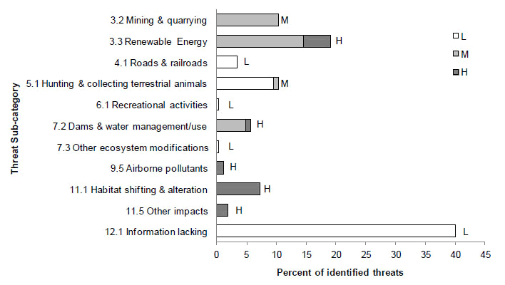
Text Description for Figure 5
A horizontal bar graph indicating the percent of identified threats to priority species (x axis) within BCR 7 Quebec Region by threat subcategory (y axis; i.e. mining and quarrying, airborne pollutants, etc.).
Each bar represents the percent of the total number of threats identified in each sub-threat category in BCR 7 (for example, if 100 threats were identified in total for all priority species in BCR 7, and 10 of those threats were in the category 1.1 Housing and urban areas, the bar on the graph would represent this as 10%). Shading in the bars (VH = very high, H = high, M = medium and L = low) represents the rolled up magnitude of all threats in each threat subcategory in the BCR.
| Threat Sub-category | Percent of Identified Threats Low |
Percent of Identified Threats Medium |
Percent of Identified Threats High |
|---|---|---|---|
| 3.2 Mining and quarrying | 0 | 10.31 | 0 |
| 3.3 Renewable energy | 0 | 14.5 | 4.58 |
| 4.1 Roads and railroads | 3.44 | 0 | 0 |
| 5.1 Hunting and collecting terrestrial animals | 9.54 | 0.76 | 0 |
| 6.1 Recreational activities | 0.38 | 0 | 0 |
| 7.2 Dams and water management/use | 0 | 4.96 | 0.76 |
| 7.3 Other ecosystem modifications | 0.38 | 0 | 0 |
| 9.5 Airborne pollutants | 0 | 0 | 1.15 |
| 11.1 Habitat shifting and alteration | 0 | 0 | 7.25 |
| 11.5 Other impacts | 0 | 0 | 1.91 |
| 12.1 Information lacking | 40.08 | 0 | 0 |
Table 4 shows that the broad threat category “3. Energy production and mining” has an overall magnitude of high and that its magnitude is highest in the waterbodies, wetlands, coastal and riparian habitat classes, where several species of shorebirds occur. Threat category “11. Climate change and severe weather” also has an overall magnitude of high and its magnitude is highest in wetland and coastal habitats.
Threat category “9. Pollution” has an overall magnitude of medium. This category includes the acidification of wetlands and waterbodies due to airborne pollutants, a threat to the American Bittern. The other pollution-related threat is the contamination of prey by mercury and lead fishing tackle, and is specific to the Bald Eagle in the waterbodies and coastal habitat classes. Threat category “7. Natural system modifications” is another with an overall magnitude of medium and includes threats from sub-category “7.2 Dams and water management/use” described above, as well as a threat specific to Brant, the decline in eelgrass distribution and abundance in Hudson Bay. Threat category “12. Other” refers to sub-category “12.1 Information lacking” shown in Figure 5 and explained earlier.
The wetlands and coastal habitat classes are those with the highest overall threat magnitude. Wetlands have the highest number of priority species (see Fig. 3), and coastal habitats are used by several species of shorebirds that have a precarious status.
More detail on threats associated with the different habitat classes are presented in the complete version of the strategy. Threats to priority species while they are outside Canada during the non-breeding season were also assessed and are likewise presented in the complete version of the strategy.
| Threat category | Habitat class Coniferous |
Habitat class Shrub/Early Successional |
Habitat class Bare Areas |
Habitat class Wetlands |
Habitat class Waterbodies - freshwater |
Habitat class Coastal |
Habitat class Riparian |
Habitat class Overall |
|---|---|---|---|---|---|---|---|---|
| Overall | L | L | L | H | M | H | M | |
| 3. Energy production and mining | - | L | L | H | H | H | H | H |
| 4. Transportation and service corridors | - | - | - | L | - | - | - | L |
| 5. Biological resource use | - | L | L | L | L | L | L | L |
| 6. Human intrusions and disturbance | - | - | L | - | - | - | - | L |
| 7. Natural system modifications | - | - | - | M | M | M | M | M |
| 9. Pollution | - | - | - | M | M | M | - | M |
| 11. Climate change and severe weather | - | - | - | H | M | H | M | H |
| 12. Other | L | L | L | L | L | L | L | L |
Element 5: Conservation Objectives
Conservation objectives were designed to address threats and information gaps that were identified for priority species. They describe the environmental conditions and research and monitoring that are thought to be necessary for progress towards population objectives and to understand underlying conservation issues for priority bird species. As conservation objectives are reached they will collectively contribute to achieving population objectives. Whenever possible, conservation objectives were developed to benefit multiple species, and/or respond to more than one threat.
Conservation objectives were grouped under seven categories (Fig. 6). Ninety percent of the conservation objectives were represented by two categories: “1. Ensure adequate habitat” and “7. Improve understanding”. The conservation objectives in category “1. Ensure adequate habitat” are the following and pertain to freshwater, riparian, coastal and wetland habitats: “1.1 Ensure that land and resource-use policies and practices maintain or improve bird habitat”; “1.2 Maintain the size, shape and configuration of habitat within the natural range of variation”; and “1.3 Ensure the continuation of natural processes that maintain bird habitat”. Category “7. Improve understanding” refers to conservation objectives designed to address the lack of knowledge of breeding success and survival rates of several priority species, as well as the lack of information on Aboriginal subsistence hunting of Brant and several species of shorebirds.
Figure 6. Percent of all conservation objectives assigned to each conservation objective category in BCR 7 Quebec.
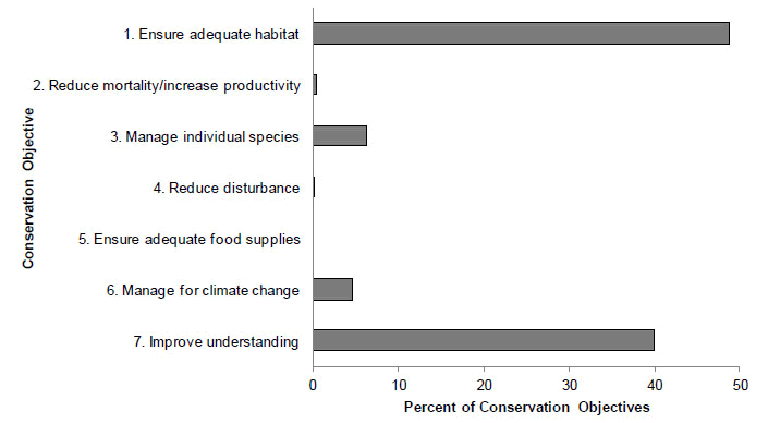
Text Description for Figure 6
A horizontal bar graph indicating the percent of all conservation objectives (x axis) assigned to each conservation objective category (y axis; i.e. ensure adequate habitat, reduce disturbance, etc.) in BCR 7 Quebec Region.
| Conservation Objective | Percent of Conservation Objectives |
|---|---|
| 1 Ensure adequate habitat | 48.78 |
| 2 Reduce mortality/increase productivity | 0.38 |
| 3 Manage individual species | 6.21 |
| 4 Reduce disturbance | 0.19 |
| 5 Ensure adequate food supplies | 0.00 |
| 6 Manage for climate change | 4.52 |
| 7 Improve understanding | 39.92 |
Element 6: Recommended Actions
Recommended actions indicate on-the-ground activities that will help to achieve the conservation objectives (Fig. 7). Actions are strategic rather than highly detailed and prescriptive. Whenever possible, recommended actions benefit multiple species, and/or respond to more than one threat. Recommended actions defer to or support those provided in recovery documents for species at risk at the federal, provincial or territorial level, but will usually be more general than those developed for individual species.
Figure 7 shows that close to half of the recommended actions in BCR 7-QC fall into sub-categories “8.2 Monitoring” and “8.1 Research”. Such actions are clearly needed to address the lack of knowledge for many priority species in this BCR. Another important sub-category is “5.3 Private sector standards and codes” (with 27% of all recommended actions), to which the following broad recommended actions were assigned: (a) encourage the adoption of more environmentally friendly operation standards; (b) establish policies/standards to regulate water levels/flow regimes; and (c) implement appropriate avoidance or mitigation measures identified in environmental assessment projects. These actions are needed to minimize the impacts of threats in category “3. Energy production and mining” (which has a high overall magnitude; see Table 4) on priority species and their habitats. Another sub-category related to this threat is “2.3 Habitat and natural process restoration”, which refers to the restoration of freshwater, wetland and riparian habitats after the completion of mining projects.
Category “1.1 Site area/protection” accounts for almost 10% of all recommended actions and includes actions aimed at identifying and protecting breeding and staging areas, particularly in wetland and riparian habitats. Sub-category “3.2 Species recovery” (6% of all recommended actions) includes recommended actions to address the lack of recovery documents for several of the priority species that are at risk either at the provincial and/or the federal level. Recommended actions under sub-category “6.2 Substitution” are aimed at reducing the potential impact of climate change on freshwater, coastal, riparian, and wetland habitats.
More details on recommended actions associated with the different habitat classes are presented in the full version of the strategy.
Figure 7. Percent of recommended actions assigned to each sub-category in BCR 7 Quebec.
“Research” and “monitoring” refers to specific species where additional information is required. For a discussion of broad-scale research and monitoring requirements, see the section on Research and Monitoring Needs in the complete version of the strategy.

Text Description for Figure 7
A horizontal bar graph indicating the percent of recommended action (x axis) assigned to each sub-category of recommended actions (y axis; i.e. Site/area protection, Species Management, etc.) in BCR 7 Quebec Region.
| Action Sub-category | Percent of Recommended Actions |
|---|---|
| 1.1 Site/area protection | 9.90 |
| 2.3 Habitat and natural process restoration | 4.95 |
| 3.2 Species recovery | 6.10 |
| 4.3 Awareness and communications | 0.19 |
| 5.2 Policies and regulations | 0.19 |
| 5.3 Private sector standards and codes | 26.67 |
| 6.2 Substitution | 4.57 |
| 7.2 Alliance and partnership development | 0.19 |
| 8.1 Research | 5.90 |
| 8.2 Monitoring | 41.33 |
References
Aboriginal Affairs and Northern Development Canada. 2010. Aboriginal peoples in Quebec. Retrieved July, 25, 2012.
Aubry, Y. and R. Cotter. 2007. Quebec Shorebird Conservation Plan. Environment and Climate Change Canada, Canadian Wildlife Service, Quebec Region, Sainte-Foy. xvi + 196 pp.
Bourque, A. and G. Simonet, 2008. “Quebec”, From Impacts to Adaptation: Canada in a Changing Climate 2007, edited by D.S. Lemmen, F.J. Warren, J. Lacroix and E. Bush. Government of Canada, Ottawa (Ont.), pp. 171-226.
Chapdelaine, G. and J.-F. Rail. 2004. Quebec’s Waterbird Conservation Plan. Migratory Bird Division, Canadian Wildlife Service, Quebec Region, Environment and Climate Change Canada, Sainte-Foy, Quebec. 99 pp.
Direction générale de l’information géographique. 2001. Carte toponymique du Québec. Photocartothèque québécoise, Ministère des Ressources naturelles et de la Faune, Québec, Québec.
Donaldson, G. M., C. Hyslop, R. I. G. Morrison, H. L. Dickson, and I. Davidson (editors). 2000. Canadian Shorebird Conservation Plan. Canadian Wildlife Service, Environment and Climate Change Canada, Ottawa, Ontario. 27 pp.
Drolet, B., V. Carignan, M.-A. Vaillancourt and G. Falardeau. 2010. Plan de conservation des oiseaux terrestres du Quebec : volume 1, oiseaux des milieux forestiers. Internal work document, Environment and Climate Change Canada, Canadian Wildlife Service, Quebec region.
Ecological Stratification Working Group. 1996. A National Ecological Framework for Canada; Agriculture and Agri-Food Canada, Research Branch, Centre for Land and Biological Resources Research, and Environment and Climate Change Canada, State of the Environment Directorate, Ecozone Analysis Branch, Ottawa/Hull.
Falardeau, G., V. Carignan, B. Drolet and M.-A. Vaillancourt. 2010. Plan de conservation des oiseaux terrestres du Quebec, volume 2 : les oiseaux des milieux agricoles, humides, urbains, arctiques, alpins et des falaises. Internal work document, Environment and Climate Change Canada, Canadian Wildlife Service, Quebec region.
Food and Agriculture Organization (FAO). 2000. Land cover classification system. United Nations Food and Agriculture Organization, Rome.
Gouvernement du Québec. 2012. Rapport sur les activité minières au Québec - 2011. Direction Générale de Géologie Québec, Gouvernement du Québec, 121 p. + annexes.
Hydro-Québec. 2012. Rapport annuel 2011. Hydro-Québec, Affaires corporatives et secrétariat général, 116 p.
Kennedy, J.A., E.A. Krebs and A.F. Camfield. 2012. A Manual for Completing All-bird Conservation Plans in Canada, April 2012 version. Canadian Wildlife Service, Environment and Climate Change Canada. Ottawa, ON
Lepage, C., D. Bordage, D. Dauphin, F. Bolduc and B. Audet. In preparation. Quebec Waterfowl Conservation Plan - 2010. Environment and Climate Change Canada, Canadian Wildlife Service, Quebec Region, Quebec.
Milko, R., L. Dickson, R. Elliot, and G. Donaldson. 2003. Wings Over Water: Canada’s Waterbird Conservation Plan. Canadian Wildlife Service, Environment and Climate Change Canada, Ottawa, Ontario. 28 pp.
Ministère du Développement durable, de l’Environnement et des Parcs. 2002. Portrait général de l’eau (in French only) [Online]. Retrieved September, 4, 2012.
Ministère des ressources naturelles et de la faune.2011. Plan Nord : building northern Quebec together, the project of a generation. Gouvernement du Québec, Québec. 156 pages.
Ministère des Ressources naturelles. 2013. Zones de végétation et domaines bioclimatiques du Québec (in French only). Retrieved April, 4, 2013.
Ministère du Développement durable, de l’Environnement,de la Faune et des Parcs. 2013. Liste des espèces désignées menacées ou vulnérables au Québec (in French only). (Accessed 4 May 2013).
North American Waterfowl Management Plan, Plan Committee. 2004. North American Waterfowl Management Plan 2004. Implementation Framework: Strengthening the Biological Foundation (PDF; 2.3 MB). Canadian Wildlife Service, U.S. Fish and Wildlife Service, Secretaria de Medio Ambiente y Recursos Naturales, 106 pp.
Panjabi, A. O., E. H. Dunn, P. J. Blancher, W. C. Hunter, B. Altman, J. Bart, C. J. Beardmore, H. Berlanga, G. S. Butcher, S. K. Davis, D. W. Demarest, R. Dettmers, W. Easton, H. Gomez de Silva Garza, E. E. Iñigo-Elias, D. N. Pashley, C. J. Ralph, T. D. Rich, K. V. Rosenberg, C. M. Rustay, J. M. Ruth, J. S. Wendt, and T. C. Will. 2005. The Partners in Flight Handbook on Species Assessment (PDF; 405 KB). Version 2005. Partners in Flight Technical Series No. 3 (PDF; 405 KB). Rocky Mountain Bird Observatory website.
Payette, S., C. Morneau, L. Sirois, and M. Desponts. 1989. Recent fire history of the northern Quebec biomes. Ecology 70: 656-673.
Rich, T.D., C.J. Beardmore, H. Berlanga, P.J. Blancher, M.S.W. Bradstreet, G.S. Butcher, D.W. Demarest, E.H. Dunn, W.C. Hunter, E.E. Iñigo-Elias, J.A. Kennedy, A.M. Martell, A.O. Panjabi, D.N. Pashley, K.V. Rosenberg, C.M. Rustay, J.S. Wendt, T.C. Will. 2004. Partners in Flight North American Landbird Conservation Plan. Cornell Lab of Ornithology. Ithaca, NY.
Species at Risk Public Registry. 2012. Appendix 1: List of Species at Risk (online). Retrieved September, 4, 2012.