
Boot Island National Wildlife Area management plan 2014
Table of contents
- About Environment Canada Protected Areas and Management Plans
- Boot Island National Wildlife Area
- 1. Description of the Protected Area
- 2. Ecological Resources
- 3. Management Challenges and Threats
- 4. Goals and Objectives
- 5. Management Approaches
- 6. Authorisations and Prohibitions
- 7. Health and Safety
- 8. Enforcement
- 9. Plan Implementation
- 10. Collaborators
- 11. Literature Cited
- Appendix I: Plant List for Boot Island National Wildlife Area, 2010
- Appendix II: Bird List for Boot Island National Wildlife Area
- Appendix III: Summary of Colonial Nesting Bird Records (Nest Counts) for Boot Island National Wildlife Area, 1964 to 2008
Document information
Acknowledgements:
The majority of the colonial bird data for Boot Island National Wildlife Area was collected over many years by a number of observers. We would like to thank the following people for their efforts: Adam Campbell, Peter Barkhouse, Bill Barrow, Barb Boiduk, Susan (Rodda) Bowes, Cyril Coldwell, Don Colpitts, Graham Daborn, Tony Erskine, Keith Galbraith, Jocelyne Gauvin, Gay Hanson, L. Hanson, Peter Hicklin, Etta Hudgins, Ron Hounsell, Randy Hicks, Jason Hudson, Larry MacDonnell, Andrew Macfarlane, Nancy (Lutz) MacKinnon, Randy Milton, Reg Newell, Cindy Pauley, Mark Pulsifer, Matthew Robinson, Sylvie Roussel, Peter C. Smith and Jim Wolford. Our apologies to those whose names we may have missed. This plan was written and prepared by Colin M. MacKinnon and Andrew C. Kennedy, Environment Canada, Canadian Wildlife Service, Atlantic Region.
Copies of this plan are available at the following addresses:
Environment Canada
Inquiry Centre
10 Wellington, 23rd Floor
Gatineau QC K1A 0H3
Toll Free: 1-800-668-6767 (in Canada only)
Email: enviroinfo@ec.gc.ca
Environment Canada - Canadian Wildlife Service
17 Waterfowl Lane, P.O. Box 6227
Sackville NB E4L 1G6
Telephone: 506-364-5044
Website for Environment Canada Protected Areas.
How to cite this document:
Environment Canada. 2014. Boot Island National Wildlife Area Management Plan. Environment Canada, Canadian Wildlife Service, Atlantic, 52 pp.
Photos: © Colin MacKinnon (Great Black-backed Gulls and Great Black-backed Gull nest); and Diane Amirault (landscape)
About Environment Canada Protected Areas and Management Plans
What are Environment Canada Protected Areas?
Environment Canada establishes marine and terrestrial National Wildlife Areas for the purposes of conservation, research and interpretation. National Wildlife Areas are established to protect migratory birds, species at risk, and other wildlife and their habitats. National Wildlife Areas are established under the authority of the Canada Wildlife Act and are, first and foremost, places for wildlife. Migratory Bird Sanctuaries are established under the authority of the Migratory Birds Convention Act, 1994 and provide a refuge for migratory birds in the marine and terrestrial environment.
What is the size of the Environment Canada Protected Areas Network?
The current Protected Areas Network consists of 54 National Wildlife Areas and 92 Migratory Bird Sanctuaries comprising more than 12 million hectares across Canada.
What is a Management Plan?
A Management plan provides the framework in which management decisions are made. They are intended to be used by Environment Canada staff to guide decision making, notably with respect to permitting. Management is undertaken in order to maintain the ecological integrity of the protected area and to maintain the attributes for which the protected area was established. Environment Canada prepares a management plan for each protected area in consultation with First Nations and other stakeholders.
A management plan specifies activities that are allowed and identifies other activities that may be undertaken under the authority of a permit. It may also describe the necessary improvements needed in the habitat, and specify where and when these improvements should be made. A management plan identifies Aboriginal rights and allowable practices specified under land claims agreements. Further, measures carried out for the conservation of wildlife must not be inconsistent with any law respecting wildlife in the province in which the protected area is situated.
What is Protected Area Management?
Management includes monitoring wildlife, maintaining and improving wildlife habitat, periodic inspections of facilities, enforcement of regulations, as well as the maintenance of signs and infrastructure. Research is also an important activity in protected areas; hence, Environment Canada staff carries out or coordinates research in some sites.
The Series
All of the National Wildlife Areas are to have a management plan. All of these management plans will be initially reviewed 5 years after the approval of the first plan, and every 10 years thereafter.
To learn more
To learn more about Environment Canada's protected areas, please visit our website at Protected Areas or contact the Canadian Wildlife Service.
Boot Island National Wildlife Area
Boot Island National Wildlife Area (NWA) supports significant populations of colonial nesting birds in a landscape shaped by a long history of human use, making it significant to both the biological diversity and uniqueness of this region. Boot Island NWA is located near the mouth of the Gaspereau River, near Wolfville in the province of Nova Scotia. The island is located in an area of extensive tidal mudflats that are important for foraging shorebirds.
Boot Island NWA was established in 1979 to protect an important staging and migration area for waterfowl and to a lesser extent a migration site for shorebirds. Among the 30 species of birds observed in the NWA, the island supports significant breeding colonies of Herring Gull, Greater Black-backed Gull, Great Blue Heron and Double-crested Cormorant. Due to significant concentrations of shorebirds in this area and in the larger area of the Southern Bight of the Minas Basin in which the island is situated, this basin was recognized as a Wetland of International Importance under the Ramsar Convention in 1987. In 1988, the area was also declared a Hemispheric Shorebird Reserve as part of the Western Hemisphere Shorebird Reserve Network.
Boot Island NWA is located at the eastern end of the Annapolis Valley, one of the prime agricultural areas in Nova Scotia. Boot Island has a 400-year history of human use and occupation by European immigrants. Boot Island was used by Acadian settlers in the 17th and 18th centuries, and it was during this time that extensive areas of salt marsh were converted to agricultural land.
Boot Island was connected to the mainland until the middle of the 19th century. The channel separating the island from the mainland is now nicknamed ''The Guzzle'', in reference to the loud noise of rushing water and the force associated with the changing tides. The name Boot Island is actually an anglicized version of the French name "le bout"-meaning "the end", in reference to this area having been a point of land. The last farmers and settlers abandoned Boot Island in the 1930s, and the area has been subject to little human disturbance since that time.
The tidal forces that developed and sustained both the island and the productive mud flats are today eroding the island. Boot Island has been eroding at a rate of 0.7 to 1.3 meters per year from 1992 to 2008. Erosion is especially prevalent along the north shore of the island adjacent to the island's forested area. Increasing sea levels, as a result of global warming and glacial isostatic adjustment subsidence, are expected to exacerbate erosion. Management action and physical structures to control erosion are logistically difficult and cost-prohibitive.
There are no roads, trails or buildings on Boot Island NWA, thus maintenance requirements are minimal. Inspection visits every two years are sufficient to survey and monitor the NWA. These visits include the repair and/or replacement of regulatory signage, monitoring of the colonial nesting bird colonies as well as measuring the rate of coastal erosion.
For greater certainty, nothing in this management plan shall be construed so as to abrogate or derogate from the protection provided for existing Aboriginal or treaty rights of the Aboriginal peoples of Canada by the recognition and affirmation of those rights in section 35 of the Constitution Act, 1982.
1. Description of the Protected Area
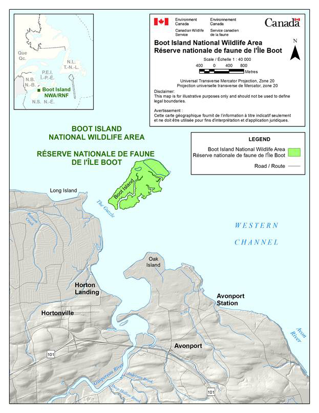
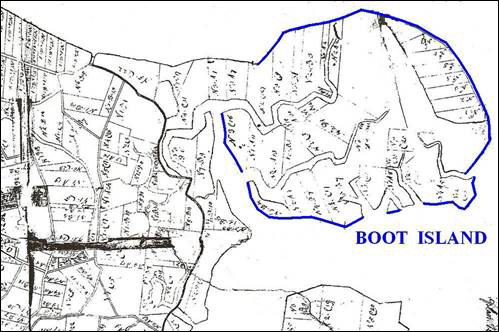
Boot Island National Wildlife Area (NWA) is situated within the Minas Basin near the mouth of the Gaspereau River, 8 km northeast of Wolfville, Kings County, Nova Scotia (45° 08 N, 64° 16 W; Figure 1). The 107-hectare NWA consists of approximately 85% (90.7 ha) salt marsh and 15% (15.9 ha) uplands comprised of forests and abandoned clearings and hayfields (Figure 2).
The salt marsh around the island is an important area for staging and migrating waterfowl and to a lesser extent migrating shorebirds. The uplands support breeding colonies of Herring Gull (Larus argentatus), Greater Black-backed Gull (Larus marinus), Great Blue Heron (Ardea herodias) and Double-crested Cormorant (Phalacrocorax auritus). Boot Island is an International Union for Conservation of Nature Category IV Protected Area. The site is managed by Environment Canada, Canadian Wildlife Service.
Boot Island NWA was purchased from private interests by the Government of Canada in 1977. Boot Island was declared an NWA on November 8, 1979, and is administered under the Wildlife Area Regulations of the Canada Wildlife Act.
| Protected Area Designation | National Wildlife Area |
|---|---|
| Province or Territory | Nova Scotia |
| Latitude and Longitude | 45° 08' N, 64°16' W |
| Size | 106.6 hectares (263 acres) |
| Protected Area Designation Criteria (Protected Areas Manual) | Protecting an area with concentrations of birds and colonial nesting birds, namely, Double-crested Cormorant, Great Blue Heron, Great Black-backed Gull and Herring Gull |
| Protected Area Classification System | Species or Critical Habitat Conservation |
| International Union for Conservation of Nature (IUCN) Classification | IV - Habitat/Species Management Area |
| Order in Council Number | PC 1979-3017 |
| Directory of Federal Real Property (DFRP) number | DFRP number 22844 |
| Gazetted | 8 November 1979 |
| Additional Designations | Wetland of International Importance (Ramsar site) and part of the Western Hemisphere Shorebird Reserve Network's Southern Bight Minas Basin Hemispheric Shorebird Reserve |
| Faunistic and Floristic Importance | Salt marsh supports spring and fall staging waterfowl. Uplands support a mixed seabird colony of Great Blue Heron, Double-crested Cormorant, Great Black-backed Gull and Herring Gull. In addition, the regionally rare salt marsh plant species, Big-leaf Marsh-elder and American Sea-blite, are found on the island. |
| Invasive Species | None identified as being a significant threat |
| Species at Risk | One Piping Plover record. Frequent use as a foraging area by Peregrine Falcon. |
| Management Agency | Environment Canada - Canadian Wildlife Service |
| Public Access and Use | Minimal - the site has limited access |
| Other Appropriate Information | Island is surrounded by a high-energy macro-tidal (10 m) environment. |
Long description for figure 1
Map of Boot Island National Wildlife Area in relation to Nova Scotia. Map is measured in meters.
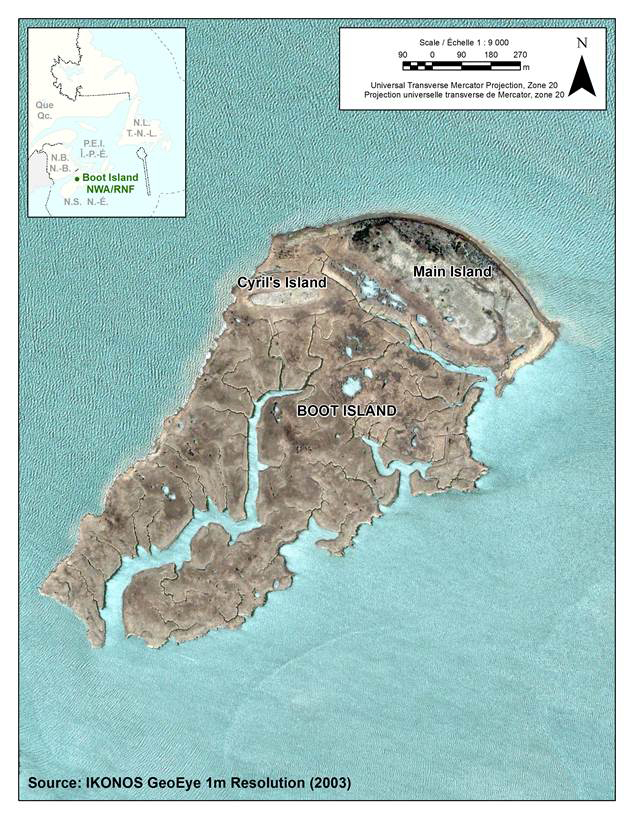
Source: IKONOS GeoEye 1m Resolution (2003)
Photo: © IKONOS GeoEye, 2003
Long description for figure 2
Aerial photograph of Boot Island National Wildlife Area in 2003. Map is measured in meters.
1.1 Regional Context
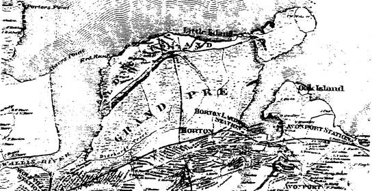
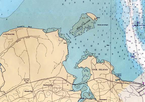
Boot Island is situated within the Southern Bight of the Minas Basin, Kings County, Nova Scotia. This basin is a southern arm of the Bay of Fundy bounded by Cape Blomidon to the north, Annapolis valley to the west, the Grand Pré dykelands to the south, and the mouths of the Gaspereau and Avon Rivers to the south and southeast respectively (Figure 3). The island lies just to the east of Evangeline Beach and is separated from the mainland by a narrow channel called ''The Guzzle''. Water levels in the Minas Basin can vary over 10 m between high and low water twice a day, making navigation not only difficult but also potentially dangerous.
The predominant feature of the immediate terrestrial landscape, of which Boot Island is the eastern-most extremity, is the approximately 100-km-long Annapolis Valley. The relatively flat basin of the valley, as well as adjacent hills of North and South Mountain, are used extensively for the growing of fruit trees as well as hay and grain crops and make this one of the prime agricultural areas in Nova Scotia. The nearby Grand Pré dykelands were once salt marsh but have been converted to agricultural use by a series of dykes that date back to Acadian settlement over 300 years ago (Bleakney, 2004). The marshes on Boot Island were also once drained and converted to agricultural land through the use of dykes and aboiteaux. Remnants of this dyke complex can be seen on Boot Island to this day.
The waters surrounding Boot Island are turbid, with a high silt load in suspension caused by the underlying sedimentary rock formations and high water volumes being moved by the tides (Desplanque and Mossman, 2004). This sediment has been deposited along the bay, providing an abundance of mud-flat habitat that is critical foraging habitat for migrating shorebirds (Hicklin, 1987). A variety of shorebird species utilize these mudflats; predominantly the Semipalmated Sandpiper (Calidris pusilla), which number in excess of 100 000 at major shorebird roosts at nearby Evangeline Beach and Blue Beach to the south (Mawhinney et al., 1993). Due to these significant shorebird concentrations, the Southern Bight of the Minas Basin was declared a Wetland of International Importance under the Ramsar Convention in 1987, and one year later on August 10, 1988, the same area was declared a Hemispheric Shorebird Reserve as part of the Western Hemisphere Shorebird Reserve Network.
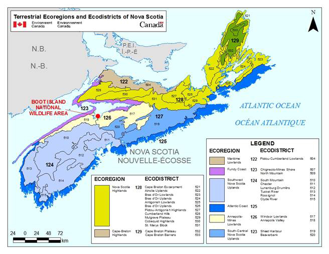
Long description for figure 3
Map of terrestrial ecoregions and ecodistricts of Nova Scotia. Ecoregions and ecodistricts are represented by different colors. Map is measured in kilometers.
1.2 Historical Background
Boot Island is believed to have received its name from early Acadian settlers who called the site "le bout" meaning the end. This presumably referred to the land mass that jutted out into the bay, the name ''le bout'' becoming anglicized to Boot (Mitcham, 1986). Boot Island was once connected to the mainland and was likely utilized by Acadian settlers in the late 17th and early 18th centuries. After the Acadian deportation in 1755, this area was settled by New England planters in the 1760s. The 1748 ''Morris'' map of the area clearly shows the island connected to present-day North Grand Pré by what appears to be salt marsh (Figure 4).
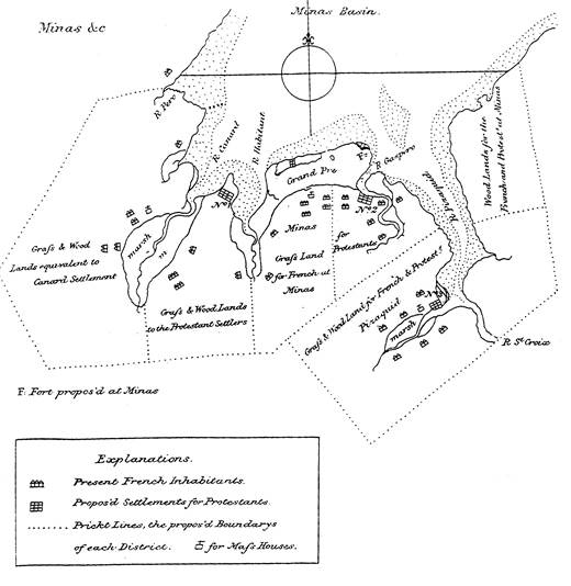
Source: Canada. Sessional Papers, 3 George V, 1912, No. 29b, "Report of the Archives Branch for the Year 1912", Appendix H.
Long description for figure 4
Hand drawn map representing Grand Pre and area, including Boot Island, by Charles Morris in 1748. Map shows where French inhabitants, settlements for protestants and the proposed boundaries of each district lie.
Although specific details are not known, earlier Aboriginal use would be expected, as one of the largest pre-historic settlement sites in Nova Scotia was situated at Melanson, just a few kilometres upriver from Boot Island (Nash and Stewart, 1990). By the mid-1800s, the island was mostly cut off from the mainland by erosion, as indicated on a map by A. F. Church (Figure 5 and Figure 6); however, there was at least one house on the island at this time. On October 30, 1913, a severe storm destroyed many of the dykes on the Boot Island marsh. The damage caused by this storm ultimately resulted in the families' moving off the island in 1914 (Bleakney, 2004). However, two families (William Biggs and Fred Allen), who were new to the area, bought the island in 1915. The families moved to Boot Island and lived together in the substantial two-story house located on the southeast side of Boot Island. They worked the land and rebuilt some of the dykes on the marsh, but hardships associated with living on an island forced them to move to the mainland (Mitcham, 1986).
Note: At this time the "island" was connected to the mainland.
Long description for figure 5
Survey plan of Boot Island and surroundings by John Harris in 1818. At this point in time the 'island' was connected to the mainland.
Source: A portion of a map of Kings County, Nova Scotia, by Ambrose F. Church, 1864.
Long description for figure 6
A map of Grand Pre area and Boot Island in 1864. Source: A portion of a map of Kings County, Nova Scotia, by Ambrose F. Church.
The last family to reside on the island was that of Leon Card in the 1930s. Later owners of the island resided on the mainland. Even though the families had moved off Boot Island, the fields still provided valuable crop land, and farmers frequented the island to cut hay. It is believed that most agricultural use of Boot Island ended in the late 1930s. The old farm house was still standing in 1946 (Figure 7b), and the fields have remained open. There has been some old field succession of mostly White Spruce (Picea glauca); however, the small forested area is quickly being diminished due to coastal erosion.
There are numerous accounts of the dangers encountered while travelling to and from the island by its residents and many visitors. Crossing at any time other than slack tide was, and continues to be, very dangerous, as the rising and falling tides rush in and out of the channel with great force. The channel, nicknamed ''The Guzzle'', reflects the loud noise of rushing water and the force associated with the changing tides.
Environment Canada's Canadian Wildlife Service purchased the island from private interests in 1977 to manage it for wildlife. It was named the Boot Island National Wildlife Area under the Wildlife Area Regulations of the Canada Wildlife Act on November 8, 1979.
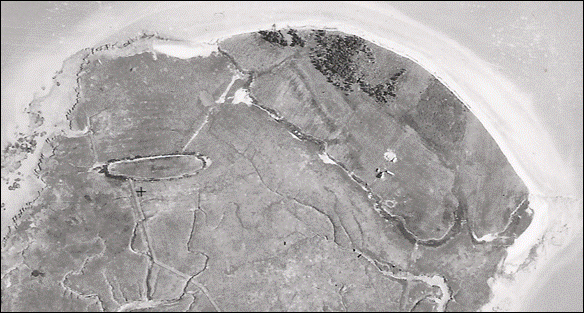
Long description for figure 7
Two aerial photographs of Boot Island, Nova Scotia in 1946. The island in the top photograph is 190m long.
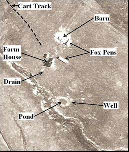
Photo: © Energy, Mines and Resources, Canada, 1946. A10178-5
Long description for figure 7
Two aerial photographs of Boot Island, Nova Scotia in 1946. The island in the top photograph is 190m long. The photograph is a zoomed in photograph of a spot on the island depicting a cart track, barn, farm house, fox pens, drain, pond and a well.
1.3 Land Ownership
The entire upland and salt marsh portion of Boot Island NWA is owned and administered by the Government of Canada. The property boundary follows the mean ''High Water'' mark (Normal Tide) around the island. The federal government does not hold the sub-surface mineral rights for Boot Island NWA.
Regarding the adjacent area, Boot Island is completely surrounded by sub-tidal and intertidal waters that are un-deeded and thus held as provincial Crown land. The closest adjacent mainland (Grand Pré) is predominantly privately owned farms with a nearby heritage site (Grand Pré National Historic Site) administered by Parks Canada. The province of Nova Scotia also administers the Minas Basin (186 ha) and Dewey Creek (55 ha) Wildlife Management Areas protected under Schedules "A" and "B" of the Lands and Forests Act (1987).
1.4 Facilities and Infrastructure
There are no roads, trails or buildings on Boot Island NWA, thus the maintenance requirements are minimal. Visits every two years include site inspections and repairs and/or replacement of regulatory signage (boundary, public notice and 2' x 4' NWA identification sign).
| Type of facility or infrastructure | Size or quantity | Responsibility holder |
|---|---|---|
| Property boundary | 4.75 km | Environment Canada - Canadian Wildlife Service |
| Boundary signs | 10 | Environment Canada - Canadian Wildlife Service |
| NWA entry signs | 1 | Environment Canada - Canadian Wildlife Service |
| Public Notice signs | 2 | Environment Canada - Canadian Wildlife Service |
| Erosion Monitoring Markers | 8 | Environment Canada - Canadian Wildlife Service |
1.5 Socio-Economic Assessment
The island is not presently used for any commercial activity, and its isolated location discourages visitation. The waters around the island are used for sea kayaking. The area is also important for a baitworm and flounder fishery, and the Boot Island salt marsh is frequented by waterfowl hunters in the fall.
Although no specific socio-economic studies have been conducted regarding this protected area, more general surveys have highlighted the value placed by the Canadian public on habitat set aside for wildlife (Environment Canada, 1991).
2. Ecological Resources
2.1 Terrestrial and Aquatic Habitats
The upland section, on the basin side of Boot Island, is about 6 m above sea level (a.s.l.) and is former agricultural land. It is vegetated with a stand of dense White Spruce following the general line of the cliff face, with a shrub-grass cover protected behind this forested fringe. The salt marsh consists of fertile alluvial deposits, left by the receding silt-laden tidal waters of the Minas Basin (Roland, 1982). Typical salt marsh plant communities (Hanson, 2004) occur throughout the marsh, with Salt-Meadow Cordgrasses (Spartina patens) and Saltmarsh Cordgrass (Spartina alterniflora) being the dominant species. Twice daily, high tides fill the channel area at the mouth of the Gaspereau River as well as the numerous tidal streams that intersperse the marsh (Smith, 1967) (Figure 8). The ''Boot'' became an island when the salt marsh that once connected it to the mainland was cut through by the tides. This erosion process is continuing and is especially prevalent along the north shore of the island adjacent to the forest component. See Appendix I: Plant list for Boot Island National Wildlife Area, 2010 for more information.
Note: Soundings are in feet.
Source: Canadian Hydrographic Service, 1982.
Photo: © Canadian Hydrographic Service, 1982.
Long description for figure 8
Nautical Chart of "Nova Scotia-Bay of Fundy, Avon River and Approaches No. 4140", based on 1969 surveys, showing Boot Island and the "Guzzle". Map is measured in feet and is gathered from the Canadian Hydrographic Service.
2.2 Wildlife
2.2.1 Birds
The waters and tidal flats of the Minas Basin support a high diversity of migratory birds, especially shorebirds (Environment Canada and Nova Scotia Department of Natural Resources, 1994). Inspection reports document 30 species of birds on or around Boot Island (1984-2008) (Appendix II: Bird list for Boot Island National Wildlife Area). Four species of colonial birds have been noted as breeding on Boot Island, including Double-crested Cormorant, Great Blue Heron, Herring Gull and Great Black-backed Gull. The following is a summary of colonial bird nesting activity within the NWA.
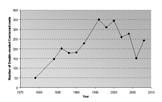
- Double-crested Cormorant - In 2008, 243 nests of Double-crested Cormorant were recorded on Boot Island. The colony has consistently been over 100 nests since 1984, with a peak of over 300 nests during 1996-2000. The nesting efforts of both this species and the Great Blue Heron have shortened the lifespan of many of the white spruce trees at the northern portion of the island due to feces (whitewash) on the vegetation (MacKinnon and Kennedy, 2006). At the rate the large trees are dying, the cormorants may at some point be forced to nest on the banks of the cliff, where they will be susceptible to mammalian predation (e.g. from coyotes and mink) (Figure 9 and Appendix III).
Long description for figure 9
| Year | Number of Double-crested Cormorant nests |
|---|---|
| 1979 | 50 |
| 1984 | 147 |
| 1986 | 201 |
| 1988 | 178 |
| 1990 | 181 |
| 1992 | 228 |
| 1996 | 351 |
| 1998 | 311 |
| 2000 | 345 |
| 2002 | 260 |
| 2004 | 277 |
| 2006 | 151 |
| 2008 | 243 |
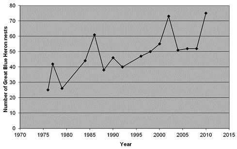
- Great Blue Heron - In 2008, 52 nests of Great Blue Heron were recorded on Boot Island. Surveys have recorded close to 50 nests annually since 1984 (low of 44 nests in 1984 and high of 73 nests in 2002). As with the cormorants above, the rapid decline in the remaining trees on the island and the demand for nest sites will place additional pressures on these birds. Herons will nest on the ground (examples at Haley Lake Migratory Bird Sanctuary and Margaree Island NWA), but this is not generally a preferred site for nesting. The establishment of herons on Boot Island around 1964 was believed to have been from the desertion of a small mainland colony (no other details are known) (Figure 10 and Appendix II).
Long description for figure 10
| Year | Number of Great Blue Heron nests |
|---|---|
| 1976 | 25 |
| 1977 | 42 |
| 1979 | 26 |
| 1984 | 44 |
| 1986 | 61 |
| 1988 | 38 |
| 1990 | 46 |
| 1992 | 40 |
| 1996 | 47 |
| 1998 | 50 |
| 2000 | 55 |
| 2002 | 73 |
| 2004 | 51 |
| 2006 | 52 |
| 2008 | 52 |
| 2010 | 75 |
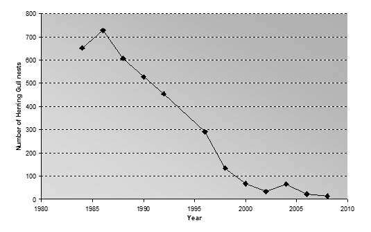
- Herring Gull - The number of Herring Gull nests has declined from 600 nests in the mid-1980s to only 13 nests in 2008. Many factors may have contributed to this decline, including reduced food availability due to the closure of local open dumps, predation by coyote that frequent the island and pressures from the more aggressive Great Black-backed Gull that share the nesting space (Figure 11 and Appendix II).
Long description for figure 11
| Year | Number of Herring Gull nests |
|---|---|
| 1984 | 651 |
| 1986 | 727 |
| 1988 | 606 |
| 1990 | 527 |
| 1992 | 454 |
| 1996 | 291 |
| 1998 | 134 |
| 2000 | 67 |
| 2002 | 33 |
| 2004 | 65 |
| 2006 | 22 |
| 2008 | 13 |
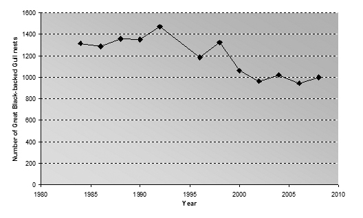
- Great Black-backed Gull - The number of Great Black-backed Gull nests rose from 1005 in 1976 to around 1300 in 1984. Numbers then remained the same or slightly increased, to a peak of 1467 nests in 1992. Since 1998, nesting Great Black-backed Gull numbers have been in decline (though not nearly as drastically as that of the Herring Gull), with 998 nests recorded in 2008. Great Black-backed Gulls appear to be dominating much of the nesting habitat on Boot Island. This species nests in two separate colonies on Boot Island. One colony is spread throughout the main island. The other group is situated on a raised upland within the salt marsh, known as Cyril's Island (alternately "Little Boot Island") (Figure 12 ) (also see Appendix III ).
Long description for figure 12
| Year | Number of Great Black-backed Gull nests |
|---|---|
| 1984 | 1314 |
| 1986 | 1284 |
| 1988 | 1358 |
| 1990 | 1351 |
| 1992 | 1467 |
| 1996 | 1184 |
| 1998 | 1322 |
| 2000 | 1060 |
| 2002 | 964 |
| 2004 | 1018 |
| 2006 | 943 |
| 2008 | 998 |
Significant numbers of shorebirds frequent the Minas Basin in July and August every year as part of their southward migration (Elliot, 1977; Hicklin, 1981; Hicklin, 1984; Mawhinney, 1991; Gilliland, 1992; Mawhinney et al. 1993). One of the larger shorebird roosts is at Evangeline Beach, 3 km west of Boot Island. Although Boot Island is not immediately surrounded by extensive mudflats, large numbers of shorebirds utilize the island's intertidal creeks and salt marsh.
Bald Eagles are frequently observed on Boot Island, and in 2008 a newly active nest was discovered in the fringe of trees adjacent to the Great Blue Heron and Double-crested Cormorant colony.
The island is visited every two years to conduct site inspections. These inspections include a survey of colonial nesting birds (number of nests and adult birds). Rates of coastal erosion and other wildlife observations are also noted.
Other bird observations are summarized in Appendix II.
2.2.2 Mammals
Mammalian species on Boot Island include an abundance of the Meadow Vole (Microtus pennsylvanica) and a likely less-abundant and probably diminishing population of the Red-backed vole (Clethrionomys gapperi) as well as frequent foraging visits by Eastern Coyote (Canis latrans) and Mink (Mustela vison) during the summer months (MacKinnon et al., 2007). No other mammal species have been recorded.
2.2.3 Reptiles and Amphibians
No reptile or amphibian species have been documented at this site.
2.2.4 Fish
Numerous tidal creeks cut their way through the salt marsh portion of Boot Island. As well, tidal pools exist in the salt marsh at low tide. Typical salt marsh-tidal pool species expected to occur are Banded Killifish (Fundulus majalis) and Fourspine Stickleback (Apeltes quadracus).
2.3 Species at Risk
No species at risk breed on Boot Island, although the Peregrine Falcon (Falco peregrinus) is a spring and fall transient and there was one Piping Plover (Charadrius melodus) observation in May of 2006.
There are two species of plants worth noting: Big-leaf Marsh-elder (Iva frutescens) and American Sea-blite (Suaeda calceoliformis) (Newell et al., 2006) (Table 3). These species are uncommon in Canada but are frequently found in salt marshes in New England (Bertness, 2007).
| Common and scientific names of the species | ACCDC Rank | Comments |
|---|---|---|
| Big-leaf Marsh-elder (Iva frutescens) | S2SE | A combination of two ranks indicates uncertainly about the exact rarity of the element. Here there seems to be uncertainty about whether this species is native or alien. If it is native, then it has a fairly significant rarity ranking. This species was found at two locations on Boot Island in the upper salt marsh. |
| American Sea-blite (Suaeda calceoliformis) | S2S3 | This is a tentative identification. It is recommended that confirmation be obtained from a botanist with expertise in the Chenopodiaceae family (Goosefoot family). Plants believed to belong to this species were found on the sand beach near the east end of Boot Island. |
Note: This table lists those species with an Atlantic Canada Conservation Data Centre (ACCDC) Sub-national (provincial) Rank of S3 or lower.
Source: Newell et al., 2006.
3. Management Challenges and Threats
A number of potential issues pertaining to the management of the Southern Bight Minas Basin Ramsar site have been outlined in the management plan for that site (Environment Canada and Nova Scotia Department of Natural Resources, 1994). As such, many of these factors have direct bearing on the successful management of Boot Island NWA. A summary of the more salient issues follow.
3.1 Baitworm Harvesting
The Bloodworm (Glycera dibranchiate) is a large polychaete worm that can reach a maximum length of 34 cm (Klawe and Dickie, 1957). This species is a favourite bait for saltwater sport fishing along the eastern coast of North America. The bloodworm is harvested by digging into the intertidal mudflats with a short-handled multi-pronged implement (a modified potato hack). The exposed bloodworm is then extracted. Using this method, many hectares of flats are turned over every year, and some bloodworm populations in the United States have been decimated this way. Currently harvest pressures appear to be at a manageable level, and the area around Boot Island is closed to baitworm harvesting (Environment Canada and Nova Scotia Department of Natural Resources, 1994; Shepherd, 1994; Westhead, 2005; DFO, 2009). In past years, Boot Island was used as a base camp for some baitworm harvesting.
3.2 Tourism
Sea kayaking is a rapidly growing recreation activity. More and more, unique and previously inaccessible areas are being promoted for day adventure opportunities; either as guided tours or in tourism promotion material. The waters around Boot Island are promoted as an area for sea kayaking, although the frequency or duration of the activity near Boot Island is not presently known. Evidence of temporary picnicking and camping at the island's boat landing area suggests some use over the summer months. Given that the entire upland portion of the island is occupied by colonial nesting birds, any prolonged visits to the island or boating close to the cliffs adjacent to the heron colony is likely to cause significant disturbance to the birds. Great Blue Herons, for example, will readily desert not just their nests, but sometimes the entire colony due to such disturbances.
In addition, the undeveloped nature of Boot Island as a protected area provides the greatest benefit as habitat for colonial nesting birds.
3.3 Tidal Power
There is currently renewed interest in developing tidal power production in the Bay of Fundy. Research in the 1970s suggested concerns caused by this technology, as earlier plans included full tidal barriers (Smith and Hicklin, 1984). Current proposals are considered to have less potential impact compared with earlier technologies, as they are in-flow devices; however, actual impacts on the mudflats or adjacent wetlands require additional study (Isaacman and Daborn, 2011).
3.4 Coastal Erosion and Habitat Loss
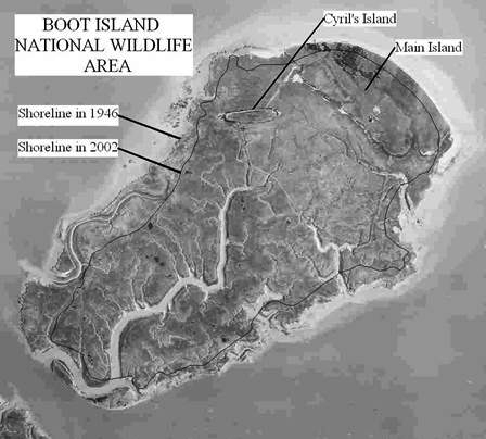
Boot Island was once connected to the mainland via a salt marsh to the east of North Grand Pré. A channel, now known as ''The Guzzle'', eventually eroded through this marsh, thus forming the island. Shoreline loss is still occurring at a considerable rate, as evident by comparing the 1946 and 2002 aerial photographs (Figure 13). The long, sinuous channel on the west side of the marsh in 1946 was completely gone by 2002. The area to the immediate north of Cyril's Island has dramatically changed shape. Furthermore, the seaward side of the upland portion of the Main Island has also receded, although the general ''crescent'' shape remains unchanged.
Aerial photograph 1946, Energy, Mines and Resources, Canada, A10178-5.
Photo: © Energy, Mines and Resources, Canada, 1946
Long description for figure 13
Black and White aerial photograph of Boot Island National Wildlife Area, Nova Scotia, depicting shoreline erosion from 1946 to 2002.
As the herons and cormorants nest in the wooded area immediately adjacent to the eroding cliffs, this loss of land has also meant loss of habitat. The upland fields have shown little or no forest succession, such that the rate of woodland loss far exceeds the replacement rate. The erosion rates across the northern portion of the island vary annually and spatially (Table 4 and Figure 14). The western end of the island has experienced an average shoreline retreat of 1.0-1.3 m/year while, for the eastern portion it has been less at 0.7-1.0 m/year (1992-2008). The range of erosion rates may reflect the direction of prevailing winds and storm events, which have the greatest impact on the island (Figure 15).
| No. | Survey marker: Name | 1992 | 1996 | 1998 | 2000 | 2002 | 2004 | 2006 | 2008 | Total change 1992 to 2008 |
Average change per year |
|---|---|---|---|---|---|---|---|---|---|---|---|
| 1 | Field | 26.9 | 22.4 | 21.1 | 19.4 | 18.4 | 17.9 | 16.5 | 15.3 | 11.6 | 0.7 |
| 2 | Field Edge | 31.1 | 27.1 | 25.5 | 24.7 | 22.3 | 22.1 | 20.1 | 20.1 | 11.0 | 0.7 |
| 3 | Outhouse | 30.1 | 24.5 | 23.3 | 19.2 | 19.1 | 16.7 | 14.9 | 12.8 | 17.3 | 1.1 |
| 4 | Gap | 38.1 | 33.4 | 31.6 | 29.6 | 29.1 | 25.3 | NR | 21.7 | 16.4 | 1.0 |
| 5 | Forest | 26.1 | 22.4 | 20.4 | 17.0 | 17.0 | 15.0 | 13.7 | 11.0 | 15.1 | 0.9 |
| 6 | Old Chair (Blow-down) | 26.7 | 20.3 | 17.5 | 15.0 | 12.8 | 9.8 | 8.3 | 6.7 | 20.0 | 1.3 |
| 7 | Open Glade | 23.5 | 16.4 | 13.4 | 11.9 | 9.5 | 7.6 | 6.6 | 4.2 | 19.3 | 1.2 |
| 8 | End of Island | 25.3 | 17.5 | 15.2 | 14.8 | 9.6 | 8.5 | 5.5 | 4.1 | 21.2 | 1.3 |
NR = not recorded
Note: See Figure 14 for transect locations.
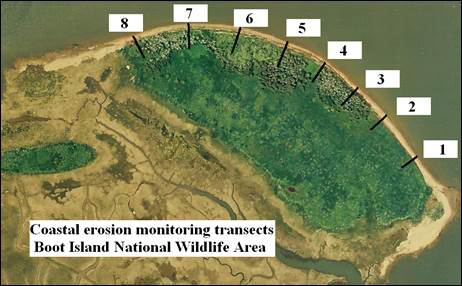
Photo: 1992 Photo No. 92305-86, 21H/1, 92-06-18.
Photo : © Environment Canada, 1992
Long description for figure 14
Aerial photograph of Boot Island National Wildlife Area depicting the location of control points 1-8, coastal erosion transects in 1992.
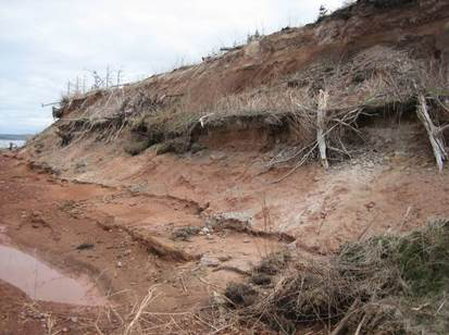
Photo: C. MacKinnon © Environment Canada, 2008
Long description for figure 15
Photograph of erosion 'terracing' on Boot Island National Wildlife Area in 2008, by C. MacKinnon.
The wooded interior of the island exhibits a high rate of change, mostly as a result of the guano and fish offal from the herons and cormorants, which kills the trees. The wooded area is also the most vulnerable to erosion. The forest stretches for about 450-500 m along the northernmost edge of the island adjacent to the cliffs. However, the width of the treed area only averages about 55 m (with wider portions up to 80 m) (Figure 16). Based on a ''worst case scenario'' (transect number 8, 1.4 m of erosion/year), the entire wooded area, which supports the herons and cormorants, could be gone in 40 to 60 years.
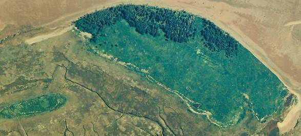
Photo: 1977 Photo No. A-77301-61, 21H/1 W, 3-7-77.
Photo : © Environment Canada, 1977
Long description for figure 16
Aerial photograph of Boot Island uplands and nearby "Cyril's Island", 1977.
3.5 Predicted Climate Change Impacts
The climate of Boot Island is classified in the Atlantic zone and is located in the Atlantic Maritime ecozone and the Annapolis-Minas Lowlands ecoregion. The climate within this ecoregion is strongly influenced by the Atlantic Ocean. High winds, high humidity and fog are characteristic of the summer and fall months. The region usually has cool, wet summers and mild, wet winters. Mean annual temperature is close to 6°C, with a mean summer temperature of 14.5°C and a mean winter temperature of -3°C. Mean annual precipitation amounts range from 1100 to 1400 mm. Tidal ranges of approximately 10 m occur in this portion of the Minas Basin. Recent analyses suggests that the regional climate will be shifting towards warmer winters and warmer summer nights, with mean annual temperature rising from 6ºC to 10ºC (Adam Fenech UPEI, unpubl. data).
Since 1992, the Canadian Wildlife Service has been monitoring the rate of erosion along the northwest and northeast face of the cliffs on Boot Island, with annual loss being about 1 m per year (Table 4). The rate of erosion appears to be more prevalent along the northwest side, where the island may be more exposed to storms and severe weather. However, a comparison of aerial photographs from 1946 to 2002 shows a significant reduction in the size of the island from all directions (Figure 13).
Most areas of the upper Bay of Fundy have experienced sea-level rise (combined with coastal subsidence) of approximately 13 m over the past 4000-5000 years (Shaw, 1998). A current estimate of crustal subsidence for the upper Bay of Fundy is 20 cm/100 yrs (Koohzare, 2005) with climate-induced changes of sea-level rise reported to be 90 cm/100 yrs based on current green-house gas emissions (Rahmstorf, 2007). As sea-level rise occurs, Boot Island is likely to experience increased erosion along the upland portion of the island.
4. Goals and Objectives
4.1 Vision
The long-term vision for Boot Island NWA is conservation through the maintenance of habitat for native wildlife and plants, with priority being given to the island's colonial nesting birds.
4.2 Goals and Objectives
Boot Island NWA was established to provide protection for the varied bird habitats within this coastal site. This goal is in accordance with A Wildlife Policy for Canada (Environment Canada, 1990). This policy states that the goal for a NWA is: "… to maintain and enhance the health and diversity of Canada's wildlife, for its own sake and for the benefit of present and future generations."
At the international level, Boot Island NWA is classified under the International Union for the Conservation of Nature criteria for protected areas as a Category IV Protected Area. The site is protected for the preservation of species and genetic diversity and scientific monitoring and research. It is not promoted as a tourism destination or for on-site public education. Public visitation, although not promoted, is not discouraged outside of the colonial bird nesting season, and some traditional activities are allowed.
Currently, the primary management goal for Boot Island NWA is to ensure that the colonial birds and other wildlife that nest or reside there are protected from outside disturbances, such that the potential for natural biological processes are maximized.
The specific goals and objectives are:
Goal 1. Habitat necessary to sustain populations of colonial nesting seabirds will be maintained.
- Objective: Forest habitats will be maintained so that populations of migratory birds nesting in this habitat are sustained and/or residences and habitats are created, restored, or maintained through active management. Remediate forest habitat loss from coastal erosion by planting White Spruce so that nesting area for colonial birds does not decrease in extent. An additional two hectares of new forested habitat will be planted by 2025.
4.3 Evaluation
Annual monitoring will be performed within the limits imposed by the availability of financial and human resources. The management plan will be reviewed 5 years after its initial approval, and reviewed and updated 10 years after that. The evaluation will take the form of an annual review of monitoring data obtained from the monitoring and research projects outlined below. This monitoring will be used to establish priorities for action and to allocate resources.
The management goal for Boot Island will be met and continuously evaluated through a long-term monitoring program, which incorporates field visits every two years. These data and information collected will be incorporated into broader species conservation initiatives and will be incorporated into revisions of this management plan where and when appropriate or required. A major addition of new information may be appended to the document (as required), to assist in site management and decision making.
| Management challenges and Threats | Goals and objectives | Management approaches |
|---|---|---|
Shoreline loss is occurring at a considerable rate, causing significant loss in marsh and forested habitats for nesting birds:
|
1.1. a) retain a forested component on Boot Island NWA for colonial nesting birds (specifically Double-crested Cormorant and Great Blue Heron). |
Monitoring:
|
5. Management Approaches
This section and Table 5 contain a description of all of the possible approaches that could be used in the management of Boot Island NWA. However, management actions will be determined during the annual work planning process and implemented as human and financial resources allow.
The major threat, overall, to the island is sea-level rise and a subsequent increase of erosion rates. Any protection against this coastal erosion is cost-prohibitive as well as debatable in terms of its effectiveness. Hence, management activities will focus on elements that can be addressed efficiently with limited resources.
5.1 Habitat Management
The recent decline in the forested area of the island, partly from erosion and partly due to trees being killed by nesting birds, is the most pressing threat. To partially remediate this loss, limited planting of salt-tolerant White Spruce (Picea glauca) seedlings has been implemented downslope from the eroding cliff face (~300 trees per site inspection). At present, planting of seedlings is having limited success, as the young trees are frequently being clipped and used as nest material by Great Black-backed Gull.
5.2 Alien and Invasive Plants
Non-native plants on the island have been present since colonization and are generally not invasive, which is why these naturalized species are considered separate from more recent arrivals of ''alien'' and ''invasive'' plant species. On Boot Island NWA, there are no significant threats from alien or invasive plant species as of 2010. Monitoring activities are sufficient to detect the presence of alien and invasive plant species.
Additional information on plant community was gathered by Newell et al. (2006), who compared the relative number of native and non-native plant species in different habitats of Boot Island NWA. The various salt marsh habitats retained 100% of their composition as native plant species, while the uplands, especially cliff habitats, showed a greater composition of non-native plant species (Table 6).
| Sand beach | Wooded upland | Open upland (field) | "Island" upland | Bank (cliff) face | Upper salt marsh | Middle salt marsh | Lower salt marsh (intertidal) | Tidal pools and barachois pond |
|---|---|---|---|---|---|---|---|---|
| 22.7% | 27.3% | 35.1% | 28.6% | 51.4% | 4.5% | 0% | 0% | 0% |
5.3 Wildlife Management
5.3.1 Species at Risk
There are now a number of active nest sites for Peregrine Falcon in the upper Bay of Fundy following a successful re-introduction program in the 1980s. Important shorebird concentration areas, such as Boot Island, are frequently visited by foraging falcons. No specific management action is required.
5.4 Monitoring
Boot Island NWA will be visited every 2 years for monitoring purposes due to its remoteness and limited opportunities for safe access. Corresponding to the outlined goals and objectives above, these site inspections will include monitoring coastal erosion rates (objective 1.1) as well as biological monitoring (wildlife populations with a focus on the colonial birds). During the inspections, observations of other changes in habitat, such as changes in plant composition of the nesting habitat due to native, non-native, alien and invasive plant species will be recorded. Large changes to the island (size and vegetation loss) can be monitored remotely using aerial photography obtained by Service Nova Scotia every 10 years (sub-goal 1.1).
Boot Island has little public use/visitation, and visitation during the seabird nesting season is not encouraged. Furthermore, there are no facilities of any kind on the island, so any formal management requirements would be directed to curtailing unwanted or undesirable public use. The ongoing site inspection schedule, which includes placement or replacement of National Wildlife Area regulatory signage, is presently adequate to monitor the island.
5.5 Research
Research activities will be considered for permitting when the results obtained through research have the potential for the following:
- Increasing knowledge with respect to forage resource available and influence on populations of colonial nesting seabirds;
- Increasing knowledge of impacts of sea-level rise on coastal erosion rates and potential adaptation strategies.
To request a permit to conduct research in Boot Island NWA and to obtain more information, please contact:
National Wildlife Area - Permit Request
Environment Canada, Canadian Wildlife Service
17 Waterfowl Lane, P.O. Box 6227
Sackville NB E4L 1G6
Permit requests should be directed to Permi.Atl@ec.gc.ca.
5.6 Public Information and Outreach
The unique character of Boot Island and its significance as a bird colony require public education and awareness ''at a distance''. The Canadian Wildlife Service Protected Areas website will provide written information on this NWA as well as visual representations of the ecological resources and physical character of the site.
6. Authorizations and Prohibitions
In the interest of wildlife and their environment, human activities are minimized and controlled in NWAs through the implementation of the Wildlife Area Regulations. These regulations set out activities that are prohibited (subsection 3(1)) in the wildlife area and provide mechanisms for the Minister of the Environment to authorize certain activities to take place in NWAs that are otherwise considered prohibited. The regulations also provide the authority for the Minister to prohibit entry into NWAs.
Activities within an NWA are authorized where notices have been posted at the entrance to or along the boundaries of the NWA or when notices have been published in local newspapers. All activities in an NWA are prohibited unless a notice has been posted or published authorizing the activity to take place. However, in addition to notices, certain activities may be authorized by obtaining a permit from the Minister of the Environment.
6.1 Prohibition of Entry
Under the Wildlife Area Regulations, the Minister may issue a notice that will be published in a local newspaper or posted at the entrance of any wildlife area or on the boundary of any part thereof prohibiting entry to any wildlife area or part thereof. Such a notice can be issued when the Minister is of the opinion that entry is a public health and safety concern or may disturb wildlife and their habitats.
For Boot Island NWA, entry is allowed without a permit.
Note: If there is a discrepancy between the information presented in this document and the notice, the notice prevails, as it is the legal instrument prohibiting entry.
6.2 Authorized Activities
For Boot Island NWA, the notice authorizing the following activities will be posted at the boat landing (eastern beach) in concert with an identification sign (2' x 4' NWA sign).
The following activities are authorized by notice for Boot Island NWA:
- hunting
- fishing
- trapping
- wildlife observation
- canoeing
- hiking
- skiing
- skating
- snowshoeing
- photography
- berry picking
Notes:
- Provincial and federal permits, limits, and ''seasons'' apply for hunting, fishing and trapping.
- If there is a discrepancy between the information presented in this document and the notice, the notice prevails, as it is the legal instrument authorizing the activity.
Applicable conditions for allowed activities correspond to the management vision for the Boot Island, i.e.: to maintain and enhance habitat for native wildlife and plants with priority being given to the island's colonial nesting birds.
6.3 Authorizations
Permits and notices authorizing an activity may be issued only if the Minister is of the opinion that the activity is scientific research relating to wildlife or habitat conservation, or the activity benefits the wildlife and their habitats or will contribute to wildlife conservation, or the activity is not inconsistent with the most recent management plan. These conditions must be met before the Minister will consider authorizing a prohibited activity.
The Minister may also add terms and conditions to permits and authorizations in order to minimize the impact of an activity on wildlife and their habitat.
All requests for permits or authorizations must be made (in writing) to the following address:
Environment Canada - Canadian Wildlife Service
National Wildlife Area - Permit Request
17 Waterfowl Lane, P.O. Box 6227
Sackville NB E4L 1G6
For further information, please consult the Policy when Considering Permitting or Authorizing Prohibited Activities in Protected Areas Designated Under the Canada Wildlife Act and Migratory Bird Convention Act, 1994 (December 2011). This Environment Canada policy document is available on the Protected Areas website.
6.4 Exceptions
The following activities will be exempt from the requirements for permitting and authorizations:
- Activities related to public safety, health or national security, that are authorized by or under another Act of Parliament or activities that are authorized under the Health of Animals Act and the Plant Protection Act to protect the health of animals and plants;
- Activities related to routine maintenance of NWAs, to the implementation of management plans, and enforcement activities conducted by an officer or employee of Environment Canada.
6.5 Other Federal and Provincial Authorizations
Depending on the type of activity, other federal or provincial permits may be required to undertake an activity in the Boot Island NWA. Contact your regional federal and provincial permitting office for more information.
National Wildlife Area - Permit Request
Environment Canada, Canadian Wildlife Service
17 Waterfowl Lane, P.O. Box 6227
Sackville, NB E4L 1G6
Province of Nova Scotia
Department of Natural Resources
Fish and Wildlife Division
136 Exhibition Street
Kentville NS B4N 4E5
7. Health and Safety
Any environmental emergency pertaining to Boot Island NWA should be reported to:
Maritimes Regional Office
Canadian Coast Guard
Fisheries and Oceans Canada
Telephone: 902-426-6030 or 1-800-565-1633
Non-emergency issues related to security or health and safety issues for Boot Island NWA should be reported to:
Environment Canada, Canadian Wildlife Service
17 Waterfowl Lane, P.O. Box 6227
Sackville NB E4L 1G6
Telephone: 506-364-5044
All reasonable efforts will be made to protect the health and safety of the public, including adequately informing visitors of any known or anticipated hazards or risks. Further, Environment Canada staff will take all reasonable and necessary precautions to protect their own health and assure safety as well as that of their co-workers. However, visitors (including researchers and contractors) must make all reasonable efforts to inform themselves of risks and hazards and must be prepared and self-sufficient. Natural areas contain some inherent dangers, and proper precautions must be taken by visitors, recognizing that Environment Canada staff neither regularly patrol nor offer services for visitor safety in NWAs.
Offshore islands, and activities along the seacoast in general, present issues of safety. In general, the public must seek and heed expertise to operate in these environments and obtain specialized training and certification, where required.
Boot Island NWA has no point of designated public access. Boot Island is remote, with no permanent staff. Any emergency should be reported immediately to the appropriate responding authorities. The report should include date, time and nature of the incident/accident, who is reporting, contact information of the reporting party (for follow-up information), and all relevant details. Multiple authorities should be advised, if the situation warrants, as soon as possible (Table 7).
| Emergency contacts for Boot Island NWA, Nova Scotia | No. |
|---|---|
| Any life-threatening emergency | 911 |
| Police-Fire-Ambulance | 911 |
| Royal Canadian Mounted Police (RCMP), Wolfville detachment | 1-902-542-3817 |
| Rescue Coordination Centre to report air and marine emergencies | 1-800-565-1582 |
| Environmental emergencies (oil, pesticide, chemical spills) | 1-800-565-1633 |
| Environment Canada - Wildlife Enforcement Division | 1-506-364-5036 |
| Environment Canada - Canadian Wildlife Service | 1-506-364-5044 |
| Nova Scotia Department of Natural Resources | 1-800-565-2224 |
8. Enforcement
To promote compliance with the Canada Wildlife Act and Wildlife Area Regulations, Environment Canada, Canadian Wildlife Service posts signs along the NWA boundaries and at main access points that identify what activities are authorized within each NWA and any conditions on those activities.
Environment Canada's Wildlife Enforcement Division (EC-WED) is responsible for enforcement of federal and provincial wildlife laws, and will perform on-site inspections and investigations, patrol the NWA to promote compliance, and prevent prohibited uses within the NWA.
EC-WED officers monitor compliance with the Canada Wildlife Act, Wildlife Area Regulations, the Migratory Birds Convention Act, 1994, the Species at Risk Act, andthe provincial Wildlife Act, 1989 on an ongoing basis and will initiate investigations when required. EC-WED officers will respond to violations and take appropriate enforcement actions. CWS Atlantic staff provides details from site inspections that may require investigation.
9. Plan Implementation
The management plan will be implemented over a 10-year period. Annual work plans will be developed in accordance with priorities and budgets, and the details of management plan implementation will be developed through Environment Canada's annual work planning process and will be implemented as human and financial resources allow. An adaptive management approach will be favoured for the implementation of the management plan. The implementation of the plan will be evaluated 5 years after its publication, on the basis of the actions identified in Table 5.
9.1 Management Authority and Mandate
Environment Canada, Canadian Wildlife Service - Atlantic is responsible for site management of Boot Island NWA.
9.2 Management Plan Review
Evaluation will take the form of a review of data obtained from the monitoring, surveys, and research projects and collaborative agreements outlined below. Monitoring and surveys at Boot Island NWA will be performed every two years within the limits imposed by financial and human resources. The data collected will be reviewed and be used to inform future management at the NWA. Furthermore, these data will be used to evaluate federal contributions towards accomplishing the mandates specific to Environment Canada for which the protected area was established.
This management plan will be reviewed 5 years after its formal approval by Environment Canada, Canadian Wildlife Service and every 10 years thereafter.
Additions of new information may be appended to the document as required to aid in site management and decision-making.
| Activity | 2014 | 2015 | 2016 | 2017 | 2018 | 2019 | 2020 | 2021 | 2022 | 2023 |
|---|---|---|---|---|---|---|---|---|---|---|
| Site inspection | blank | x | blank | x | blank | x | blank | x | blank | x |
| Colonial bird census | blank | x | blank | x | blank | x | blank | x | blank | x |
| Coastal erosion monitoring | blank | x | blank | x | blank | x | blank | x | blank | x |
| Tree planting | blank | x | blank | x | blank | x | blank | x | blank | x |
10. Collaborators
There are no formal arrangements with collaborators or partners pertaining to the management or administration of Boot Island NWA. There are other government agencies and organizations that have interests and mandates consistent with the management vision and objectives for Boot Island NWA.
The Grand Pré dykelands and surrounding area, centered on the Parks Canada site at Grand Pré, are being proposed as a World Heritage Cultural Landscape under UNESCO (UNESCO, 2009). As such, Boot Island may be included within this jurisdiction and indirectly subject to visitation and/or tourism pressures. Parks Canada has been advised of the protected status of Boot Island as well as the wildlife resources protected there.
Close working relationships are also maintained with the Nova Scotia Department of Natural Resources - Wildlife Division with frequent data and information sharing as it pertains to Boot Island.
The Blomidon Naturalist Club has frequently expressed the desire of its members to be kept advised of the status of bird numbers on Boot Island, and this information is readily provided by Environment Canada, Canadian Wildlife Service on the completion of each inspection visit.
11. Literature Cited
Atlantic Canada Conservation Data Centre. 2004. www.accdc.com/products/lists.
Banfield, A.W.F. 1974. The Mammals of Canada. National Museum of Natural Sciences, National Museums of Canada by the University of Toronto Press.
Barkhouse, H.P. 1976. A Proposal for the Acquisition of the Lands of Boot Island, King's County, Nova Scotia for the Establishment of the Boot Island National Wildlife Area. Canadian Wildlife Service Internal Report, Sackville, N.B.
Barkhouse, H.P., and A.D. Smith. 1981. A Preliminary Summary of Background Information on National Wildlife Areas in the Atlantic Region. Canadian Wildlife Service Internal Report, Sackville, N.B.
Bertness, M.D. 2007. Atlantic Shorelines: Natural History and Ecology. Princeton University Press. Princeton, New Jersey.
Bleakney, J. Sherman. 2004. Sods, Soil, and Spades: the Acadians at Grand Pré and their Dykeland Legacy. McGill-Queen's University Press, Montreal. 221 pp.
Brylinski, M. 1991. A short-term study to evaluate the potential impact of flounder draggers on the intertidal benthic habitat and community in Minas Basin, Bay of Fundy. N.S. Final Report, Acadia Centre for Estuarine Research, Publication No. 15, Acadia University, Wolfville, N.S.
Canada. Sessional Papers, 3 George V, 1912, No. 29b, "Report of the Archives Branch for the Year 1912", Appendix H.
Desplanque, C. and D.J. Mossman. 2004. Tides and their seminal impact on the geology, geography, history and socio-economics of the Bay of Fundy, eastern Canada. Atlantic Geology. 40(1): 1-130.
DFO. 2009. Nova Scotia Bloodworm (Glycera dibranchiata) Assessment: A Review of Methods and Harvest Advice. DFO Can. Sci. Advis. Sec. Sci. Advis. Rep. 2009/037.
Doull, Ian. 1995. Grand Pre Rural Historic District, Historic Sites and Monuments Board of Canada, Parks Canada (Agenda Paper), pp. 1203-1307.
Elliot, R.D. 1977. Roosting Patterns and Daily Activity of Migrating Shorebirds at Grand Pre, Nova Scotia. Unpublished M.Sc. Thesis, Acadia University, Wolfville, N.S., 157 pp.
Environment Canada. 1990. Wildlife Policy for Canada. Government of Canada. Ottawa.
Environment Canada. 1991. The Importance of Wildlife to Canadians.
Environment Canada. 2000. The Importance of Nature to Canadians: The Economic Significance of Nature-related Activities. Governement of Canada. Ottawa
Environment Canada and Nova Scotia Department of Natural Resources. 1994. Management plan for the Western Hemisperic Shorebird Reserve and Ramsar Wetland of International Importance at Southern Bight, Minas Basin, Bay of Fundy. Canadian Wildlife Service, Sackville, N.B. 20 pp.
Erskine, A.J. 1992. Atlas of breeding birds of the Maritime Provinces. The Nova Scotia Museum. Halifax, N.S. 270 pp.
Fisher, B.E. and Wenning, A. S. 2009. Mineral rights disposition map for the Province of Nova Scotia; Nova Scotia Department of Natural Resources, Mineral Resources Branch, Open File map ME 2009-6, scale 1:500 000. (Accessed 12 January 2010).
Gates, A.D. 1975. The tourism and outdoor recreation climate of the Maritime Provinces. Atmospheric Environment Service, Environment Canada. Toronto, Ontario. 133 pp.
Gilliland, K. 1992. Foraging ecology and body condition of migrant Semipalmated sandpiper Calidris pusilla on three mudflats in the bay of Fundy Hemispheric Shorebird Reserve, Nova Scotia, Unpublished MSc. Thesis, Acadia University, Wolfville, Nova Scotia, 74 pp.
Godfrey, W.E. 1986. The Birds of Canada. National Museum of Natural Sciences and National Museum of Canada. Ottawa, Ontario. 595 pp.
Gullett, D.W. and W.R. Skinner. 1992. A state of the environment report series #92-2. The state of Canada's climate: temperature change in Canada 1895 - 1991. Authority of the Minister of the Environment, Supply and Services. Ottawa, Ontario. 36 pp.
Hanson, A. 2004. Breeding bird use of salt marsh habitat in the Maritime Provinces. CWS Technical Report No. 414. Canadian Wildlife Service - Environment Canada. Sackville, New Brunswick, Canada.
Hicklin, P.W. 1981. Use of Invertebrate Fauna and Associated Substrates by Migrant Shorebirds in the Southern Bight, Minas Basin, Unpublished MSc. Thesis, Acadia University, Wolfville, N.S. 212 pp.
Hicklin, P.W. 1984. Selection of foraging sites and invertebrate prey by migrant Semipalmated Sandpipers Calidris pusilla (Pallas), in Minas Basin, Bay of Fundy. Canadian Journal of Zoology. 62: 2201-2210.
Hicklin, P.W. 1987. The migration of shorebirds in the Bay of Fundy. 1987. Wilson Bulletin 99(4). 540-570.
Isaacman, L. and G. Daborn. 2011. Pathways of Effects for Offshore Renewable Energy in Canada. Fundy Energy Research Network Document 2011-01. Acadia Centre for Estuarine Research, Wolfville, N.S. 74 pp.
Klawe, W.L. and L.M. Dickie. 1957. Biology of the bloodworm Glycer dibranchiata Ehlers and its relation to the bloodworm fishery of the Maritime Provinces. J. Fish. Res. Bd. Canada, Bulletin No. 115, 37 pp.
Koohzare, A., P. Vanicek and M. Santos. 2005. Compilation of a map of vertical crustal movements in Eastern Canada using spline polynomials. Extended abstract. Elements 32(2): 30-33.
MacKinnon, C.M. and A.C. Kennedy. 2006. Observations of Great Blue Heron Ardea herodias and Black-crowned Night Heron Nycticorax nycticorax and their Detrimental Effect on Nesting Habitat, Inkerman Migratory Bird Sanctuary, New Brunswick, 1971-2006. Technical Report Series No. 451. Canadian Wildlife Service, Atlantic Region. 32 pp.
MacKinnon, C.M., A.C. Kennedy and D.W. Colpitts. 2007. Eastern Coyote Canas latrans predation on Great Black-backed Gull Larus marinus eggs on Boot Island National Wildlife Area, Nova Scotia. Canadian Field-Naturalist 121(4):426-428.
Marie-Victorin, F. 1964. Flore Laurentienne, Le Presses de Université de Montréal, 925 pp.
Mawhinney, K. 1991. Use of foraging and roost sites in the Minas Basin Hemispheric Shorebird Reserve by migrating Semipalmated Sandpipers. Progress Report, Canadian Wildlife Service, Sackville, N.B. 13 pp.
Mawhinney, K.M., P.W. Hicklin and J.S. Boates. 1993. Re-evaluation of the numbers of migrant Semipalmated Sandpipers, Calidris pusilla in the Bay of Fundy during fall migration. Can. Field Nat. 107: 19-23.
Milton, G.R. 1983. The Winter Ecology of the Common Crow (Corvus brachyrhynchos, Brehm) in Eastern Kings County, Nova Scotia. MSc. Thesis, Acadia University, Wolfville, N.S.
Mitcham, Allison. 1986. Paradise or Purgatory: Island Life in Nova Scotia and New Brunswick. Lancelot Press, Hantsport, N.S., 225 pp.
Nash R.J. and F.L. Stewart. 1990. Large Micmac village in Kings County, Nova Scotia, Nova Scotia Museum, Curatorial Report No. 67, 260 pp.
NatureServe. 2004. NatureServe Explorer: An online encyclopedia of life [Web Application]. Version 1.8. NatureServe, Arlington, Virginia. (Accessed 15 February 2010).
Newell, R.E., C.M. MacKinnon and A.C. Kennedy. 2006. Botanical Survey of Boot Island National Wildlife Area, Nova Scotia, 2004. Technical Report Series No. 450, Canadian Wildlife Service, Atlantic Region, 32 pp.
Nova Scotia Atlas (Sixth Edition), 2006. Service Nova Scotia, 160 Willow Street, Amherst, N.S. B4H 3W5 and Formac Publishing Company Limited, 5502 Atlantic Street, Halifax, N.S. B3H 1G4.
Nova Scotia Museum of Natural History (1998). A brief history of ornithology in Nova Scotia. Retrieved January 8, 2010, from Nova Scotia Museum of Natual History website: http://museum.gov.ns.ca/mnh/nature/nsbirds/intro3.htm (Accessed 15 February 2010).
Quinney, T.E. 1979. Reproductive success, growth of nestlings and foraging behaviour of the Great Blue Heron (Ardea herodias L.). Acadia University, Wolfville, N.S.
Quinney, T.E. and P.C. Smith. 1980. Comparative foraging behaviour and efficiency of adult and juvenile great blue heron. Canadian Journal of Zoology, Volume 58(6): 1168-1173.
Rahmstorf, S. 2007. A semi-empirical approach to projecting future sea level rise. Science 315: 368.
Roland A.E. 1998. Roland's Flora of Nova Scotia. 3rd edition. Nimbus Publishing and the Nova Scotia Museum, Halifax, Nova Scotia. 2 Vols. 1297 pp.
Roland, Albert E. 1982. Geological Background and Physiography of Nova Scotia. The Nova Scotia Institute of Science, Halifax, N.S.
Rubec, C.D.A. 1996. Management of Canadian Ramsar Sites, Water and Habitat Conservation Branch, Environment Canada, Canadian Wildlife Service, Ottawa, 92 pp.
Shaw, J., Taylor, R.B., Forbes, D.L., Ruz, M.H. and Solomon, S. 1998. Sensitivity of the coasts of Canada to sea-level rise. Geological Survey of Canada, Bulletin 505: 1-79.
Shepherd, P.C.F. 1994. Effects of baitworm harvesting on the prey and feeding behaviour of shorebirds in the Minas Basin Hemispheric Shorebird Reserve. MSc. thesis, Acadia University, Wolfville, Nova Scotia, 95 pp.
Smith, A.D. 1967. Preliminary Report on Proposed Acquisition Areas in Nova Scotia. Canadian Wildlife Service Internal Report, Sackville, N.B.
Smith, P.C. and P.W. Hicklin. 1984. Potential impacts of tidal power developments on bird populations in the Bay of Fundy. In Gordon, D.C. and M.J. Dadswell (eds.), Update on the Marine Environmental Consequences of Tidal Power Development in the Upper Reaches of the Bay of Fundy, Can. Tech. Rep. Fish. Aquat. Sci. No. 1256, pp. 511-523.
UNESCO, 2009. World Heritage Nomination Proposal, Grand Pré Cultural Landscape (PDF format, 970 KB), 4 June 2009, 5 pp. (Accessed 8 February 2010).
Webb, K.T. and Marshall, I. B. 1999. Ecoregions and ecodistricts of Nova Scotia. Crops and Livestock Research Centre, Research Branch, Agriculture and Agri-Food Canada, Truro, Nova Scotia; Indicators and Assessment Office, Environmental Quality Branch, Environment Canada, Hull, Quebec. 39 pp. and 1 map.
Westhead, M.C. 2005. Investigations of the reference condition approach and intertidal ecology of Minas Basin, Bay of Fundy, with reference to the impacts of intertidal housing. M.Sc. Thesis, Acadia University, Wolfville, Nova Scotia, 148 pp.
Boot Island Inspection Reports (Canadian Wildlife Service Atlantic)
Barkhouse, H.P. 1984. Boot Island National Wildlife Area - May 10, 1984 Bird Colony Census. Canadian Wildlife Service Internal Report. Sackville, N.B. 5 pp.
Barkhouse, H.P. 1986. Boot Island National Wildlife Area - Bird Colony Census, May 16, 1986. Canadian Wildlife Service Internal Report. Sackville, N.B. 5 pp.
Barkhouse, H.P. 1988. Boot Island National Wildlife Area - Bird Colony Census, May 24, 1988. Canadian Wildlife Service Internal Report. Sackville, N.B. 5 pp.
MacKinnon, C.M. 1990. Boot Island National Wildlife Area - Bird Colony Census, 12 May 1990. Canadian Wildlife Service Internal Report. Sackville, N.B. 10 pp.
MacKinnon, C.M. 1992. Boot Island National Wildlife Area - Bird Colony Census, 20 May 1992. Canadian Wildlife Service Internal Report. Sackville, N.B. 13 pp.
Macfarlane, A. 1996. Bird Colony Census - Boot Island National Wildlife Area, May 13, 1996. Canadian Wildlife Service Internal Report, Sackville, N.B.
Macfarlane, A. 2000. Inspection Visit - Boot Island National Wildlife Area, May 10, 2000. Canadian Wildlife Service Internal Report, Sackville, N.B.
MacKinnon, C.M., A.C. Kennedy and A. Macfarlane. 2002. Boot Island National Wildlife Area, Wildlife Survey and Inspection Visit, 16- 17 May 2002. Internal Report, Canadian Wildlife Service, Atlantic Region, Sackville, New Brunswick.
MacKinnon, C.M. and A.C. Kennedy. 2004. Boot Island National Wildlife Area, Wildlife Survey and Inspection Visit, 10 May 2004. Internal Report, Canadian Wildlife Service, Atlantic Region, Sackville, New Brunswick.
MacKinnon, C.M., A.C. Kennedy, A. Campbell and K. Wellband. 2006. Boot Island National Wildlife Area, Wildlife Survey and Inspection Visit, 8 May, 2006. Internal Report, Canadian Wildlife Service, Atlantic Region, Sackville, New Brunswick.
MacKinnon, C.M. and A.C. Kennedy. 2008. Boot Island National Wildlife Area, Wildlife Survey and Inspection Visit, 2008. Internal Report, Canadian Wildlife Service, Atlantic Region, Sackville, New Brunswick.
MacKinnon, C.M. and A.C. Kennedy. 2010. Boot Island National Wildlife Area, Wildlife Survey and Inspection Visit, 2010. Internal Report, Canadian Wildlife Service, Atlantic Region, Sackville, New Brunswick.
Appendix I: Plant List for Boot Island National Wildlife Area 2010
| Scientific names | Common English | Common French | Atlantic Canada - Conservation Data Centre - Provincial Status Rank |
|---|---|---|---|
| Aanaphalis margaritacea | Pearly Everlasting | Immortelle | S5 |
| Abies balsamea | Balsam Fir | Sapin baumier | S5 |
| Acer rubrum | Red Maple | Érable rouge | S5 |
| Agrostis alba | Red - top | Agrostis géant | blank |
| Agrostis scabra | Ticklegrass or Hairgrass | Foin fou | blank |
| Agrostis stolonifera | Spreading Bentgrass | Agrostide stolonifère | S5SE |
| Agrostis capillaris | Colonial Bentgrass | Agrostide ténue | SE |
| Achilea millefolium | Common Yarrow | Herb à dindes | blank |
| Alopecurus pratensis | Meadow Foxtail | Vulpin des prés | SE |
| Amaranthus retroflexus | Red-root Amaranth | Amarante réfléchie | SE |
| Ambrosia artemislifolia | Annual Ragweed | Ambroisie annuelle | S5 |
| Ammophila breviligulata | American Beachgrass | Gourbet | S5 |
| Anthemis cotula | Mayweed | Camomille puante | SE |
| Anthoxanthum odoratum | Sweet Vernalgrass | Flouve odorante | SE |
| Arctium minus | Lesser Burdock | Petite bardane | SE |
| Arenaria lateriflora | Blunt-leaved sandwort | Sabline latériflore | blank |
| Argentina egedii (Potentilla egedii) | Egede Cinquefoil | Argentine egede | S4S5 |
| Aster acuminatus (Oclemena acuminata) | Whorled Aster | Aster acuminé | S5 |
| Aster lateriflorus | Calico Aster | Aster lateriflore | blank |
| Aster novi - belgii (Symphyotrichum novi-belgii) | New Belgium Aster New York Aster | Aster de la Nouvelle Belgique | S5 |
| Atriplex patula | Halberd-Leaf Saltbush | Arroche étalée | SE |
| Atriplex prostrata | Creeping Saltbush | Arroche hastée | S5 |
| Betula papyrifera | White/Canoe/Paper Birch | Bouleau blanc | S5 |
| Cakile edentula | Sea-Kale | Caquillier édentulé | S5 |
| Calamagrostis canadensis | Blue-joint | Foin bleu | S5 |
| Carex nigra | Black Sedge | Teigne | S5 |
| Carex paleacea | Chaffy Sedge | Carex paléacé | S5 |
| Carex scoparia | Pointed Broom Sedge | Carex à balais | S5 |
| Carex silicea | Sea-Beach Sedge | Carex silicicole | S4S5 |
| Carum carvi | Common Caraway | Anis canadien | SE |
| Ceratodon purpureus | Fire Moss | blank | blank |
| Cerastium vulgatum | Common Mouse-ear Chickweed | Mouron à oreille de souris | SE |
| Cetraria glauca | blank | blank | blank |
| Chenopodium album | White Goosefoot | blank | S5 |
| Chrysthanthemum leucanthemum | Ox-Eye-Daisy | Margeurite | SE |
| Cirsium arvense | Canada Thistle | Chardon des champs | SE |
| Cirsium muticum | Swamp Thistle | Chardon mutique | S5 |
| Cirsium vulgare | Bull Thistle | Piqeux | SE |
| Cladonia rangiferina | Reindeer moss | blank | blank |
| Corallorhiza trifida | Early Coralroot | Corallorhize trifide | S3 |
| Cornus canadensis | Bunchberry | Cornouiller du Canada | S5 |
| Crataegus | A Hawthorn | blank | blank |
| Descampsia flexuosa | Wavy Hair-grass | Cauche | blank |
| Dicranum scoparium | Moss | blank | blank |
| Distichlis spicata | Seashore Saltgrass | Distichlis a epis | S4 |
| Dryopteris carthusiana | Spinulose Shield Fern | Dryoptère spinuleuse | S5 |
| Echinochloa crusgalli | Barnyard Grass | Pied-de-coq | SE |
| Echinocystis lobata | Wild Cucumber | Éhinocystis lobé | SE |
| Elymus pungens | Coast Wheatgrass | blank | blank |
| Elymus repens | Quackgrass | Chiendent rampant | SE |
| Empetrum atropurpureum | Red Crowberry | blank | blank |
| Empetrum nigrum | Black Crowberry | Graines noires | SU |
| Epilobium angustifolium | Fireweed/Large Willow Herb | Bouquets rouges | S5 |
| Epilobium ciliatum | Hairy Willow-herb | Épilobe hispide | S5 |
| Epipactis helleborine | Eastern Helleborine | Épipactis petit-hellébore | SE |
| Equisetum arvense | Field Horsetail | Queue de renard | S5 |
| Euphrasia canadensis | Canadian Eyebright | Euphraise du Canada | blank |
| Euthamia graminifolia | Flat-top Fragrant-goldenrod | Verge d'or graminifoliée | S5 |
| Festuca rubra | Red Fescue | Fétuque rouge | S5 |
| Fragaria virginiana | Wild Strawberry | Fraisier des champs | S5 |
| Galeopsis tetrahit | Brittle-stem Hempnettle | Ortie royale | SE |
| Galium aparine | Catchweed Bedstraw | Gaillet gratteron | SE |
| Galium tinctorium | Stiff Marsh Bedstraw | Gaillet des teinturiers | S5 |
| Glaux maritima | Sea Milkwort | Glaux maritime | S5 |
| Gnaphalium uliginosum | Low Cudweed | Gnaphale des vases | SE |
| Hieracium florentinum | King Devil | blank | blank |
| Hieracium pilosella | Mouse - ear Hawkweed | Oreille de piloselle | SE |
| Hordeum jubatum | Fox-tail Barley | Queue d'écureuil | S5 |
| Hylocomium splendens | Moss | blank | blank |
| Ilex verticillata | Black Holly | Apalanche houx verticillé | S5 |
| Impatiens capensis | Spotted Jewelweed | Chou sauvage | S5 |
| Iris versicolor | Blueflag | Clajeux | S5 |
| Iva frutescens | Big-leaf Marsh-elder | blank | S2SE |
| Juncus canadensis | Canada Rush | Jonc du Canada | S5 |
| Juncus gerardii | Black-grass Rush | Jonc de Gérard | S5 |
| Juncus tenuis | Slender Rush | Jonc ténu | S5 |
| Juniper communis | Common Juniper | Genièvre | S5 |
| Juniper horizontalis | Creeping Juniper | Savinier | S4 |
| Kalimia angustifolia | Sheep Laurel or Lambkill | Crevard de moutons | blank |
| Lactuca canadensis | Wild (Canada) Lettuce | Chicorée blanche | S5 |
| Lactuca serriola | Prickly Lettuce | Laitue épineuse | SE |
| Larix laricina | American Larch | Mélèze laricin | S5 |
| Lemna minor | Lesser Duckweed | Lentille d'eau | S5 |
| Leontodon autumnalis | Fall Dandelion or August-Flower | Pissenlit | blank |
| Limonium carolinianum | Sea-lavender | Lavande de mer | S5 |
| Linaria vulgaris | Butter-and-eggs | Linaire vulgaire | SE |
| Lobelia inflata | Indian-tobacco | Lobélie enflée | S5 |
| Lonicera spp. | Honeysuckle species | Chèvrefeuille | blank |
| Luzula multiflora | Common Woodrush | Luzule multiflore | S5 |
| Maianthemum canadense | Wild Lily-of-the-valley | Maïanthème du Canada | S5 |
| Matricaria discoidea | Pineapple-weed | Matricaire suave | SE |
| Myrica pensylvanica (Morella pensylvanica) | Bayberry | Myrique de Pennsylvanie | S5 |
| Oenothera biennis | Evening-primrose | Onagre bisannuelle | S5 |
| Oenothera parviflora | Small - flowered Evening - primrose | Onagre parviflore | S4? |
| Dichanthelium acuminatum | Panic-grass | Panic | S5 |
| Parmelia physides | blank | blank | blank |
| Phalaris arundinacea | Reed Canary Grass | Phalaride vivace | S5 |
| Phleum pratense | Timothy | Phléole des prés | blank |
| Picea glauca | White Spruce | Épinette blanche | S5 |
| Picea rubens | Red Spruce | Épinette rouge | S5 |
| Plantago lanceolata | English Plantain | Plantain lancéolé | SE |
| Plantago major | Common Plantain | Grand plantain | SE |
| Plantago maritima | Seaside Plantain | Plantain juncoïde | S5 |
| Poa palustris | Fowl Bluegrass | Pâturin des marais | S5 |
| Poa pratensis | Kentucky Bluegrass | Pâturin des prés | S5 |
| Polygonum convolvulus | Black Bindweed | Renouée liseron ou chevrier | SE |
| Polygonum hydropiper | Marshpepper Smartweed | Curage | SE |
| Polygonum persicaria | Lady's thumb | Fer à cheval | SE |
| Polygonum sagittatum | Arrow-leaved Tearthumb | Gratte-cul | S5 |
| Populus tremuloides | Trembling Aspen | Tremble | S5 |
| Sibbaldiopsis tridentata | Three-toothed Cinquefoil | Potentille tridentée | S5 |
| Prunella vulgaris | Heal-all | Herbe au charpentier | S5 |
| Prunus virginiana | Choke-cherry | Cerisier à grappes | S5 |
| Pteridium aquilinium | Bracken | Grand fougère | S5 |
| Puccinellia Americana (P. maritime) | American Alkali Grass | Puccinellie américaine | S4S5 |
| Pyrus malus (Malus pumila) | Apple | Pommier sauvage | SE |
| Ranunculus acris | Common Buttercup | Bouton d'or | SE |
| Ranunculus repens | Creeping Buttercup | Bassinet | SE |
| Raphanus raphanistrum | Wild Radish | Radis sauvage | SE |
| Rhinanthus Crista | Yellow-rattle | Claquette, Cocrête | S5 |
| Toxicodendron radicans ssp. radicans | Poison Ivy | Herbe à la puce | S4 |
| Rhytidiadelphus triquetrus | Moss | blank | blank |
| Ribes glandulosum | Skunk Current | Gadellier glanduleux | S5 |
| Rosa virginiana | Virginia Rose | Rosier de virginie | S5 |
| Rubus recurvicaulis | Blackberry | blank | blank |
| Rubus idaeus | Wild Raspberry | Framboisier | S5 |
| Rumex acetosella | Sheep Sorrel | Oseille ou surette | SE |
| Rumex crispus | Curly Dock | Patience crépue | SE |
| Ruppia maritima | Ditch-grass | Ruppie maritime | S5 |
| Salicornia maritima | Jointed Glasswort | Salicorne maritime | S5 |
| Salix bebbiana | Bebb's Willow | Chaton ou petit minou | S5 |
| Sambucus canadensis | Common elderberry | Sureau de Canada | S5 |
| Sambucus racemosa | Red Elderberry | Sureau rouge | S5 |
| Schoenoplectus maritimus | Saltmarsh bulrush | Scirpe maritime | S4S5 |
| Schoenoplectus tabernaemontani | Soft-stem Bulrush | Scirpe vigoureux | S5 |
| Scutellaria galericulata | Hooded Skullcap | Toque | S5 |
| Senecio jacobaea | Ragwort or Stinking-Willie | Séneçon jacobée | SE |
| Sisymbrium officinale | Hairy-pod Hedge Mustard | Herbe au chantre | SE |
| Sisyrinchium montanum | Blue-eyed Grass | Bermudienne montagnarde | S5 |
| Solanum dulcamara | Climbing Nightshade | Morelle douce-amère | SE |
| Solidago canadensis | Canada Goldenrod | Verge d'or du Canada | S5 |
| Solidago rugosa | Rough Goldenrod | Verge d'or rugueuse | S5 |
| Solidago sempervirens | Seaside Goldenrod | Verge d'or | S5 |
| Sonchus arvensis | Field Sowthistle | Laiteron des champs | SE |
| Sonchus asper | Spiny-leaf Sowthistle | Laiteron épineux | SE |
| Spartina alterniflora | Saltwater Cordgrass | Herbe salée | S5 |
| Spartina patens | Salt-meadow Cordgrass | Musotte | S5 |
| Spartina pectinata | Freshwater Cordgrass | Chaume | S5 |
| Spergularia canadensis | Canada Sand-spurrey | Spergulaire du Canada | S4 |
| Spergularia marina (S. salina) | Purple Sand-spurrey | blank | S5 |
| Stellaria graminea | Common Stitchwort | Mouron des champs | SE |
| Stellaria media | Common Starwort | blank | SE |
| Suaeda calceoliformis | American Sea-bite | Suéda couchée | S2S3 |
| Suaeda maritima | Maritime Sea-bite | Suéda maritime | S5SE |
| Taraxacum officinale | Common Dandelion | Pisenlit | SE |
| Taxus canadensis | Canada Yew | Buis de sapin | S5 |
| Teloschistes parietina | Yellow Wall-lichen | blank | blank |
| Trientalis borealis | Star-flower | Trientale boréale | S5 |
| Trifolium pratense | Red Clover | Trèfle rouge | blank |
| Trifolium repens | White Clover | Trèfle blanc | SE |
| Triglochin maritima | Common Bog Arrow-grass | Troscart maritime | S5 |
| Tussilago farfara | Colt's-foot | Pas-d'âne | SE |
| Typha latifolia | Broad-leaf Cattail | Typha à feuilles large; Grande massette | S5 |
| Urtica dioica ssp. | Stinging Nettle | Grande ortie | S4 |
| Vaccinium angustifolium | Late Lowbush Blueberry | Bleuets | S5 |
| Viburnum cassinoides | Witherod or Viburnum Alisier | Bourdaine | blank |
| Vicia cracca | Tufted Vetch | Jargeau | SE |
| Vicia sp. | Vetch | blank | SE |
| Viola Selkirkii | Great-spurred Violet | Violette de Selkirk | S4 |
| Viola septentrionalis | Northern Blue Violet | Violette septentrionale | S5? |
Source: Scientific and English common names from Roland and Smith, 1969; French common names from Marie-Victorin, 1964.
Appendix II: Bird List For Boot Island National Wildlife Area
| Family | Common English | Scientific names | Statusa | Comments |
|---|---|---|---|---|
| Cormorants | Double-crested Cormorant | Phalacrocorax auritus | Breeding Common | blank |
| Herons, Egrets and Bitterns | Great Blue Heron | Ardea herodias | Breeding Common | blank |
| Ducks, Geese and Swans | American Black Duck | Anas rubripes | Breeding Common | blank |
| Ducks, Geese and Swans | Atlantic Brant | Branta bernicla | Transient | blank |
| Ducks, Geese and Swans | Black Scoter | Melanitta nigra | Transient | blank |
| Ducks, Geese and Swans | Common Eider | Someteria mollissima | Transient | blank |
| Hawks, Eagles and Kites | Bald Eagle | Haliaeetus leucocephalus | Breeding | blank |
| Hawks, Eagles and Kites | Red-tailed Hawk | Buteo jamaicensis | Transient | blank |
| Hawks, Eagles and Kites | Peregrine Falcon | Falco peregrinus | Transient | blank |
| Pheasants and Partridges | Ring-necked Pheasant | Phasianus colchicus | Common Breeding? | blank |
| Plovers and Lapwings | Piping Plover | Charadrius melodus | Transient | One record |
| Plovers and Lapwings | Semipalmated Plover | Charadrius semipalmatus | Transient | blank |
| Sandpipers | Yellowlegs sp | Tringa sp | Transient | blank |
| Sandpipers | Semipalmated Sandpiper | Calidris pusilla | Transient | blank |
| Sandpipers | Dunlin | Calidris alpina | Transient | blank |
| Sandpipers | Purple Sandpiper | Calidris maritima | Transient | blank |
| Gulls | Greater Black-backed Gull | Larus marinus | Breeding Common | blank |
| Gulls | Herring Gull | Larus argentatus | Breeding Common | blank |
| Owls | Long-eared Owl | Asio otus | Transient | blank |
| Hummingbirds | Ruby-throated Hummingbird | Archilochus colubris | Transient | blank |
| Vireos | Solitary Vireo | Vireo solitarius | Common | blank |
| Crows, Jays and Magpies | American Crow | Corvus brachyrhynchos | Breeding Common | blank |
| Crows, Jays and Magpies | Common Raven | Corvus corax | blank | blank |
| Swallows | Bank Swallow | Riparia riparia | Breeding Common | blank |
| Chickadees and Tits | Black-capped Chickadee | Parus atricapillus | Common Breeding? | blank |
| Starlings | European Starling | Sturnus vulgaris | Common Breeding? | blank |
| Warblers | Yellow Warbler | Dendroica petechia | Common Breeding? | blank |
| Warblers | Black-throated Green Warbler | Dendroica virens | blank | blank |
| Sparrows | Song Sparrow | Melospiza melodia | Common Breeding | blank |
| Blackbirds, Orioles and Allies | Red-winged Blackbird | Agelaius phoeniceus | Common | blank |
| Blackbirds, Orioles and Allies | Common Grackle | Quiscalus quiscula | Common | blank |
| Finches and Allies | American Goldfinch | Carduelis tristis | Common Breeding | blank |
Source: Scientific names follow that of Godfrey, 1986; sequencing of families follows the American Ornithologists' Union's Check-list of North American Birds (1998 and 42nd supplement 2000).
a Status categories
Breeding: Birds that nest or have nested on Boot Island
Common (Summer/Winter): Birds common only throughout certain seasons
Resident: Birds present on Island year-round (largely non-migratory)
Transient: Birds that are seen while travelling by Boot Island or during migration in the spring and fall
Status categories follow the justification of the Nova Scotia Bird List (The Nova Scotia Museum of Natural History, 1998).
Appendix III: Summary of Colonial Nesting Bird Records (Nest Counts) for Boot Island National Wildlife Area, 1964 to 2008
| Year of survey | DCCOb | GBHEc | GBBGd | HERGe | Survey/Source |
|---|---|---|---|---|---|
| 1964 | NRg | 1 | NR | NR | C.K. Coldwell |
| 1965 | NR | 6 | NR | NR | C.K. Coldwell |
| 1966 | NR | 5 | NR | NR | C.K. Coldwell |
| 1967 | 5 | NR | NR | NR | NWA acquisition proposal |
| 1968 | NR | 20 | NR | NR | C.K. Coldwell |
| 1969 | NR | 30 | NR | NR | C.K. Coldwell |
| 1970 | NR | 50+ | NR | NR | C.K. Coldwell |
| 1971 | NR | 40+ | NR | NR | C.K. Coldwell |
| 1973 | NR | 50+ | NR | NR | C.K. Coldwell |
| 1976 | 93 | 25 | 1005 | 712 | CWS |
| 1977 | NR | 42 | NR | NR | Quinney and Smith, 1980 |
| 1978 | NR | 26 | NR | NR | Quinney and Smith, 1980 |
| 1980 | NR | 30 | NR | NR | R. Milton NSL&F |
| 1981 | NR | 18 | NR | NR | Forsythe |
| 1984 | 147 | 44 | 1314 | 661 | CWS Inspection Reports |
| 1986 | 201 | 61 | 1284 | 727 | CWS Inspection Reports |
| 1988 | 178 | 38 | 1358 | 606 | CWS Inspection Reports |
| 1990 | 181 | 46 | 1351 | 527 | CWS Inspection Reports |
| 1992 | 228 | 40 | 1467 | 454 | CWS Inspection Reports |
| 1996 | 351 | 47 | 1184 | 291 | CWS Inspection Reports |
| 1998 | 311 | 50 | 1322 | 134 | CWS Inspection Reports |
| 2000 | 345 | 55 | 1080 | 67 | CWS Inspection Reports |
| 2002 | 260 | 73 | 964 | 33 | CWS Inspection Reports |
| 2004 | 277 | 51 | 1018 | 65 | CWS Inspection Reports |
| 2006 | 151 | 52 | 943 | 22 | CWS Inspection Reports |
| 2008 | 243 | 52 | 998 | 13 | CWS Inspection Reports |
b DCCO - Double-crested Cormorant
c GBHE - Great Blue Heron
d GBBG - Great Black-backed Gull
e HERG - Herring Gull
f NR = not recorded