
Bird feeders network
Cap Tourmente National Wildlife Area
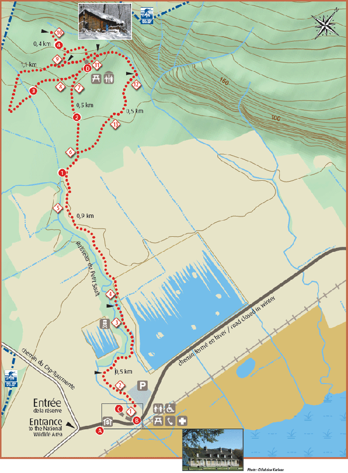
Map: © Environment Canada, 2014. Photo: © Fabrice Kerleau, 2014.
Long description for Bird Feeders Network Map
Map of Quebec’s Cap Tourmente National Wildlife Area bird feeders network. Map shows the winter hiking trails in the Petite-Ferme sector of Cap Tourmente National Wildlife Area territory. The trail entrance has a toll kiosk, accessible washrooms, a picnic area, a first-aid area and telephone. Another washroom location and picnic area can be found at the Érablière shelter (see Red Circle D).
Petite-Ferme sector
The Petite-Ferme sector points of interest and services are :
- Red Circle A
- Toll kiosk (proceed in eastern direction from the entrance to the National Wildlife area for a short distance)
- Red Circle B
- Petite-Ferme Service Area (proceed in eastern direction for a short distance from Red Circle A, toll kiosk)
- Red Circle C
- Workshop (proceed in northwest direction for a short distance from Red Circle B, service area)
- Red Circle D
- Érablière shelter (proceed in northwest direction for 4.6 kilometres from Red Circle B, service area)
- Diamond 1 to 13
- Bird feeders (found throughout the trail at various locations)
The winter hiking trails are :
- Red Circle 1
- Le Petit-Sault, Green Circle, 3.3 km, 1 hour 30
- Red Circle 2
- L’Érablière, Yellow Square, 4.6 km, 2 hour 15
- Red Circle 3
- L’Aulnaie, Yellow Square, 5.2 km, 2 hour 30
- Red Circle 4
- La Prucheraie, Yellow Square, 5.0 km, 2 hour 30
Distance are round-trip from the starting point of the sector. Estimated time is at a walking pace.
Please help us protect and maintain the site! We ask you to:
- Respect the opening hours.
- Stay on the marked trails at all times.
- Do not damage the vegetation.
- Take your garbage with you when you leave.