
Spiers Lake National Wildlife Area management plan
Long description for the cover page
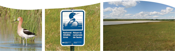
Coloured photograph of an American Avocet standing in the water at Spiers Lake. Photograph is accredited to Todd Kemper.
Coloured photograph of Environment Canada’s Canadian Wildlife Service signboard.
Coloured landscape photograph of an open grass field with Spiers lake on the left. Photograph is accredited to Todd Kemper.
Table of contents
- Document information
- About Environment Canada Protected Areas & Management Plans
- Spiers Lake National Wildlife Area
- 1. Site description
- 2. Ecological resources
- 3. Goals and objectives
- 4. Management challenges and threats
- 5. Management approaches
- 6. Prohibited activities and entry
- 7. Health & safety
- 8. Enforcement
- 9. Plan implementation
- 10. Literature cited
List of figures
- Figure 1. Location of Spiers Lake National Wildlife Area
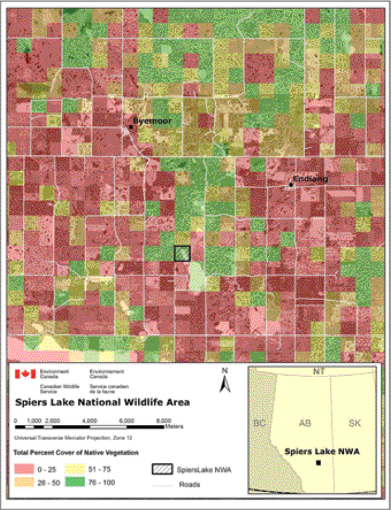
- Figure 2. Remaining native prairie vegetation in the Spiers Lake Region in 1992/1993.
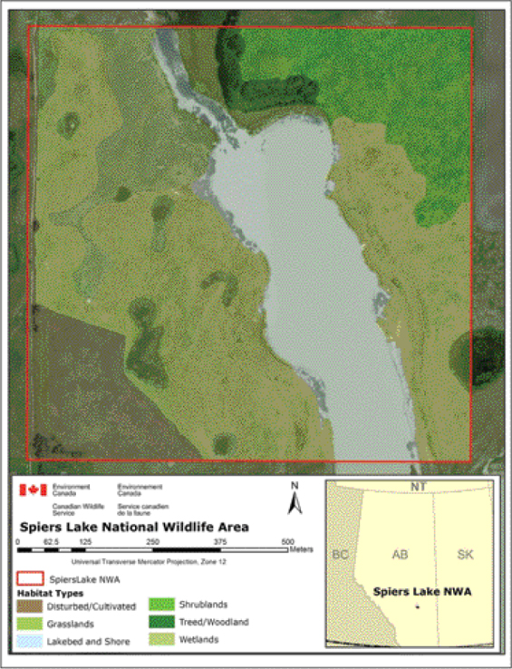
- Figure 3. Map of major habitats on Spiers Lake National Wildlife Area
- Figure 4. Spiers Lake National Wildlife Area showing area of prior cultivation and location of adjacent water impoundment.
Document information
Acknowledgements:
Olaf Jensen contributed content from a previous version of this plan. Contributions through reviews and consultation were made by Ron Bennett (Environment Canada-Canadian Wildlife Service), Olaf Jensen (Environment Canada-Canadian Wildlife Service), Susanne Emond (Environment Canada-Canadian Wildlife Service), and Darcy Henderson (Environment Canada-Canadian Wildlife Service).
Copies of this Plan area available at the following addresses:
Environment CanadaInquiry Centre
10 Wellington, 23rd Floor
Gatineau QC K1A 0H3
Toll Free: 1-800-668-6767 (in Canada only)
Email: enviroinfo@ec.gc.ca Environment Canada - Canadian Wildlife Service,
Room 200, 4999 - 98 Ave,
Edmonton, Alberta, T6B 2X3
Website for Environment Canada Protected Areas
Prepared by: © Todd Kemper
Information contained in this publication may be reproduced, in part or in whole, and by any means, for personal or public non-commercial purposes, without charge or further permission, unless otherwise specified.
You are asked to:
- Exercise due diligence in ensuring the accuracy of the materials reproduced;
- Indicate both the complete title of the materials reproduced, as well as the author organization; and
- Indicate that the reproduction is a copy of an official work that is published by the Government of Canada and that the reproduction has not been produced in affiliation with or with the endorsement of the Government of Canada.
Commercial reproduction and distribution is prohibited except with written permission from the author. For more information, please contact Environment Canada’s Inquiry Centre at 1-800-668-6767 (in Canada only) or 819-997-2800 or email to enviroinfo@ec.gc.ca.
Photos: © Todd Kemper (American avocet and landscape); and Environment Canada, Canadian Wildlife Service (signboard)
Aussi disponible en français
About Environment Canada Protected Areas & Management Plans
What are Environment Canada Protected Areas?
Environment Canada establishes marine and terrestrial National Wildlife Areas and Migratory Bird Sanctuaries for the purposes of conservation, research, and interpretation. These areas are established to protect migratory birds, species at risk, and other wildlife and their habitat. National Wildlife Areas are established under the authority of the Canada Wildlife Act and are, first and foremost, places for wildlife.
What is the size of the Environment Canada Protected Areas Network?
The current Protected Areas Network consists of 54 National Wildlife Areas and 92 Migratory Bird Sanctuaries comprising almost twelve million hectares across Canada.
What is a management plan?
Management plans provide the framework in which management decisions are made. Management plans are intended to be used by Environment Canada staff to guide decision making, especially with respect to permitting. Management is undertaken in order to maintain the ecological integrity of the protected area and to maintain the attributes for which the protected area was designated. Canadian Wildlife Service (CWS) prepares a management plan for each protected area in consultation with the public and other stakeholders.
The management plan specifies activities that are allowed and identifies other activities which may be undertaken under the authority of a permit. Management plans may also specify how and where to make habitat improvements. Management plans must respect Aboriginal rights and allowable practices specified under land claims agreements. Further, measures carried out for the conservation of wildlife must be consistent with any law respecting wildlife in the province in which the lands are situated.
What is Protected Area Management?
Management includes monitoring wildlife, maintaining and improving wildlife habitat, periodic inspections of facilities, enforcement of regulations, and the maintenance of signs and other infrastructure. Research is also an important function of protected areas; hence, Environment Canada staff carries out or coordinates research at some sites.
Each protected area is managed in accordance with the specific characteristics of the site and of the local area but shares the same overall management strategy: to protect and maintain habitat vital for wildlife and to improve habitat when necessary for wildlife use.
The series
All National Wildlife Areas administered by Environment Canada will have a management plan. These management plans will initially be reviewed 5 years after the approval of the first plan, and every 10 years after.
To learn more
To learn more about Environment Canada’s protected areas, please visit our website or contact the Canadian Wildlife Service.
Spiers Lake National Wildlife Area
Spiers Lake National Wildlife Area (NWA) is located in south-central Alberta. This 64.7 hectare (ha) parcel is situated in the transition zone between aspen parkland and prairie grassland, and hosts several diverse flora and fauna communities. It supports one of the few remaining (uncultivated) examples of plains rough fescue grassland on hummocky disintegration moraine in Canada, and contains an alkaline lake bed that periodically fills and dries in response to recent climate patterns. When precipitation is adequate, several small wetlands are found in the depressions of the knob and kettle topography of this landscape. Because the topography and soils limit cultivation, native upland habitat types are also present in much of the surrounding area.
Spiers Lake NWA is an historic breeding site for Piping Plover, and is used regularly by other shorebirds and songbirds. It provides good habitat for shorebirds and other flora and fauna that rely on saline wetlands. Several songbird species have been observed to nest in the grassland and woodland including Chestnut-collared Longspur. Mammals observed in the area include meadow voles, ground squirrels, badgers, skunks, coyotes, white-tailed and mule deer.
Spiers Lake NWA is managed primarily to maintain or enhance the native rough fescue plant communities and wildlife populations. In particular, efforts are devoted to maintaining the area for Piping Plover, other shorebirds, grassland songbirds, and waterfowl that presently use the area. Management activities involve monitoring of wildlife populations and habitat conditions, fencing of boundaries and posting of signs.
Spiers Lake NWA is protected and managed according to the Wildlife Area Regulations under the Canada Wildlife Act. The Wildlife Area Regulations outline specific prohibited activities (such as hunting, fishing, damaging or removing plants, agricultural and recreational activities, etc.), unless notices permitting specific activities are posted or a person has obtained a permit. All activities within Spiers Lake NWA require a permit. For more information on authorizations and prohibited activities in a national wildlife area, consult the NWA Management and Activities section.
1. Site description
Spiers Lake National Wildlife Area (NWA) is located southwest of Endiang, Alberta, approximately 200 kilometres (km) south-southeast of Edmonton. The NWA is comprised of approximately 46% grassland (including shrub-encroached grasslands), 24% lake bed/shore, 16% wetland, 12% disturbed/cultivated land, and 2% treed land.
The NWA lands were acquired by Environment Canada from Parks Canada, who had declared the lands surplus in 1980, and were designated as a National Wildlife Area in 1982. The NWA protects a vestige of upland fescue prairie and has or could provide habitat for several species at risk including Piping Plover (Charadrius melodus circumcinctus), Alkaline Wing-nerved Moss (Pterygoneurum kozlovii), Sprague’s Pipit (Anthus spragueii), Long-billed Curlew (Numenius americanus), Short-eared Owl (Asio flammeus), Chestnut-collared Longspur (Calcarius ornatus), and Common Nighthawk (Chordeiles minor). Spiers Lake NWA is an Internation Union for Conservation of Nature (IUCN) Category IV Protected Area. The site is managed by Environment Canada, Canadian Wildlife Service (CWS).
Spiers Lake NWA is located in rural south-central Alberta amidst agricultural lands that are used for crop production and cattle grazing.
| Category | Information |
|---|---|
| Protected Area Designation (PA) | National Wildlife Area |
| Province/territory | Alberta |
| Latitude/longitude | 51°57’ 112°30’ |
| Size (hectare (ha)) | 64.7 |
| Protected Area (PA) designation criteria | Historic: Protection of Migratory Birds and Unique wildlife habitats Current: 2 - Wild Flora and Fauna - supports native prairie species, potentially supports species at risk 3 - Unique wildlife habitats - a vestige of northern fescue prairie |
| PA Classification System | B (medium-high) - site connectivity. Provides additional extent to Chain Lakes Important Bird Area (IBA) |
| IUCN Classification |
Category IV - Habitat Management Area |
| Order in Council Number | P.C. 1982-2855 |
| Directory of Federal Real Property (DFRP) number | 15289 |
| Gazetted | 1982 |
| Additional designations | Included in: Environmentally Significant Area (Alberta ESA) 274); Chain Lakes Important Bird Area (AB026) |
| Faunistic and floristic importance | Plains Rough Fescue (Festuca hallii) grasslands are rare vegetation communities of very limited extent that are of conservation concern. Three or more provincially rare plant species: Marsh Alkali Aster (Almutaster pauciflorus), Marsh Feltwort (Lomatogonium rotatum), and Pale Blue-eyed Grass (Sisyrinchium septentrionale). Historic breeding site for Piping Plover and Chestnut-collared Longspur; provides habitat for, Short-eared Owl, Common Nighthawk, Sprague’s Pipit, Long-billed Curlew, and Alkaline Wing-nerved Moss. Breeding area for numerous prairie shorebirds, waterfowl, and songbirds. |
| Invasive species | Common Caragana (Caragana arborescens), Perennial Sow-thistle (Sonchus arvensis) Table Footnotea, Canada Thistle (Cirsium arvense variation (var.) arvense) Table Footnotea, Crested Wheat-grass (Agropyron pectiniforme), Smooth Brome (Bromus inermis var. inermis), Russian Pigweed (Axyris amaranthoides), Shepherd’s Purse (Capsella bursa-pastoris), Lamb’s Quarters (Chenopodium album), Annual Hawk’s-beard (Crepis tectorum), Flixweed (Descurania sophia), Quack Grass (Elymus repens), Red Fescue (Festuca rubra var. rubra), Summer-cypress (Kochia scoparia), Yellow Alfalfa (Medicago sativa subspecies (subsp.) falcata), Blue Alfalfa (Medicago sativa subsp. sativa), White Sweet-clover (Melilotus alba), Yellow Sweet-clover (Melilotus officinalis), Common Plantain (Plantago major var. major), Canada Bluegrass (Poa compressa), Kentucky Bluegrass (Poa pratensis var. pratensis), Wild Buckwheat (Polygonum convolvulus), Curled Dock (Rumex crispus),Common Dandelion (Taraxacum officianale), Stinkweed (Thlaspi arvense), Common Goat’s-beard (Tragopogon dubius). |
| Species at Risk | At least seven species at risk listed on Schedule 1 of the Species at Risk Act (SARA) have been observed: Piping Plover (Endangered) regularly used Spiers Lake NWA in the past, but have not been reported from the site since 1994. The area still provides suitable habitat and may continue to be used infrequently. Chestnut-collared Longspur (Threatened) also bred within the NWA in the past but have not been recorded recently. Alkaline Wing-nerved Moss (Threatened) has been recorded from the shoreline of Spiers Lake. Short-eared Owl (Special Concern), Common Nighthawk (Threatened), Sprague’s Pipit (Threatened), and Long-billed Curlew (Special Concern) have also been reported from the NWA. |
| Management Agency | Canadian Wildlife Service, Environment Canada |
| Public Access & Use | Limited / Infrequent. No facilities for public access are provided. |
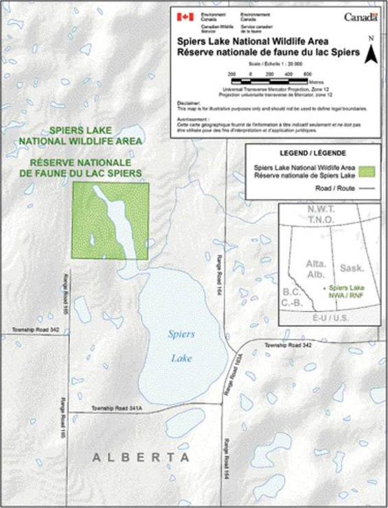
Long description for Figure 1
Map of the location of Spiers Lake NWA in relation to Alberta. The NWA is represented by a green square at the northern-most point of Spiers Lake. The map is measured in metres.
1.1 Regional context
Spiers Lake NWA is located in south-central Alberta, in the county of Stettler No.6, approximately 160km North East (NE) of Calgary. The NWA is situated on undulating prairie along the northern edge of the North American Great Plains where the dry grasslands of the south meet the treed aspen parkland to the north. The area is located in the Moist Mixed Grassland Ecoregion of southern Alberta Footnote1. The climate of this Ecoregion is characterized by moderately warm summers and relatively cold winters. The mean winter and summer temperatures are -11 degree Celsius(°C) and +15.5°C respectively. Mean annual precipitation ranges from 350 - 400 millimetres (mm), approximately 70% of which occurs during the growing season (May to September). Precipitation is not adequate to support tree growth on well-drained sites, and the landscape is characterized by grasslands and shrublands dotted with aspen-fringed depressions and wetlands. Mean annual precipitation for meteorological stations in the vicinity of Spiers Lake ranges from 367.6mm at Drumheller (~59 km to the South West (SW)) to 390mmat Castor (39 km to the NE) and 401mm at Coronation (57 km to the East North East (ENE)) Footnote2 . Local temperature extremes reported from Coronation (the nearest meteorological station that reports temperature) are +37.8°C on August 5, 1961 and -44°C on January 25, 1950 Footnote2. The greatest single day precipitation recorded at Castor was 71.6mm on June 15th1973 Footnote2.
The fescue grasslands of the region are among the most altered of all ecosystems in Canada. The historic extent of Plains Rough Fescue grasslands on the Canadian prairies has never been adequately reconstructed, but some have estimated that as little as 5% of their original extent remains (Trottier, 1992; Grilz and Romo 1995). Spiers Lake NWA is one of relatively few undisturbed sites of native prairie grassland in the region (Figure 2). Most of Canada’s rough fescue prairie was converted to cultivation in the early part of the 20th Century as settlers took advantage of the fertile, mostly treeless grasslands that had been shaped by centuries of grazing and fire. Much of the land that remained unbroken was too hummocky to be efficiently cropped and was instead used for cattle production or abandoned. The fescue grasslands of this region are capable of producing more forage for cattle than the drier mixed grasslands to the south, but are also more susceptible to overgrazing, and a relatively high percentage of the area suffered from over-grazing in earlier years.
Today, agriculture remains the primary land use in the region and working farms and ranches in the area continue to supply demand for annual crops and beef cattle. The extent of landscape alteration as a result of cultivation for annual crop production limits the ability of Spiers Lake NWA to support viable populations of some native prairie species, including Species at Risk.
Spiers Lake NWA lies within the Red Deer River sub-basin of the South Saskatchewan River Basin. Many of the lakes in the region of the NWA (including Spiers Lake), are isolated from the contemporary Red Deer River and have no surface water connection to the broader watershed. The balance between evaporation and inflow in these lakes makes many of them saline; in periods of prolonged drought such lakes can be hyper-saline or even completely dry salt flats.
Long description for Figure 2
Map of the remaining native prairie vegetation in the Spiers Lake NWA region in 1992-93. The various colours represent the percentage cover of native vegetation in the surrounding area; the solid grey lines represent roads. The map is measured in meters.
1.2 Historical background
Prior to 1900, this area of Alberta area was most recently inhabited by the Blackfoot First Nations. Blackfoot culture was heavily influenced by their relationship with Plains Bison (Bison bison bison) and included sophisticated habitat management strategies such as periodic planned burning of grasslands to influence the movement of bison herds. Unlike people further north, the Blackfoot in the area were not initially affected by the expansion of the fur trade in the early part of the 19th century, due primarily to the lack of tradable pelts in the region. As a result, forts, missions, and RCMP outposts were not established in the Stettler area and the Aboriginal population in this region remained virtually undisturbed until the 1837 smallpox epidemic. The smallpox epidemic of 1837 decimated the Blackfoot population, by some accounts killing as many as two thirds of the total population. The signing of Treaty 7 Footnote3in 1877 and the near extermination of the bison ultimately brought about the end of a traditional way of life and the beginning of settlement on reserves for the Blackfoot Nations. By 1890 the market hunting of bison had driven the species into near extinction across North America and few if any individuals persisted in Canada (COSEWIC 2004).
European settlements were not well established in the region until the 20th century, despite the passing of the Dominion Lands Act in 1872 to encourage homesteading. The construction of the Calgary to Edmonton railway in 1891 and the Stettler railway in 1905 brought a dramatic increase in European settlement within the region. Some Canadian homesteaders who settled in the area served in the second Boer War (1899-1901) and were each entitled to receive a half-section of land in return for their service.
The quarter-section of lands (NW17-34-16-W4) that now comprise Spiers Lake NWA were homestead lands given out in the early 1900s to Mr. Frank Carless Sr., who also homesteaded on the adjacent quarter-section to the south of the NWA (SW17-34-16-W4). No patent (land title) was ever issued for the northwest quarter. Mr. Carless did receive title for the southwest quarter, however, and farmed in the area until 1914, when he returned to Europe to serve Canada in the First World War. After the war Mr. Carless returned to the adjacent southwest quarter and farmed the site until 1927 when drought and hail forced the family to abandon their land and move to nearby Byemoor (Campbell 1975). Because the northwest quarter of Section 17 was reserved under the Soldier Settlement Act, the land (along with the bed and shore of that portion of Spiers Lake that lies within the quarter section) was retained by the Federal Government when other crown lands were transferred to the province in accordance with The Alberta Natural Resources Act (1930) Footnote4 . In 1953, the Department of Veterans Affairs advised that they no longer had an interest in the land and the parcel was administered as unpatented crown land by the Department of the Interior.
Parks Canada took over administration of the land in 1973 until it declared the land surplus to its interests in 1980. The land was transferred to Environment Canada on December 31st, 1980. At the time of transfer, Environment Canada stated that the site “would provide an ideal focal point for habitat development and goose population and survey work we have currently undertaken. In addition, a considerable area on this site is still vegetated with a native rough fescue…which is being rapidly destroyed by overgrazing and intensification of agricultural activities.” Footnote5 .
Spiers Lake National Wildlife Area was created by an Order in Council - Wildlife Area Regulations amendment on the 15th of January, 1982.
1.3 Land ownership
The quarter-section of land that comprises the NWA is a non-titled parcel (non-patent) of Crown land administered by the Canadian Wildlife Service, Environment Canada.
1.4 Facilities & infrastructure
There are no facilities within the Spiers Lake NWA. However there is fencing along the north and east boundary to control access by livestock on adjacent agricultural land. Farm equipment and materials from the last century remain abandoned at the southwest corner of the NWA. There are small sections of old fencing in disrepair along the south boundary and west boundary, as well as surrounding portions of the previously cultivated field. Some NWA signage and sections of fence along the south boundary are misplaced and inaccurately reflect the legal boundary of the NWA. A three-phase power line runs along the western boundary of the property.
2. Ecological resources
2.1 Terrestrial and aquatic habitats
Spiers Lake NWA is located in the Moist Mixed Grassland Ecoregion of southern Alberta Footnote6.
The NWA is situated in an area of hummocky stagnation moraine deposited during the Wisconsin glacial episode. The topography of the immediate area is undulating, with weakly developed and irregular knob and kettle formations (often referred to as prairie potholes). In immediately adjacent quarter-sections to the east and northeast the knob and kettle topography is more strongly developed; the lake itself is part of an ancient valley that was part of the Red Deer River valley prior to most recent glaciation. The bedrock underlying the NWA is part of the upper Cretaceous Horseshoe Canyon formation and is composed of mudstones, sandstones, and shales. Upland soils are primarily dark brown Chernozems.
The NWA itself is a small remnant of northern fescue prairie that is bisected by a shallow arm of Spiers Lake, a small evaporative lake that experiences strong water fluctuations in response to variation in rainfall and temperature. The arm of Spiers Lake that extends into the NWA is often completely dry by late summer in hot and dry years and in periods of prolonged drought.
Terrestrial habitats consist primarily of Plains Rough Fescue (Festuca hallii) grasslands (approximately 46% of the total NWA area) that are dominated by two distinct and provincially rare vegetation types: a pure Plains Rough Fescue grassland community (with forbs interspersed) and a Plains Rough Fescue - Western Porcupine Grass (Stipa curtiseta) dominated community. Interspersed are areas of native shrubs, such as Snowberry (Symphoricarpos occidentalis), Wild Rose (Rosa acicularis) and Silverberry (Elaeagnus commutata). In the north east portion of the NWA exclusion of natural processes (grazing and fire) has allowed the cover of these shrubs to increase since the establishment of the NWA. Dense clumps of Trembling Aspen (Populus tremuloides) and Willow (Salix spp.) dominate a small area (approximately 2%) of the north-central portion of the NWA lakeshore. A small portion (4.6 ha) of the NWA was previously cultivated as an extension of cropped land in the adjacent quarter section. This area was subsequently planted to dense cover suitable for haying (primarily Smooth Brome and Alfalfa) following the establishment of the NWA. Air photos also reveal that ‘slough hay’ was periodically taken off of wetlands within the NWA prior to its establishment. A small horse-drawn plough that sits at the edge of the hay field is testament to the era in which this small field was originally broken. Other abandoned farm equipment in the southwest corner of the NWA dates to the 1930s and suggests that the field has not been actively cropped (other than periodic haying) in many decades. In total approximately 12% of the total NWA area is disturbed or physically altered by human activities (including the previous cultivated field, road allowance, and planted shelterbelt at the abandoned farm site).
Aquatic habitats consist primarily of the shallow alkaline lake basin (approximately 24% of the total NWA area) along with adjacent wetlands meadows (approximately 10.5% of the total NWA area) that are dominated by alkaline tolerant grasses, sedges and forbs. A few small isolated basin wetland areas are scattered throughout the NWA and account for approximately 2.8% of the total NWAarea.
Long description for Figure 3
A map of major habitats in the Spiers Lake NWA. The varied habitats are listed as disturbed/cultivated, grasslands, lakebed and shore, shrublands, tree/woodland, and wetlands, each assigned a different colour. The map is measured in metres.
2.2 Wildlife
Sixty species of birds have been observed on the NWA. Survey data from 1981 and 1984 indicate that the north-central portion of the NWA, especially the wetland and woodland areas, support the greatest diversity of birds. The shoreline and lakebed provide good habitat for shorebirds such as Willet (Tringa semipalmata), Kildeer (Charadrius vociferous), and Marbled Godwit (Limosa fedoa), as well as those that prefer alkaline waters such as American Avocet (Recurvirostra americana) and Wilson’s Phalarope (Phalaropus tricolor). In wet years dabbling ducks such as Blue-winged Teal (Anas discors), Northern Pintail (Anas acuta), and Northern Shoveler (Anas clypeata) inhabit the NWA and forage in the shallow waters of the lake and nearby wetlands. Eleven species of mammals, representing six families are common to the NWA. Small mammals include Thirteen-lined Ground Squirrel (Spermophilus tridecemlineatus), Franklin’s Ground Squirrel (Spermophilus franklinii), Deer Mouse (Peromyscus maniculatus) and Meadow Vole (Microtus pennsylvanicus). Carnivores reported from the NWA include Coyote (Canis latrans), Striped Skunk (Mephitis mephitis), and Badger (Taxidea taxus). Whitetail deer (Odocoileus virginianus) are common in the area. This list of wildlife is a result primarily of casual observations; no systematic survey or comprehensive inventory has been completed.
2.3 Species at risk
Spiers Lake NWA supports provincially rare plant species and plant communities, and has the potential to support several species at risk designated under Canada’s Species at Risk Act (Table 2). Six species at risk listed under Schedule 1 of SARA have been recorded from within the NWA, and one has been recorded from Spiers Lake outside of the NWA and likely occurs within the NWA as well.
Piping Plover is currently listed as Endangered and historically nested within Spiers Lake NWA. Preferred habitat for Piping Plover is open sandy or gravelly shorelines of alkali lakes. In 1984, seven adult and five young Piping Plovers were observed on Spiers Lake within the boundaries of the NWA. Periodic observations of Piping Plover along the shores of Spiers Lake continued until the most recent reported sighting from the area in 1994. No systematic or comprehensive surveys of Spiers Lake have been conducted, however, and Piping Plover may still use Spiers Lake in years where the water level and shoreline conditions are favorable. Year to year fluctuation in lake level maintains Piping Plover habitat by periodically flooding (and killing) vegetation that encroaches into shoreline habitats in drier years (Environment Canada 2006). The Alberta provincial government recognizes Spiers Lake as a Piping Plover waterbody and imposes some limitations on industrial activities in the surrounding area.
Like Piping Plover, Alkaline Wing-nerved Moss (Threatened) relies on seasonally wet alkaline flats along the edge of ponds or lakes where vegetation is short and patchy. The species has been collected from the south east shores of Spiers Lake (outside the NWA), and likely occurs within the NWA as well. Although it is considered rare to uncommon throughout most of its range, recent surveys suggest that the distribution of this species in prairie Canada is wider than previously thought (Canadian Wildlife Service 2008 unpublished data).
Chestnut-collared Longspur (Threatened) were identified on breeding territories within Spiers Lake NWA in 1981 but have not been reported from the site since. This species has suffered a severe decline in Canada over the past three decades, primarily due to loss and fragmentation of native grasslands (COSEWIC 2009). Chestnut-collared Longspur require native grasslands and prefer sites with relatively short vegetation and recent grazing pressure (Davis 2005). Due to the exclusion of fire and grazing from the NWA it is uncertain whether habitat conditions remain suitable for Chestnut-collared Longspur today.
Sprague’s Pipit (Threatened), Long-billed Curlew (Special Concern), Short-eared Owl (Special Concern), and Common Nighthawk (Threatened) have been reported from the NWA, however, neither species is known to have nested within the site recently. The grasslands of Spiers Lake NWA likely provide good habitat for Short-eared Owl and it is possible that the species has nested within the site undetected given that very few surveys have been conducted. Short-eared Owl typically nest in relatively dense open habitats, such as the fescue grasslands provided by the NWA, selecting strongly amongst suitable sites for those that are in close proximity to abundant small mammal populations (COSEWIC 2008).
Three provincially rare plant species have been identified within Spiers Lake NWA. Marsh Alkali Aster (Almutaster pauciflorus) - also known as Few-flowered Aster - is a small herbaceous perennial that grows across much of the great plains in moist alkaline environments. It is currently known from fewer than 40 locations in Alberta (ACIMS 2011). Marsh Feltwort (Lomatogonium rotatum) is a slender annual that grows in moist conditions and is tolerant of alkalinity; unlike Marsh Alkali Aster it has a primarily montane and northern range with relatively few occurrences on the plains south of the boreal forest. Marsh Feltwort is known from fewer than 30 locations in Alberta (ACIMS 2011). Pale Blue-eyed Grass (Sisyrinchium septentrionale) is a relatively widespread but uncommon plant of prairie wetland margins. It is considered globally vulnerable (NatureServe 2011) and in Alberta it is known from roughly half of its former range, with many extant populations thought to be potentially at risk from land use change and urban expansion (ACIMS 2011).
In addition to provincially rare plant species, two provincially rare plant communities are also known from Spiers Lake NWA. Both are Plains Rough Fescue dominated communities that are considered rare and of conservation concern due to the limited remaining extant of native Plains Rough Fescue grassland in Alberta.
| Common Name Birds |
Scientific Name Birds |
SARA Table Footnoteb Birds |
SARA Schedual Table Footnotec Birds |
Provincial Table Footnoted Birds |
|---|---|---|---|---|
| Piping Plover | Charadrius melodus circumcinctus | Endangered (EN) | I | EN |
| Short-eared Owl | Asio flammeus | Special Concern (SC) | I | NS |
| Common Nighthawk | Chordeiles minor | Threatened (TH) | I | No Status (NS) |
| Sprague’s Pipit | Anthus spragueii | TH | I | NS |
| Long-billed Curlew | Numenius americanus | SC | I | NS |
| Chestnut-collared Longspur | Calcarius ornatus | TH | I | NS |
| Common Name Plants |
Scientific Name Plants |
SARA Table Footnoteb Plants |
SARA Schedual Table Footnotec Plants |
Provincial Table Footnoted Plants |
|---|---|---|---|---|
| Alkaline Wing-nerved Moss | Pterygoneurum kozlovii | Threatened (TH)) | I | - |
| Marsh Akali Aster | Almutaster pauciflorus | No Status (NS) | No Schedule (NS) | 6-80 hectare or few (S2S3 |
| Marsh Feltwort | Lomatogonium rotatum | NS | NS | S2S3 |
| Pale Blue-eyed Grass | Sisyrinchium septentrionale | NS | NS | 21-80 hectare or restricted range (S3) |
| Plains Rough Fescue - Western Porcupine-grass community | Festuca hallii - Stipa curtiseta | NS | NS | S2S3 |
| Plains Rough Fescue community | Festuca hallii | NS | NS | S1 |
3. Goals and objectives
3.1 Vision
The long-term vision for Spiers Lake National Wildlife Area is conservation; to maintain and enhance habitats for native wildlife and plants, including species at risk.
3.2 Goals and objectives
Spiers Lake NWA is an IUCN Category IV Protected Area with the goal to protect habitat and species through management intervention. The primary goal of this management plan is to restore and sustain the native habitats and associated wild species of Spiers Lake NWA, and their supporting natural processes. The native grasslands of the NWA include remnants of a Plains Rough Fescue vegetation community that once spanned a great expanse of Canadian prairie. Many of the grassland obligate species that were once numerous and widespread are now at risk, and the conservation or restoration of grassland habitats is vital to recovery efforts. For this reason habitats at Spiers Lake NWA will be conserved in, or returned to, as natural a state as possible. Previously excluded or altered natural processes, such as grazing and fire, will be restored or simulated where appropriate and feasible, and other natural processes, such as lake level fluctuation, will be allowed to continue to occur.
Goal 1: Native grasslands will be maintained or enhanced in accordance with beneficial management practices for the benefit of wildlife, especially species at risk. To achieve this goal the following objectives have been identified:
- 50% of upland terrestrial habitats will be in a condition of range health deemed “healthy” or “healthy with problems” (cf. Adams et al 2009) in the long term Footnote7 .
- Natural processes, such as grazing and fire will be reintroduced or mimicked to the extent possible
- Total cover of targeted non-native plant species (Caragana, Smooth Brome) will be reduced
- The total cover of Snowberry in native grasslands will be reduced.
- Previously cultivated or heavily disturbed habitats, including the hay field and shelterbelt will be restored to a natural state if feasible. Cover of woody non-native species at the original homestead site will be reduced by 95% from 2012 levels.
Goal 2: Habitats will support native flora and fauna that reflect the contemporary climate and recent site history/management actions. To achieve this goal the following objectives have been identified:
- Terrestrial habitats will support assemblages of breeding migratory songbirds that are representative of natural grasslands of similar size in varying condition or successional state.
- Shoreline habitats will support breeding shorebird populations that are within the natural range of variation for this site.
- Encroachment of non-native plants into exposed lake bed during prolonged dry periods will be controlled
3.3 Evaluation
Annual monitoring will be performed within the limits imposed by financial and human resources. The management plan itself will be reviewed in five years time and every ten years after that. Evaluation will take the form of an annual review of monitoring data obtained from the monitoring and research projects outlined below. This data and the annual review will be used to inform future management as well as to evaluate federal contributions towards accomplishing the mandates specific to EC for which the protected area was established.
4. Management challenges and threats
4.1 Isolation and adjacent land use
Fragmentation and alteration of native habitats is the most significant threat to ecological integrity in the region of Spiers Lake NWA. The fragmentation of vast expanses of grasslands into smaller compartments with differing use and management has dramatically altered the regional landscape and is a long-term threat to the viability of the NWA and the flora and fauna it supports. The small size and varied adjacent land use inevitably led to the exclusion of natural fire and grazing from the NWA because the site itself is not large enough to sustain such processes in isolation from the surrounding landscape.
Some of the surrounding lands remain in their native condition primarily because there have not been any strong economic incentives to cultivate these marginal lands. The highest and best use of the surrounding land from an agronomic perspective has been the use of the land as native grass forage for the production of cattle. At present these lands contribute to the total area of available habitat in the vicinity of the NWA. Future changes in market conditions or climate, while not predictable, may provide incentive for the conversion of these lands to cereal crop, tame forage, biomass/bio-fuel production, or other uses. Further conversion of adjacent lands would increase the isolation of the NWA and erode the value of the site for native prairie wildlife species that require large areas of suitable habitat.
4.2 Alteration or exclusion of natural processes
The alteration or exclusion of natural processes from the NWA has affected the terrestrial habitats of the site and the wildlife they support, and is a present-day management challenge. Fire is a necessary and natural process in grassland ecosystems and is one of the factors that shapes the structure and composition of Plains Rough Fescue communities (Romo 2003). These grassland communities also evolved under the influence of grazing from large native herbivores such as Plains Bison that have since been eradicated.
Alteration of natural processes may also have influenced shoreline and lakebed habitats. Lake level fluctuation is a natural climate-driven process that helps to maintain shoreline habitats used by Piping Plover and other shorebirds by periodically flooding and killing encroaching vegetation. A small intermittent stream that drains into Spiers Lake (outside of the NWA) is altered by a water diversion structure operated under license from Alberta Environment in the adjacent quarter-section (Figure 4). It is unknown if the resulting flow disruption has affected the lake levels or water fluctuation regime within the lake basin.
4.3 Non-native and invasive species
Invasion of non-native plant species, including those introduced for agricultural use in the surrounding lands (as well as the previously cultivated portion of the NWA itself) is a factor in degradation of native habitats within the NWA. The continuing invasion and spread of non-native alien plant species constitutes a long-term threat to the ecological integrity of the site.
4.4 Petrochemical development
The Horseshoe Canyon formation, atop which the Spiers Lake NWA sits, contains extensive coal seams, and has recently been a primary focus for Coal Bed Methane (CBM) production in Alberta. Subsurface rights at Spiers Lake NWA are held by the federal crown and are not available for development. To date no CBM wells have been drilled in the immediate area, however, changes in technology or market conditions could lead to increased interest in the development of CBM resources in the future.
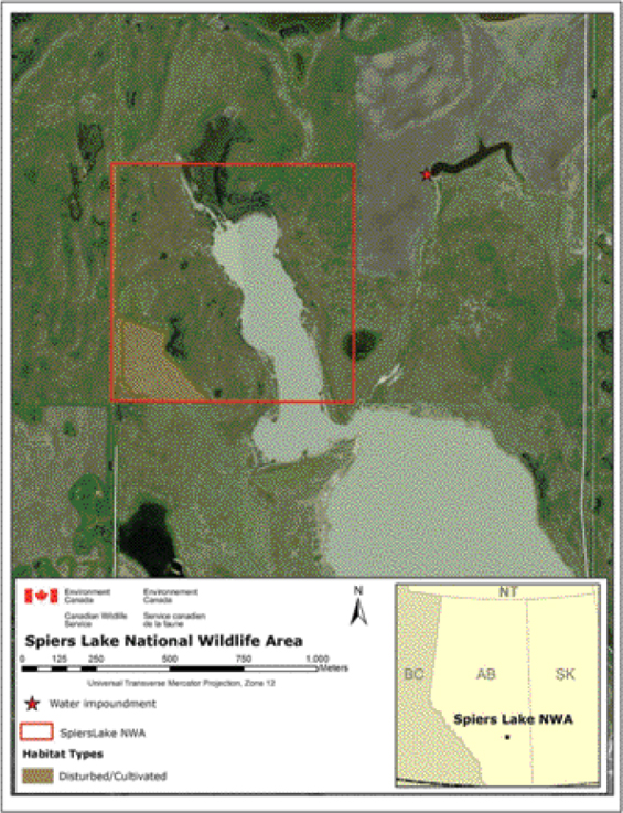
Long description for Figure 4
Map showing the area of prior cultivation, and location of adjacent water impoundment in relation to Spiers Lake NWA. A star is used to locate the water impoundment on the map, i.e. an area northeast of Spiers Lake. A solid, red thin-lined box marks the Spiers Lake NWA; the area that has been disturbed/cultivated is represented in brown. The map is measured in metres.
| Challenges & Threats | Goals & Objectives | Management Approaches |
|---|---|---|
| Isolation and Adjacent Land Use | 1(b) | 5.1.1 restore or mimic natural processes |
| Isolation and Adjacent Land Use | 2(a) | 5.1.3 expand effective management area |
| Exclusion of Natural Processes | 1(a, b, c, d) | 5.1.1 restore or mimic natural processes |
| Exclusion of Natural Processes | 2(a, b) | 5.1.2 - reclaim/restore disturbed habitats 5.2 - wetland/shoreline management 5.4 - wildlife management 5.5 - monitoring 5.6 - research |
| Non-Native and Invasive Species | 1(a, c, e, f) | 5.1.2 - reclaim/restore disturbed habitats |
| Non-Native and Invasive Species | 2(c) | 5.1.3 - expand effective management area 5.3 - alien/invasive plant management 5.5 - monitoring 5.6 - research |
| Petrochemical development | none at present | none at present |
5. Management approaches
This section contains a description of all the possible approaches that could be used in the management of the Spiers Lake National Wildlife Area. However, management actions will be determined during the annual work planning process and will be implemented as human and financial resources allow.
5.1 Grassland habitat management
Habitat management will be directed towards long-term ecological integrity of the important wildlife habitats within the NWA. To the extent possible coarse-filter strategies will be adopted in support of a multi-species approach that recognizes inherent variability and periodicity in ecological conditions as well as in plant and animal communities. Finer-scale habitat management activities will be limited to species-specific actions to reduce the spread and impact of invasive and non-native plants.
5.1.1 Restore or mimic natural processes in grasslands
The primary mechanism for coarse-scale habitat management practices will be the reintroduction (or simulation) of missing natural processes. Prescribed burning and/or prescribed grazing will be used where appropriate and feasible to maintain and enhance the health of native grasslands and control the encroachment of woody and/or non-native invasive species. The fescue grasslands of the Great Plains formed in an environment subject to both grazing and fire (both natural and anthropogenic) and the reintroduction of fire has been promoted as an essential tool for their conservation (Romo 2003).
Reintroductions of fire or grazing must be undertaken carefully. Intense summer fires can cause high mortality of fescue, particularly when long term exclusion of fire and grazing has led to a significant or exceptional accumulation of fuels (e.g., Antos et al. 1983). Despite their evolutionary coexistence with large herbivores, rough fescue grasslands are also highly susceptible to overgrazing (Trottier 1986). It has been suggested that prior to their eradication, Plains Bison typically used the northern fescue grasslands only in the fall and winter months, and that these grass species are thus not well adapted to summer grazing (Johnston and MacDonald 1967). For these reasons careful consideration of proposed management interventions will be made, and a detailed habitat management plan will be developed prior to implementation of any prescribed burning or grazing. Key knowledge gaps to be addressed at this stage include assessments of present-day range health along with pre-settlement fire and grazing regimes. Implementing a grazing program would also require infrastructure investment for fencing, and potentially for water supply (to protect shoreline habitats from damage).
5.1.2 Reclaim/restore previously altered habitats
A small area (~4.6 hectare (ha)) in the southwest corner of the NWA that was previously cultivated and subsequently planted to a dense cover suitable for haying, may be reclaimed to a native species composition. If reclamation is deemed feasible a reclamation plan will be developed. If reclamation is not feasible at this time consideration will be given to allowing an adjacent land owner to periodically hay this area under Permit, as an interim measure until such time as a reclamation plan could be implemented. Haying activities would be timed to prevent disturbance or harm to breeding migratory birds and other wildlife.
5.1.3 Expand effective management area to the extent possible
Because of the limited size of the NWA, consideration will be given to working in strategic partnerships with adjacent land owners to harmonize habitat management practices over a larger land base. If controlled grazing of the fescue communities is deemed necessary, providing adjacent land owners with access to these areas for grazing would provide opportunities to engage in habitat management discussions or agreements.
Acquisition of additional lands, either directly or through collaboration with land trusts could also be considered. Working with other conservation organizations that have the ability and expertise to negotiate conservation easements or land transfers is likely to be the most expedient mechanism for protecting adjacent habitats. The NWA and all adjacent lands are part of the North American Waterfowl Management Plan (NAWMP) Sullivan Lake Target Area (Alberta NAWMP Partnership 2010). NAWMP partner organizations, such as Ducks Unlimited Canada and the Nature Conservancy of Canada, have an ongoing interest in protecting lands within the region and would be ideal candidates for land acquisition partnership.
5.2 Wetlands & shoreline habitat management
Wetland and shoreline management will primarily be through limiting intervention. Wetland habitats will change through time in accordance with water level fluctuations within the NWA. Prior discussions had considered the placement of water control structures between the narrow arm of the lake within the NWA and the main basin of the lake in order to improve waterfowl habitat. However, the artificial manipulation of water levels would potentially eliminate habitat for Piping Plover and other nesting shorebirds and is contrary to the goal of maintaining habitats in a natural state under natural processes. Manipulation of water levels for habitat management purposes will therefore not be pursued.
Eradication or control of native plant species encroaching into shoreline habitats in dry periods will not be contemplated, since periodic water level fluctuations and ice-scour will help to maintain shoreline habitats in the longer-term.
5.3 Alien & invasive plant management
A baseline assessment of the distribution and extent of alien and invasive plants will be conducted for both terrestrial and aquatic/shoreline habitats. Species specific strategies will be used to control targeted species in a manner that will not compromise the health of the surrounding environment. Complete eradication of invasive and alien plants is not realistic, therefore the intent will be to prevent further spread, and control (or eradicate where feasible) priority species in priority habitats. Control means may include mechanical removal, application of appropriate herbicides, or biological means, and will be conducted along with use of natural disturbances or appropriate mimics (e.g., grazing, mowing, or prescribed burning). The efficacy of all weed control actions will be assessed through ongoing monitoring.
Source populations of invasive plants within the NWA, such the former homestead site and the previously cultivated land will be targeted for potential reclamation/restoration.
5.4 Wildlife management
Wildlife management will primarily take the form of the habitat management strategies identified above. The coarse-filter approach to habitat management, with inherent recognition of varying habitat conditions, is designed to support a range of native wildlife species, including species at risk. No specific fine-filter actions are contemplated at this time, and those actions that have taken place in the past (e.g., placement of goose nesting bales within the lake will not be continued).
5.4.1 Species at risk
All management activities will be conducted in accordance with relevant Species at Risk recovery strategies, and will take into consideration critical habitat and activities likely to destroy critical habitat (CH). Ongoing lake level fluctuation and control of invasive shoreline plant species (where needed) will provide suitable habitat for Piping Plover in suitable years. Although the most recent documented sighting of Piping Plover at Spiers Lake was in 1994 there is reason to believe that the species might continue to use the NWA periodically when conditions are favorable (D. Prescott, pers. com.). Annual monitoring, conducted in early June, will determine if Piping Plover are present within the NWA. If breeding plovers are found within the NWA, predator exclosures could be deployed at nest sites to protect the breeding birds and eggs. This strategy would also encourage future nesting, as Piping Plover tend to return to successful territories in subsequent years, and tend to abandon territories following nest destruction (Haig and Oring 1988). If grazing is permitted within the NWA timing restrictions and/or fencing would be required to exclude livestock from shoreline habitats during the breeding season.
Habitat management actions that conserve native grasslands in varying states will provide suitable habitat for grassland birds that are at risk. Some species, such as Chestnut-collared Longspur would benefit from recent disturbance, whereas those that depend on dense grasslands, such as Short-eared Owl, will be benefit from pre-disturbance or mature post-disturbance habitats. By providing this variety of range condition through space and time, Spiers Lake NWA can continue to provide habitat for species at risk.
Critical Habitat may be identified for some or all of the Schedule 1 species within the NWA in the future. If so, the Species At Risk Act requires the preparation of a gazette statement for each species; prohibition against the destruction of critical habitat within the NWA would thus automatically come into force.
5.5 Monitoring
Monitoring will be linked to specific habitat and wildlife management objectives and will be conducted in a manner that provides high-quality information in an efficient manner so that management strategies can be adjusted where necessary.
Piping Plover monitoring will be conducted annually in June to identify if individuals are actively foraging or breeding within the Spiers Lake National Wildlife Area (SLNWA). Regular monitoring will also be implemented for any other Schedule 1 SARA listed species that is identified within the NWA.
An adaptive monitoring protocol will be developed alongside the detailed habitat action plan for SLNWA. Using relevant indicators, the goal of monitoring will be to assess the effectiveness of actions implemented in a timely fashion and to track long-term trends as well as to make adjustments to the work plan when deemed necessary. The following list of indicators, although not an exhaustive list, includes:
- Rangeland health and riparian health
- Extent and/or relative abundance of Plains Rough Fescue in grassland communities
- Extent or relative abundance of specific invasive non-native plants
- Extent and/or relative abundance and total cover of woody species (e.g, snowberry) in fescue grasslands
- Composition of grassland breeding bird communities
- Composition of shoreline bird communities
5.6 Research
Research activities will be considered for permitting only when the research outcomes have the potential for one or more of the following:
- Increasing knowledge related to conservation or restoration of Plains Rough Fescue grasslands
- Characterizing the pre-settlement fire and grazing regimes in the broader Spiers Lake region
- Characterizing the long term patterns of lake level fluctuation at Spiers Lake and the influence of surrounding land uses
- Identifying patterns of natural habitats and/or processes that sustain Species at Risk within the region
- Conserving or restoring natural habitats or processes that promote ecological integrity
- Conserving the wildlife, including species at risk, of the NWA;
- and where the research activities do not detract from the current ecological conditions of the NWA, or efforts to improve those conditions.
Each application will be assessed on its own merit and general adherence to the above topics does not guarantee that a permit will be issued. To obtain a research permit for Spiers Lake National Wildlife Area and to receive instructions on guidelines for research proposals, please contact:
Environment Canada, Canadian Wildlife Service
Prairie and Northern Region
Room 200, 4999-98 Avenue NW
Edmonton, Alberta
T6B 2X3
5.7 Public outreach
There are no interpretation or visitation facilities for the public at Spiers Lake NWA.
6. Prohibited activities and entry
Access to and use of the National Wildlife Area is authorised where notices have been posted or published in local newspapers. Unless posted or published, all activities in a National Wildlife Area are unauthorised. However, a permit may be obtained from the Minister of Environment authorising certain activities to take place.
For the benefit of wildlife and its environment, human activities are minimised and controlled in National Wildlife Areas through the implementation of the Wildlife Area Regulations. These regulations set out activities that are prohibited (subsection 3(1)) and provide mechanisms for the Minister of the Environment to allow for certain activities to take place in National Wildlife Areas that are otherwise considered prohibited. They also provide the authority to the Minister to prohibit entry into National Wildlife Areas.
6.1 Authorizations
Under the Wildlife Area Regulations, the Minister of the Environment may authorise an activity that is prohibited through the issuance of permits and notices issued in local newspaper or posted at the entrance of any wildlife area or on the boundary of any part thereof.
Authorisations may be issued only if the Minister is of the opinion that the activity: is scientific research relating to wildlife or habitat conservation, benefits the wildlife and their habitats or will contribute to wildlife conservation, or is otherwise consistent with the criteria and purpose for which the NWA was established as stated in this management plan. These conditions must be met before the Minister will consider authorising a prohibited activity.
Terms and conditions governing the activity may be added to the authorisations for which the Minister considers necessary that they are added for protecting and minimising the impact of the authorised activity on wildlife and their habitat.
All permit requests must be made (in writing or online) to:
Environment Canada, Canadian Wildlife Service
Prairie and Northern Region
Room 200, 4999 - 98 Ave NW
Edmonton, Alberta
T6B 2X3
6.2 Authorized activities
There are no authorized activities within Spiers Lake NWA that do not require a permit.
6.3 Exceptions
The Wildlife Area Regulations allow for exceptions to the prohibited activities under the following circumstances:
- Activities related to public safety, health or national security, that are authorised by or under another Act of Parliament or activities under Health of Animals Act and the Plant Protection Act for the health of animals and plants;
- Activities related to routine maintenance of National Wildlife Areas, to the implementation of management plans, and enforcement activities conducted by an officer or employee of Environment Canada.
6.4 Other federal and provincial authorizations
Depending on the type of activity, other federal or provincial permits may be required to undertake an activity in the Spiers Lake NWA.
Contact your regional federal and provincial permitting office for more information.
Federal:
Environment Canada, Canadian Wildlife Service, Prairie and Northern Region
Room 200, 4999 - 98 Ave, Edmonton, Alberta, T6B 2X3
Province of Alberta:
Ministry of Sustainable Resource Development, Fish and Wildlife Division,
Provincial Building, 4920 - 51 Street, Red Deer, AB, T4N 6K8
6.5 Prohibition of entry
Under the Wildlife Area Regulations, the Minister may post notices at the entrance of any wildlife area or on the boundary of any part thereof prohibiting entry to any wildlife area or part thereof. These notices can be posted when the Minister is of the opinion that entry is a public health and safety concern and when entry may disturb wildlife and their habitat.
For Spiers Lake NWA, entry on foot is not prohibited.
Note: If there is a discrepancy between the information presented in this document and the notice, the notice prevails as it is the legal instrument prohibiting entry.
7. Health & safety
In the case of environmental emergencies, contact will be made with the Canadian Environmental Emergencies Notification System:
(Environmental Emergencies Website)
Alberta Ministry of Environment
Telephone: 780-422-4505 or 1-800-222-6514
All reasonable efforts will be made to protect the health and safety of the public including adequately informing visitors of any known or anticipated hazards or risks. Further, Environment Canada staff will take all reasonable and necessary precautions to assure their own health and safety and that of their co-workers. However, visitors (including researchers and contractors) must make all reasonable efforts to inform themselves of risks and hazards and must be prepared and self-sufficient. Natural areas are inherently dangerous and proper precautions must be taken by visitors, recognising that Environment Canada staff neither regularly patrol nor offer services for visitor safety in National Wildlife Areas.
Abandoned agricultural equipment presents a minor health and safety concern at Spiers Lake NWA. The equipment includes a horse-drawn plough and two antique threshers, all within the previously cultivated area at the southwest corner of the NWA and at the abandoned farm site. All of these could be hazardous if individuals climbed on them or attempted to remove them as artefacts. These will be removed to prevent unauthorized access and to reduce the risk of injury to individuals working in the area. The removal of the threshers would also be necessary for future reclamation of the previously cultivated area within the NWA.
A Phase 1 environmental site assessment and preliminary Phase 2 assessment identified no areas of potential environmental concern at Spiers Lake NWA(Franz Environmental 2006). At the time of the assessment the abandoned agricultural equipment was not thought to hold hydrocarbons or other potential sources of contamination.
8. Enforcement
Environment Canada enforces the Migratory Birds Convention Act, the Species at Risk Act, and the Canada Wildlife Act at all National Wildlife Areas. The primary mechanism by which compliance will be monitored is maintaining a presence through on-the-ground management actions. Any infractions will be reported to enforcement officers and will be investigated as necessary. When necessary, charges will be laid.
At Spiers Lake NWAthe general prohibitions of the Species at Risk Act (sections 32 and 33) apply to all species listed on Schedule 1 as extirpated, endangered, or threatened. Individuals of such listed species shall not be killed, harmed, harassed, captured, or taken, and residences shall not be damaged nor destroyed. If critical habitat of a listed species is identified within the NWA, a description of that habitat must be published in the Canada Gazette and SARA section 58, which prohibits the destruction of the critical habitat, subsequently applies.
Unauthorized entry and taking of hay has occurred in the past at SLNWA. Examples of other Canada Wildlife Act violations include:
- destroying or disturbing any wildlife, their nests, habitats or eggs;
- possession of any wildlife or carcass, nest, egg, or parts thereof;
- cutting, picking, removing or willfully damaging any vegetation;
- disturbing or removing soils, sand, gravel, rock, or related material;
- removing, defacing, damaging, or destroying any artifact, building, fence, post, sign or other structure;
- entry into any NWA property where notice prohibiting such entry has been given;
- hunting or fishing;
- camping or campfires;
- firewood cutting;
- motorized vehicle use or landing of aircraft on the land base;
- dumping or depositing waste or other refuse materials or substance that would degrade or alter the quality of the environment.
9. Plan implementation
Details of management plan implementation will be developed through Environment Canada’s annual work planning process and will be implemented as human and financial resources allow.
9.1 Management plan review
This plan will be reviewed five years after its initial acceptance and every 10 thereafter.
10. Literature cited
Alberta Conservation Information Management System (ACIMS). 2011. Alberta Conservation Information Management System. Edmonton, AB. Custom Data Request 36972, Accessed July 22, 2011.
Adams, B.W., Ehlert, G., Stone, C., Lawrence, D., Alexander, M., Willoughby, M., Hincz, C., Moisey, D., Burkinshaw, A., Carlson, J., and K. France. 2009. Rangeland Health Assessment for Grassland, Forest and Tame Pasture. Alberta Sustainable Resource Development. Lands Division. Edmonton. 128 pp.
Alberta North American Waterfowl Management Plan (NAWMP) Partnership. 2010. Alberta NAWMP Partnership 2009-2010 Progress Review: April 2009 to March 2010. Ducks Unlimited Canada, Edmonton, AB. Alberta NAWMP-061. 20 pp.
Antos, J.A., B. McCune, and C. Bara. 1983. The effect of fire on an ungrazed western Montana grassland. Amer. Midi. Nat. 110:354-364.
Campbell, M.J. 1975. Still God’s country: the Early History of Byemoor and Area. Byemoor History Committee. 249 pp.
Committee on the Status of Endangered Wildlife in Canada (COSEWIC). 2004. COSEWIC assessment and status report on the Plains Bison Bison bison bison in Canada. Committee on the Status of Endangered Wildlife in Canada. Ottawa. vi + 71 pp.
COSEWIC. 2008. COSEWIC assessment and update status report on the Short-eared Owl Asio flammeus in Canada. Committee on the Status of Endangered Wildlife in Canada. Ottawa. vi + 24 pp.
COSEWIC. 2009. COSEWIC assessment and status report on the Chestnut-collared Longspur Calcarius ornatus in Canada. Committee on the Status of Endangered Wildlife in Canada. Ottawa. vi + 36 pp.
Davis, SK. 2005. Nest-site selection patterns and the influence of vegetation on nest survival of mixed-grass prairie passerines. The Condor 107: 605-616.
Environment Canada. 2006. Recovery Strategy for the Piping Plover (Charadrius melodus circumcinctus) in Canada. Species at Risk ActRecovery Strategy Series. Environment Canada, Ottawa. vi + 30 pp.
Franz Environmental. 2006. Phase 1 Environmental Site Assessment, Spiers Lake National Wildlife Area, Alberta; Final Report.
Grilz, Perry L.; Romo, J. T. 1995. Management considerations for controlling smooth brome in fescue prairie. Natural Areas Journal. 15(2): 148-156.
Haig, S. M., and L. W. Oring. 1988. Mate, site, and territory fidelity in piping plovers. Auk 105:268-277
Johnston, A., and M.D. MacDonald. 1967. Floral initiation and seed production in Festuca scabrella Torr. Canadian Journal of Plant Science 47: 577-583
NatureServe. 2011. NatureServe Explorer: An online encyclopedia of life [web application]. Version 7.1. NatureServe, Arlington, Virginia. (Accessed: July 26, 2011 )
Prescott, D. Pers.Com. Alberta Piping Plover Recovery Team (Chair). Alberta Sustainable Resource Development, Fish and Wildlife Division.
Trottier, G. 1986. Disruption of Rough Fescue, Festuca hallii, grassland by livestock grazing in Riding Mountain National Park, Manitoba. Canadian Field-Naturalist 100: 488-495
Trottier, G. 1992. Conservation of Canadian Praiaire Grasslands: A Landowner’s Guide. Environment Canada, Edmonton. 92 pp.
Environment and Climate Change Canada
Additional information can be obtained at:
Environment CanadaInquiry Centre
10 Wellington Street, 23rd Floor
Gatineau QC K1A 0H3
Telephone: 1-800-668-6767 (in Canada only) or 819-997-2800
Fax: 819-994-1412
TTY: 819-994-0736
Email: enviroinfo@ec.gc.ca