
St. Clair National Wildlife Area pamphlet

What makes St. Clair NWA so special?
St. Clair National Wildlife Area (NWA), on the eastern shore of Lake St. Clair, is the most important staging and feeding area for migratory waterfowl in Ontario south of James Bay. Hundreds of thousands of waterfowl migrate through this region every spring and fall. Established in 1978, the NWA provides important habitat for over 220 species of birds. A large proportion of the Tundra Swan’s eastern population passes through each spring. The NWA’s two separate units, Bear Creek and St. Clair, total 352 hectares. Predominantly cattail marsh.
St. Clair NWA is:
- designated as a Ramsar Site, a Wetland of International Importance;
- part of the globally significant Eastern Lake St. Clair Important Bird Area;
- an important migratory staging area for many species of waterfowl including Mallard, American Black Duck, American Wigeon and Canada Goose;
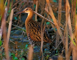
- habitat for several federally listed species at risk including the King Rail, Eastern Whip-poor-will, Least Bittern, Eastern Foxsnake and Swamp Rose-mallow;
- breeding habitat for over 60 species of birds, including waterfowl, waterbirds, landbirds and shorebirds;
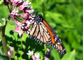
- an important roosting and feeding area for Monarchs during migration.
What are Environment and Climate Change Canada Protected Areas?
Environment and Climate Change Canada establishes marine and terrestrial NWAs for the purposes of conservation, research and interpretation. NWAs are established to protect migratory birds, species at risk, and other wildlife and their habitats. NWAs are established under the authority of the Canada Wildlife Act and are, first and foremost, places for wildlife.

Migratory Bird Sanctuaries (MBSs) are established under the authority of the Migratory Birds Convention Act, 1994, and provide a refuge for migratory birds in marine and terrestrial environments. The current Protected Areas Network consists of 54 NWAs and 92 MBSs comprising more than 12 million hectares across Canada.
What can I do at St. Clair NWA?
Public access is limited to designated areas in the St. Clair Unit, which include a hiking trail and wildlife viewing tower open to the public year-round for day use only. Within the Bear Creek Unit, public access is prohibited, except for water access to Maxwell Creek and Little Bear Creek for recreational boating and fishing (no lead sinkers). Access to other parts of the NWA is restricted; all other activities within the NWA require a permit. For more information on access and permitting, please contact the Canadian Wildlife Service regional office.
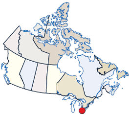
Long description of the map
Location of the NWA on an illustrated map of Canada. The NWA location is indicated by a general annotation in the province of Ontario.
Who can I contact?
Environment and Climate Change Canada - OntarioCanadian Wildlife Service
4905 Dufferin Street
Toronto, Ontario M3H 5T4
1-800-668-6767
Email: ec.enviroinfo.ec@canada.ca
Protected Area web site
