
Gulf of Maine quarterly climate impacts and outlook: June 2014 (experimental)
June 2014 (Experimental)
Gulf of Maine Significant Events - for March-May 2014
Northern Maine and northwestern New Brunswick had their coldest March on record. March 5 was an exceptionally cold day across the region. Edmundston, NB, set a daily record low of -36.2°C (-33°F), and Bathurst, NB, set a daily record low of -33.5°C (-28°F). Caribou, ME, set a daily record low of -28°C (-19°F).
A storm from March 12 to 13 dropped up to 40 mm (1.5 in.) of rain and 52 cm (20 in.) of snow. Caribou set a daily snowfall record on March 13 with 30.2 cm (11.9 in.). The storm caused blizzard conditions on the Acadian Peninsula and a storm surge along the Northumberland Strait.
From March 25 to 26, a powerful Nor'easter affected the region. Snow totals were as high as 53 cm (21 in.), and winds gusted to 113 km/h (70 mph), with a local maximum of 172 km/h (107 mph) in Grand Étang, NS. Blizzard conditions were reported for 11 hours in Moncton, NB, with four hours of zero visibility. Coastal flooding, beach erosion, downed trees, and power outages occurred. The storm leveled the 140-year-old Church Point Lighthouse in St. Mary's Bay, NS. Also in Nova Scotia, the provincial ferry and Halifax bus services were suspended. In addition, a large section of the Trans-Canada highway between Nova Scotia and New Brunswick was closed due to whiteout conditions.
Long description
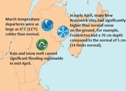
This map shows all provinces and marine areas represented in this report including the United States of Massachusetts, New Hampshire and Maine and the Canadian provinces of New Brunswick, and Nova Scotia. It includes the Atlantic Ocean marine areas bordering these states and provinces. Highlights noted on the map include: March temperature departures were as large as 6°C (11°F) colder than normal across northern New Brunswick and northern Maine. Rain and snow melt caused significant flooding region wide in mid-April. In early April, many New Brunswick sites had significantly higher than normal snow on the ground. For example, Fredericton had a 70 cm depth compared to the normal of 5 cm (14 times normal).
A slow-moving Nor'easter brought ice pellets, freezing rain, snow, strong winds, and whiteouts from March 30 to April 1. Sydney, NS, reported 48 hours of freezing rain. In New Brunswick and northern Nova Scotia, the storm brought down power poles and lines (spans of up to 10 poles came down in NB) and at one point 88,000 customers were affected by power outages in New Brunswick.
Rain and melting snow caused ice jams and flooding in mid-April in New Brunswick and Maine. Hundreds of homes and businesses sustained damage, and dozens of roads were closed. See Regional Impacts section for details.
From April 22 to 25, up to 55 mm (2.2 in.) of precipitation fell in New Brunswick and Maine, causing more flooding.
At the end of April, parts of New Brunswick and Maine had an above-normal snowpack, with up to 50% above normal snow water
equivalent. Due to this, the Saint John River Watch program in New Brunswick was extended a few weeks longer than normal in May.
Severe storms on May 26 produced a weak tornado in Aroostook County, ME, and rotating clouds in New Brunswick. Pea to golf ball sized hail was reported across the region.
Regional Climate Overview - for March-May 2014
Temperature
Departure from Normal: March 1-May 31, 2014
Long description
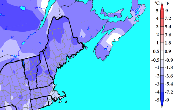
Temperature Departure from Normal map of the Gulf of Maine region (Massachusetts, New Hampshire, Maine, New Brunswick and Nova Scotia) showing the temperature departures from normal in degrees Celsius for March 1 to May 31 2014. The map uses colors ranging from white to shades of darker purple for below normal temperatures and white to shades of dark red for above normal temperatures. This map for the spring indicates that temperature departures ranged from -0.5° to -2°C for most of the region. Northern Maine was colder though, with departures to -3°C and central portions of Nova Scotia were warmer with near normal temperatures.
Spring temperature departures ranged from -0.5° to -2°C (-1° to -4°F) below normal for most of the region. Northern Maine was colder, with departures to -3°C (-5°F). March was a very cold month region-wide, with departures to -6°C (-11°F) below normal. Northwest New Brunswick saw its coldest March on record (since 1913), and Maine and New Hampshire had their 2nd coldest March on record (since 1895). April was colder than normal, but departures were not as large. Temperatures generally ranged from near normal to -1°C (-2°F) below normal, with central Nova Scotia and coastal Massachusetts being the warm exceptions. May departures in the Maritimes ranged from near normal to -3°C (-5°F), but U.S. departures ranged from -0.5° to +1°C (-1° to +2°F). Despite the cold regional temperatures, March was the 4th warmest on record globally, and April tied for record warmest.
Precipitation
Percent of Normal: March 1-May 31, 2014
Long description
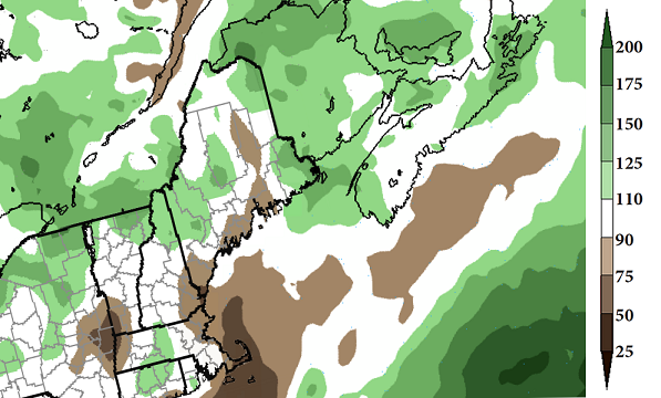
Precipitation Percent of Normal map of the Gulf of Maine region (Massachusetts, New Hampshire, Maine, New Brunswick and Nova Scotia) showing the percent of normal precipitation for March 1 to May 31 2014. The map uses colors ranging from white to shades of darker brown for below normal precipitation and white to shades of dark green for above normal precipitation. This map for the spring indicates that precipitation departures generally ranged from 90-150% of normal with the higher amounts across northern New Brunswick and eastern Nova Scotia. US coastal areas were drier with only 50-90% of normal.
During spring, precipitation generally ranged from 90-150% of normal. However, U.S. coastal areas saw only 50-90% of normal. For March, much of the region received 90-175% of normal; however, portions of southern Nova Scotia and the U.S. coast were notably drier. In April, the Canadian provinces saw departures of 90-175% of normal, with southern New Brunswick and northern Cape Breton slightly drier. The U.S. received 50-90% of normal, except eastern Maine, which was wetter. Most of the Maritimes were quite dry in May, seeing 25-75% of normal. Northern New Brunswick, however, had up to 125% of normal. In the U.S., May precipitation ranged from 50-110% of normal in coastal areas to 90-200% inland.
Temperature and precipitation normals based on 1981-2010. Canada and ocean precip data: Canadian Precipitation Analysis. U.S. precip data: interpolated station data.
Sea Surface Temperatures
Departure from Normal: March 1-May 31, 2014
Long description
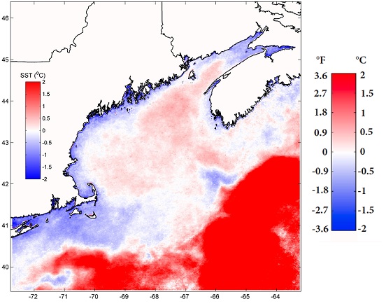
Sea Surface Temperature Departure from Normal map of the Gulf of Maine region (Massachusetts, New Hampshire, Maine, New Brunswick and Nova Scotia and adjacent ocean area) showing the departure from normal of sea temperature for March 1 to May 31 2014. The map uses colors ranging from white to shades of darker blue for below normal temperature and white to shades of dark red for above normal temperature. This map for the spring indicates that sea surface temperature departures across the region were divided. Deeper areas such as the Wilkinson and Jordan Basins, deeper parts of the Bay of Fundy, and especially the Gulf Stream offshore continued to experience warm anomalies. Temperature departures in these areas ranged from +0.5°C to greater than +1.5°C. However, shallow coastal regions experienced cold anomalies, with departures from -0.5°C to -1°C. Northeastern portions of the Scotian Shelf were also slightly below average.
Sea surface temperature anomalies across the region varied. Deeper areas such as the Wilkinson and Jordan Basins, deeper parts of the Bay of Fundy, and especially the Gulf Stream offshore continued to experience warm anomalies. Departures in these areas ranged from +0.5°C (+0.9°F) to greater than +1.5°C (+2.7°F). Although weaker, these warm anomalies have persisted all winter and since 2013. However, shallow coastal regions experienced cold anomalies, with departures from -0.5°C (-0.9°F) to -1°C (-1.8°F). Northeastern portions of the Scotian Shelf were also slightly below average.
Sea surface temperature anomalies based on 1985-2014. Mean SST anomalies from NOAA AVHRR data. Credit: University of Maine School of Marine Sciences and NERACOOS
Regional Impacts - for March-May 2014
Recreation
The harsh winter took a toll on area golf courses. The already short golf season started late, meaning thousands of dollars in lost income. In addition, multiple freezes and thaws led to ice damage on greens and costly repairs. Maine State Golf Association's opening tournament at Biddeford-Saco Country Club in mid-April was canceled, making it the first time the tournament could not be played at the site.
Flooding

The 87-year-old Cherryvale Bridge was washed away by flood waters in mid-April. Credit: New Brunswick Department of Transportation and Infrastructure
Rain, warm temperatures, and quick melting of a larger-than-normal snowpack caused flooding in mid-April in the Maritimes and Maine. Preliminary data indicated that several rivers had record or near-record crests. The flooding caused significant damage to roads, bridges, and other infrastructure. In Maine, a five-mile long ice jam flooded the only road to Allagash and St. Francis, stranding residents. In Cape Breton, NS, a mudslide reduced travel on the Cabot Trail. In New Brunswick, about 70% of the village of Sussex Corner was under water and the Cherryvale covered bridge, which had been in place for 87 years, was swept downstream. Flood damage in New Brunswick was estimated to exceed $14 million (Canadian dollars). The provincial government approved a Disaster Financial Assistance program that will help pay for "uninsurable damages and losses that threaten health and safety."
Fisheries
While recent sea surface temperatures have been cooler, 2013 temperatures were the second warmest since 1982. In fact, from 2004 to 2013, temperatures in the Gulf of Maine increased faster than 99.9% of the global ocean. The ecosystem responded to these unusual conditions in unexpected ways. The spring 2013 phytoplankton bloom was among the smallest in the satellite record (since 1998), and this may have impacted the zooplankton community. The phytoplankton community recovered and was back to historical conditions in the fall. One of the notable trends in the oceanographic conditions in the Gulf of Maine is a later appearance of fall-like temperatures.
Agriculture
In March, maple season was weeks behind schedule. Cold temperatures prevented sap from running to taps, while deep snow made some taps inaccessible. Growers were also behind. In mid-May, blueberry producers in the Maritimes reported low winter injury, but fruit buds were 5 to 7 days behind average. Potatoes, corn, and apples were also reported to be behind schedule. Conditions improved in late May, and farmers were optimistic for a productive season.

Long description
This Environment Canada seasonal forecast map shows the probability of below and above normal temperatures in the Gulf of Maine region for summer 2014. The yellow area shown across Nova Scotia and its adjacent marine areas depicts a 40-50% chance of higher than normal temperatures for the June to August period with equal chances elsewhere.

Long description
This NOAA seasonal forecast map shows the probability of below and above normal temperatures in the Gulf of Maine region for summer 2014. The light and dark orange areas shown across all of Maine, New Hampshire and adjacent marine areas depicts a 33-50% chance of higher than normal temperatures for the June to August period.
Regional Outlook - for Summer 2014
Temperature
For June-August, Environment Canada is calling for an increased chance of above-normal temperatures for Nova Scotia and equal chances elsewhere (graphic above). NOAA's Climate Prediction Center is forecasting an increased chance of above-normal temperatures for Maine, New Hampshire, and Massachusetts from June to August (graphic below).
Precipitation
Environment Canada and NOAA's Climate Prediction Center are both predicting equal chances of above-, near-, or below-normal precipitation for June-August.
El Niño
While El Niño Southern Oscillation conditions remain neutral, sea surface temperatures in the equatorial Pacific Ocean were above-average. In early June, NOAA indicated chances for El Niño development were 70% during summer and 80% during fall and winter.
Atlantic Hurricane Season
NOAA is predicting a 50% chance of a below normal 2014 Atlantic hurricane season, a 40% chance of a near-normal season, and a 10% chance of an above-normal season. The outlook calls for a 70% chance of each: 8-13 named storms, 3-6 hurricanes, and 1-2 major hurricanes. While El Niño was the main driver of the outlook, it also took into account the predicted near- to below-normal sea surface temperatures and current conditions in the Atlantic hurricane main development region. El Niño enhances wind shear and can increase atmospheric stability. These conditions hinder hurricane development and strength.
Red Tide
In mid-May, the Woods Hole Oceanographic Institution in Massachusetts predicted a moderate harmful algal bloom called red tide for the Gulf of Maine during 2014. Red tide can adversely affect the health of humans and marine ecosystems as well as local and regional economies. By early June, high levels of the red tide toxin were detected in the western Gulf, leading Maine, Massachusetts, and New Hampshire to close several shellfish beds.
Gulf of Maine Region Partners
Northeast Regional Climate Center
National Oceanic and Atmospheric Administration
National Operational Hydrologic Remote Sensing Center
Northeast River Forecast Center
Gulf of Maine Research Institute
National Integrated Drought Information System
Cooperative Institute for the North Atlantic Region
Gulf of Maine Council on the Marine Environment, Climate
Network
Northeastern Regional Association of Coastal and Ocean
Systems
Contacts
NOAA:
Ellen Mecray
Samantha Borisoff
Environment Canada:
1-800-668-6767 (in Canada only)
819-997-2800 (long-distance charges apply)
enviroinfo@ec.gc.ca
This is a new publication designed to help others understand climate trends and their impacts. We welcome your feedback.