
All Domain Situational Awareness Science and Technology Program
Video / December 7, 2020
Transcript
The All Domain Situational Awareness science and technology program is making long-term investments to provide a greater awareness of safety and security issues, transportation and commercial activity in Canada’s Arctic. Solutions achieved under the program support the Government of Canada’s ability to exercise sovereignty in the North–that means, knowing who is travelling to, and through, the Canadian Arctic and its approaches at all times.
Canada’s Defence Policy, Strong, Secure, Engaged, committed to renewing the existing North Warning System as part of NORAD Modernization. The collaborative projects spawned by the ADSA program are leading the way for this change which is an essential component of our commitment to defending the continent.
Scientists from Defence Research and Development Canada are designing, building, and demonstrating an adapted version of a newer, more advanced form of “Over-the-Horizon Radar”– able to detect potential threats thousands of kilometers away by bouncing radar waves off the ionosphere.
An underwater network of sensors to detect sounds and vibrations of maritime traffic is also being explored. Defence scientists are characterizing the changing Arctic underwater environment to calibrate these systems. Scientists at DRDC are developing prototypes that will influence and inform the development of maritime surveillance in the future.
The ADSA program is also exploring the novel application of quantum information science to create next generation specialized radars to help defend Canada’s North.
Context-aware sensor systems have also been designed to gather information about different environments and adapt to these environments in real-time. This is proactively addressing newer threats in the Canadian Arctic, allowing the Canadian Armed Forces to remain agile in an ever-changing security landscape.
The development of space-based earth observation and intelligence capabilities integrates multipurpose microsatellites, enhancing how the Forces quickly detect ships and aircraft approaching the Arctic.
Innovations such as these will become the eyes and ears of Canada’s North, keeping a careful watch over those travelling above and below Canadian Arctic waters.
In partnership with Industry, Academia, and allies, Defence Research and Development Canada continues to innovate and update security infrastructure keeping Canada and the Canadian Armed Forces strong, secure and engaged.
Viability
Canada’s defence policy, Strong, Secure, Engaged, places Arctic joint intelligence, surveillance, and reconnaissance as defence research and development priorities.
The All Domain Situational Awareness (ADSA) Science and Technology (S&T) Program is investing $133 million from 2015 to 2020 to support the development of innovative solutions to address surveillance challenges in the North.
Surveillance solutions achieved under the ADSA S&T Program support the Government of Canada’s ability to exercise sovereignty in the North, and will provide a greater awareness of safety and security issues, and of transportation and commercial activity in Canada’s Arctic. They will also contribute to joint efforts between Canada and the United States to modernize elements of the North American Aerospace Defense (NORAD) Command.
Projects
Canada and the United States are working together to find innovative technological solutions to continental defence challenges. The ADSA S&T Program is part of this collaboration.
A number of projects have received funding via the ADSA S&T Program including:
Over-the-Horizon Radar (OTHR) Project
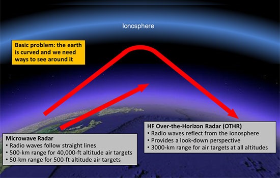
Description
Image depicting earth’s curvature and how OTHR radio waves reflect from the ionosphere to see beyond the horizon.
Ionosphere
Basic problem: the earth is curved and we need ways to see around it.
Mircowave Radar
- Radio waves follow straight lines
- 500-km range for 40,000-ft altitude air targets
- 50-km range for 500-ft altitude are tadrgets
HF Over-the-Horizon Radar (OTHR)
- Radio waves reflect from the ionosphere
- Provides a look-down perspective
- 3000-km range for air targets at all altitudes
The purpose of OTHR systems is to detect out-of-sight targets far beyond the horizon, unlike traditional radar which is limited to much closer line-of-sight objects. The bouncing of radar waves off the upper atmosphere allows OTHR to achieve a much longer range for target detection.
OTHR systems are currently operational worldwide; however, in the northern regions signals passing through and reflected from the Aurora Borealis can diminish their performance. This project was launched to study possible ways to improve the performance when the Aurora Borealis is present.
The following contracts were awarded for the project:
| Project Title | Supplier |
|---|---|
| Development of the Canadian High Arctic Ionospheric Models (CHAIM) | University of New Brunswick |
| Polar Over-the-Horizon Radar – Transmit Site | Raytheon Canada Ltd |
| Polar Over-the-Horizon Radar – Receive Site, Raytheon Canada Ltd | Raytheon Canada Ltd |
Canadian Arctic Underwater Sentinel Experimentation (CAUSE) Project
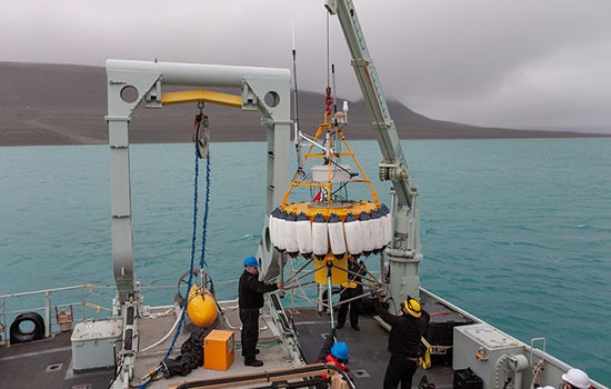
Description
Image depicting an underwater/under-ice surveillance technology.
Situational awareness in all domains, including the underwater environment, is essential to assert Canada’s sovereignty in the Arctic, and to support the Canadian Armed Forces’ mission to defend our Nation.
The CAUSE Project develops and tests various surveillance systems for underwater and under-ice surveillance throughout the Arctic. The project enhances the Canadian Armed Forces' capabilities and readiness to conduct operations in a changing Arctic environment.
The following contracts were awarded for the project:
| Project Title | Supplier |
|---|---|
| Acoustic Source for Ocean Propagation Experimentation | GeoSpectrum Technologies Inc |
| Acoustic Array for Persistent Under-Ice Vehicles | GeoSpectrum Technologies Inc |
| Unmanned Underwater Vehicle (UUV): Fuel Cell and Suction Anchor | Cellula Robotics Ltd |
Threat, Requirement and Gap (TRG) Analysis Project
The TRG Analysis Project assesses threats to three physical domains in Canada’s North: air, maritime surface, and maritime sub-surface. The project then analyzes the gaps in Arctic intelligence, surveillance and reconnaissance capabilities and develops technology options and concepts that will assist the Canadian Armed Forces in better operating in the changing Arctic environment. It also examines surveillance requirements and compares possible technological solutions.
The following contracts were awarded for the project:
| Project Title | Supplier |
|---|---|
| All Domain Sensor Mix Evaluation Tool (ADSMET) | MDA |
| Context-aware sensor selection layered architecture for Arctic surveillance | Complex Systems Inc |
Compression of the Tasking, Collection, Processing, Exploitation and Dissemination (TCPED) Cycle Project
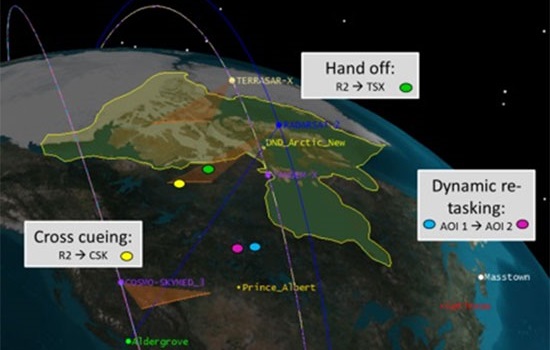
Description
Image depicting satellite functions over the earth.
Hand off:
R2 —> TSX
Cross cueing:
R2 —> CSK
Dynamic re-tasking:
AOI 1 —> AOI 2
In 2016, an initiative was launched, through a series of contracts, to improve the TCPED cycle for future Canadian earth observation satellites.
The contracts are modeled on the Defence Innovation Research Program (DIRP) structure and are funded 50/50 between government and industry.
These cutting-edge projects offer innovative ideas on how to best maintain, enhance and modernize the Canadian Armed Forces’ capabilities to observe the earth using satellites. They will ensure an accurate, timely and uninterrupted picture of Canada's territory, including its air and maritime regions. They will also contribute to joint efforts between Canada and the United States to improve surveillance capabilities in support of Canadian and NORAD requirements and missions.
First Round of Project Submissions
The first DIRP call for submissions in 2016 resulted in 11 projects from eight suppliers receiving close to $7.7 million from the Government of Canada, for a total investment of almost $15.4 million.
The following contracts were awarded under the first TCPED call for submissions:
| Project Title | Supplier |
|---|---|
| Real time TCPED cycle for RADARSAT Constellation Mission Follow-On | Airbus |
| Multi-aperture synthetic aperture radar (SAR) tools | C-CORE |
| Electromagnetic monitoring and analysis (EMMA) 2.0 | Com Dev |
| Constellation mission planning system | Globvision |
| Sensor tasking and data collection management using high-level information fusion for improved system-of-systems operation | Larus |
| Tactical on-board processing innovation | MDA |
| A system of systems approach to improving TCPED | MDA |
| Fusion of open data sources with automated identification system (AIS) and Earth observation data for enhanced marine domain awareness (MDA) | OODA |
| Multi aperture multi-frequency digital SAR | UrtheCast Corp. |
| Real-time on board automated tasking | UrtheCast Corp. |
| On-board processing of SAR data | UrtheCast Corp. |
Second Round of Project Submissions
The second DIRP call for submissions in 2017 resulted in 12 projects from nine suppliers receiving close to $6.7 million from the Government of Canada, for a total investment of almost $13.4 million.
The following contracts were awarded under the second TCPED call for submissions:
| Project Title | Supplier |
|---|---|
| Complementary Electro-Optic/Infrared (EO/IR) payload to RADARSAT Constellation Mission | ABB |
| Project Arviq | AstroCom Associates Inc. |
| Multi-satellite data integration for operational ship detection, identification and tracking | C-CORE |
| Modelling the geospatial intelligence capability to support Canadian surveillance and sovereignty | C-CORE |
| Electro-Optic/Infrared data analytics for enhanced maritime surveillance | Complex System Inc. |
| RADARSAT thematic exploitation platform demonstrator | CubeWerx Inc. |
| Real-time processing of large-volume space-based multimodal data | General Dynamics Mission Systems |
| Augmenting Canada’s maritime surveillance capability with complementary electro-optic/infrared information products | MDA Systems Ltd |
| Persistent multi-sensor land surveillance and change monitoring | MDA Systems Ltd |
| Application of Big Data analytics techniques to extracting geospatial intelligence (GEOINT) from SAR imagery | MDA Geospatial Services Inc. |
| Architecture innovations for analytics-ready data | UrtheCast Corp. |
| Complementary sensor exploitation | UrtheCast Corp. |
Announcements
2018
- Government of Canada announces contract awards aimed at improving space-based earth observation capabilities
- Government of Canada announces contract award to the University of Waterloo for research and development in support of Arctic surveillance
- Government of Canada announces contract award to Cellula Robotics Ltd for research and development in support of sub-surface surveillance in Arctic
Page details
- Date modified: