
Transmit site and preliminary receive site for the Arctic Over-the-Horizon Radar Program in Southern Ontario
From: Department of National Defence (DND)
The Department of National Defence (DND) is implementing the Arctic Over-the-Horizon Radar (A-OTHR) program in southern Ontario, part of a key NORAD modernization initiative. We aim to ensure our defence capabilities are relevant and inclusive for all Canadians, with input from Indigenous, intergovernmental, and community partners. DND is committed to maintaining strong relationships with local communities as we implement these NORAD modernization efforts.
Public participation
From July 17, 2025 to October 15, 2025, the Department of National Defence conducted public consultations on Stage 1 of A-OTHR Program by means of an online feedback form. Over 400 forms were received, indicating a high level of interest from both local communities and individuals across Canada.
On September 9 and 10, 2025 the Department of National Defence hosted public engagement sessions to answer questions and provide details about the upcoming construction of the Arctic Over-The-Horizon Transmit Site at 0 Thistle Trail, Kawartha Lakes and the preliminary Arctic Over-The-Horizon Receive Site at 2225 Sideroad 15 and 16, Clearview Township.
A What We Heard report summarizing public feedback received online, at the public engagement sessions, and via direct correspondence is available here:
- What We Heard
- Annex A - City of Kawartha Lakes Town Hall Presentation
- Annex B - City of Kawartha Lakes Town Hall Q&A Summary 2:00 p.m. EST 9 September 2025
- Annex C - City of Kawartha Lakes Town Hall Q&A Summary 7:00 p.m. EST 9 September 2025
- Annex D - Clearview Township Town Hall Presentation
- Annex E - Clearview Town Hall Q&A Summary 2:00 p.m. EST 10 September 2025
- Annex F - Clearview Town Hall Q&A Summary 7:00 p.m. EST 10 September 2025
This feedback will inform A-OTHR program planning and decision-making. We are committed to ensuring that public input plays a meaningful role in shaping the outcomes of this initiative. To receive notifications of the latest A-OTHR updates, subscribe to an email distribution list by visiting the link below:
Additional information DND committed to providing during the public engagement sessions has been added to the Health and safety section, in the Ground level and Aircraft altitudes subsections at the bottom of this page.
Arctic Over-the-Horizon Radar Frequently Asked Questions
Q1. When will a siting decision be made on the locations of permanent radar sites for future stages of the program?
A.1 We continue to assess siting options for the remaining permanent transmit and receive sites for the installation of the full Arctic Over-the-Horizon (A-OTHR) capability.
Until a final siting decision is made, we encourage neighbouring residents to continue with normal activities – farming, running businesses, and making property improvements. Farming operations should proceed as planned in 2026 and beyond.
Q2. What size of land (area) is needed for future stages of the Arctic Over-the-Horizon program?
A.2 The transmit site and preliminary receive site for the first stage of the A-OTHR program have been identified. The Department of National Defence (DND) continues to assess siting options for the remaining transmit and permanent receive sites for the installation of the full Arctic Over-the-Horizon Radar capability. The remaining sites combined will total approximately 1500 hectares and will be located south of the 46th parallel north. As a frame of reference, this latitude roughly aligns with the Trans-Canada Highway within the province of Ontario.
Q3: Why does the A-OTHR need to be located in Southern Ontario?
A.3 Arctic Over-the-Horizon Radar uses the ionosphere to bounce signals beyond the horizon, allowing it to detect objects thousands of kilometers away. (see figure 1)
For the system to work well, the signal’s bounce point must stay outside the auroral zone, where the Northern Lights interfere with radar performance.
The optimal latitude for achieving full coverage of Canada’s northern approaches, and especially the critical northeast corridor, runs through Southern Ontario. This location allows for maximum range and reliability.
Q4. Why are you focused on agricultural land?
A.4 The Department of National Defence’s siting analysis for Arctic Over-the-Horizon Radar is driven by a set of complex and inflexible requirements. These include parcel size, latitude, orientation, distance separation between parcels, environmental conditions and constraints, and adjacent land use.
Potential sites must:
- Be in a remote, flat, and dry area
- Have limited environmental constraints
- Be a suitable distance from radio noise sources
- Be close to electrical power sources
Q5. Why not locate Stage 1 of the Arctic Over-the-Horizon Radar program at Canadian Forces Base (CFB) Borden or Meaford?
A.5 The Department of National Defence (DND) began its site selection process by reviewing existing DND properties, followed by other federal lands, before considering private parcels. Hundreds of potential sites were analyzed against stringent technical criteria, including parcel size, topography, spacing requirements, and radio-frequency environment to ensure optimal radar performance.
CFB Borden and the 4th Canadian Division Training Centre in Meaford, Ontario, present environmental and topographical constraints, and are currently busy training establishments responsible for preparing thousands of military personnel annually across a wide range of disciplines. These factors would significantly challenge meeting Stage 1 program requirements within the required capability timelines.
Q6. Should residents be concerned about health and safety issues related to the radar system?
A.6 The A-OTHR Program will implement rigorous health and safety-related programs to comply with federal legislation, regulations and safety codes. These programs will ensure appropriate levels of performance of the system, including management of the radiation hazard zone from personnel and public safety perspectives, implement and manage an auditable hazard management system, demonstrate that risks to health and safety have been eliminated so far as reasonably practicable, and monitor and maintain security compliance across the A-OTHR system.
There are no federal standards concerning exposure of Radio Frequency (RF) radiation to all Canadians. However, Health Canada's Safety Code 6 provides instruction and guidance for all public service departments, agencies and those coming under the jurisdiction of the Canada Labour Code. Safety Code 6 applies to RF devices operating in the frequency range from 3 kHz to 300 GHz.
Understanding Safety Code 6: Health Canada's radiofrequency exposure guidelines
The A-OTHR system will be enclosed with a minimum of three types of fences:
- perimeter fencing, used for security and access control
- public radiation hazard fencing (transmit site only), to provide a physical barrier displaying signage and preventing entry within the radiation hazard zone by livestock, wildlife and the public
- occupational radiation hazard fencing (transmit site only), to control entry within the radiation hazard zone by operators and maintenance personnel
There are no known adverse human health effects associated with the receive sites. The radio emissions that arrive at the receive sites, after traveling down range from the transmit site and echoing back, will be very faint.
For further context, “very faint” means at least 1,000,000,000,000,000 (one quadrillion) times less powerful than the safe limit established by Health Canada’s Safety Code 6, and at least 1,000,000,000,000 (one trillion) times less powerful than typical long-term evolution (LTE) cellular phone emissions (noting that cellular phone emissions are in a different frequency band).
At ground level for the transmit sites, hazardous radiation zones will be contained within the perimeter of the fences and away from human exposure. There are no known adverse human health effects associated with this type of technology at distances beyond the perimeter fence.
Q7. There are concerns that the facility will become a target in the event of a military conflict. What security measures will be utilized to ensure the safety of the facility and the people who live nearby?
A.7 While DND/CAF does not disclose specific security measures, we want to reiterate that we are committed to ensuring the public’s ongoing safety and that public input plays a meaningful role in shaping the outcomes of this initiative.
In an era of growing global instability and rapidly evolving threats, Canada’s Arctic Over-the-Horizon Radar system will serve as Canada’s eyes deep into the North, delivering early warning and enhanced defence against modern threats.
Q8. Will there be environmental impacts from this program?
A.8 As per our standard procedure, the Department of National Defence will conduct several environmental and site studies on all sites before beginning work, including:
- a climate change risk assessment to determine potential impacts to the site;
- a life cycle carbon assessments for the proposed buildings;
- an environmental site assessment to determine whether the sites contain any existing soil and groundwater contamination;
- an assessment of the watercourse and wetlands within or in proximity to the area that may be impacted by the program;
- a flora and fauna assessment to determine a baseline that includes migratory birds, at risk wildlife (legislated both federally and provincially), and identification of habitat types in the area and surroundings; and
- the historical and archeological potential of the area to contain valuable artifacts, structures, and Indigenous utilization.
Upon completion of these studies, an environmental effects determination will be undertaken in accordance with the Impact Assessment Act to support the program’s ongoing design and specifications. This determination identifies potential adverse environmental impacts and mitigation measures to be implemented to minimize the potential adverse effects. It is important to note that:
- any impacts to water bodies may require authorization from the Fisheries and Oceans Canada;
- any alteration to wetlands will require mitigation and compensation under the Federal Policy on Wetland Conservation;
- the application of the Migratory Bird Convention Act and its regulations may influence timelines (i.e. work must be completed outside of the migratory bird window); and
- the Species at Risk Act applies to federal land and Species at Risk permits may be required.
Q9. Is DND looking at creating a “no-fly zone” over the area of the Over the Horizon radar receive site in Clearview Township, which would include the Collingwood Airport?
A.9 The proposed A-OTHR installations in Clearview Township will not interfere with or negatively affect local air traffic, including operations at the Collingwood Airport. These sites do not produce noise or radiation that could pose any risk to aircraft or the surrounding community.
As with most Department of National Defence (DND) properties across Canada, standard restrictions will be applied to protect the security of operations at DND facilities. In terms of airspace, these restrictions focus specifically on the use of drones or other unmanned aerial vehicles in and around these sites.
Q10. Residents say that a DND official told them that expropriation could be used to acquire the land. Is this true?
A.10 While DND is exploring land acquisition strategies to support A-OTHR needs, DND is not currently working on expropriation of land plans.
Q11. What is your timeline to acquire the needed land?
A.11 The Department of National Defence (DND) is developing the timeline for buying land for future stages of this program because site selection is ongoing and will play an important role in setting that schedule. Land needed for the approved sites has already been secured. As more land is needed to enable future stages of the capability, DND will follow a fair and respectful process. The goal is to work collaboratively with landowners, and provide clear communication and fair compensation.
Q12. Residents say they were told that DND would need the land for only 30 years. Is this accurate? How long do you need this land?
A.12 The site acquired in Clearview as part of Stage 1 is a preliminary receive site and will be used until a permanent location for the full capability is established. A-OTHR is being designed as an enduring capability, which means the land will be needed for as long as this system remains relevant to Canada’s defence.
There is no fixed timeline, but regular evaluations will determine whether the system and the land continue to be required. These assessments will be shared with the public as they become available, to inform the community throughout the life of the project.
Q13. Will A-OTHR interfere with communications or amateur radio signals?
A.13 The A-OTHR is anticipated to operate in the high frequency range, between 4 and 30 MHz. There is no anticipated interference with communications signals, such as cellular, satellite, or broadcast radio and television.
The A-OTHR will not operate in the amateur radio bands in the high frequency range. There is potential risk, however, of the A-OTHR transmitter overloading nearby amateur radio receiver front ends when the A-OTHR transmitter is operating in non-amateur radio bands within the high frequency range. Similarly, there is potential risk of nearby amateur radio transmitters overloading the A-OTHR receiver front ends when the A-OTHR receiver is operating in non-amateur radio bands within the high frequency range. DND will continue to engage with amateur radio organisations to mitigate these risks.
The A-OTHR System infrastructure will be designed and constructed to meet shielding, earthing and lightning protection requirements.
Q14. How do we know that A-OTHR will not become obsolete before completion?
A.14 DND is continuously evaluating alternatives. Given the target set, ranges, and persistence A-OTHR provides, emerging alternatives are not expected to replace it within the project’s time horizon.
Space-based systems are being explored but cannot yet match A-OTHR’s coverage, persistence, and ability to track certain targets. A layered defense approach is planned.
About the Arctic Over-the-Horizon Radar (A-OTHR) program
In June 2022, the Minister of National Defence announced Canada's plan to modernize our contribution to NORAD with a total funding of $38.6 billion over 20 years. NORAD modernization is an important step in addressing Canada's renewed requirements to strengthen the all-domain defence of Canada and North America.
As part of Canada's NORAD modernization plan, DND is investing in a new Northern Approaches Surveillance System (NASS) to significantly expand NORAD and the Canadian Armed Forces' (CAF) situational awareness of objects approaching and entering Canadian airspace from the North. NASS will include the A-OTHR system that will provide early warning radar coverage and threat tracking.
Locations in Southern Ontario
The A-OTHR capability will be in Southern Ontario and will extend NORAD and the CAF's situational awareness into the Canadian North and the North Atlantic.
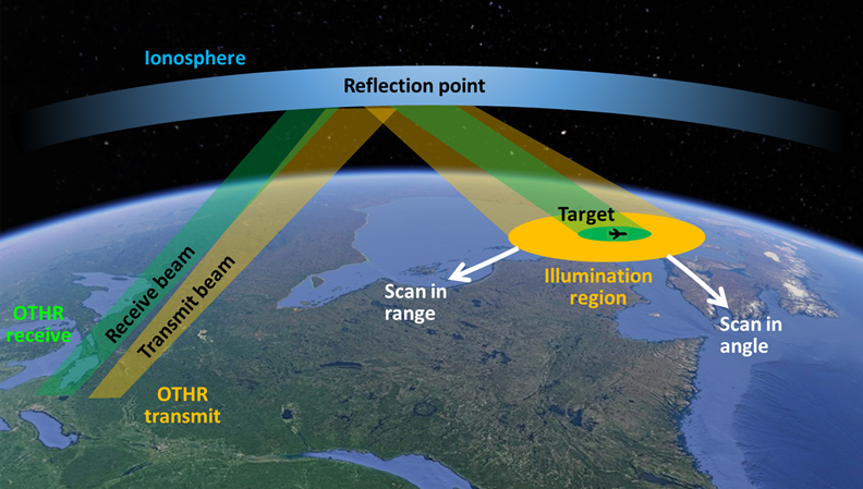
Over-the-Horizon Radar can conduct surveillance at far greater ranges than regular radar technology as it bounces radar beams off the ionosphere to see around the curvature of the Earth (see figure 1 below).
The A-OTHR system needs to be in Southern Ontario to meet NORAD surveillance requirements.
Figure 1: A-OTHR Feedback Form Submissions per day
Caption
Illustration of the process through which the Arctic Over-the-Horizon Radar (A-OTHR) reflects radio waves to observe targets up to 3000 km away. The transmit beam travels from Earth, reflects off the ionosphere, and reaches a target area within the 'Illumination region.' The receive beam returns from the target via the ionosphere. The ionosphere is a curved layer above Earth.
Up to four permanent sites will be required for the system's final two transmit and two receive locations. DND is currently assessing possible siting locations in Southern Ontario.
The sites will be parcels of land ranging in size from a minimum of 100 hectares to 1200 hectares and will be located south of the 46th parallel north (as a frame of reference, this latitude roughly aligns with the Trans-Canada Highway) within the provincial border of Ontario.
Two Sites identified for Stage 1
DND purchased two sites in Southern Ontario:
- Kawartha Lakes site: to be used as a full, permanent transmit site
- Clearview Township site: to be used as a preliminary receive site
A-OTHR will be implemented in a staged approach, with Stage 1 setting the foundation for further development and expansion of the system.
In July 2023, before purchasing the two sites, Public Services and Procurement Canada (PSPC) posted notices on Canada Buys and in community newspapers to advise property owners that DND was interested in buying land in Southern Ontario. They were given a deadline of August 31, 2023 to confirm their interest. DND also contacted private landowners, Indigenous communities, other federal government departments, and the Province of Ontario to assess siting opportunities. The options proposed during these discussions were found to be unsuitable for the A-OTHR Program. DND proceeded with the purchase of the Kawartha Lakes and Clearview Township sites, privately owned land parcels listed on the open market.
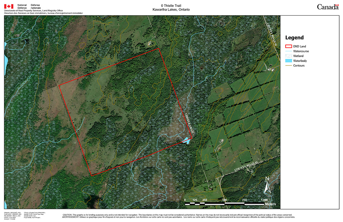
Kawartha Lakes: Transmit Site at 0 Thistle Trail
A map of the A-OTHR transmit site at Thistle Trail can be found below (figure 2).
Site details:
- 163-hectare of vacant property comprised of a mix of pastureland, forest, and marsh lands.
- At the time of acquisition, the lands were actively used for cattle grazing.
- Observed wildlife includes various mammal, bird, reptile, and amphibian species, including federally and provincially listed Species at Risk.
- Surrounding lands consist of rural residential and agricultural uses.
- Development on nearby lands must be compatible with radar operations. This may restrict how surrounding land is used in the future.
Figure 2: Site map of Thistle Trail site
Caption
An aerial view outlining the site located at 0 Thistle Trail, in Kawartha Lakes, Ontario. It is accessed and bordered on the east by Thistle Trail. Nearest major roadway is County Road 41, running North-South to the East of the site. There are rural residential and agricultural lands surrounding the site.
Clearview Township: Preliminary Receive Site at 2225 Sideroad 15 and 16
A map of the preliminary A-OTHR receive site in Clearview Township can be found below (figure 3).
Site details:
- 288-hectare of agricultural land with some farm structures on the west side of the site.
- At the time of acquisition, the lands were actively used for growing and harvesting crops.
- The property consists of some wooded areas on the east side and is bisected by a creek.
- The site overlaps with provincial Areas of Natural and Scientific Interest (ANSI).
- The site falls within the “regulated area” of the Nottawasaga Valley Conservation Authority (NVCA).
- Surrounding land consists predominately of agricultural lands with limited recreational and commercial uses.
Figure 3: Site map of Clearview Township site
![]()
Caption
An aerial view outlining the site located at 2225 15th and 16th Sideroad, in Clearview Township, Ontario. The site runs adjacent to a road running east-west on the north side called Sunnidale Concession 7 and Sunnidale Concession 6 on the south side. South Sunnidale Sideroad 15 & 16 runs north-south adjacent to the site. There are agricultural land and wetlands surrounding the site.
Ongoing Siting Analysis
DND's siting analysis for A-OTHR is driven by a set of complex and inflexible requirements. These include parcel size, latitude, orientation, distance separation between parcels, environmental conditions and constraints, and adjacent land use.
Potential sites must:
- be located in a remote, flat and dry area
- have limited environmental conditions and constraints
- be a suitable distance from radio noise sources
- be close to electrical power sources
For these reasons, suitable permanent sites for A-OTHR are relatively limited and our analysis continues. We look forward to sharing additional siting information when it becomes available.
What the A-OTHR will look like
The A-OTHR sites located in Southern Ontario will consist of four antenna sites (two transmit and two receive sites) and supporting infrastructure. The program is expected to be accommodated on lands acquired for this program and existing DND sites.
Land preparation will be required for each location, including flattening of the land and removal of any obstructions that would impede the radar's signal, including potential clearing of forested areas or filling of wetlands.
Receive site (6m tall)
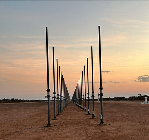
Caption
Two parallel rows of metallic posts anchored in the ground.
Transmit site (up to 45m tall)
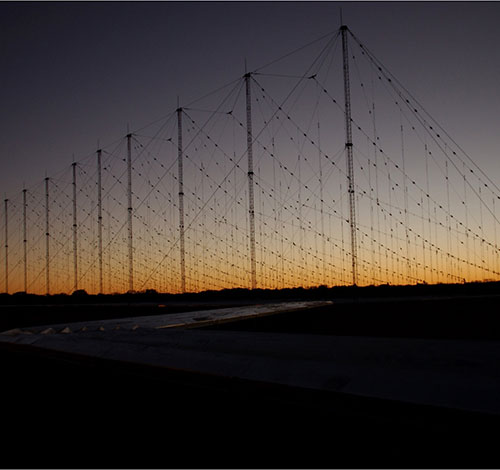
Caption
An antenna array featuring multiple rows of metallic poles of varying height anchored in the ground, tethered by wires.
Note: the Canadian A-OTHR capability will be modified to meet Canada's environment and operational needs (e.g. different number of antennas, etc.)
Program timeline
Initial work is anticipated to begin at the Kawartha Lakes and Clearview Township sites as early as winter 2026, with the initial Stage 1 capability to be installed by the end of 2029.
Regarding future stages of the program, DND is committed to sharing detailed information as it becomes available. The full A-OTHR capability is anticipated by 2043.
Environmental impacts
DND will conduct several environmental and site studies at both sites, including:
- an environmental site assessment to determine whether the sites contain any existing soil and groundwater contamination
- an assessment of the watercourse and wetlands within or in proximity to the program area that may be impacted by the program
- a flora and fauna assessment to determine a baseline that includes migratory birds, at risk wildlife (legislated both federally and provincially), and identification of habitat types in the program area and surroundings
- an archaeological assessment of the areas
Once these studies are done, an environmental effects determination will be completed under the Impact Assessment Act (IAA) to support the program's ongoing design and specifications. This determination identifies potential adverse environmental impacts and identifies mitigation measures to be implemented to minimize the potential adverse effects.
Health and safety
The A-OTHR Program will implement rigorous health and safety-related programs to comply with federal legislation, regulations and safety codes. These programs will ensure appropriate levels of performance of the system, including management of the radiation hazard zone from personnel and public safety perspectives, implement and manage an auditable hazard management system, demonstrate that risks to health and safety have been eliminated so far as reasonably practicable, and monitor and maintain security compliance across the A-OTHR system.
There are no federal standards concerning exposure of Radio Frequency (RF) radiation to all Canadians. However, Health Canada's Safety Code 6 provides instruction and guidance for all public service departments, agencies and those coming under the jurisdiction of the Canada Labour Code. Safety Code 6 applies to RF devices operating in the frequency range from 3 kHz to 300 GHz.
Understanding Safety Code 6: Health Canada's radiofrequency exposure guidelines
The A-OTHR system will be enclosed with a minimum of three types of fence:
- perimeter fencing, used for security and access control
- public radiation hazard fencing (transmit site only), to provide a physical barrier displaying signage and preventing entry within the radiation hazard zone by livestock, wildlife and the public
- occupational radiation hazard fencing (transmit site only), to control entry within the radiation hazard zone by operators and maintenance personnel
There are no known adverse human health effects associated with the receive sites. The radio emissions that travel down range from the transmit site and echo back to the receive site in Clearview will be very faint.
For further context, “very faint” means at least 1,000,000,000,000,000 (one quadrillion) times less powerful than the safe limit established by Health Canada’s Safety Code 6, and at least 1,000,000,000,000 (one trillion) times less powerful than typical long-term evolution (LTE) cellular phone emissions (noting that cellular phone emissions are in a different frequency band).
Ground level
At ground level for the transmit sites, hazardous radiation zones will be contained within the perimeter of the fences and away from human exposure. There are no known adverse human health effects associated with this type of technology at distances beyond the perimeter fence.
The A-OTHR is anticipated to operate in the high frequency range, between 4 and 30 MHz. There is no anticipated interference with communications signals, such as cellular, satellite, or broadcast radio and television.
The A-OTHR will not operate in the amateur radio bands in the high frequency range. There is potential risk, however, of the A-OTHR transmitter overloading nearby amateur radio receiver front ends when the A-OTHR transmitter is operating in non-amateur radio bands within the high frequency range. Similarly, there is potential risk of nearby amateur radio transmitters overloading the A-OTHR receiver front ends when the A-OTHR receiver is operating in non-amateur radio bands within the high frequency range. DND will continue to engage with amateur radio organisations to mitigate these risks.
The A-OTHR System infrastructure will be designed and constructed to meet shielding, earthing and lightning protection requirements.
Aircraft altitudes
Up higher (at aircraft altitudes), the program will work with transportation authorities to put in place guidance and restrictions for affected airspace to keep human exposure to electromagnetic fields within the safe levels per the Health Canada standards.
To the extent possible, DND will limit airspace restrictions to the areas directly above the transmit and receive sites, and within the radar’s transmission path. Local small aircraft operators are encouraged to contact DND to discuss how their operations may be affected by planned airspace restrictions.
The installation in Clearview Township will not interfere with or negatively affect local air traffic, including operations at the Collingwood Airport. These sites do not produce noise or radiation that could pose any risk to aircraft.
Otherwise, as with most Department of National Defence (DND) properties across Canada, standard restrictions will be applied to protect the security of operations at DND facilities. In terms of airspace, these restrictions focus specifically on the use of drones or other unmanned aerial vehicles in and around these sites.