
New targeted warnings for severe thunderstorms and tornadoes
Backgrounder
Environment and Climate Change Canada is changing how we issue severe thunderstorm and tornado warnings.
More precise
Our forecasters can now target the area most likely to experience the highest impacts and issue severe thunderstorm and tornado warnings to people in only that area. Forecasters identify these targeted areas by drawing a shape around them called a ‘polygon’.
As the storm system moves, forecasters can update the polygon, triggering alert notifications along its route.
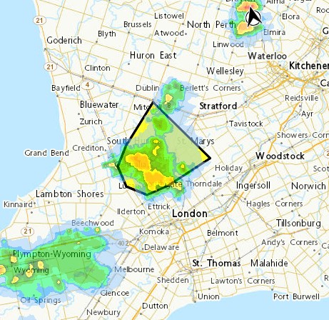
Figure 1: A targeted severe thunderstorm warning polygon can be seen over radar images of an active storm system, as it would appear on the Weather Information Map found on Canada.ca/weather.
Many predetermined alert zones are large and geographically spread out, meaning a weather alert that affects one part of a zone may not affect another. Targeted warnings mean that people who receive an alert are more likely to experience impacts.
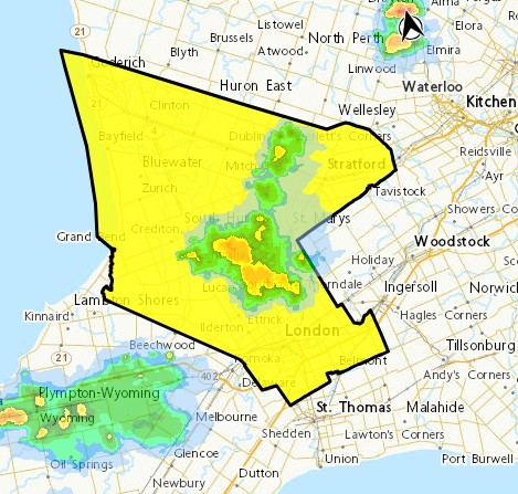
Figure 2: A severe thunderstorm warning issued to the pre-determined alert zone over the same storm system as Figure 1. This image highlights the contrast between targeted warnings and broader alert zones.
All other types of weather alerts (for example, rain or heat) will continue to be issued to the broader pre-determined alert zones, including severe thunderstorm and tornado watches.
Implementing polygons is a major technical undertaking. Because of this, we are incorporating them into our alert system gradually. We are applying them first to severe thunderstorms and tornadoes, as these hazards benefit the most from using polygons because they tend to be more localized compared to other types of alerts.
Faster
Our forecasters can now issue severe thunderstorm and tornado warnings faster than ever before, thanks to improved tools coupled with more streamlined processes.
Using advancements in semi-automated text generation, storm information can be generated simultaneously in both English and French before being sent directly to users. This allows our meteorologists to communicate their severe weather expertise much faster, giving Canadians the information they need to act quickly and stay safe.
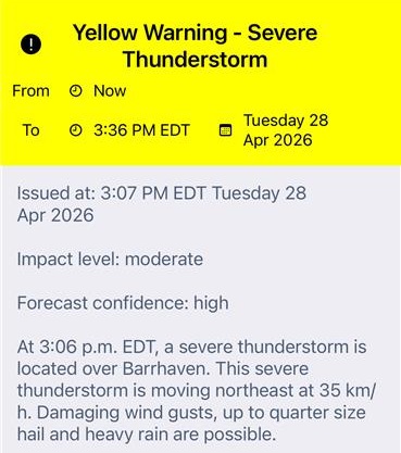
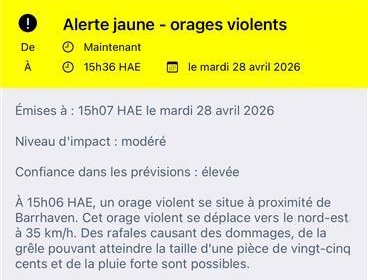
Figure 3: Example of a portion of a severe thunderstorm warning as it would appear on the WeatherCAN app in both English and French.
Flexible
Our forecasters can now issue multiple severe thunderstorm or tornado warnings in the same area at the same time, even overlapping them. This makes it possible to track different threats within the same, or different, storm systems.
This new ability allows forecasters to provide detailed storm-specific information, such as timing and location, as well as target safety guidance to each hazard.
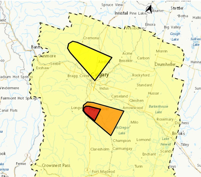
Figure 4: Example of targeted warning polygons as they appear on the Weather Information Map on Canada.ca/weather. The red tornado warning polygon is layered over an orange severe thunderstorm warning polygon, and a separate yellow warning polygon is also visible. These polygons are overlaid on top of a yellow severe thunderstorm watch that was issued using the pre-determined alert zone.
Forecasters also now have more freedom to manipulate the targeted warning polygons. Polygons can be both split and merged as a dynamic storm system moves through a region.

Figure 5: Example of two warning polygons merging into a single larger polygon. In this case, two isolated severe thunderstorms evolved into a continuous line, requiring the forecaster to merge the polygons.
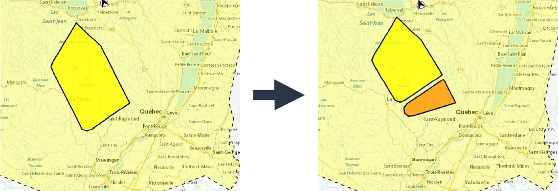
Figure 6: Example of a yellow polygon being split. In this scenario, one section of a storm system likely increased in severity, requiring an upgrade to a separate orange severe thunderstorm warning.
Alert Ready
Alert Ready delivers timely information about imminent, life-threatening events to at-risk Canadians so they can take action to protect themselves, their families, and their properties. It was built through a collaboration between emergency management organizations and a broad cross section of private-sector stakeholders, including broadcasters, cable TV, and mobile service providers.
Canadians will not see a noticeable change to weather-related alerts broadcast on TV and radio via the Alert Ready system after the switch to targeted severe thunderstorm and tornado warnings. However, wireless Alert Ready alerts to mobile phones will benefit from the added precision of warning polygons to better target who will receive the alerts.
Environment and Climate Change Canada only issues specific weather alerts through the Alert Ready system:
- tornado warnings
- severe thunderstorm warnings that meet these criteria:
- wind gusts of 130 km/h or greater
- hail the size of a baseball or greater (7cm)
WeatherCAN
Targeted severe thunderstorm and tornado warnings will affect weather alert notifications on the WeatherCAN app:
- Users with Android devices will only receive alert notifications for severe thunderstorm or tornado warnings when they (or their saved locations) are directly within a polygon.
- Users with Apple devices will receive notifications for warnings when a polygon is in their (or their saved locations’) alert zone, even if they are not directly in the polygon itself. These notifications will state that a warning is ‘nearby’.
Other mobile weather apps might show other notifications for targeted severe thunderstorm and tornado warnings:
- We are providing the new warning information, including polygon shapes, to all our weather alerting partners. This means that other apps can adopt targeted warning polygons at the same time as WeatherCAN.
- We will also continue to share zone-based alerting information, allowing third-party providers to transition on their own timelines.
For the latest forecasts and severe weather alerts, visit Canada.ca/weather or download the WeatherCAN mobile app, available for free for Android and iOS devices.