
The Georgia Basin-Puget Sound Airshed Characterization Report 2014: chapter 3
3. Air Quality and Weather
Bruce Thomson and Rebecca Saari (Environment Canada)
Wind transports and disperses airborne chemicals, and therefore air movement is critically important to understanding air quality. The short-term (hourly to daily) movement of air pollutants within the Georgia Basin/ Puget Sound airshed is controlled by the modification of large-scale weather systems by the local topography and variations in surface temperature and pressure. This chapter describes the principal meteorological processes affecting air quality, beginning with large (synoptic scale) weather patterns, and concluding with local (mesoscale) effects.
3.1 Weather Patterns in the Pacific Northwest
3.1.1 Seasonal Circulation and the Storm Track
General atmospheric circulation is driven by the Earth’s relative position and orientation to the Sun. Differential solar heating causes warm air at the equator to rise while cold air sinks at the poles, setting up a south-to-north flow of wind at high levels and a compensating north-to-south flow near the surface. This flow is deflected as the earth spins on its tilted axis, creating a general west-to-east movement of air in temperate latitudes. Air which has remained over an area for an extended period and has taken on distinctive characteristics of temperature and humidity is referred to as an air mass. For example, air moving across the north Pacific in winter takes on characteristics referred to as “maritime arctic”. Air moving from the tropical Pacific is known as a “maritime tropical air mass”. Boundaries between these air masses can be fairly abrupt; these boundaries are called fronts, and are classified as cold or warm depending on whether cold air is advancing or retreating. Weather systems are often embedded in a well-defined band of winds in the mid-levels of the atmosphere called the jet stream (sometimes called the storm track). This simplified view of atmospheric circulation is complicated significantly by topography, as well as changing surface properties, sea-surface temperatures, and seasons. Weather systems approach the Pacific Northwest from the southwest through northwest (Phillips, 1990), depending on the season. The direction of approach and the frequency of these systems depend on the location of the jet stream, which shifts north in summer and south in winter (Figure 3.1 and 3.2). The airshed is generally under the influence of the Aleutian Low during the winter and Subtropical High in the summer. In the summer, storms are infrequent because the jet stream generally lies north of the airshed, the Aleutian Low is weakened, and the Subtropical High is strong and tends to spread northward often building a ridge of high pressure over the area. This pattern often leads to stagnant conditions within the airshed.
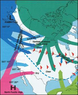
Figure 3.1 Winter air masses and circulation over North America (Phillips, 1990).
Description of Figure 3.1
Figure 3.1 is a simple line-drawing map of North America showing the general influence of five different air masses on the continent during winter. Each air mass is depicted as a large colored area with arrows extending from it indicating its area of influence. A large air mass over the Arctic influences the northern territories of Canada, the Canadian prairies, Ontario, and Quebec as well as the US Midwest and northeast. An air mass over the Gulf of Mexico influences the southern US. The North Pacific High off of the west coast of Mexico influences the west coast of the continent as far north as Washington State. The Aleutian Low in the Gulf of Alaska influences the BC and Washington Coasts including the Georgia Basin/Puget Sound airshed. Another air mass lying off the US west coast also impacts the west coast from California to Haida Gwaii. The jet stream dips south from the southern border of Washington State to the Gulf of Mexico. Rain and snow is indicated along the Coast Mountains. The Canadian prairies have a note that upslope produces cloud and snow. The area in the US north of the jet stream is indicated as clear with the area in the US south of the jet stream indicated as dry. Snow and blizzards are indicated in northern British Columbia and Alberta and into Nunavut and the North West Territories.
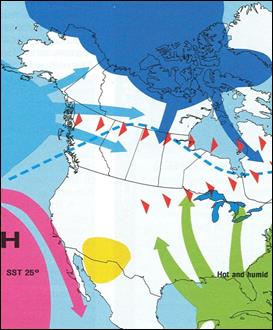
Figure 3.2 Summer air masses and circulation over North America (Phillips, 1990)
Description of Figure 3.2
Figure 3.2 is the same line-drawing map of North America as seen in Figure 3.1, but in this case showing the general influence of five different air masses on the continent during summer. In summer an air mass over the Arctic influences the Canadian territories, the northern prairies, and northern Quebec. An air mass in the Gulf of Mexico influences the US east of a line between the Great Lakes and the eastern Mexican border and this area is indicated as hot and humid. A small air mass sits over the US/Mexico border east of the Sea of Cortez. The North Pacific High sits off the coast of California and the Baja. A fifth air mass off the BC coast sends air into northern BC, the Yukon, and Alaska. The jet stream passes over the northern tip of Vancouver Island and up to the southern border of Nunavut before heading east across northern Ontario and Quebec.
The storm track is positioned across the airshed in the autumn making October, November and December the wettest months of the year. The strongest and most frequent storms are in the autumn when the jet stream is very strong and is overhead and the Aleutian Low is strong.
The jet stream migrates south of the area in January and February, leaving the airshed in colder, generally drier air masses. Often all of the storm energy is directed to areas south of the airshed, which can result in colder arctic air occasionally pushing out to coastal areas from the interior of the continent.
The jet stream returns to the airshed in March and April. When the jet stream passes overhead in the spring it is at its strongest and is oriented from southwest to northeast across the North Pacific Ocean. This orientation is favourable for the transport of dust and other pollutants from Eurasia.
3.1.2 Weather Patterns Affecting Long-Range Pollutant Transport
Synoptic scale wind flows are responsible for transporting air pollutants over long distances. It has been noted that airborne chemicals from Eurasia and California, for example, add to the overall mixture of pollution within the airshed (Belzer, 1997).
As mentioned above, the circulation pattern that is most effective for transporting pollutants across the Pacific Ocean arises during the spring, particularly April and May.
Air pollutants from the south (e.g., Oregon and California) and from the north (e.g., northern British Columbia, the Yukon, and Alaska) are also transported to the Pacific Northwest under specific weather conditions. Transport from the south in summer is associated with the Southwest Monsoon, a trough of low pressure created in the Great Basin and Interior Pacific Northwest by surface heating, and upper-level low pressure over the west coast states. These conditions often come with isolated or occasional thunderstorms along the eastern slopes of the Cascades and the interior mountain ranges. This is a fairly common weather pattern in the summer, especially in the month of June.
Air pollutants from distant sources are usually well dispersed by the time they arrive in the airshed, adding small but measurable amounts to ozone, particulate matter (PM), and other trace pollutants to background concentrations. Occasionally these long-range transported pollutants can result in poor visibility and exceedences in air quality standards and objectives. The significance of long-range transport is explored in Chapter 11: Transboundary Transport.
3.2 Airflow in the Airshed
The geography of the airshed includes the Pacific Ocean, the Straits of Juan de Fuca and Georgia, and mountain ranges reaching altitudes well above 1,500 metres. By channelling and containing air pollutants, these natural features play a major role in the transport and fate of airborne pollutants.
The synoptic-scale winds are modified in the lowest layers of the atmosphere (from the surface to about 1,500 metres aloft) by local topography. While dependent on the active synoptic-scale weather pattern, the mesoscale circulation through and around topographic features often dictates air pollution concentrations at different locations within an airshed.
3.2.1 Topography of the Airshed
The Georgia Basin is dominated by the west-to-east axis of the Lower Fraser Valley, the northwest-to-southeast Strait of Georgia and the west-to-east Strait of Juan de Fuca. This is in contrast to the well-defined north-south alignment of the Puget Sound airshed. The southern portion of the Puget Sound airshed is affected by air flowing through the Chehalis Gap from the Pacific Ocean. Both airsheds are influenced by the flow of air up and down “tributary” valleys and mountain slopes.
3.2.2 Airflow within Puget Sound
Puget Sound is oriented in a north-to-south direction, with the Cascade Mountains to the east reaching 2,000 to 2,500 metres and forming a significant barrier parallel to the Sound, and the Olympic Mountains rising to 1,500 to 2,000 metres to the west and north. The major pathways for air entering and leaving the Sound are the Chehalis Gap to the southwest and Haro Strait to the north. Tributary valleys that cut into the Cascade Mountains also play an important role in the overall flow of air within the Sound. The basic flow of air within Puget Sound is either north-to-south or south-to-north, controlled by large-scale weather features, local topography, and temperature differences between central and southern areas of the Sound. Perturbations to this flow regime are caused by the influence of large weather disturbances that allow low-level maritime air to enter the interior portions of western Washington through the Chehalis Gap and Strait of Juan de Fuca. The mountainous orography provides slopes and valleys that contribute to complex mesoscale airflows (Cokelet, 1991).
Large weather systems approaching the coastal areas of Washington dictate the way in which air flows through Puget Sound. Disturbances that track north of the area cause a southerly flow to develop within Puget Sound, with air travelling out of the area through Haro Strait. Even when the main part of a weather system goes to the south, winds are often southerly before a front and westerly after a front because the Aleutian Low is such a strong influence on regional winds. When the Aleutian Low is weakened in the Eastern Pacific and a storm moves to our south, northerly winds in Puget Sound result.
In the wake of weather systems, especially in the spring, westerly flows around the Olympic Mountains through the Chehalis Gap and the Strait of Juan de Fuca cause these flows to meet within Puget Sound, creating an area of enhanced cloud and precipitation called the “Puget Sound Convergence Zone” (Chien et al., 1997).
Westerly to southwesterly winds enter the airshed through the Chehalis Gap and join with southerly winds that dominate the Puget Sound area. Easterly outflow winds are experienced from tributary valleys on the east side of the Sound. As the system continues to track eastward, winds in the Sound shift to the north and northwest, and tributary valleys experience westerly winds.
3.2.3 Airflow within the Georgia Basin
The Georgia Basin portion of the airshed includes a portion of the eastern coast and southern tip of Vancouver Island, Haro Strait, the Strait of Georgia and the Lower Fraser Valley. The Lower Fraser Valley is bounded to the west by the Strait of Georgia, to the north by the Coast Mountains (North Shore Mountains) and to the east and south by the Cascade Mountains. The triangular shape created by these geographic features contains Metro Vancouver, the Fraser Valley Regional District and the Whatcom County portion of Washington State.
The Georgia Basin is influenced by transient weather disturbances from the Pacific in a similar way to that of Puget Sound. Weather systems moving to the north of the area create strong winds through valleys in the Vancouver Island ranges; the “Qualicum winds” are an example of this phenomenon. Winds in the Strait of Georgia tend to blow from the southeast, supported by outflows from Howe Sound and the Lower Fraser Valley.
A weather system moving toward the coast from the northwest will have a different impact on local winds in the Georgia Basin from that in the Puget Sound. In Puget Sound, the flow in many of the valleys will remain easterly to southeasterly, while in the Georgia Basin, winds in Georgia Strait will be southeasterly, shifting to westerly in the Strait of Juan de Fuca. A more in-depth analysis of these wind flow patterns can be found in Lange (1998) or Mass (2008).
A weather disturbance moving to the south of the area will cause outflow winds from Howe Sound and the Lower Fraser Valley, but the winds in the Strait of Georgia will be northwesterly. Weather systems approaching from the southwest will similarly cause winds to flow out of the Lower Fraser Valley and marine areas, toward the approaching system. This causes easterly outflow winds in many areas, which are accompanied by northwesterly to northeasterly winds in Georgia Strait. As the weather system moves over the coast into the interior, winds shift to westerly and northwesterly. A detailed description of these wind patterns can be found in Lange (2003).
3.2.4 Local Flow Patterns
There are times when the Pacific Northwest or portions of the area are not being influenced by active weather systems following the storm track. At these times, mesoscale circulation patterns become increasingly important. Upslope and downslope flows and sea-to-land breeze circulations are two types of local flow patterns that are caused by local topography coupled with local variations in temperature. Most of the Georgia Basin and Puget Sound are influenced by mountainous terrain with winds channelling up and down the valleys. The diurnal movement of the sun creates temperature differences that cause air to rise in one area and descend in another.
3.2.5 Airflow between Puget Sound and the Georgia Basin
Wind patterns in the airshed vary continually in response to transient weather systems. Rapid shifts in wind patterns can transport air pollutants from the Georgia Basin to the Puget Sound and back again. The winds that are most effective at transporting pollutants reside in the lower portions of the atmosphere below about 1,500 metres. This airflow moves pollution freely from emission sources to receptor areas, restricted only by local topography.
Referring back to Figure 1.1, the area at the north end of Puget Sound that is bordered by Haro Strait to the north, and by high topographic features (greater than 1,500 metres) to the east and west, represents an important portal for the exchange of air pollutants between the Puget Sound and Georgia Basin airsheds.
Both local topography and large-scale weather are known to affect the exchange of air pollutants between the Georgia Basin and Puget Sound airsheds. Frequently pollutant concentrations rise in their source airsheds during stagnant conditions, then move to adjacent airsheds as these stagnant conditions break down. Mechanisms and impacts of transboundary transport are covered in Chapter 11: Transboundary Transport.
3.3 Weather Patterns Conducive to Poor Air Quality
Each weather pattern plays its own role in the air quality of the airshed. Certain weather patterns are particularly conducive to the accumulation of air pollutants. Periods of poor air quality are most likely to occur when weather conditions such as light winds and subsidence inversions combine to trap pollutants in the airshed, or when certain strong flows generate wind-borne dust.
The weather patterns that create very light winds over the Georgia Basin/Puget Sound are the most important from an air pollution perspective. An area of high pressure will build over the Pacific Northwest, usually supported by very light air circulation aloft. The absence of well-developed air circulation allows land/sea breezes and slope winds to dominate. A land/sea breeze, caused by temperature differences between land and water, creates an inflow of air from the water beginning in mid-morning and continuing through the early evening, then switching to an outflow overnight. The flow of air up and down the slopes of valleys is another important circulation pattern that is caused by differential heating of the slopes. These light, variable wind patterns may last for several days.
Periods of stagnation often occur in the summer and winter, making these seasons more important to air quality. During these two seasons, winds may be light and variable, as the storm track is either north or south of the area. In the winter, these relatively quiet periods allow cold arctic air masses to move westward from the interior. The cold arctic air creates stagnant conditions with strong temperature inversions through many of the valleys. If these conditions are coupled with the movement of a larger Pacific weather system, strong easterly outflow winds can develop. The summer period is dominated by areas of high pressure over the eastern Pacific Ocean and frequently over the Pacific Northwest. It is during these periods, when the Georgia Basin and Puget Sound are under the influence of high atmospheric pressure, that the airflow in both airsheds is reduced to localized circulations. Temperature inversions are common with this type of weather pattern. The storm track is far to the north, deflecting weather systems into Alaska and northern British Columbia. These periods of light winds and strong temperature inversions produce the most severe air quality events within the Pacific Northwest.
Stagnant weather patterns often influence the Georgia Basin and Puget Sound at the same time. An upper ridge moves over the airshed, creating light surface winds due to very weak pressure gradients. The summer stagnation periods are associated with a “thermal trough” west of the Cascades created under clear skies and strong solar heating. This surface feature suppresses the land/sea breeze in the Lower Fraser Valley and Puget Sound. The characteristic “Sound breeze” that blows from north to south in Puget Sound is also suppressed, creating nearly calm conditions (Steenburgh, 1996) that allow surface temperatures to increase. An offshore pressure gradient pulls air over the Cascade Mountains, establishing a subsidence inversion over the Puget Sound airshed, trapping pollutants. In the Lower Fraser Valley, a similar set of weather events suppresses the land/sea breeze, although, with the east-to-west orientation of the valley, the subsidence inversion is controlled by the ridge aloft. The effect of these nearly identical weather patterns is to effectively isolate the two airsheds from one another. Wind flow patterns that are established during these stagnant periods do not allow air pollutants to flow from one airshed to another. The suppressed land/sea breeze circulation in the Georgia Strait effectively decouples the airflow from eastern Vancouver Island as well.
3.4 Weather Patterns Affecting Ozone and Particulate Matter
The atmospheric conditions that promote the photochemical production of ozone are well known within the Georgia Basin/Puget Sound airshed. Ozone episodes have been documented where concentrations have reached levels well in excess of national air quality objectives. The occurrence of ozone episodes is dependent on specific weather patterns, as described previously. Even during a period when emissions of ozone precursors (NOx and VOCs) are stable, a stagnant meteorological pattern bringing clear skies and hot temperatures can quickly produce elevated ozone concentrations.
3.4.1 Air Quality Impacts of Weather in the Lower Fraser Valley (adapted from Environment Canada, 2010)
Several recent studies have documented the air quality impact of weather patterns in the Canadian Lower Fraser Valley portion of the airshed. Summer stagnation periods lasting several days have been linked to episodes of elevated ozone and PM2.5 and degraded visibility. Exceedences of the National Air Quality Ozone Objective of 82 ppb at the coastal Vancouver International Airport have been associated with coastal winds from the northwest and from the southwest associated with sea-breeze conditions (Ainslie and Steyn, 2007).
An examination of flow patterns during the sea breeze- land breeze cycle helps to explain the transport of pollutants across communities within the Canadian Lower Fraser Valley, and the appearance of high concentrations in the eastern part of the valley. Light flows associated with sea breeze conditions effectively funnel and concentrate primary and secondary pollutants originating from more populated urban source areas in the west towards the narrowing eastern extent of the valley and communities such as Chilliwack and Hope.
During sea-breeze conditions, pollutants are advected inland during the day, and this process can be enhanced by upslope flows from the mountains that border the valley to the north (North Shore Mountains) and to the south east (Cascade Mountains) Consequently, by evening, pollutant plumes can move up mountain slopes and into elevated tributary valleys where they accumulate and undergo chemical processing. This flow pattern can also result in layers of concentrated pollutants aloft, especially towards valley apexes (Strawbridge and Snyder, 2004). During the night, drainage and land breeze flows and the formation of a shallow nocturnal boundary layer lead to a concentration of aerosols and primary pollutants near the surface and in layers above the boundary layer. In many locations ozone drops to very low concentrations due to titration by NO and deposition within the shallow boundary layer. During the late night and early morning, the land-breeze transports aerosols from the eastern part of the WISE and tributary valleys westward towards the Strait of Georgia, resulting in an increase in aerosols and primary pollutants (e.g., NOx) over the water. In the morning, the nocturnal boundary layer breaks up, and elevated layers still containing ozone, primary and secondary PM and some precursors species (e.g., NOx) are mixed down to the surface (McKendry et al., 1997; Pisano et al., 1997).
Pollutant transport has also been shown to be influenced by a process known as the Wake-Induced Stagnation Effect (WISE) (Brook et al., 2004). This occurs as a result of light winds from the Strait of Georgia and Strait of Juan de Fuca converging together, coupled with a “wake” effect induced by the geographical features of the Vancouver, Gulf, and San Juan islands. During the Pacific 2001 Air Quality Study, WISE was associated with the advection and buildup of concentrated aerosol layers over the Gulf/San Juan islands (Strawbridge and Snyder, 2004). Within these aerosol layers, pollutants underwent photochemical processing and were then re-circulated via the sea/land-breeze cycle. The advection of aged aerosols and gases (ozone, oxidized nitrogen compounds) from the WISE zone was observed to impact the WISEand adjacent Whatcom County area of northwestern Washington State and be repeated over several days, resulting in a build-up of concentrated and increasingly aged pollutants.
During these stagnant, summer anti-cyclonic conditions, with a land/sea breeze, daytime concentrations of PM10 may reach 50 to 75 mg/m3, and peak PM2.5 concentrations between 20 and 30 μg/m3 are not uncommon. While these stagnant, sea-breeze conditions also favour high ozone levels, there is only a weak correlation between ground-level ozone and PM10 concentrations (McKendry, 2000). Secondary particle formation, which has been linked to visibility degradation (Pryor and Barthelmie, 1999), becomes very active during summertime subsidence inversions and progresses even further during prolonged periods of stagnation and inflow/outflow conditions.
While stagnant conditions can lead to elevated levels of gaseous pollutants, high winds can lead to dust events. In eastern portions of the Lower Fraser Valley, outflow winds are strong enough to pick up soil and sand, creating levels of PM10 that exceed air quality standards. These outflow conditions develop when a ridge of high pressure builds over interior portions of BC and Washington. The resultant surface pressure gradient drives the outflow that may last for two or three days. Furthermore, a few times each winter, these outflow winds bring cold Arctic air from the interior regions through the mountain valleys to the coastal areas. As the Arctic air mass is shallow, strong temperature inversions develop, creating stagnant conditions over the WISE and tributary valleys as the pressure gradients and winds relax. The temperature inversions further strengthen with prolonged surface cooling during the long winter nights. These conditions, coupled with increased wood smoke emissions during the colder seasons, can lead to elevated levels of PM in the WISEairshed.
Magnitude and Frequency of Stagnation Conditions
A study by Environment Canada looked at the importance of stagnation patterns in terms of magnitude and frequency. This study investigated weather patterns and air quality concentrations (O3 and PM) using statistical approaches to determine the types of weather patterns that caused stagnant conditions and elevated pollutant concentrations (Cannon et al., 2002). This analysis is described in terms of the frequency of occurrence of various synoptic “map types”. Figure 3.3 and Figure 3.4 depict the surface and upper level pressure patterns, respectively, when concentrations of ozone were elevated and fine particulate matter concentrations were above the regional mean. These weather patterns agree with other analyses mentioned earlier, which identified the presence of a ridge aloft and very weak surface pressure gradients. This summer weather pattern occurred nine times over the 11-year study period. The analysis considered elevated concentrations of ozone and PM separately. The weather patterns were similar to those of Figure 3.3 and Figure 3.4, but the frequency of occurrence was different. Elevated ozone concentrations during the summer months resulted from weather patterns occurring 78 times through the study period.
For the entire airshed, conditions were conducive to the production of elevated PMconcentrations 46 per cent of the time. The PM weather pattern indicated a surface low pressure centre displaced to the west off the west coast and a much stronger offshore gradient aloft. The highest frequency of weather patterns leading to high PM concentrations occurred in spring and winter. Elevated PMconcentrations during the summer were often associated with the stagnant meteorology that produced elevated ozone concentrations. The weather patterns producing elevated PM concentrations with ozone levels above the regional mean (the reverse of the first case described above) occurred primarily in the spring and fall.
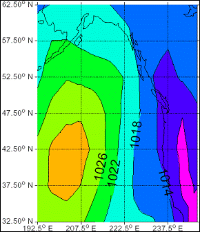
Figure 3.3 Surface pressure (contours in millibars) pattern when ozone concentrations are elevated and PM concentrations are above the regional mean.
Description of Figure 3.3
Figure 3.3 is a pressure contour map extending from 32.50°N to 62.50°N and from 192.50°E to approximately 247.5 °E. The highest pressure region (1030mb) is offshore of the US coast and extends from just below 37.50°N to almost 47.50°N and falls between 192.5°E and 207.5°E. The next contour (1026mb) extends from below 32.50°N to the waters offshore of Haida Gwaii and from west of 192.5°E to approximately 215°E. The 1022mb contour reaches as far north as the gulf of Alaska and as far east as 222.5°E. The 1018mb contour runs north-south the full extent of the map passing through the Alaskan panhandle and just offshore of Haida Gwaii. The 1014mb contour extends from the northern BC interior, through the northern tip of Vancouver Island and south just off the US coast. The final contour is at 1010mb and encompasses the interior of southern Washington, Oregon, and California.
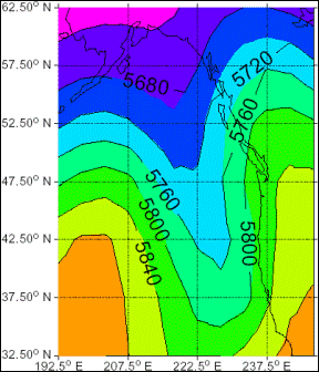
Figure 3.4 Upper height (500 mb pressure contours in metres) pattern when ozone concentrations are elevated and PM concentrations are above the regional mean.
Description of Figure 3.4
Figure 3.4 is the same pressure contour map as shown in Figure 3.3 (extending from 32.50°N to 62.50°N and from 192.50°E to approximately 247.5°E). This map shows the height of the 500mb pressure contours in meters. The contours follow a sinusoidal pattern with most showing two peaks and one valley in the map area. Only one peak is visible for the lowest altitude contour (5640m) and this occurs in the Alaskan interior at 60°N and 205°E. The 5680 m contour peaks in the Aleutian Islands at approximately 56°N and 200°E with a valley is in the gulf of Alaska at approximately 55 °N and the second peak in the interior of the Yukon territory at 62.50°N and approximately 230.0°E. The 5720m contour peaks south of the Aleutian Islands at approximately 53°N and again in the southeastern Yukon at approximately 60.0°N. The 5760m contour peaks just west of 207.5°E at approximately 50°N and at 237.5°E by the BC/Yukon border. The 5800m contour peaks just west of 207.5°E at approximately 48°N and at 237.5°E just above 52.50°N. Its lowest point is at approximately 35°N and 222.5°E. The 5840m contour peak in the offshore waters at 45°N and 200°E ad well as near the BC/Washington border at approximately 50.0°N and 240°E. Its valley falls below the lower edge of the map. For the 5880m contour only one peak is visible at 42.50°N and 200°E, the other occurs somewhere in the California interior.
3.5 Chapter Summary
Air quality is heavily affected by weather patterns, which are influenced by local topography and variations in surface temperature and pressure. Once the pollutants become air-borne, the path by which they travel is controlled by global, regional and local processes and can have a strong role in determining the magnitude of air pollution concentrations at particular locations within the airshed.
In the Georgia Basin/Puget Sound airshed, periods of poor air quality are most likely to occur when weather conditions characterized by light winds and subsidence inversions combine to trap pollutants. During these periods of light winds, the absence of well-developed air circulation allows local processes such as land/sea breezes and slope winds to dominate. Light flows associated with sea-breeze conditions can effectively funnel and concentrate pollutants originating from the more populated urban west, towards the narrowing eastern extent of the valley and communities such as Hope and Chilliwack. This process can be enhanced by upslope flows along the mountains, where pollutant plumes move up the mountain slopes and accumulate in the elevated tributary valleys.
Periods of stagnation often occur in the summer and winter, making these seasons more important to air quality. During these two seasons, the wind flow patterns may be light and variable and the airflow in both airsheds is reduced to localized circulations, due to the influence of high atmospheric pressure in the summer and the movement of cold arctic air masses and larger Pacific weather system in the winter. Strong temperature inversions are common with these weather patterns. Some of the most severe air quality events within the Pacific Northwest are produced by periods of light winds coupled with strong temperature inversions.
While stagnant conditions can lead to elevated levels of gaseous pollutants, high winds can lead to dust events. Strong outflow winds occasionally pick up soil and sand, creating high levels of PM10 which can exceed air quality standards. Furthermore, during the winter, outflow winds periodically bring cold arctic air from the interior regions through the mountain valleys to the coastal areas, creating stagnant conditions over the Canadian Lower Fraser Valley with strong temperature inversions in the tributary valleys. These conditions can lead to wintertime PM episodes in the area.
Environment Canada investigated the importance of stagnation patterns in terms of magnitude and frequency in Vancouver, British Columbia. Results identified the presence of a ridge aloft and very weak surface pressure gradients, when ozone concentrations are elevated and PMconcentrations are above the regional mean. Similar weather patterns were found for instances of elevated ozone and PM, separately. The frequency of occurrence was greater for elevated ozone than PM concentrations during the summer months. The highest frequency of weather patterns leading to high PMconcentrations occurred in the spring and winter; the weather patterns producing elevated PM concentrations with ozone levels above regional mean occurred primarily in the spring and fall.
3.6 References
Ainslie, B. and D.G. Steyn, 2007. Spatio-temporal Trends in Episodic Ozone Pollution in the Lower Fraser Valley, British Columbia, in Relation to Mesoscale Atmospheric Circulation Patterns and Emissions. Journal of Applied Meteorology and Climatology 46: 1631 - 1644.
Belzer, W., Poon, A., and Evans, C., 1997. Atmospheric Concentrations of Agricultural Chemicals in the Lower Fraser Valley. Fraser River Action Plan, Report 1997-31. Environment Canada, 1997, 20 pp.
Brook, J., Strawbridge, K., Snyder, B., Boudries, H., Worsnop, D., Anlauf, K., Sharma, S., Lu, G., and Hayden, K., 2004. Towards an understanding of the fine particle variations in the LFV: integration of chemical, physical and meteorological observations. Atmospheric Environment 38: 5775-5788.
Cannon, A., Whitfield, P., and Lord, E., 2002. Synoptic map-pattern classification using recursive partitioning and principal component analysis. Monthly Weather Review 130(5): 1187-1206.
Chien, F., Mass, C., Kuo, Y., 1997. Interaction of a warm-season frontal system with the coastal mountains of the western United States. Part I: Prefrontal onshore push, costal riding and alongshore southerlies. Monthly Weather Review 125(8): 1730-1752.
Cokelet, E, 1991. Axial and Cross-axial winter winds over Puget Sound. Monthly Weather Review 120: 826-834.
Environment Canada, 2010. The 2008 National Smog Report. Internal Draft.
Lange, O., 1998. The wind came all ways: a quest to understand the winds, waves and weather in the Georgia Basin. Environment Canada. ISBN 0-660-17517-7, 122 pp.
Lange, O., 2003. Living with weather along the British Columbia coast: the veil of chaos. Environment Canada. ISBN 0-660-18984-4, 198 pp.
Mass, C., 2008. The Weather of the Pacific Northwest.University of Washington Press: Seattle, 2008.
McKendry, I.G., 2000. PM10 Levels in the Lower Fraser Valley, British Columbia, Canada: An Overview of Spatiotemporal Variations and Meteorological Controls. Journal of the Air & Waste Management Association 50: 443-445.
McKendry, I., Steyn, D., Lundgren, J., Hoff, R., Strapp, W., Anlauf, K., Froude, F., Martin, J., Banta, R., Olivier, L., 1997. Elevated ozone layers and vertical down-mixing over the Lower Fraser Valley, BC. Atmospheric Environment 31: 2135-2146.
Phillips, D., 1990. The Climates of Canada. Environment Canada. ISBN 0-660-13459-4, 159 pp.
Pisano, J., McKendry, I., Steyn, D., Hastie, D., 1997. Vertical nitrogen dioxide and ozone concentrations measured from a tethered balloon in the Lower Fraser Valley. Atmospheric Environment 31: 2071-2078.
Steenburgh, W., and Mass, C., 1996. Synoptic and mesoscale circulations during high ozone episodes over western Washington: An evaluation of the Penn State/NCAR Mesoscale Model (MM5). Report to the Puget Sound Air Pollution Control Agency, 67 pp.
Strawbridge, K. and Snyder, B., 2004. Daytime and nighttime aircraft measurements showing evidence of particulate matter transport into the northeastern valleys of the Fraser Valley, B.C. Atmospheric Environment 38: 5873-5886.