
Great Lakes drainage basin map
The Great Lakes are a vast shared resource. They contain roughly 18% of the world supply of fresh surface water, and 84% of North America’s supply. They are home to millions of people, and are fundamental to the well-being of one third of the population of Canada and one tenth of the population of the United States. As our home and playground, the Great Lakes provide the foundation for billions of dollars in trade, shipping, manufacturing, fishing, forestry, agriculture, mining, energy and tourism and they are a direct source of drinking water for 10 million Canadians. Water from the Great Lakes drains into the St. Lawrence River, and therefore that ecosystem is directly affected by the quality and quantity of water from the Great Lakes. The Great Lakes basin supports a diverse, globally significant ecosystem that is essential to the resource value and sustainability of the region.

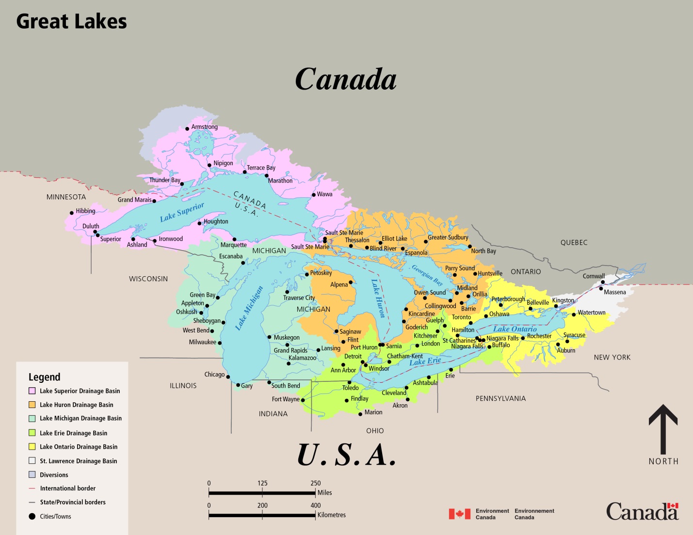
Map: The Great Lakes Drainage Basin
A map shows the five Great Lakes (Lake Superior, Lake Michigan, Lake Huron, Lake Erie, and Lake Ontario), and their locations between two countries - Canada and the United States (US). The map, whose scale is in hundreds of kilometres and is oriented in the north direction, shows the five Great Lakes drainage basins, diversions, and all provinces, states, cities, Areas of Concern (AOC), and tributaries within them.
The Canadian provinces shown are Ontario and Québec. The US states shown are Minnesota, Wisconsin, Illinois, Indiana, Ohio, Pennsylvania, and New York. The international border between Canada and the US runs between the borders of Ontario the states of Minnesota, Michigan, Ohio, Pennsylvania, and New York. Canadian cities shown (all in Ontario): Lake Superior Drainage Basin: Thunder Bay, Armstrong, Nipigon, Terrace Bay, Marathon, Wawa, and Sault Ste. Marie. Lake Huron Drainage Basin: Thessalon, Blind River, Elliot Lake, Espanola, Greater Sudbury, North Bay, Parry Sound, Huntsville, Midland, Orillia, Barrie, Collingwood, Owen Sound, Kincardine, Goderich, and Sarnia. Lake Erie Drainage Basin: Windsor, Chatham-Kent, London, Kitchener, and Guelph. Lake Ontario Drainage Basin: Niagara Falls, St. Catharines, Hamilton, Oshawa, Peterborough, Belleville, Kingston, and Toronto. US cities shown: Minnesota, Lake Superior Drainage Basin: Grand Marais, Hibbing, and Duluth. Wisconsin, Lake Superior Drainage Basin: Superior, and Ashland. Wisconsin, Lake Michigan Drainage Basin: Green Bay, Appleton, Oshkosh, Sheboygan, West Bend, and Milwaukee. Michigan, Lake Superior Drainage Basin: Ironwood, Houghton, Marquette, and Sault Ste. Marie. Michigan, Lake Michigan Drainage Basin: Escanaba, Petoskey, Traverse City, Muskegon, Grand Rapids, Kalamazoo, and Lansing. Michigan, Lake Huron Drainage Basin: Alpena, Saginaw, and Flint. Michigan, Lake Erie Drainage Basin: Port Huron, Detroit, and Ann Arbor. Illinois, coast of Lake Michigan: Chicago. Indiana, Lake Michigan Drainage Basin: Gary, and South Bend. Indiana, Lake Erie Drainage Basin: Fort Wayne. Ohio, Lake Erie Drainage Basin: Toledo, Findlay, Marion, Cleveland, Akron, and Ashtabula. Pennsylvania, Lake Erie Drainage Basin: Erie. New York, Lake Erie Drainage Basin: Buffalo. New York, Lake Ontario Drainage Basin: Niagara Falls, Rochester, Auburn, Syracuse, and Watertown. St. Lawrence River Drainage Basin: Massena.
Also shown on the map are tributaries. A tributary is a river or stream flowing into a larger river or lake. Forty-two tributaries to the five Great Lakes are shown within both Canadian and US lands: from Duluth, Minnesota, to Watertown, New York.
File Download: JPEG File Download(JPEG; 266 kb)
Page details
- Date modified: