
Bird conservation strategy for Region 13: Lower Great Lakes/St. Lawrence Plain boreal hardwood transition
Table of Contents
- Abridged version -
June 2014

- Preface
- Acknowledgements
- Bird Conservation Strategy for Bird Conservation Region 13 in Ontario Region: Lower Great Lakes/St. Lawrence Plain
- Executive summary
- Introduction: Bird Conservation Strategies
The abridged version of the strategy available here contains a summary of the results, but does not include an analysis of conservation needs by habitat, a discussion of widespread conservation issues, or the identification of research and monitoring needs.
Other formats available for this document:
Preface
Environment and Climate Change Canada led the development of all-bird conservation strategies in each of Canada’s Bird Conservation Regions (BCRs) by drafting new strategies and integrating new and existing strategies into an all-bird framework. These integrated all-bird conservation strategies will serve as a basis for implementing bird conservation across Canada, and will also guide Canadian support for conservation work in other countries important to Canada’s migratory birds. Input to the strategies from Environment and Climate Change Canada’s conservation partners is as essential as their collaboration in implementing their recommendations.
Environment and Climate Change Canada has developed national standards for strategies to ensure consistency of approach across BCR. BCR strategies will provide the context from which specific implementation plans can be developed for each BCR, building on the programs currently in place through Joint Ventures or other partnerships. Landowners including Aboriginal peoples will be consulted prior to implementation.
Conservation objectives and recommended actions from the conservation strategies will be used as the biological basis to develop guidelines and Beneficial Management Practices that support compliance with regulations under the Migratory Birds Convention Act, 1994. Furthermore, these strategies will guide conservation action in support of The State of Canada's Birds 2012 (North American Bird Conservation Initiative 2012), which points to the strong influence of human activity on bird populations, both positive and negative, and presents solutions towards keeping common birds common and restoring populations that are in decline.
Acknowledgements
Brigitte Collins and Paul Smith were the main authors of this document that follows templates developed by Alaine Camfield, Judith Kennedy and Elsie Krebs with the help of the BCR planners in each of the Canadian Wildlife Service regions throughout Canada. However, work of this scope cannot be accomplished without the contribution of others who provided or validated technical information, commented on draft versions of the strategy, produced maps and supported the overall planning process. We would like to thank the following for their contributions to this strategy: Gregor Beck, Graham Bryan, Mike Cadman, Alaine Camfield, Lesley Carpenter, Britt Dupuis, Christian Friis, Krista Holmes, Jack Hughes, Judith Kennedy, Sarah Mainguy, Shawn Meyer, Dave Moore, Jocelyn Neysmith, Marie-France Noel, Michele Rodrick, Daniel Rokitnicki-Wojcik, Paul Watton, Chris Wedeles and D.V. Weseloh.
Bird Conservation Strategy for Bird Conservation Region 13 in Ontario Region: Lower Great Lakes/St. Lawrence Plain
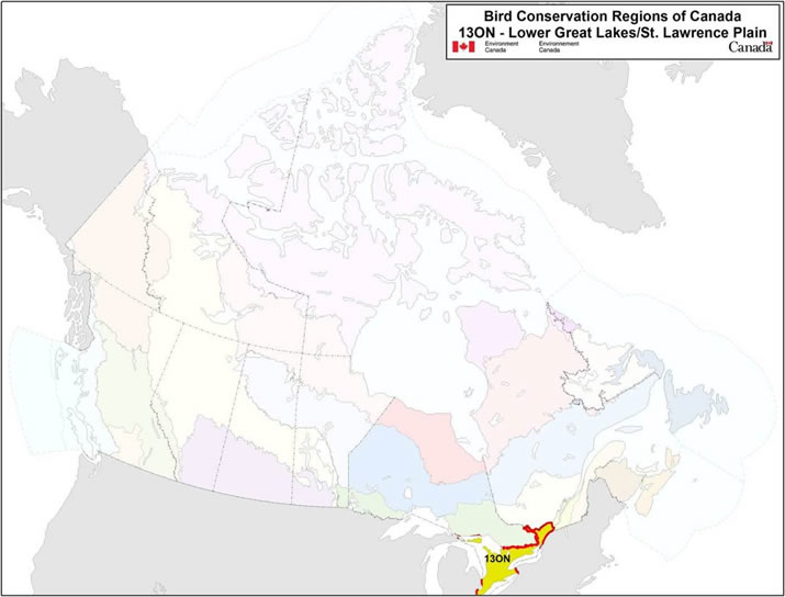
Long description for Map
Map of the Bird Conservation Regions (BCRs) of Canada with BCR 13 ON Lower Great Lakes / St. Lawrence Plain highlighted. The extent of the map includes Canada, with Alaska, Greenland and the northern portion of the U.S. also appearing. The map is divided by BCR (12 Canadian BCRs in total) and their exact locations and sizes are indistinguishable, aside from BCR 13 ON.
The highlighted BCR 13 ON covers the extreme south of the province, between lakes Huron, Erie and Ontario.
Legend: Bird Conservation Regions of Canada. 13 ON - Lower Great Lakes / St. Lawrence Plain; Environment and Climate Change Canada logo, and Government of Canada logo.
Executive summary
The Lower Great Lakes/St. Lawrence Plain Bird Conservation Region 13 (BCR 13) covers an area of 201,300 km2 across Ontario, Quebec and the United States (Ontario Partners in Flight 2008). In Ontario, the region includes those areas lying between the Canadian Shield and the shores of the Great Lakes. This conservation strategy for Ontario’s portion of BCR 13 (BCR 13 ON) builds on existing bird conservation plans and complements those created for the other BCRs across Canada. These strategies serve as a framework for implementing bird conservation nationally and also identify international conservation issues for Canada’s priority bird species. This strategy is not intended to be highly prescriptive, but rather is intended to guide future implementation efforts undertaken by various partners and stakeholders.
Southern Ontario is the most populous region of Canada. Approximately one in three Canadians lives here, and population growth continues to outpace that of the rest of the country. Humans have had a profound and irreversible effect on the landscape in this region. Dense, old-growth deciduous and mixed forests once covered 90% of the landscape but were reduced to only 10% by 1920 as lands were cleared for agriculture. Wetlands and natural grasslands also suffered substantial losses. Although agricultural lands still dominate BCR 13 ON, a trend towards reforestation has benefitted some species, and efforts to restore and protect wetlands and other habitat types are ongoing. Moreover, a number of unique natural habitats remain, including Carolinian forests, alvars and the Frontenac Arch. Each of these habitats supports an atypically high proportion of birds as well as species at risk. The coastal wetlands of the Great Lakes also support a rich diversity of birds and offer critical staging habitat for shorebirds and waterfowl en route to breeding and non-breeding areas scattered widely across the western hemisphere.
Within BCR 13 ON, 280 species of birds regularly breed, overwinter, reside year-round or routinely migrate through the region.Footnote1 Of these, 97 were identified as priority species in this BCR. All bird groups are represented on the priority species list, although the list is dominated by landbirds (47%). This list also includes waterbirds (25%), waterfowl (17%) and shorebirds (11%). More than two thirds of the waterbirds (77%) and almost half of the waterfowl (48%) occurring in BCR 13 ON are identified as priority species, compared to 34% of the shorebirds and only 25% of landbirds. Among the 97 priority species, 33 are assessed by the Committee on the Status of Endangered Wildlife in Canada as “at risk,” 25 of which are listed under the federal Species at Risk Act and 30 under Ontario’s Endangered Species Act 2007 at the time of writing this strategy. In addition, 2 species are identified as being of management interest: the Eastern Temperate-breeding population of Canada Goose and the Mute Swan.
Identifying the broad habitat requirements for each priority species within the BCR allows species to be grouped by shared habitat-based conservation issues and actions. Priority species are associated with 10 habitat types in BCR 13 ON. Wetlands are used by the greatest number of priority species (40%), while forest (deciduous 12% and mixed 13%) and urban areas (6%) are preferred habitat types for a smaller proportion of priority species. Herbaceous habitats (e.g., tallgrass prairie, savannah, alvar) are used by 23% of species, despite accounting for less than 1% of the region’s land cover and, by contrast, cultivated and managed areas are used by a similar fraction of species (32%), though these habitat types dominate the landscape. The large number of priority species using cultivated and managed habitats reflects the adaptation to these human-influenced habitats and subsequent population increases by species that were restricted to native herbaceous habitats prior to European settlement. The Great Lakes are a prominent feature of the region, and the beaches, mudflats and other coastal “bare areas” are used by 18% of priority species, while 21% use the waterbodies themselves.
The population objectives in this strategy are categorical and are based on a quantitative or qualitative assessment of species’ population trends. Much of BCR 13 ON is well covered by large-scale bird surveys, and in comparison to some other BCRs in Canada, the status of birds in southern Ontario is relatively well known. For 24% of priority species, monitoring data suggest declines with sufficient certainty to support an objective of increasing population size. In contrast, populations are sufficiently elevated to warrant a reduction in population size for two priority species: the Canada Goose, Eastern Temperate-breeding population and the Mute Swan. Maintaining populations at current levels is the objective for 23% of the priority species in BCR 13 ON (including most migrant waterfowl). Only 12% of priority species are assigned a population objective of Assess/Maintain because monitoring data are insufficient to propose an objective. A recovery objective is assigned to 30% of priority species, which are all species at risk whose breeding range occurs within this BCR. Nine percent (9 %) of priority species are identified as migrating through BCR 13 ON, including the federally and provincially endangered Red Knot (rufa), and are not assigned an objective, as those are set in other BCR strategies covering the breeding range of these species.
An assessment of threats identified a large number and diversity of conservation issues facing priority species in the various habitats of BCR 13 ON. Major threats to priority species relate to habitat loss and degradation from a variety of sources including urban development, biological resource use, pollution and human disturbance. Given the presence of many species at risk in this BCR, threats are both more numerous and of a greater magnitude than for other BCRs in the province. Wide-ranging conservation issues such as climate change were considered separately as widespread threats, given their effects on multiple species and habitats. The lack of biological or demographic data for some priority species is also considered an important conservation issue in this strategy.
Conservation objectives have been designed to address threats and information gaps facing priority birds in the region. For BCR 13 ON, the majority of conservation objectives identified relate to ensuring an adequate quantity and quality of habitat, such as ensuring that resource and land use policies and practices maintain or improve bird habitat. Objectives seeking to improve understanding of population declines as well as management of specific species are also among those most frequently identified in BCR 13 ON. These objectives address the lack of information on the ecology and demographics of some priority species and the continued effort to establish recovery strategies and management plans for species at risk.
Recommended actions identify activities that will help to achieve the conservation objectives and thus mitigate threats to priority species. Actions are strategic rather than highly detailed and prescriptive. Whenever possible, recommended actions benefit multiple species and/or respond to more than one threat. Recognizing that a large majority of lands in the region are privately owned, only a small proportion of the actions relate to the direct protection of land. Instead, a majority of actions focus on habitat restoration and management for priority species by engaging land owners and other stakeholders in conservation. Developing and implementing effective policies and regulations, the development, use and promotion of Beneficial Management Practices (BMPs), increasing awareness about conservation issues, developing partnerships, determining factors causing population declines, and improving the scientific knowledge that underlies management decisions all figure prominently in the suite of conservation actions proposed for this region. Engaging stakeholders in actions that restore the function and resilience of ecosystems in this highly impacted region ensures that conservation successes can be maintained over the long term.
Introduction: Bird Conservation Strategies
Context
This document is one of a suite of Bird Conservation Region (BCR) Strategies that have been drafted by Environment and Climate Change Canada for all regions of Canada. These strategies respond to Environment and Climate Change Canada’s need for integrated and clearly articulated bird conservation priorities for birds in Canada to support the implementation of Canada’s migratory birds program, both domestically and internationally. This suite of strategies builds on existing conservation plans for the four “bird groups” (waterfowl,Footnote2 waterbirds,Footnote3 shorebirdsFootnote4 and landbirdsFootnote5) in most regions of Canada, as well as on national and continental plans, and includes birds under provincial/territorial jurisdiction. These new strategies also establish standard conservation planning methods across Canada and fill gaps, as previous regional plans do not cover all areas of Canada or all bird groups.
These strategies present a compendium of required actions based on the general philosophy of achieving scientifically based desired population levels as promoted by the four pillar initiatives of bird conservation. Desired population levels are not necessarily the same as minimum viable or sustainable populations, but represent the state of the habitat/landscape at a time prior to recent dramatic population declines in many species from threats known and unknown. The threats identified in these strategies were compiled using currently available scientific information and expert opinion. The corresponding conservation objectives and actions will contribute to stabilizing populations at desired levels.
The BCR strategies are not highly prescriptive. In most cases, practitioners will need to consult additional information sources at local scales to provide sufficient detail to implement the recommendations of the strategies. Tools such as Beneficial Management Practices (BMPs) will also be helpful in guiding implementation. Partners interested in participating in the implementation of these strategies, such as those involved in the habitat Joint Ventures established under the North American Waterfowl Management Plan (NAWMP), are familiar with the type of detailed implementation planning required to coordinate and undertake on-the-ground activities.
Strategy Structure
Section 1 of this strategy presents general information about the BCR and the sub-region (i.e., Ontario’s portion of the BCR), with an overview of the six elementsFootnote6 that provide a summary of the state of bird conservation at the sub-regional level. Section 2 provides more detail on the threats, objectives and actions for priority species grouped by each of the broad habitat types in the sub-region. Section 3 presents additional widespread conservation issues that are not specific to a particular habitat or were not captured by the threat assessment for individual species, as well as research and monitoring needs, and threats to migratory birds while they are outside of Canada. The approach and methodology are summarized in the appendices, but details are available in a separate document (Kennedy et al. 2012). A national database houses all the underlying information summarized in this strategy and is available from migratorybirds_oiseauxmigrateurs@ec.gc.ca.
Characteristics of Bird Conservation Region 13: Lower Great Lakes/St. Lawrence Plain
The Lower Great Lakes/St. Lawrence Plain Bird Conservation Region, BCR 13, extends across southern Ontario and southwestern Quebec, as well as the northern United States from Ohio to Vermont. The region encompasses a total area of 201,300 km2, with the largest portion in Ontario (84,500 km2 or 42%; Ontario Partners In Flight 2008; Figure 1). Located in the southernmost portion of the province, and of Canada, BCR 13 Ontario (BCR 13 ON) is unique both in terms of physiography and biodiversity. The habitats along the northern boundary of the BCR reflect the transition between the sedimentary rocks and glacial till in the south of the province and the igneous bedrock of the Canadian Shield to the north (Figure 2). Mixed forest dominates the transitional landscape, and agriculture is limited in comparison to elsewhere in the region. Farther south, glacial till and plains of limestone, clay or sand predominate. Glacial features such as drumlins and moraines occur throughout the region, and because they have poorer soils or challenging topography, they are often less intensively farmed and support more natural habitats. However, much of BCR 13 ON has deep, fertile soil, and intensive farming is a dominant feature of the landscape. Indeed, nearly 60% of the region is classified as cultivated or managed land (Table 1). Still, despite this heavily altered state, BCR 13 ON continues to offer a variety of unique natural habitats.
Figure 1. Map of Boundary Changes to BCR 13 ON: Lower Great Lakes/St. Lawrence Plain.
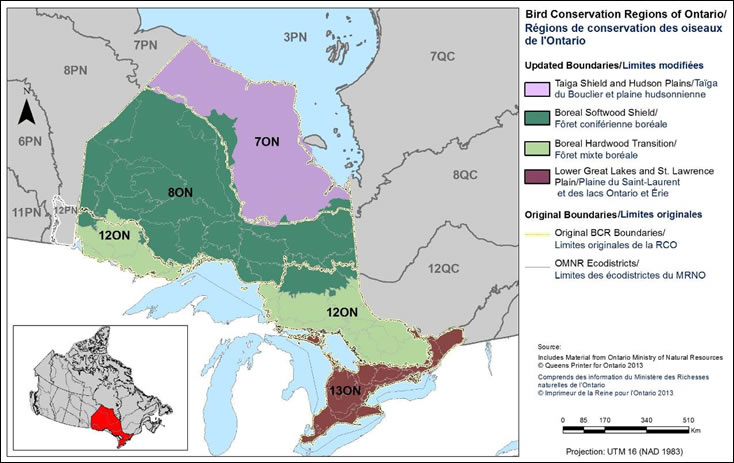
Long description for Figure 1
Map of Ontario with the Bird Conservation Regions and their updated boundaries delineated. BCR 13 ON (Lower Great Lakes / St. Lawrence Plain) covers the extreme south of the province, between lakes Huron, Erie and Ontario. The boundaries of BCR 7 ON, BCR 8 ON, BCR 12 ON and all other adjacent BCR's in Quebec and Manitoba are shown for context.
There is a bilingual legend on the right which indicates the ON BCRs (Taiga Shield and Hudson Plains/Taiga du Bouclier et plaines hudsoniennes, Boreal Softwood Shield/Forêt coniférienne boréale, Boreal Hardwood Transition/Forêt mixte boréale, Lower Great Lakes and St. Lawrence Plain/Plaine du Saint-Laurent et des lacs Ontario et Érie) and the original boundaries (Original BCR Boundaries/Limites originales de la RCO, OMNR Ecodistricts/Limites des écodistrictes du MNRO). The legend also has a visual representation of the scale of the map, it indicates the projection used (UTM 16 NAD 1983) and indicates that the source of the data is the Ontario Ministry of Natural Resources, Queen's Printer for Ontario 2013/Ministre des ressources naturelles de l'Ontario, L'imprimeur de la Reine pour l'Ontario.
For conservation planning purposes, the original Ontario BCR boundaries (as defined by the North American Bird Conservation Initiative) have been slightly modified to align with the Ontario Ministry of Natural Resources Ecodistrict boundariesFootnote7.
Figure 2. Map of habitat types in BCR 13 ON.
Note: Riparian habitat areas are not depicted on this map because they represent a “zone” and are not a true land cover/land use class. A map depicting the extent of derived riparian areas for illustration purposes can be found in the Riparian section of the complete strategy.
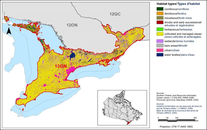
Long description for Figure 2
Map of the landcover in BCR 13 ON: Lower Great Lakes / St. Lawrence Plain. The map's extent includes southern Ontario and Quebec; the borders of adjoining BCRs are delineated.
BCR 13 ON covers the extreme south of the province, between lakes Huron, Erie and Ontario.
The various habitat types that exist in the BCR are shown on the map, and are explained in the following bilingual legend (appearing to the right of the map):
- Coniferous/conifères
- Deciduous/feuillus
- Mixedwood/forêt mixte
- Shrubs and early successional/arbustes et régénération
- Herbaceous/herbacées
- Cultivated and managed areas/zone cultivées et aménagées
- Wetlands/terres humides
- Bare areas/denude
- Urban/urbain
- Water bodies/plans d'eau
The remaining text in the legend provides the data sources for the map (i.e. Land Cover Map of Canada 2005 (CCRS, 2008), the projection of the map (i.e. UTM 9 (NAD 1983)) and there is a visual representation of the scale of the map. For BCR 13 ON, the most common habitat types are cultivated and managed, and urban.
| BCR Habitat Classa | Provincial Land Cover (PLC 27) Class(es) |
SOLRIS v1.2 Land Cover/Land Use Class(es) | Area (ha) | Percent of Total Area |
|---|---|---|---|---|
| Coniferous Forest | Forest - Dense Coniferous | Coniferous Forest Plantations - Tree Cultivation |
322,782 | 3.79% |
| Deciduous Forest | Forest - Dense Deciduous Forest - Sparse |
Deciduous Forest Forest |
730,085 | 8.59% |
| Mixed Wood Forest | Forest - Dense Mixed | Mixed Forest | 378,203 | 4.45% |
| Shrub/Early Successional | Forest Depletion - Cuts Forest Depletion - Burns Forest - Regenerating Depletion |
Tallgrass Woodland, Treed Sand Barren and Dune, > 25% vegetated Shoreline |
1,839 | 0.02% |
| Herbaceous | Agriculture -Pasture/Abandoned fields | Open Tallgrass Prairie, Tallgrass Savannah Alvar |
58,271 | 0.68% |
| Cultivated/Managed Areas | Agriculture - Cropland | Hedge Rows, Undifferentiated |
4,974,029 | 58.53% |
| Bare Areas | Sand/Gravel/Mine Tailings, Bedrock |
Open Shoreline, Open Sand Barren and Dune, Extraction, Open Cliff and Talus |
45,528 | 0.54% |
| Urban | Settlement/Infrastructure | Transportation, Built-up area pervious, Built-up area impervious |
668,898 | 7.87% |
| Wetlandsb | Marsh - Inland, Swamp - Deciduous, Swamp - Coniferous, Fen - Open, Fen - Treed, Bog - Open, Bog - Treed |
Swamp, Fen, Bog, Marsh |
1,069,538 | 12.59% |
| Waterbodiesc | Water - Deep clear, Water - Shallow/Sedimented |
Open Water | 246,932 | 2.91% |
| Ripariand | 30 m inland from shoreline | 30 m inland from shoreline | 77,614 | N/A |
| Unknown | Unknown, Cloud/shadow | Unknown, Cloud/shadow | 2,175 | 0.03% |
| - | - | Total Area: | 8,498,280 | 100% |
a BCR Habitat Classes are based on the United Nations international Land Cover Classification System (LCCS).
b Coastal wetlands are not differentiated at the resolution of Provincial Land Cover data.
c The area of waterbodies does not include the open waters of the Great Lakes. The area includes inland waterbodies only.
d Riparian areas are not included in the total area, as they are “zones” and do not represent a true provincial land cover class.
Data Source: Lower Great Lakes/St. Lawrence Plain - SOLRIS v1.2 (2000-2002 image data)
Manitoulin and North Channel Islands - Provincial Land Cover 27 (Spectranalysis Inc. 2004)
In several areas of the BCR, including Napanee, Manitoulin Island and the Carden Plain, thin soils over limestone support a sparsely vegetated habitat known as alvar, a globally rare ecosystem (Brownell and Riley 2000). In the southern extent of the region, Canada’s most southerly area, unique Carolinian forests support a high diversity of bird species including an atypically high proportion of species at risk (Ontario Partners in Flight 2008). The eastern portion of BCR 13 ON holds a unique landscape that is recognized as 1 of only 13 UNESCO World Biosphere Reserves in Canada: the Frontenac Axis (or Frontenac Arch) is a ridge of Precambrian rock that connects the Canadian Shield of the Algonquin Highlands to the Adirondack Mountains of New York. This 50 km long ridge is home to a unique assemblage of species, including highly diverse herpetofauna and uncommon birds such as the Least Bittern and Cerulean Warbler.
However, high species richness is not limited to these unique habitats. BCR 13 ON as a whole supports among the greatest diversity of breeding landbirds of any region in Canada (Rich et al. 2004) and offers important breeding habitat for a wide diversity of waterfowl, shorebirds and waterbirds. Species richness is greatest where there is a mixture of forest, wetlands and grasslands, found near the edge of the Canadian Shield in this region (Mike Cadman, pers. comm. 2012). The region is also of critical importance to birds during migration. The coastal wetlands, beaches and near-shore waters of the Great Lakes are key migratory stopovers for many waterfowl, shorebirds and waterbirds, and many landbirds congregate at locations such as Presqu’ile, Long Point and Point Pelee before continuing over the Great Lakes on their way south to complete their migration. There is also an atypically high proportion of species at risk, due in part to BCR 13 ON’s position at Canada’s most southerly latitudes, thus at the northern edge of some species’ ranges. However, it also reflects the profound influence that humans have had, and continue to have, on the landscape in this region.
The land cover of BCR 13 ON prior to European settlement bears little resemblance to that which we see today. In the early 19th century, as much as 90% of southern Ontario was covered with deciduous forest and mixed woodlands, perhaps 5% was open habitats such as natural tallgrass prairie, alvar, marsh and savannah (Larson et al. 1999), and perhaps 25% of the region was wetlands (including forested swamps; Snell 1987). Clearing of land and drainage of wetlands for agriculture was widespread and intensive, and estimates suggest a maximum loss of 94% of the region’s original upland forest (Larson et al. 1999), 97% of the native prairie and savannah habitats (Rodger 1998), and 68% of wetlands (Snell 1987) at various points in the 20th century. Although still radically different from the historic land cover, current conditions reflect a recent trend towards reforestation. In 2000, 17% of the land cover was forested, wetlands comprised 13% of the region’s area and less than 1% of the region supports natural open habitats (Figure 2, Table 1). At that time, more than half of the region’s land cover supported agriculture, and a majority of the other habitats were either human-made or managed for a variety of uses.
Not surprisingly, these massive changes in habitats in BCR 13 ON have had drastic impacts on the region’s avifauna. Grassland birds benefitted significantly from the widespread clearing of forest in the 19th century, but many have since declined due to changing land management practices, reforestation and a variety of other threats discussed in this strategy. In contrast, forest bird population show increasing population trends in the region, as evidenced by a 31% increase in counts of many but not all forest birds in the Breeding Bird Survey, 1968-1977 vs. 2001-2003, presumably in response to increases in forest cover in parts of the BCR sub-region (Ontario Partners In Flight 2008). Other trends in bird abundance, such as a decline of up to 75% in counts of migrant shorebirds at stopover sites throughout southern Ontario (Ross et al. 2012), may have little to do with habitat change in BCR 13 ON (many of the key stopovers are protected areas) and instead could relate to changing conditions on the breeding grounds or elsewhere in the non-breeding range. Still other trends in bird abundance in the region, such as a general decline in aerial insectivores, remain poorly understood (Ontario Partners In Flight 2008).
BCR 13 ON features a number of areas that are protected, including 9 National Wildlife Areas and 6 Migratory Bird Sanctuaries totalling 9,985 hectares (Protected Areas Network 2013) that are maintained by Environment and Climate Change Canada’s Canadian Wildlife Service (Figure 3). A network of national and provincial parks, provincial wildlife areas, conservation reserves, and locally managed working forests (e.g., Conservation Authority and county forests) also contributes to the conservation of birds and wildlife in the BCR. As of 2013, 48 Important Bird Areas (IBA Canada 2013) have been identified in BCR 13 ON, as well as 6 Wetlands of International Importance under the 1981 Ramsar Convention.
Figure 3. Map of protected areas BCR 13 ON.
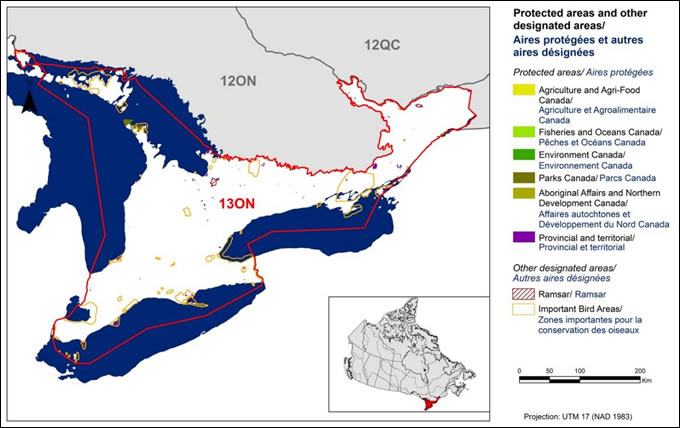
Long description for Figure 3
Map of protected and other designated areas in BCR 13 ON: Lower Great Lakes/St. Lawrence Plain. The map's extent includes southern Ontario and Quebec; the borders of adjoining BCRs are delineated. BCR 13 ON covers the extreme south of the province, between lakes Huron, Erie and Ontario.
The various types of protected areas that exist in the BCR are shown on the map, and are explained in the following bilingual legend (appearing to the right of the map):
- Protected areas/Aires protégées
- Agriculture and Agri-Food Canada/Agriculture et Agroalimentaire Canada
- Fisheries and Oceans Canada/Pêches et Océans Canada
- Environment and Climate Change Canada/Environnement et Changement climatique Canada
- Parks Canada/Parcs Canada
- Aboriginal Affairs and Northern Development Canada/Affaires autochtones et Développement du Nord Canada
- Provincial/Provincial
- Other designated areas/autres aires désignées
- Ramsar/Ramsar
- Important Bird Areas/Aires d'importance pour les oiseaux
There is also a visual representation of scale for the map in the legend and the projection of the map (i.e. UTM 9 (NAD 1983)).
There are a few small provincial and national parks, and several Important Bird Areas throughout.
Conservation efforts in BCR 13 ON must recognize that a landscape dominated by humans is the reality for this region. Despite its small size, roughly a third of the Canadian population inhabits the region, and population growth here continues to outpace that elsewhere in the province (Ontario Ministry of Finance 2010). Growth has been, and continues to be, accommodated through urban development, which has often resulted in loss of habitats and ecological functions. The ecological functions found in intact or restored migratory bird habitats, such as forests and wetlands, provide ecological goods and services to the growing human population. The economic value of these ecosystem services, from natural purification of water to control of erosion or insect pests, is increasingly recognized by both governments and the public. The concept of maintaining ecosystem services through sustainable development is widely promoted, and this increased awareness may offer new opportunities for conservation of birds and their habitats.
Approximately 90 % of all lands in Southern Ontario are privately owned (Ontario Partners In Flight 2008). Thus, implementation of conservation actions depends heavily on the involvement of private landowners. Conservation of birds on private lands, and in particular lands that are in most cases managed for a variety of human uses, is a substantial challenge involving numerous stakeholders. Yet, significant progress has been made through stewardship programs, adoption of BMPs, municipal and provincial land use plans, strategic protection of lands by environmental non-governmental organizations, the contribution of conservation authorities working with local communities, and the efforts of partnerships such as the Eastern Habitat Joint Venture. Accordingly, implementation of the actions suggested in this strategy could only be accomplished through a broad partnership of governments and stakeholders pursuing a common goal of biodiversity conservation in BCR 13 ON.