
Bird conservation strategy for region 5: Northern Pacific rainforest, chapter 7
Section 2: Conservation needs by habitat
The following sections provide more detailed information on priority species, their threats and objectives within each of the broad habitat classes that occur in BCR 5 Pacific and Yukon. Where appropriate, habitat information is provided at a finer scale than the broad habitat categories in order to coincide with other land management exercises in the region. Note that in this strategy, all areas presented below are expressed as a percentage of the terrestrial area of BCR 5 in British Columbia, unless otherwise stated. Some species do not appear in the threats table because their low level threats have not been assigned objectives or actions and/or identified threats are addressed in the Widespread Issues section of the strategy.
In this strategy, a number of priority species which once bred in or around the lower Fraser Valley and southeast Vancouver Island no longer do so; they occur only as occasional non-breeding individuals (Horned Lark (strigata), federally Endangered and provincially Red-listed; Lewis’s Woodpecker, federally Threatened and provincially Red-listed; and Western Bluebird, provincially Red-listed); or as small wintering populations (Western Meadowlark, provincially Red-listed). In this strategy we have identified threats that likely contributed to these species’ declines, and recommend actions which address these threats. While such actions may not immediately benefit these species within the BCR, they will lay the groundwork for re-establishing suitable habitat, a necessity for the success of any future reintroductions of breeding populations to be successful.
Coniferous
Coniferous forests (defined as habitat where over 75% of tree basal area is coniferous trees) are the dominant landcover of BCR 5, covering over 55% of the terrestrial area of the BCR (Martell 2005; Fig. 8). The temperate coastal forests are dominated by western redcedar, western hemlock, Douglas-fir, and Sitka spruce. At higher elevations yellow-cedar, mountain hemlock and amabilis fir occur (B.C. Ministry of Forests 1997, 1999b). Mild, wet winters allow conifers to grow year-round, and the rarity of natural stand-initiating disturbances means that individual trees can live for centuries or longer and reach massive dimensions. In BCR 5, coniferous forests are used by 31 priority species (29 landbirds and two waterbirds; Table 5). One priority species, Lewis’s Woodpecker, no longer breeds in the region and occurs only as occasional, non-breeding individuals.
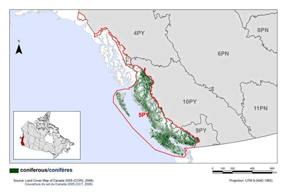
Long description for figure 8
Map of coniferous habitat in BRC 5 Pacific and Yukon Region: Northern Pacific Rainforest. The map’s extent includes British Columbia and the western portion of Alberta, along with the extreme northern portion of Washington State and the extreme southern portions of Alaska and the Yukon. The borders of BRC 4PY, 5PY, 6PN, 8PN, 9PY, 10PY and 11 PN are delineated. BRC 5 appears while the others appear differently. Inset in the lower left corner is a map of Canada with BRC 5 highlighted.
The coniferous habitat in the BRC is indicated. This habitat appears throughout the BRC, excepting in the high elevation areas, and in the extreme north of the BRC. The highest concentrations appear to be in the centre of Vancouver Island and along the coast of the lower mainland.
Beneath the map, the following bilingual legend appears: Coniferous/conifères. Source: Land Cover Map of Canada 2005 (CCRS, 2008), Couverture du sol du Canada 2005 (CCT, 2008). There is also a visual representation of scale for the map in the legend which indicates 0, 100, 200, 400 and 600 kms. The Projection is UTM 9 (NAD 1983).
The primary threat to priority species in coniferous habitats is the loss of habitat and key habitat attributes to timber harvest (Fig. 9). Habitat is also lost to urban and industrial development. Introduced and invasive species also threaten priority species via predation, competition, and habitat degradation. Key actions to address these threats include the management of timber harvest to maintain biodiversity and wildlife values, protection of key areas of coniferous forest habitat, and control or eradication of introduced species (Table 6).
| Priority species | Regional habitat sub-class | Important habitat features | Population objective | At Risk (R) | CC (R) | S (R) | NAWMP (R) |
|---|---|---|---|---|---|---|---|
| Ancient Murrelet | old growth, mature | burrows | Assess / Maintain | Yes | Yes | Yes | blank |
| Band-tailed Pigeon | mature | mineral springs, openings/clearings, fruiting understory shrubs | Increase 50% | Yes | Yes | Yes | blank |
| Chestnut-backed Chickadee | mature | cavities, snags, openings | Assess / Maintain | blank | blank | Yes | blank |
| Cooper’s Hawk | mature | cottonwood riparian, veteran trees | Increase 100% | blank | Yes | blank | blank |
| Golden-crowned Kinglet | mature, old growth | blank | Increase 100% | blank | Yes | Yes | blank |
| Hairy Woodpecker | mature, old growth | snags, openings/clearings | Assess / Maintain | blank | blank | Yes | blank |
| Hutton’s Vireo | mature, old growth | openings/clearings | Maintain current | blank | blank | Yes | blank |
| Lewis’s Woodpecker | mature, Douglas-fir | snags, recent burns, openings/clearings, low stem density | Increasea | Yes | blank | blank | blank |
| Marbled Murrelet | old growth | nest platforms | Recovery objective | Yes | Yes | Yes | blank |
| Northern Goshawk (laingi) | mature, old growth | blank | Recovery objective | Yes | blank | blank | blank |
| Northern Pygmy-Owl | mature, old growth | cavities, openings/clearings | Assess / Maintain | blank | blank | Yes | blank |
| Northern Saw-whet Owl (acadicus) | mature, old growth | cavities, openings/clearings, snags | Assess / Maintain | blank | blank | Yes | blank |
| Northern Saw-whet Owl (brooksi) | mature, old growth | cavities, openings/clearings, snags | Assess / Maintain | Yes | blank | Yes | blank |
| Olive-sided Flycatcher | mature | recent burns, openings/clearings, snags, veteran trees | Increase 100% | Yes | Yes | blank | blank |
| Pacific Wren | mature, old growth | large woody debris | Assess / Maintain | blank | blank | Yes | blank |
| Pacific-slope Flycatcher | mature, old growth | blank | Assess / Maintain | blank | blank | Yes | blank |
| Pine Grosbeak (carlottae) | mature | old burns, clearcuts, openings/clearings, fruiting understory shrubs | Assess / Maintain | Yes | blank | blank | blank |
| Pine Siskin | mature, old growth | cone crops | Increase 100% | blank | blank | Yes | blank |
| Purple Finch | mature | openings/clearings | Increase 50% | blank | Yes | blank | blank |
| Red Crossbill | mature, old growth | cone crops | Increase 50% | blank | Yes | Yes | blank |
| Red-breasted Sapsucker | mature, old growth | snags, openings/clearings | Increase 50% | blank | Yes | Yes | blank |
| Rufous Hummingbird | mature, old growth | openings/clearings | Increase 100% | blank | Yes | Yes | blank |
| Rusty Blackbird | mature, old growth | forested wetlands, bogs, openings | Assess / Maintain | Yes | Yes | blank | blank |
| Sooty Grouse | mature | openings/clearings, old burns | Increase 100% | Yes | Yes | Yes | blank |
| Spotted Owl | old growth | cavities, snags | Recovery objective | Yes | Yes | blank | blank |
| Steller’s Jay | mature, old growth | blank | Assess / Maintain | blank | blank | Yes | blank |
| Townsend’s Warbler | mature, old growth | blank | Assess / Maintain | blank | blank | Yes | blank |
| Varied Thrush | mature, old growth | fruiting understory shrubs | Assess / Maintain | blank | Yes | Yes | blank |
| Vaux’s Swift | old growth | cavities, snags, cottonwood riparian, chimneys | Assess / Maintain | blank | blank | Yes | blank |
| Western Screech-Owl (kennicotti) | mature, old growth | cavities, openings/clearings | Assess / Maintain | Yes | blank | blank | blank |
| White-tailed Ptarmigan (saxatilis) | blank | snow fields | Assess / Maintain | Yes | blank | blank | blank |
Note: Reasons for inclusion in the priority species list are as follows:
At Risk: the species is assessed as either Endangered, Threatened or Special Concern by COSEWIC or SARA, or the species is or the species is on the Red or Blue lists in B.C.; CC: the species meets conservation concern criteria for its bird group; S: the species meets stewardship criteria for its bird group; NAWMP: the species has NAWMP priority of Moderate-High, High or Highest in the BCR.
a The interim population objective is to increase the numbers of birds in the BCR, with a future goal of re-establishing a breeding population.
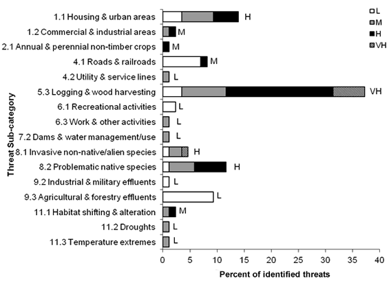
Long description for Figure 9
A horizontal bar graph indicating the percent of identified threats to priority species in coniferous habitat (x axis) in each threat sub-category (y axis) in BRC 5 Pacific and Yukon Region.
| Threat Sub-category | Low | Medium | High | Very High |
|---|---|---|---|---|
| 1.1 Housing & urban areas | 3.5 | 5.8 | 4.7 | 0.0 |
| 1.2 Commercial & industrial areas | 0.0 | 1.2 | 1.2 | 0.0 |
| 2.1 Annual & perennial non-timber crops | 0.0 | 0.0 | 1.2 | 0.0 |
| 4.1 Roads & railroads | 7.0 | 0.0 | 1.2 | 0.0 |
| 4.2 Utility & service lines | 0.0 | 1.2 | 0.0 | 0.0 |
| 5.3 Logging & wood harvesting | 3.5 | 8.1 | 19.8 | 5.8 |
| 6.1 Recreational activities | 2.3 | 0.0 | 0.0 | 0.0 |
| 6.3 Work & other activities | 0.0 | 1.2 | 0.0 | 0.0 |
| 7.2 Dams & water management/use | 0.0 | 1.2 | 0.0 | 0.0 |
| 8.1 Invasive non-native/alien species | 1.2 | 2.3 | 0.0 | 1.2 |
| 8.2 Problematic native species | 1.2 | 4.7 | 5.8 | 0.0 |
| 9.2 Industrial & military effluents | 1.2 | 0.0 | 0.0 | 0.0 |
| 9.3 Agricultural & forestry effluents | 9.3 | 0.0 | 0.0 | 0.0 |
| 11.1 Habitat shifting & alteration | 0.0 | 1.2 | 1.2 | 0.0 |
| 11.2 Droughts | 0.0 | 1.2 | 0.0 | 0.0 |
| 11.3 Temperature extremes | 0.0 | 1.2 | 0.0 | 0.0 |
Each bar represents the percent of the total number of threats identified in each threat sub-category in coniferous habitat (for example, if 100 threats were identified in total for all priority species in coniferous habitat, and 10 of those threats were in the category 1.1 Housing and urban areas, the bar on the graph would represent this as 10%). The bars are divided to show the distribution of Low (L), Medium (M), High (H) and Very High (VH) rankings of individual threats within each threat sub-category. For example, the same threat may have been ranked H for one species and L for another; the shading illustrates the proportion of L, M, H and VH rankings in the sub-category). The overall magnitude of the sub-threat in coniferous habitat is shown at the end of each bar (also presented in Table 4. Relative magnitude of identified threats to priority species within BCR 5 Pacific and Yukon by threat category and broad habitat class).
Note: Threats of all magnitudes are included, although low ranked threats affecting only a single species were not assigned conservation objectives or recommended actions. 8.1 Invasive non-native/alien species includes competition from European Starling, and effects of introduced mammals (raccoons, squirrels, rats, deer) on coastal islands. 8.2 Problematic native species includes effects of locally overabundant native deer and competition/predation by the Barred Owl. 9.3 Agricultural and forestry effluents refers to effects of pesticide use.
| Threats addressed | Threat category | Objectives | Objective category | Recommended actions | Action category | Priority species affectedb |
|---|---|---|---|---|---|---|
| Loss of coniferous habitats and changes in structural diversity due to residential development and forest management. | 1.1 Housing and urban areas 1.2 Commercial and industrial areas 2.1 Annual and perennial non-timber crops 5.3 Logging and wood harvesting |
Maintain and enhance the quality and diversity of coniferous habitats. | 1.1 Ensure land and resource-use policies and practices maintain or improve bird habitat. 1.2 Maintain the size, shape and configuration of habitat within the natural range of variation. 1.4 Maintain important habitat features on the landscape. |
Manage forests to maintain a mosaic of all habitat types and seral stages. Avoid large clearcuts and use harvest techniques such as selective cutting and variable retention that mimic natural disturbance regimes and retain important habitat features such as large veteran trees, snags, and cavity-bearing trees. Maintain structural diversity by managing for a variety of species in multi-aged stands, with well-developed shrub understory and canopy closure. Protect all remaining old-growth stands and maintain large contiguous tracts of mature trees to minimize fragmentation and edge effects. Maximize connectivity of old-growth and mature forest patches. |
1.1 Site/area protection 5.3 Private sector standards and codes |
Ancient Murrelet, Band-tailed Pigeon, Chestnut-backed Chickadee, Cooper's Hawk, Golden-crowned Kinglet, Hairy Woodpecker, Hutton's Vireo, Lewis's Woodpecker, Marbled Murrelet, Northern Goshawk (laingi), Northern Pygmy-Owl, Northern Saw-whet Owl (acadicus), Northern Saw-whet Owl (brooksi), Olive-sided Flycatcher, Pacific Wren, Pacific-slope Flycatcher, Pine Grosbeak (carlottae), Pine Siskin, Purple Finch, Red Crossbill, Red-breasted Sapsucker, Rusty Blackbird, Sooty Grouse, Spotted Owl, Steller's Jay, Townsend's Warbler, Varied Thrush, Vaux's Swift, Western Screech-Owl (kennicottii) |
| Increased “edge effect” leading to increased nest predation on Marbled Murrelet. | 5.3 Logging and wood harvesting | Maintain and enhance the quality and diversity of coniferous habitats. | 1.2 Maintain the size, shape and configuration of habitat within the natural range of variation. | Secure and manage old growth coniferous habitat for Marbled Murrelet through various methods including land acquisition, conservation easements, stewardship agreements, establishment of formal parks and protected areas, or management areas such as Wildlife Habitat Areas and Old Growth Management Areas. Avoid further fragmentation of old growth habitat used by Marbled Murrelet. This includes reducing roads and trails through these habitats. Ensure that habitat fragmentation and edge effects are considered in forest development plans. |
1.1 Site/area protection 5.3 Private sector standards and codes |
Marbled Murrelet |
| Loss of habitat to hydroelectric developments, reservoir creation and habitat fragmentation from the creation of electric transmission lines. | 4.2 Utility and service lines 7.2 Dams and water management/use |
Maintain and enhance the quality and diversity of coniferous habitats. | 1.2 Maintain the size, shape and configuration of habitat within the natural range of variation. | Secure suitable Spotted Owl habitat to compensate for habitat loss and degradation. Route future infrastructure away from areas known to be occupied by Spotted Owl. When possible, utilize pre-existing infrastructure corridors rather than creating new ones that further fragment habitat. Ensure that habitat fragmentation and resulting “edge effect” is considered in future transmission line development plans. |
2.1 Site/area management 5.2 Policies and regulations 5.3 Private sector standards and codes |
Spotted Owl |
| Harvested areas may function as ecological traps. | 5.3 Logging and wood harvesting | Maintain and enhance the quality and diversity of coniferous habitats. | 1.1 Ensure land and resource-use policies and practices maintain or improve bird habitat. | Research is needed to determine if and how clearcuts function as ecological traps for Olive-sided Flycatcher. | 8.1 Research | Olive-sided Flycatche |
| Predation of priority species by introduced predators. | 8.1 Invasive non-native/alien species | Eliminate or control invasive species while preventing future introduc-tions. | 3.5 Prevent and control the spread of invasive and exotic species. | Remove introduced predators (e.g., rats, raccoons)from all currently active and historical Ancient Murrelet colonies. Remove or control populations of introduced species which may prey upon Northern Saw-whet Owl (brooksi) nests (e.g., raccoons, red squirrels) on the Haida Gwaii archipelago. Monitor Haida Gwaii and seabird colonies for introduced or dispersing predators (including call-playback for Barred Owl on Haida Gwaii). Increase public awareness of the impacts of introduced predators to avoid future introductions. |
2.2 Invasive/pro-blematic species control 4.3 Awareness and communica-tions 8.2 Monitoring |
Ancient Murrelet, Northern Saw-whet Owl (brooksi) |
| Degradation and loss of understory vegetation caused by introduced and/or overabundant deer. Reductions in bird and rodent prey due to degradation and loss of understory vegetation caused by introduced deer in Haida Gwaii (Northern Saw-whet Owl [brooksi]). | 8.2 Problematic native species8.1 Invasive non-native/alien species | Ensure introduced and/or overabun-dant deer are not negatively impacting priority species. | 3.5 Prevent and control the spread of invasive and exotic species. 3.6 Reduce overabundant species. | Remove, reduce or control the population of introduced deer on the Haida Gwaii archipelago to maintain natural undergrowth and ground vegetation. This could be achieved in part by eliminating or increasing bag limits. In other areas where overabundant native deer are negatively impacting understory vegetation (e.g., Gulf Islands), conduct site-specific deer population control to maintain densities <0.1 deer/ha. Monitor deer density and browse intensity to identify problem areas and to evaluate the effectiveness of population control measures. | 2.2 Invasive/pro-blematic species control 2.3 Habitat and natural process restoration 5.2 Policies and regulations 8.2 Monitoring | Golden-crowned Kinglet, Hutton's Vireo, Northern Saw-whet Owl (brooksi), Pacific Wren, Pacific-slope Flycatcher, Rufous Hummingbird |
| Reduced survival of priority owl species due to Barred Owl competition and predation. Genetic swamping of the Northern Spotted Owl by Barred Owl. | 8.2 Problematic native species | Determine the impacts of Barred Owl on other owl populations as Barred Owls expand their range. | 7.4 Improve understanding of causes of population declines. | Research is required to determine Barred Owl impacts on native owl populations (such as predation rates on priority species, degree of competition for prey, and extent of interbreeding between Barred and Spotted Owls)and identify potential mitigation strategies. | 8.1 Research | Northern Pygmy-Owl, Northern Saw-whet Owl (acadicus), Northern Spotted Owl, Western Screech-Owl (kennicottii) |
| Decreased availability of nest cavities due to competition from European Starlings. | 8.1 Invasive non-native/alien species | Ensure that nest site competition is not limiting Lewis’s Woodpecker populations. | 3.1 Reduce competition with invasive species. | Conduct research to understand conditions under which nest-site competition with European Starlings can limit Lewis's Woodpecker populations, and determine if increasing European Starling populations contributed to Lewis’s Woodpecker declines in the Georgia Basin. | 5.3 Private sector standards and codes 8.1 Research | Lewis's Woodpecker |
| House Finch competing with Purple Finch for resources. | 8.2 Problematic native species | Ensure that competition is not limiting populations of priority species. | 3.2 Reduce competition with problematic native species. | Determine the ecological relationships between Purple Finch and House Finch in BCR 5. Identify the factors driving House Finch population increases and range expansion. | 8.1 Research | Purple Finch |
| Reduction in prey availability due to pesticide use. | 9.3 Agricultural and forestry effluents | Adopt integrated pest manage-ment to minimize use of pesticides. | 5.1 Maintain natural food webs and prey sources. | Avoid use of pesticides. When necessary, use only as part of an integrated pest management system to minimize destruction of non-target invertebrate and rodent species. If available, use biological control for specific noxious species, rather than chemical control. | 5.3 Private sector standards and codes | Chestnut-backed Chickadee, Hutton’s Vireo, Lewis's Woodpecker, Olive-sided Flycatcher, Vaux's Swift |
| Lowered productivity, nest abandonment and failure due to nest site disturbance from forestry operations. | 6.3 Work and other activities | Avoid disturbance of nesting raptors. | 4.2 Reduce disturbance from industrial or work activity. | Maintain a 200m undisturbed buffer around all active goshawk nest trees. Minimize disturbances near goshawk nest sites between 15 February and 1 September. | 2.1 Site/area management 5.3 Private sector standards and codes | Northern Goshawk (laingi) |
| Salmonella exposure at bird feeders | 1.1 Housing and urban areas | Reduce or eliminate disease transmission at bird feeders. | 2.6 Reduce the spread of disease. | Educate the public about the threat posed by salmonellosis and solutions to reduce disease transmission, such as regular cleaning of bird feeders and closing feeding stations when local or regional disease outbreaks occur. | 4.3 Awareness and communica-tions | Pine Siskin, Purple Finch |
b Priority species not mentioned in this table are absent for one of the following reasons: 1) no identified threats in this habitat, 2) identified threats are discussed in the Widespread Issues section, 3) identified threats in this habitat are of low magnitude.
Mixed Wood
Mixed-wood habitats (where coniferous tree basal area is less than 75% of total tree basal area) occur throughout BCR 5, typically within more extensive coniferous forest wherever disturbance or soils have allowed a substantial deciduous component to develop (Fig. 10). Fifteen (15) priority species (all landbirds) have been identified as using mixed-wood habitats (Table 7).
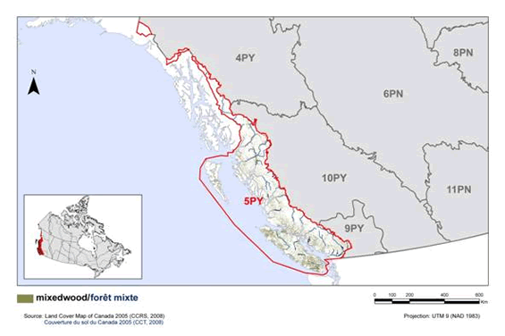
Long description for Figure 10
Map of mixed wood habitat in BRC 5 Pacific and Yukon Region: Northern Pacific Rainforest. The map’s extent includes British Columbia and the western portion of Alberta, along with the extreme northern portion of Washington State and the extreme southern portions of Alaska and the Yukon. The borders of BRC 4PY, 5PY, 6PN, 8PN, 9PY, 10PY and 11 PN are delineated. BRC 5 appears while the others appear differently. Inset in the lower left corner is a map of Canada with BRC 5 highlighted.
The mixed wood habitat in the BRC is indicated. This habitat appears in low density throughout the central and southern portions of the BRC. The highest concentrations appear to be in the north and south of Vancouver Island.
Beneath the map, the following bilingual legend appears: mixedwood/forêt mixte. Source: Land Cover Map of Canada 2005 (CCRS, 2008), Couverture du sol du Canada 2005 (CCT, 2008). There is also a visual representation of scale for the map in the legend which indicates 0, 100, 200, 400 and 600 kms. The Projection is UTM 9 (NAD 1983).
Threats to priority species in mixed wood habitats are similar to those in coniferous forest, with loss of habitat and key habitat attributes to forestry and urban/industrial development being the primary threats (Fig. 11). Competition with, and predation by, introduced and invasive species also presents risks. Key actions to address these threats include the management of timber harvest to maintain biodiversity and wildlife values, protection of key areas of habitat, and research into potentially problematic predators and competitors to quantify threats and identify potential mitigation strategies (Table 8).
| Priority species | Regional habitat sub-class | Important habitat features | Population objective | At Risk (R) | CC (R) | S (R) | NAWMP (R) |
|---|---|---|---|---|---|---|---|
| Band-tailed Pigeon | mature | mineral springs, openings/clearings, fruiting understory shrubs | Increase 50% | Yes | Yes | Yes | blank |
| Black-throated Gray Warbler | mature | blank | Assess / Maintain | blank | blank | Yes | blank |
| Bullock’s Oriole | mature | cottonwood riparian | Increase 100% | blank | Yes | blank | blank |
| Cassin’s Vireo | mature | blank | Increase 50% | blank | Yes | blank | blank |
| Chestnut-backed Chickadee | mature | cavities, snags, openings | Assess / Maintain | blank | blank | Yes | blank |
| Hairy Woodpecker | mature | snags, openings/clearings | Assess / Maintain | blank | blank | Yes | blank |
| Northern Pygmy-Owl | mature | cavities, openings/clearings | Assess / Maintain | blank | blank | Yes | blank |
| Northern Saw-whet Owl (acadicus) | mature, old growth | cavities, openings/clearings, snags | Assess / Maintain | blank | blank | Yes | blank |
| Olive-sided Flycatcher | mature | recent burns, openings/clearings, snags, veteran tree | Increase 100% | Yes | Yes | blank | blank |
| Pine Siskin | mature, old growth | cone crops | Increase 100% | blank | blank | Yes | blank |
| Purple Finch | mature | openings/clearings | Increase 50% | blank | Yes | blank | blank |
| Red-breasted Sapsucker | mature, old growth | snags, openings/clearings | Increase 50% | blank | Yes | Yes | blank |
| Steller’s Jay | mature, old growth | blank | Assess / Maintain | blank | blank | Yes | blank |
| Townsend’s Warbler | mature, old growth | blank | Assess / Maintain | blank | blank | Yes | blank |
| Western Wood-Pewee | mature | recent burns, openings/clearings | Increase 100% | blank | Yes | blank | blank |
Note: Reasons for inclusion in the priority species list are as follows:
At Risk: the species is assessed as either Endangered, Threatened or Special Concern by COSEWIC or SARA, or the species is or the species is on the Red or Blue lists in B.C.; CC: the species meets conservation concern criteria for its bird group; S: the species meets stewardship criteria for its bird group; NAWMP: the species has NAWMP priority of Moderate-High, High or Highest in the BCR.
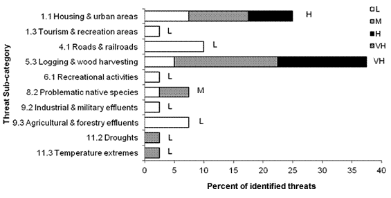
Long description for Figure 11
A horizontal bar graph indicating the percent of identified threats to priority species in mixed wood habitat (x axis) in each threat sub-category (y axis) in BRC 5 Pacific and Yukon Region.
| Threat Sub-category | Low | Medium | High | Very High |
|---|---|---|---|---|
| 1.1 Housing & urban areas | 7.5 | 10.0 | 7.5 | 0.0 |
| 1.3 Tourism & recreation areas | 2.5 | 0.0 | 0.0 | 0.0 |
| 4.1 Roads & railroads | 10.0 | 0.0 | 0.0 | 0.0 |
| 5.3 Logging & wood harvesting | 5.0 | 17.5 | 15.0 | 0.0 |
| 6.1 Recreational activities | 2.5 | 0.0 | 0.0 | 0.0 |
| 8.2 Problematic native species | 2.5 | 5.0 | 0.0 | 0.0 |
| 9.2 Industrial & military effluents | 2.5 | 0.0 | 0.0 | 0.0 |
| 9.3 Agricultural & forestry effluents | 7.5 | 0.0 | 0.0 | 0.0 |
| 11.2 Droughts | 0.0 | 2.5 | 0.0 | 0.0 |
| 11.3 Temperature extremes | 0.0 | 2.5 | 0.0 | 0.0 |
Each bar represents the percent of the total number of threats identified in each threat sub-category in mixed wood habitat (for example, if 100 threats were identified in total for all priority species in mixed wood habitat, and 10 of those threats were in the category 1.1 Housing and urban areas, the bar on the graph would represent this as 10%). The bars are divided to show the distribution of Low (L), Medium (M), High (H) and Very High (VH) rankings of individual threats within each threat sub-category. For example, the same threat may have been ranked H for one species and L for another; the shading illustrates the proportion of L, M, H and VH rankings in the sub-category). The overall magnitude of the sub-threat in mixed wood habitat is shown at the end of each bar (also presented in Table 4. Relative magnitude of identified threats to priority species within BCR 5 Pacific and Yukon by threat category and broad habitat class).
Note: Threats of all magnitudes are included, although low ranked threats affecting only a single species were not assigned conservation objectives or recommended actions. 8.2 Problematic native species includes competition with House Finch and predation by Barred Owl and Bald Eagles. 9.3 Agricultural and forestry effluents refers to pesticide use.
| Threats addressed | Threat sub-category | Objectives | Objective category | Recommended actions | Action sub-category | Priority species affectedc |
|---|---|---|---|---|---|---|
| Loss of habitat due to urban/ industrial development and logging. | 1.1 Housing and urban areas 1.2 Commercial and industrial areas 5.3 Logging and wood harvesting |
Maintain and enhance the quantity, quality and diversity of mixed woodland habitats. | 1.1 Ensure land and resource-use policies and practices maintain or improve bird habitat. 1.2 Maintain the size, shape and configuration of habitat within the natural range of variation. 1.4 Maintain important habitat features on the landscape. |
Protect key areas of mixed forest stands and maintain large contiguous tracts of mature trees through various methods including land acquisition, conservation easements, stewardship agreements or establishment of formal parks, protected areas, or management areas. Maintain key habitat features such as large veteran trees, snags, and cavity-bearing trees. Use a variety of forest management techniques to maintain a diversity of structural stages and important habitat components. |
1.1 Site/area protection 5.3 Private sector standards and codes |
Band-tailed Pigeon, Black-throated Gray Warbler, Bullock's Oriole, Cassin's Vireo, Chestnut-backed Chickadee, Hairy Woodpecker, Northern Pygmy-Owl, Northern Saw-whet Owl (acadicus), Olive-sided Flycatcher, Pine Siskin, Purple Finch, Red-breasted Sapsucker, Steller's Jay, Townsend's Warbler, Western Wood-Pewee |
| Harvested areas may function as ecological traps. | 5.3 Logging and wood harvesting | Maintain and enhance the quantity, quality and diversity of mixed woodland habitats. | 1.1 Ensure land and resource-use policies and practices maintain or improve bird habitat. | Research is needed to determine if and how clearcuts function as ecological traps for Olive-sided Flycatcher. | 8.1 Research | Olive-sided Flycatcher |
| Reduced survival of priority owl species due to Barred Owl competition and predation. | 8.2 Problematic native species | Determine the impacts of Barred Owl on other owl populations as Barred Owls expand their range. | 7.4 Improve understanding of causes of population declines. | Research is needed to determine Barred Owl impacts on native owl populations (such as predation rates on priority species and the degree of competition for prey) and identify potential mitigation strategies. | 8.1 Research | Northern Pygmy-Owl, Northern Saw-whet Owl (acadicus) |
| House Finch competing with Purple Finch for resources. | 8.2 Problematic native species | Ensure that competition is not limiting populations of priority species. | 3.2 Reduce competition with problematic native species. | Determine the ecological relationships between Purple Finch and House Finch in BCR 5. Identify the factors driving House Finch population increases and range expansion. | 8.1 Research 8.2 Monitoring | Purple Finch |
| Salmonella exposure at bird feeders. | 1.1 Housing and urban areas | Reduce or eliminate disease transmission at bird feeders. | 2.6 Reduce the spread of disease. | Educate the public about the threat posed by salmonellosis and solutions to reduce disease transmission, such as regular cleaning of bird feeders and closing feeding stations when local or regional disease outbreaks occur. | 4.3 Awareness and communications | Pine Siskin, Purple Finch |
c Priority species not mentioned in this table are absent for one of the following reasons: 1) no identified threats in this habitat, 2) identified threats are discussed in the Widespread Issues section, 3) identified threats in this habitat are of low magnitude.
Shrub and early successional
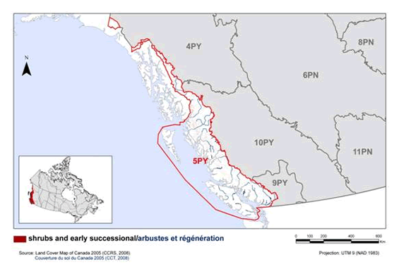
Shrub and early successional habitats are transient, occurring where disturbance (either natural or anthropogenic) has removed the tree cover and the vegetation is dominated by shrubby, early seral forms (Fig. 12). Five priority species, all landbirds, were identified as using this habitat type (Table 9).
Long description for Figure 12
Map of shrub/early successional habitat in BRC 5 Pacific and Yukon Region: Northern Pacific Rainforest. The map’s extent includes British Columbia and the western portion of Alberta, along with the extreme northern portion of Washington State and the extreme southern portions of Alaska and the Yukon. The borders of BRC 4PY, 5PY, 6PN, 8PN, 9PY, 10PY and 11 PN are delineated. BRC 5 appears while the others appear differently. Inset in the lower left corner is a map of Canada with BRC 5 highlighted.
The shrub/early successional habitat in the BRC is indicated. This habitat appears nearly absent from the BRC at this scale, with some very low density coverage in the north/central portion of the BRC.
Beneath the map, the following bilingual legend appears: shrub and early successional / arbustes et régénération. Source: Land Cover Map of Canada 2005 (CCRS, 2008), Couverture du sol du Canada 2005 (CCT, 2008). There is also a visual representation of scale for the map in the legend which indicates 0, 100, 200, 400 and 600 kms. The Projection is UTM 9 (NAD 1983).
The primary threats to priority species in this habitat type are the loss or degradation of habitat due to development or forestry activity, and degradation of habitat due to overbrowsing by deer (Fig. 13). While new patches of habitat are created by timber harvest, they are typically managed for accelerated conifer regrowth, which may reduce their suitability for various priority species (Betts et al. 2010). Key actions to address these threats include management of timber production and harvest to maintain sufficient high-quality early seral habitat on the landscape, and control of overabundant and/or introduced deer populations (Table 10).
| Priority species | Regional habitat sub-class | Important habitat features | Population objective | At Risk (R) | CC (R) | S (R) | NAWMP (R) |
|---|---|---|---|---|---|---|---|
| Common Nighthawk | early seral | recent burns, clearcuts, rocky clearings, outcrops/bluffs | Assess / Maintain | Yes | blank | blank | blank |
| MacGillivray’s Warbler | early seral | cottonwood riparian, recent burns | Increase 50% | blank | blank | Yes | blank |
| Orange-crowned Warbler | early seral | openings/clearings | Increase 100% | blank | blank | Yes | blank |
| Spotted Towhee | early seral | openings/clearings, dense shrubs | Assess / Maintain | blank | blank | Yes | blank |
| Willow Flycatcher | early seral | openings/clearings | Increase 100% | blank | Yes | Yes | blank |
Note: Reasons for inclusion in the priority species list are as follows:
At Risk: the species is assessed as either Endangered, Threatened or Special Concern by COSEWIC or SARA, or the species is or the species is on the Red or Blue lists in B.C.; CC: the species meets conservation concern criteria for its bird group; S: the species meets stewardship criteria for its bird group; NAWMP: the species has NAWMP priority of Moderate-High, High or Highest in the BCR.
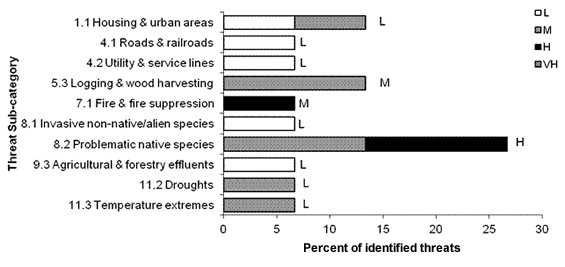
Long description for Figure 13
A horizontal bar graph indicating the percent of identified threats to priority species in shrub and early successional habitat (x axis) in each threat sub-category (y axis) in BRC 5 Pacific and Yukon Region.
| Threat Sub-category | Low | Medium | High | Very High |
|---|---|---|---|---|
| 1.1 Housing & urban areas | 6.7 | 6.7 | 0.0 | 0.0 |
| 4.1 Roads & railroads | 6.7 | 0.0 | 0.0 | 0.0 |
| 4.2 Utility & service lines | 6.7 | 0.0 | 0.0 | 0.0 |
| 5.3 Logging & wood harvesting | 0.0 | 13.3 | 0.0 | 0.0 |
| 7.1 Fire & fire suppression | 0.0 | 0.0 | 6.7 | 0.0 |
| 8.1 Invasive non-native/alien species | 6.7 | 0.0 | 0.0 | 0.0 |
| 8.2 Problematic native species | 0.0 | 13.3 | 13.3 | 0.0 |
| 9.3 Agricultural & forestry effluents | 6.7 | 0.0 | 0.0 | 0.0 |
| 11.2 Droughts | 0.0 | 6.7 | 0.0 | 0.0 |
| 11.3 Temperature extremes | 0.0 | 6.7 | 0.0 | 0.0 |
Each bar represents the percent of the total number of threats identified in each threat sub-category in shrub and early successional habitat (for example, if 100 threats were identified in total for all priority species in shrub and early successional habitat, and 10 of those threats were in the category 1.1 Housing and urban areas, the bar on the graph would represent this as 10%). The bars are divided to show the distribution of Low (L), Medium (M), High (H) and Very High (VH) rankings of individual threats within each threat sub-category. For example, the same threat may have been ranked H for one species and L for another; the shading illustrates the proportion of L, M, H and VH rankings in the sub-category). The overall magnitude of the sub-threat in shrub and early successional habitat is shown at the end of each bar (also presented in Table 4. Relative magnitude of identified threats to priority species within BCR 5 Pacific and Yukon by threat category and broad habitat class).
Note: Threats of all magnitudes are included, although low ranked threats affecting only a single species were not assigned conservation objectives or recommended actions. 8.2 Problematic native species refers primarily to effects of locally overabundant deer. 9.3 Agricultural and forestry effluents refers to effects of pesticide use.
| Threats addressed | Threat category | Objectives | Objective category | Recommended actions | Action category | Priority species affectedd |
|---|---|---|---|---|---|---|
| Loss of suitable early seral habitat due to urban development, and fire suppression. | 1.1 Housing and urban areas 7.1 Fire and fire suppression |
Maintain key habitat features in forests, including deciduous shrub layers in successional openings. | 1.2 Maintain the size, shape and configuration of habitat within the natural range of variation. 1.3 Ensure the continuation of natural processes that maintain bird habitat. |
Manage landscapes to mimic, retain or restore pre-settlement proportions and distribution of forest types, structural stages and habitat components. | 5.3 Private sector standards and codes | Common Nighthawk, Spotted Towhee, Willow Flycatcher |
| Mechanical thinning reduces deciduous cover in managed, regenerating clearcuts. | 5.3 Logging and wood harvesting | Maintain key habitat features in forests, including deciduous shrub layers in successional openings. | 1.1 Ensure land and resource-use policies and practices maintain or improve bird habitat. 1.2 Maintain the size, shape and configuration of habitat within the natural range of variation. |
Avoid large clearcuts, and use harvest techniques such as selective harvest and partial retention that mimic natural disturbance regimes. Maintain a diversity of structural stages, including early seral stages, and important habitat components, such as deciduous shrub cover, within forests. Confine mechanical control of shrubs competing with regenerating forest to the area immediately surrounding affected trees so some shrub cover is maintained for wildlife. |
5.3 Private sector standards and codes | MacGillivray's Warbler, Orange-crowned Warbler |
| Degradation and loss of understory vegetation caused by introduced and/or overabundant deer. | 8.1 Invasive non-native/alien species 8.2 Problematic native species |
Ensure introduced and/or overabundant deer are not negatively impacting priority species. | 3.6 Reduce overabundant species. | Remove, reduce or control the population of introduced deer on the Haida Gwaii archipelago to maintain natural undergrowth and ground vegetation. This could be achieved in part by eliminating or increasing bag limits. In other areas where overabundant native deer are negatively impacting understory vegetation (e.g., Gulf Islands), conduct site-specific deer population control to maintain densities <0.1 deer/ha. Monitor deer density and browse intensity to identify problem areas and to evaluate the effectiveness of population control measures. |
2.2 Invasive/prob-lematic species control 2.3 Habitat and natural process restoration 5.2 Policies and regulations 8.2 Monitoring |
MacGillivray's Warbler, Orange-crowned Warbler, Spotted Towhee, Willow Flycatcher |
d Priority species not mentioned in this table are absent for one of the following reasons: 1) no identified threats in this habitat, 2) identified threats are discussed in the Widespread Issues section, 3) identified threats in this habitat are of low magnitude.
Herbaceous
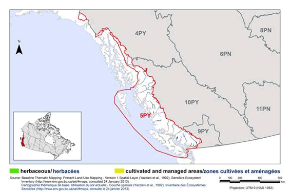
The herbaceous habitat class includes agricultural areas such as pastures and crops, artificial grasslands such as airports and parks, and natural grasslands, such as Garry Oak meadows (Fig. 14).
Agricultural lands cover approximately 0.7% of BCR 5, and are largely restricted to the low elevation plateaus and floodplains of the lower Fraser Valley and the east coast of Vancouver Island (Martell 2005). Grasslands and agricultural areas are used by 25 priority species in BCR 5 (14 landbirds, 9 waterfowl and 2 shorebirds; Table 11). Birds using grassland and agricultural areas in BCR 5 are highly threatened, as 68% of the priority species using these habitats are considered at risk, either federally or provincially. Three priority species--Horned Lark (strigata), Western Bluebird and Western Meadowlark--no longer breed in the region and occur only as occasional non-breeding individuals or small wintering populations. Primary threats to priority species in agricultural areas include loss of suitable habitat to urban/industrial development, agricultural intensification and changes to unsuitable crop types (i.e., greenhouses, berries), and exposure to pesticides (Fig. 15). Key actions to address these threats include increasing the use of beneficial management practices in agriculture to preserve biodiversity and wildlife values, minimizing use of pesticides through integrated pest management, and use of conservation covenants and other stewardship agreements to preserve key habitat types such as pastures and hayfields on the landscape (Table 12).
Long description for Figure 14
Map of herbaceous habitat in BRC 5 Pacific and Yukon Region: Northern Pacific Rainforest. The map’s extent includes British Columbia and the western portion of Alberta, along with the extreme northern portion of Washington State and the extreme southern portions of Alaska and the Yukon. The borders of BRC 4PY, 5PY, 6PN, 8PN, 9PY, 10PY and 11 PN are delineated. BRC 5 appears while the others appear differently. Inset in the lower left corner is a map of Canada with BRC 5 highlighted.
The herbaceous habitat in the BRC is indicated. This habitat type appears in moderate concentrations throughout the BRC, excepting the southern two thirds of Vancouver Island, and most of the Lower Mainland. The highest concentrations appear on the northern tip of Vancouver Island, and the northern tip of Haida Gwaii.
Beneath the map, the following bilingual legend appears: herbaceous/herbacées. Source: Land Cover Map of Canada 2005 (CCRS, 2008), Couverture du sol du Canada 2005 (CCT, 2008). There is also a visual representation of scale for the map in the legend which indicates 0, 100, 200, 400 and 600 kms. The Projection is UTM 9 (NAD 1983).
Garry Oak
Garry Oak, a unique ecosystem that occurs nowhere else in Canada, is restricted to the drier rain-shadow areas of Vancouver Island and the Gulf Islands (B.C. Ministry of Forests 1999a). Garry Oak trees form an open canopy over a diverse ground cover of grasses, wildflowers, herbs and endemic mosses. This fire-maintained system is highly imperiled. Ninety percent (90%) of the original extent of Garry Oak parkland has been lost to agriculture or urban/industrial development. For example, on Vancouver Island only 1,589 ha remains today of approximately 15,250 ha of Garry Oak present pre-European settlement. Much of what remains is highly fragmented and degraded by numerous invasive plant species; fire suppression also prevents regeneration of remaining Garry Oak habitats (Martell 2005; Lea 2006).
Five priority species, all landbirds, were identified as using Garry Oak habitats (Table 11). These priority species are not restricted solely to Garry Oak habitat, and typically occur (or occurred) more broadly throughout open forest (e.g., Cassin’s Vireo, Hutton’s Vireo) and grassland/agricultural areas (e.g., Western Bluebird) within the Georgia Basin. However Garry Oak habitats remain important to these priority bird species, and are critical to a wide diversity of plant and invertebrate species. Two of the five priority bird species that use Garry Oak habitat, Lewis’s Woodpecker and Western Bluebird, no longer breed in the region and now occur only as occasional non-breeding individuals.
The primary threats to priority species that use Garry Oak habitats include historical and current loss and degradation of habitat due to urban and industrial development, historical and current loss of nesting sites due to timber cutting, competition with invasive and introduced species, and habitat degradation and loss due to fire suppression (Fig. 15). Key actions to address these threats include the protection and restoration of remaining Garry Oak habitat, periodic burning of Garry Oak habitat to maintain native ground cover and prevent conifer encroachment, and control of invasive species (Table 12).
| Areas | Priority species | Regional habitat sub-class | Important habitat features | Population objective | At Risk (R) | CC (R) | S (R) | NAWMP (R) |
|---|---|---|---|---|---|---|---|---|
| Grassland and Agricultural Areas | American Golden-Plover | hayfield/tame pasture, row crop | blank | Migrant (no population objective) | Yes | Yes | blank | blank |
| Grassland and Agricultural Areas | American Wigeon | hayfield/tame pasture | blank | Maintain current | blank | blank | blank | Yes |
| Grassland and Agricultural Areas | Barn Owl | old field, hayfield/tame pasture | Cavities, nestboxes | Assess / Maintain | Yes | blank | blank | blank |
| Grassland and Agricultural Areas | Barn Swallow | native grassland, hayfield/tame pasture | man-made ledges, openings/clearings | Increase 100% | Yes | Yes | blank | blank |
| Grassland and Agricultural Areas | Cackling Goose | hayfield/tame pasture, row crop, old field | blank | Assess / Maintain | Yes | blank | blank | Yes |
| Grassland and Agricultural Areas | Canada Goose (Dusky) | hayfield/tame pasture, row crop, old field | blank | Assess / Maintain | Yes | blank | blank | Yes |
| Grassland and Agricultural Areas | Canada Goose (Pacific) | hayfield/tame pasture, row crop, old field | blank | Maintain current | blank | blank | blank | Yes |
| Grassland and Agricultural Areas | Common Nighthawk | old field, native grassland, hayfield/tame pasture | recent burns, clearcuts, rocky clearings, outcrops/bluffs | Assess / Maintain | Yes | blank | blank | blank |
| Grassland and Agricultural Areas | Greater White-fronted Goose | hayfield/tame pasture, row crop | blank | Assess / Maintain | blank | blank | blank | Yes |
| Grassland and Agricultural Areas | Gyrfalcon | hayfield/tame pasture | blank | Assess / Maintain | Yes | blank | blank | blank |
| Grassland and Agricultural Areas | Horned Lark (strigata) | old field, native grassland | blank | Recovery objective | Yes | blank | blank | blank |
| Grassland and Agricultural Areas | Lesser Snow Goose | hayfield/tame pasture, row crop | blank | Maintain current | blank | blank | blank | Yes |
| Grassland and Agricultural Areas | Long-billed Curlew | native grassland, hayfield/tame pasture, row crop, oldfield | blank | Recovery objective | Yes | Yes | blank | blank |
| Grassland and Agricultural Areas | Northern Harrier | old field, native grasslands | blank | Assess / Maintain | blank | Yes | blank | blank |
| Grassland and Agricultural Areas | Northern Pintail | native grassland, hayfield/tame pasture, row crop, oldfield | blank | Maintain current | blank | blank | blank | Yes |
| Grassland and Agricultural Areas | Peregrine Falcon (anatum) | hayfield, tame pasture | cliffs | Assess / Maintain | Yes | blank | blank | blank |
| Grassland and Agricultural Areas | Rough-legged Hawk | old field, native grasslands, hayfield/tame pasture | blank | Assess / Maintain | Yes | blank | blank | blank |
| Grassland and Agricultural Areas | Short-eared Owl | native grasslands, old field | blank | Assess / Maintain | Yes | blank | blank | blank |
| Grassland and Agricultural Areas | Snowy Owl | old field, native grasslands, hayfield/tame pasture | blank | Assess / Maintain | Yes | blank | blank | blank |
| Grassland and Agricultural Areas | Trumpeter Swan | row crop, hayfield/tame pasture | blank | Maintain current | blank | blank | blank | Yes |
| Grassland and Agricultural Areas | Tundra Swan | row crop, hayfield/tame pasture | blank | Assess / Maintain | Yes | blank | blank | Yes |
| Grassland and Agricultural Areas | Vesper Sparrow (affinis) | old field | blank | Recovery objective | Yes | blank | blank | blank |
| Grassland and Agricultural Areas | Violet-green Swallow | hayfield, pasture | cavities, cliffs | Assess / Maintain | blank | blank | Yes | blank |
| Grassland and Agricultural Areas | Western Bluebird | old field | cavities, snags, old burns | Increasee | Yes | Yes | blank | blank |
| Grassland and Agricultural Areas | Western Meadowlark | native grasslands, old field, hayfield/tame pasture | blank | Increasee | Yes | blank | blank | blank |
| Garry Oak | Cassin’s Vireo | Garry Oak | blank | Increase 50% | blank | Yes | blank | blank |
| Garry Oak | Hutton’s Vireo | Garry Oak | openings/clearings | Maintain current | blank | blank | Yes | blank |
| Garry Oak | Lewis’s Woodpecker | Garry Oak | snags, recent burns, openings/clearings, low stem density | Increasee | Yes | blank | blank | blank |
| Garry Oak | Western Bluebird | Garry Oak | cavities, snags, old burns | Increasee | Yes | Yes | blank | blank |
| Garry Oak | Western Wood-Pewee | Garry Oak | recent burns, openings/clearings | Increase 100% | blank | Yes | blank | blank |
Note: Reasons for inclusion in the priority species list are as follows:
At Risk: the species is assessed as either Endangered, Threatened or Special Concern by COSEWIC or SARA, or the species is or the species is on the Red or Blue lists in B.C.; CC: the species meets conservation concern criteria for its bird group; S: the species meets stewardship criteria for its bird group; NAWMP: the species has NAWMP priority of Moderate-High, High or Highest in the BCR.
e The interim population objective is to increase the numbers of birds in the BCR, with a future goal of re-establishing a breeding population.
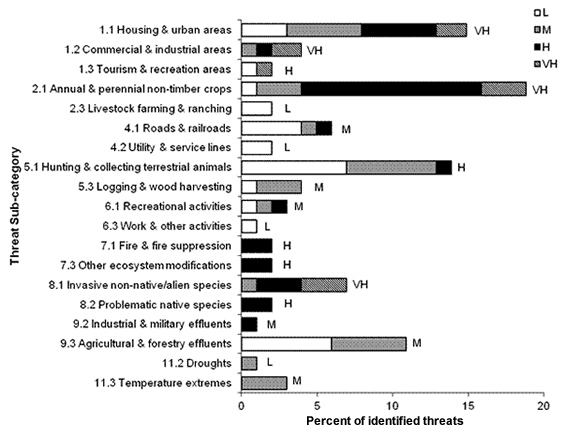
Long description for Figure 15
A horizontal bar graph indicating the percent of identified threats to priority species in herbaceous habitat (x axis) in each threat sub-category (y axis) in BRC 5 Pacific and Yukon Region.
| Threat Sub-category | Low | Medium | High | Very High |
|---|---|---|---|---|
| 1.1 Housing & urban areas | 3.0 | 5.0 | 5.0 | 2.0 |
| 1.2 Commercial & industrial areas | 0.0 | 1.0 | 1.0 | 2.0 |
| 1.3 Tourism & recreation areas | 1.0 | 0.0 | 0.0 | 1.0 |
| 2.1 Annual & perennial non-timber crops | 1.0 | 3.0 | 11.9 | 3.0 |
| 2.3 Livestock farming & ranching | 2.0 | 0.0 | 0.0 | 0.0 |
| 4.1 Roads & railroads | 4.0 | 1.0 | 1.0 | 0.0 |
| 4.2 Utility & service lines | 2.0 | 0.0 | 0.0 | 0.0 |
| 5.1 Hunting & collecting terrestrial animals | 6.9 | 5.9 | 1.0 | 0.0 |
| 5.3 Logging & wood harvesting | 1.0 | 3.0 | 0.0 | 0.0 |
| 6.1 Recreational activities | 1.0 | 1.0 | 1.0 | 0.0 |
| 6.3 Work & other activities | 1.0 | 0.0 | 0.0 | 0.0 |
| 7.1 Fire & fire suppression | 0.0 | 0.0 | 2.0 | 0.0 |
| 7.3 Other ecosystem modifications | 0.0 | 0.0 | 2.0 | 0.0 |
| 8.1 Invasive non-native/alien species | 0.0 | 1.0 | 3.0 | 3.0 |
| 8.2 Problematic native species | 0.0 | 0.0 | 2.0 | 0.0 |
| 9.2 Industrial & military effluents | 0.0 | 0.0 | 1.0 | 0.0 |
| 9.3 Agricultural & forestry effluents | 5.9 | 5.0 | 0.0 | 0.0 |
| 11.2 Droughts | 0.0 | 1.0 | 0.0 | 0.0 |
| 11.3 Temperature extremes | 0.0 | 3.0 | 0.0 | 0.0 |
Each bar represents the percent of the total number of threats identified in each threat sub-category in herbaceous habitat (for example, if 100 threats were identified in total for all priority species in herbaceous habitat, and 10 of those threats were in the category 1.1 Housing and urban areas, the bar on the graph would represent this as 10%). The bars are divided to show the distribution of Low (L), Medium (M), High (H) and Very High (VH) rankings of individual threats within each threat sub-category. For example, the same threat may have been ranked H for one species and L for another; the shading illustrates the proportion of L, M, H and VH rankings in the sub-category). The overall magnitude of the sub-threat in herbaceous habitat is shown at the end of each bar (also presented in Table 4. Relative magnitude of identified threats to priority species within BCR 5 Pacific and Yukon by threat category and broad habitat class).
Note: Threats of all magnitudes are included, although low ranked threats affecting only a single species were not assigned conservation objectives or recommended actions. 5.1 Hunting and collecting terrestrial animals refers primarily to lead poisoning of waterfowl from ingestion of lead shot, but also includes hunting and illegal harvest. 8.1 Invasive non-native/alien species and 8.2 Problematic native species includes predation by domestic cats and competition with native and introduced species (House Wren, House Sparrow, European Starling) for nesting cavities. 9.3 Agricultural and forestry effluents refers to effects of pesticide use.
| Areas | Threats addressed | Threat category | Objectives | Objective category | Recommended actions | Action category | Priority species affectedf |
|---|---|---|---|---|---|---|---|
| Grasslands and Agricultural Areas | Loss of grassland and agricultural habitat to urban, industrial and recreational development. Loss of suitable crop types to agricultural intensification (e.g., berry crops, greenhouses). |
1.1 Housing and urban areas 1.2 Commercial and industrial areas 1.3 Tourism and recreation areas 2.1 Annual and perennial non-timber crops, 2.3 Livestock farming and ranching |
Maintain the quantity, quality and diversity of herbaceous habitats. | 1.1 Ensure land and resource-use policies and practices maintain or improve bird habitat. 1.2 Maintain the size, shape and configuration of habitat within the natural range of variation. |
Identify, protect and manage agricultural habitat for priority species through various methods including land acquisition, conservation easements, stewardship agreements or establishment of formal parks or management areas. Secure and protect any remaining natural grassland habitat. Manage agricultural areas to maintain pasture and old field habitats. Maintain key features such as hedgerows, timber stands and snags. |
1.1 Site/area protection 2.1 Site/area management 5.3 Private sector standards and codes |
American Golden-Plover, American Wigeon, Barn Owl, Barn Swallow, Common Nighthawk, Horned Lark (strigata), Lesser Snow Goose, Long-billed Curlew, Northern Pintail, Rough-legged Hawk, Short-eared Owl, Trumpeter Swan, Tundra Swan, Vesper Sparrow (affinis), Western Bluebird, Western Meadowlark |
| Grasslands and Agricultural Areas | Reduction in prey availability due to pesticide use. | 9.3 Agricultural and forestry effluents | Adopt integrated pest management to minimize use of pesticides. | 5.1 Maintain natural food webs and prey sources. | Avoid use of pesticides. When necessary, use only as part of an integrated pest management system to minimize destruction of non-target invertebrate and rodent species. If available, use biological control for specific noxious species, rather than chemical control. |
5.3 Private sector standards and codes | Barn Swallow, Common Nighthawk, Northern Harrier, Violet-green Swallow |
| Grasslands and Agricultural Areas | Habitat degradation by introduced species. | 8.1 Invasive non-native/alien species | Eliminate or control invasive species while preventing future introductions. | 3.5 Prevent and control the spread of invasive and exotic species. | Eliminate or control introduced plant species occurring in estuaries and beach/dune habitat. Increase public awareness of invasive plant species and measures to control their spread (such as regular cleaning of vehicles and equipment, and using only native species for gardening, landscaping and re-vegetation purposes), to prevent establishment of additional invasive species. |
2.2 Invasive/prob-lematic species control 4.3 Awareness and communications |
Horned Lark (strigata) |
| Grasslands and Agricultural Areas | Decreased availability of nest cavities due to competition from European Starlings, House Sparrows, and House Wrens. | 8.1 Invasive non-native/alien species | Ensure that nest site competition is not limiting populations of priority species. | 3.1 Reduce competition with invasive species. | Retain all cavity-bearing trees and snags as nesting habitat. In areas where cavities are limiting, consider initiating a long-term, well-managed nest-box program. To reduce exclusion by House Wrens, nest boxes will need annual maintenance and monitoring. Annual nest box cleaning should occur before March. Reduce and control European Starling and House Sparrow populations. This can be achieved in part by designing new structures and retrofitting existing structures to exclude nesting sites for these species. |
2.2 Invasive/ problematic species control 2.3 Habitat and natural process restoration 3.2 Species recovery |
Violet-green Swallow, Western Bluebird |
| Grasslands and Agricultural Areas | Disturbance from recreational activities at roosting, foraging and nesting areas. | 6.1 Recreational activities | Avoid disturbance of priority species and prevent changes in habitat use due to disturbance. | 4.1 Reduce disturbance from human recreation. | Increase public awareness of target groups of the impacts of human disturbance on priority species, and methods to minimize such disturbance. Consider establishment of seasonal buffer zones or closures around key areas used by Trumpeter Swans. For Vesper Sparrow, implement public education and stewardship initiatives in areas containing critical habitat or potential critical habitat for this species. |
2.1 Site/area management 4.3 Awareness and communications |
Trumpeter Swan, Vesper Sparrow (affinis) |
| Grasslands and Agricultural Areas | Human disturbance at or development near Peregrine Falcon nest sites may lead to nest abandonment. | 6.1 Recreational activities 6.3 Work and other activities |
Avoid disturbance of nesting raptors. | 4.1 Reduce disturbance from human recreation. 4.2 Reduce disturbance from industrial or work activity. |
Maintain an undisturbed, naturally vegetated buffer of at least 50 m (urban), 200 m (rural) or 500 m (undeveloped areas) from the base of Peregrine Falcon nesting cliffs or around other Peregrine Falcon nest sites. Raise public awareness of raptors and their habitat and nesting needs. Continue to enforce British Columbia's Wildlife Act regulations around disturbance at Peregrine Falcon nests. |
2.1 Site/area management 5.4 Compliance and enforcement |
Peregrine Falcon (anatum) |
| Grasslands and Agricultural Areas | Mortality from hunting. | 5.1 Hunting and collecting terrestrial animals | Manage hunting mortality to maintain game bird populations. | 7.2 Improve harvest monitoring. | Continue to enforce legal bag and possession limits. Where possible, use adaptive management to ensure viable population levels. Promote increased hunter skill in waterfowl identification (avoid Cackling Goose or Dusky Canada Goose being mistaken for Pacific Canada Goose). |
3.1 Species management 4.2 Training communications 5.4 Compliance and enforcement |
Cackling Goose, Canada Goose (Dusky) |
| Grasslands and Agricultural Areas | Nests destroyed by haying, mowing and harvesting practices. | 2.1 Annual and perennial non-timber crops 2.3 Livestock farming and ranching |
Prevent destruction of bird nests, in accordance with federal and provincial legislation. | 2.9 Reduce nest destruction. | Avoid use of heavy equipment in fields supporting breeding grassland birds during the breeding season. Delay spring mowing of hayfields until mid or late July. To minimize risk of affecting any late nesters, mow or plough from the center of the field outwards and slow equipment if birds are flushed to give adults and flightless/newly fledged young time to escape. |
2.1 Site/area management 5.3 Private sector standards and codes |
Northern Harrier, Short-eared Owl, Vesper Sparrow (affinis), Western Meadowlark |
| Grasslands and Agricultural Areas | Removal of nests by landowners. Loss of nesting sites (building modification, building removal). |
5.1 Hunting and collecting terrestrial animals 7.3 Other ecosystem modifications |
Prevent destruction of bird nests, in accordance with the Migratory Birds Convention Act. | 1.4 Maintain important habitat features on the landscape. 2.9 Reduce nest destruction. |
Research is needed to quantify the distribution and intensity of nest removal and assess the threat this behaviour poses to Barn Swallow populations. Increase public awareness of the species, its benefits, and current legal protection to increase stewardship and eliminate destruction of nests. Encourage landowners to incorporate nesting ledges on out-buildings in habitat suitable for Barn Swallows. |
4.3 Awareness and communications 5.4 Compliance and enforcement 8. 1 Research |
Barn Swallow |
| Grasslands and Agricultural Areas | Loss of Barn Owl nesting sites due to modernization of buildings. | 7.3 Other ecosystem modifications | Ensure that suitable nest sites are not limiting Barn Owl populations. | 1.4 Maintain important habitat features on the landscape. | Increase public awareness of the Barn Owl and encourage landowners to install nest boxes when renovating, removing old, or building new farm out-buildings in habitat suitable for Barn Owls. Encourage and support well planned nest box projects and monitoring programs. |
3.2 Species recovery 4.3 Awareness and communications |
Barn Owl |
| Garry Oak | Loss of habitat to current and historical development, agricultural conversion and timber harvest. | 1.1 Housing and urban areas 1.2 Commercial and industrial areas 2.1 Annual and perennial non-timber crops, 2.3 Livestock farming and ranching 5.3 Logging and wood harvesting |
Maintain the quantity, quality and diversity of Garry Oak habitat. | 1.2 Maintain the size, shape and configuration of habitat within the natural range of variation. 1.4 Maintain important habitat features on the landscape. |
Protect, maintain and restore all remaining Garry Oak habitat. Maintain all cavity-bearing trees and snags, and prevent the cutting or removal of Garry Oaks. |
1.1 Site/area protection 2.3 Habitat and natural process restoration 5.2 Policies and regulations |
Cassin's Vireo, Hutton's Vireo, Lewis's Woodpecker, Western Bluebird, Western Wood-Pewee |
| Garry Oak | Forest encroachment due to fire suppression. | 7.1 Fire and fire suppression | Maintain the quantity, quality and diversity of Garry Oak habitat. | 1.3 Ensure the continuation of natural processes that maintain bird habitat. | Wherever possible, mimic historical fire regimes with controlled, low intensity burns outside of the breeding season to maintain fire-dependant Garry Oak habitats. | 2.3 Habitat and natural process restoration | Western Bluebird, Lewis's Woodpecker |
| Garry Oak | Reduction in prey availability due to pesticide use. | 9.3 Agricultural and forestry effluents | Adopt integrated pest management to minimize use of pesticides. | 5.1 Maintain natural food webs and prey sources. | Avoid use of pesticides. When necessary, use only as part of an integrated pest management system to minimize destruction of non-target invertebrate and rodent species. If available, use biological control for specific noxious species, rather than chemical control. |
5.3 Private sector standards and codes | Hutton's Vireo, Lewis's Woodpecker |
| Garry Oak | Decreased availability of nest cavities due to competition from European Starlings, House Sparrows, and House Wrens. | 8.1 Invasive non-native/alien species 8.2 Problematic native species |
Ensure that nest site competition is not limiting Lewis's Woodpecker and Western Bluebird populations. | 3.1 Reduce competition with invasive species. | Retain all cavity-bearing trees and snags as nesting habitat. In areas where cavities are limiting, consider initiating a long-term, well-managed nest-box program. To reduce exclusion by House Wrens, nest boxes will need annual maintenance and monitoring. Annual nest box cleaning should occur before March. Reduce and control European Starling and House Sparrow populations. This can be achieved in part by designing new structures and retrofitting existing structures to exclude nesting sites for these species. |
2.2 Invasive/prob-lematic species control 2.3 Habitat and natural process restoration 3.2 Species recovery |
Lewis's Woodpecker, Western Bluebird |
f Priority species not mentioned in this table are absent for one of the following reasons: 1) no identified threats in this habitat, 2) identified threats are discussed in the Widespread Issues section, 3) identified threats in this habitat are of low magnitude.
Urban
The urban habitat class consists of urban, suburban and industrial areas where developments such as buildings, roads, parking lots and other impervious surfaces are common (Fig. 16). Urban areas cover 1.1% of the terrestrial area of BCR 5 (Martell 2005). BCR 5 contains Vancouver, which is Canada’s third-largest urban area in terms of population size (population 2,117,000 as of 2006; Statistics Canada 2008). The majority of British Columbia’s population (over 3 million; Statistics Canada 2008) lives in or near Vancouver, Victoria, and the east coast of Vancouver Island. Only four priority species were identified as using urban habitats in BCR 5: Barn Owl, Barn Swallow, Cooper’s Hawk, and Northwestern Crow (Table 13).
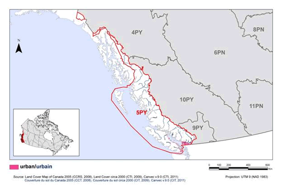
Long description for Figure 16
Map of urban habitat in BRC 5 Pacific and Yukon Region: Northern Pacific Rainforest. The map’s extent includes British Columbia and the western portion of Alberta, along with the extreme northern portion of Washington State and the extreme southern portions of Alaska and the Yukon. The borders of BRC 4PY, 5PY, 6PN, 8PN, 9PY, 10PY and 11 PN are delineated. BRC 5 appears while the others appear differently. Inset in the lower left corner is a map of Canada with BRC 5 highlighted.
The urban habitat in the BRC is indicated in pink. This habitat is mostly restricted to the Lower Mainland and the east coast of Vancouver Island.
Beneath the map, the following bilingual legend appears: urban/urbain [pink]. Source: Land Cover Map of Canada 2005 (CCRS, 2008), Couverture du sol du Canada 2005 (CCT, 2008). There is also a visual representation of scale for the map in the legend which indicates 0, 100, 200, 400 and 600 kms. The Projection is UTM 9 (NAD 1983).
Primary threats to priority species in urban habitats include loss of foraging habitat and nesting sites due to continuing development, loss of prey and secondary poisoning from pesticide use, and mortality due to collisions with vehicles and buildings (Fig. 17). No threats were identified for the Northwestern Crow. Key actions to address these threats include managing landscapes to provide habitat for Cooper’s Hawks and Barn Owls, increasing public awareness of Barn Swallows to reduce persecution, and reducing use of pesticides. Conservation objectives and recommended actions relating to collision mortality and pesticide poisoning are presented separately in the Widespread Issues section (Table 14).
| Priority species | Regional habitat sub-class | Important habitat features | Population objective | At Risk (R) | CC (R) | S (R) | NAWMP (R) |
|---|---|---|---|---|---|---|---|
| Barn Owl | - | cavities, nest boxes | Assess / Maintain | Yes | blank | blank | blank |
| Barn Swallow | - | man-made ledges, openings/clearings | Increase 100% | Yes | Yes | blank | blank |
| Cooper’s Hawk | - | cottonwood riparian, veteran trees | Increase 100% | blank | Yes | blank | blank |
| Northwestern Crow | - | blank | Assess / Maintain | blank | blank | Yes | blank |
Note: Reasons for inclusion in the priority species list are as follows:
At Risk: the species is assessed as either Endangered, Threatened or Special Concern by COSEWIC or SARA, or the species is or the species is on the Red or Blue lists in B.C.; CC: the species meets conservation concern criteria for its bird group; S: the species meets stewardship criteria for its bird group; NAWMP: the species has NAWMP priority of Moderate-High, High or Highest in the BCR.
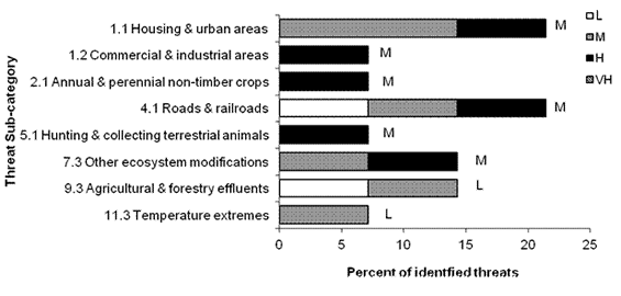
Long description for Figure 17
A horizontal bar graph indicating the percent of identified threats to priority species in urban habitat (x axis) in each threat sub-category (y axis) in BRC 5 Pacific and Yukon Region.
| Threat Sub-category | Low | Medium | High | Very High |
|---|---|---|---|---|
| 1.1 Housing & urban areas | 0.0 | 14.3 | 7.1 | 0.0 |
| 1.2 Commercial & industrial areas | 0.0 | 0.0 | 7.1 | 0.0 |
| 2.1 Annual & perennial non-timber crops | 0.0 | 0.0 | 7.1 | 0.0 |
| 4.1 Roads & railroads | 7.1 | 7.1 | 7.1 | 0.0 |
| 5.1 Hunting & collecting terrestrial animals | 0.0 | 0.0 | 7.1 | 0.0 |
| 7.3 Other ecosystem modifications | 0.0 | 7.1 | 7.1 | 0.0 |
| 9.3 Agricultural & forestry effluents | 7.1 | 7.1 | 0.0 | 0.0 |
| 11.3 Temperature extremes | 0.0 | 7.1 | 0.0 | 0.0 |
Each bar represents the percent of the total number of threats identified in each threat sub-category in urban habitat (for example, if 100 threats were identified in total for all priority species in urban habitat, and 10 of those threats were in the category 1.1 Housing and urban areas, the bar on the graph would represent this as 10%). The bars are divided to show the distribution of Low (L), Medium (M), High (H) and Very High (VH) rankings of individual threats within each threat sub-category. For example, the same threat may have been ranked H for one species and L for another; the shading illustrates the proportion of L, M, H and VH rankings in the sub-category). The overall magnitude of the sub-threat in urban habitat is shown at the end of each bar (also presented in Table 4).
Note: Threats of all magnitudes are included, although low ranked threats affecting only a single species were not assigned conservation objectives or recommended actions. 5.1 Hunting and collecting terrestrial animals refers to removal of nests from buildings, and 7.3 Other ecosystem modifications refers to loss of nesting sites.
| Threats addressed | Threat category | Objective | Objective category | Recommended actions | Action category | Priority species affectedg |
|---|---|---|---|---|---|---|
| Loss of foraging habitat to urban, industrial and agricultural conversion. Loss of Barn Owl nesting sites due to modernization of buildings. |
1.1 Housing and urban areas 1.2 Commercial and industrial areas 7.3 Other ecosystem modifications |
Protect, maintain and enhance high quality nesting and foraging habitat for Barn Owls. | 1.4 Maintain important habitat features on the landscape. | Determine the amount of foraging area needed to sustain nesting Barn Owls in urban areas. Identify, protect and manage critical foraging sites for Barn Owls though various methods including land acquisition, conservation easements, stewardship agreements or establishment of formal parks or management areas. Increase public awareness of the Barn Owl and encourage landowners to install nest boxes when renovating, removing old, or building new farm out-buildings in habitat suitable for Barn Owls. Encourage and support well planned nest box projects and monitoring programs. |
1.1 Site/area protection 3.2 Species recovery 4.3 Awareness and communications 8.1 Research |
Barn Owl |
| Loss of nesting/roosting/perching trees to development. | 1.1 Housing and urban areas | Maintain required habitat features for urban raptors. | 1.4 Maintain important habitat features on the landscape. | Retain all trees used or suspected of being used as nesting sites by raptors. Maintain stands of deciduous and coniferous trees with interlocking canopy in woodlots, greenbelts, riparian corridors, and parks/recreation areas, particularly large trees. Manage these areas to ensure a future supply of nesting trees. Raise public awareness of raptors and their habitat and nesting needs, and encourage landowners to retain trees as raptor habitat. |
2.1 Site/area management 4.3 Awareness and communications |
Cooper’s Hawk |
| Removal of Barn Swallow nests by landowners. Loss of nesting sites (building modification, building removal). |
5.1 Hunting and collecting terrestrial animals 7.3 Other ecosystem modifications |
Prevent destruction of bird nests, in accordance with the Migratory Birds Convention Act. | 1.4 Maintain important habitat features on the landscape. | Research is needed to quantify the distribution and intensity of nest removal and assess the threat this behaviour poses to Barn Swallow populations. Increase public awareness of the species, its benefits, and current legal protection to increase stewardship and eliminate destruction of nests. Encourage landowners to incorporate nesting ledges on out-buildings in habitat suitable for Barn Swallows. |
8.1 Research 4.3 Awareness and communications 5.4 Compliance and enforcement |
Barn Swallow |
| Reduction in prey availability due to pesticide use. | 9.3 Agricultural and forestry effluents | Adopt integrated pest management to minimize use of pesticides. | 5.1 Maintain natural food webs and prey sources. | Avoid use of pesticides. When necessary, use only as part of an integrated pest management system to minimize destruction of non-target invertebrate species. If available, use biological control for specific noxious species, rather than chemical control. |
5.3 Private sector standards and codes | Barn Swallow |
g Priority species not mentioned in this table are absent for one of the following reasons: 1) no identified threats in this habitat, 2) identified threats are discussed in the Widespread Issues section, 3) identified threats in this habitat are of low magnitude.
Wetland
The wetland habitat class includes bogs, swamps, marshes, fens, and shallow open water (largely non-vegetated surface, but < 2 m deep; Fig. 18). These areas cover about 1.5% of BCR 5 (Martell 2005). However, their small extent belies their importance, as wetlands are extremely diverse and productive habitats. Fourteen (14) priority species (6 waterbirds, 5 waterfowl, and 3 landbirds) were identified as using wetland habitats in BCR 5 (Table 15).
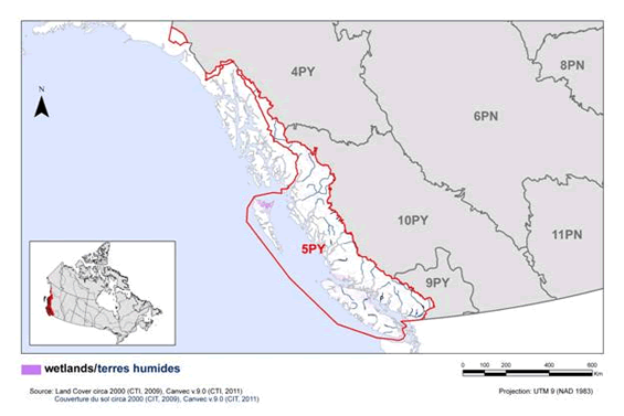
Long description for Figure 18
Map of coniferous habitat in BRC 5 Pacific and Yukon Region: Northern Pacific Rainforest. The map's extent includes British Columbia and the western portion of Alberta, along with the extreme northern portion of Washington State and the extreme southern portions of Alaska and the Yukon. The borders of BRC 4PY, 5PY, 6PN, 8PN, 9PY, 10PY and 11 PN are delineated. BRC 5 appears while the others appear differently. Inset in the lower left corner is a map of Canada with BRC 5 highlighted.
The coniferous habitat in the BRC is indicated. This habitat appears throughout the BRC, excepting in the high elevation areas, and in the extreme north of the BRC. The highest concentrations appear to be in the centre of Vancouver Island and along the coast of the lower mainland.
Beneath the map, the following bilingual legend appears: Coniferous/conifères. Source: Land Cover Map of Canada 2005 (CCRS, 2008), Couverture du sol du Canada 2005 (CCT, 2008). There is also a visual representation of scale for the map in the legend which indicates 0, 100, 200, 400 and 600 kms. The Projection is UTM 9 (NAD 1983).
Large quantities of wetland habitat have been lost in the past due to drainage or filling for agriculture or urban and industrial development. Agriculture, urban development and forestry can also negatively impact remaining wetlands by altering local hydrology. Pressures have been particularly intense in the lower Fraser Valley. For example, approximately 80% of the wetlands in the Greater Vancouver Regional District had been lost to agriculture or urban development by 1930, and gradual losses continue today (Eriksson et al. 2009). Species using wetland habitat are threatened by historical and ongoing loss of habitat to urban/industrial development and agricultural conversion, and eutrophication of wetlands (Fig. 19). Some species are also threatened by exposure to environmental contaminants such as pesticides and lead. Key actions to address these threats include avoiding further loss of wetland habitat to development, and increasing the use of beneficial management practices for biodiversity and bird conservation in agriculture, including the use of integrated pest management to minimize use of pesticides and establishment and maintenance of suitable vegetated buffers to maintain water quality (Table 16).
| Priority species | Regional habitat sub-class | Important habitat features | Population objective | At Risk (R) | CC (R) | S (R) | NAWMP (R) |
|---|---|---|---|---|---|---|---|
| American Bittern | marsh, swamp | blank | Assess / Maintain | Yes | blank | blank | blank |
| Black Tern | marsh | blank | Increase 50% | blank | Yes | Yes | blank |
| Black-crowned Night-Heron | marsh | blank | Assess / Maintain | Yes | blank | Yes | blank |
| Blue-winged Teal | marsh | sheltered shoreline | Assess / Maintain | blank | blank | blank | Yes |
| Cinnamon Teal | marsh | blank | Assess / Maintain | blank | blank | blank | Yes |
| Great Blue Heron (fannini) | marsh | sheltered shoreline, cottonwood riparian, veteran trees | Assess / Maintain | Yes | blank | blank | blank |
| Green Heron | marsh, swamp | blank | Assess / Maintain | Yes | blank | blank | blank |
| Green-winged Teal | marsh | blank | Assess / Maintain | blank | blank | blank | Yes |
| Mallard | marsh | blank | Assess / Maintain | blank | blank | blank | Yes |
| Northern Harrier | marsh | blank | Assess / Maintain | blank | Yes | blank | blank |
| Northern Shoveler | marsh | sheltered shoreline | Assess / Maintain | blank | blank | blank | Yes |
| Rough-legged Hawk | marsh | blank | Assess / Maintain | Yes | blank | blank | blank |
| Rusty Blackbird | marsh, bog, fen, swamp | forested wetlands, bogs, openings | Assess / Maintain | Yes | Yes | blank | blank |
| Wilson's Phalarope | marsh | blank | Migrant (no population objective) | blank | Yes | blank | blank |
Note: Reasons for inclusion in the priority species list are as follows:
At Risk: the species is assessed as either Endangered, Threatened or Special Concern by COSEWIC or SARA, or the species is or the species is on the Red or Blue lists in B.C.; CC: the species meets conservation concern criteria for its bird group; S: the species meets stewardship criteria for its bird group; NAWMP: the species has NAWMP priority of Moderate-High, High or Highest in the BCR.
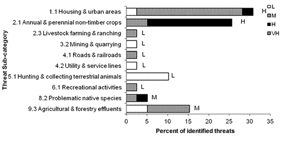
Long description for Figure 19
A horizontal bar graph indicating the percent of dentified threats to priority species in wetland habitat (x axis) in each threat sub-category (y axis) in BRC 5 Pacific and Yukon Region.
| Threat Sub-category | Low | Medium | High | Very High |
|---|---|---|---|---|
| 1.1 Housing & urban areas | 2.6 | 25.6 | 2.6 | 0.0 |
| 2.1 Annual & perennial non-timber crops | 0.0 | 5.1 | 20.5 | 0.0 |
| 2.3 Livestock farming & ranching | 0.0 | 2.6 | 0.0 | 0.0 |
| 3.2 Mining & quarrying | 2.6 | 0.0 | 0.0 | 0.0 |
| 4.1 Roads & railroads | 0.0 | 2.6 | 0.0 | 0.0 |
| 4.2 Utility & service lines | 2.6 | 0.0 | 0.0 | 0.0 |
| 5.1 Hunting & collecting terrestrial animals | 10.3 | 0.0 | 0.0 | 0.0 |
| 6.1 Recreational activities | 0.0 | 2.6 | 0.0 | 0.0 |
| 8.2 Problematic native species | 0.0 | 2.6 | 2.6 | 0.0 |
| 9.3 Agricultural & forestry effluents | 5.1 | 10.3 | 0.0 | 0.0 |
Each bar represents the percent of the total number of threats identified in each threat sub-category in wetland habitat (for example, if 100 threats were identified in total for all priority species in wetland habitat, and 10 of those threats were in the category 1.1 Housing and urban areas, the bar on the graph would represent this as 10%). The bars are divided to show the distribution of Low (L), Medium (M), High (H) and Very High (VH) rankings of individual threats within each threat sub-category. For example, the same threat may have been ranked H for one species and L for another; the shading illustrates the proportion of L, M, H and VH rankings in the sub-category). The overall magnitude of the sub-threat in wetland habitat is shown at the end of each bar (also presented in Table 4. Relative magnitude of identified threats to priority species within BCR 5 Pacific and Yukon by threat category and broad habitat class).
Note: Threats of all magnitudes are included, although low ranked threats affecting only a single species were not assigned conservation objectives or recommended actions. 5.1 Hunting and collecting terrestrial animals refers to lead poisoning of waterfowl due to ingestion of lead shot, 8.2 Problematic native species refers to competition with Red-winged Blackbird and predation by Bald Eagles, and 9.3 Agricultural and forestry effluents includes wetland eutrophication and effects of pesticide use.
| Threats addressed | Threat category | Objective | Objective category | Recommended actions | Action category | Priority species affectedh |
|---|---|---|---|---|---|---|
| Wetland loss due to urban development and agricultural intensification. | 1.1 Housing and urban areas 2.1 Annual and perennial non-timber crops |
Maintain and enhance the quantity and diversity of wetland habitats, in support of the Federal Policy on Wetland Conservation. | 1.1 Ensure land and resource-use policies and practices maintain or improve bird habitat. | Secure and manage wetlands for priority birds through various methods including land acquisition, conservation easements, stewardship agreements or establishment of formal parks, protected areas, or management areas. | 1.1 Site/area protection | American Bittern, Black Tern, Blue-winged Teal, Cinnamon Teal, Great Blue Heron (fannini), Green Heron, Green-winged Teal, Mallard, Northern Shoveler, Rough-legged Hawk, Wilson’s Phalarope |
| Degradation of wetlands due to agriculture and livestock activity. | 2.1 Annual and perennial non-timber crops 2.3 Livestock farming and ranching |
Maintain and enhance the quantity and diversity of wetland habitats, in support of the Federal Policy on Wetland Conservation. | 1.1 Ensure land and resource-use policies and practices maintain or improve bird habitat. | Maintain/restore suitable riparian buffers around wetlands to reduce erosion and runoff, and provide foraging and nesting habitat for birds. Avoid grazing near wetlands during the breeding season. |
2.1 Site/area management 2.3 Habitat and natural process restoration 5.3 Private sector standards and codes |
American Bittern, Black Tern, Blue-winged Teal, Cinnamon Teal, Green Heron, Green-winged Teal, Mallard, Northern Harrier, Northern Shoveler, Rough-legged Hawk |
| Eutrophication of wetlands. | 9.3 Agricultural and forestry effluents | Maintain and enhance the quantity and diversity of wetland habitats, in support of the Federal Policy on Wetland Conservation. | 1.5 Reduce habitat degradation from contaminants. | Maintain unfertilized buffer areas around wetlands and riparian areas. Manage runoff to avoid contamination of surface water by silage, manure or fertilizer. Use fertilizer application practices that reduce the risk of direct drift into water courses or indirect drift into runoff flows that enter aquatic habitats. |
2.1 Site/area management 5.3 Private sector standards and codes |
American Bittern, Black Tern |
| Loss of nesting habitat due to urban development. | 1.1 Housing and urban areas | Ensure that nesting habitat availability is not limiting Great Blue Heron (fannini) populations. | 1.4 Maintain important habitat features on the landscape. | Within the Fraser Valley, maintain woodlots with mature trees within 3 km of suitable heron foraging habitat. Establish visual barriers (e.g., tall vegetation) and reduced-activity buffer zones around heron nesting areas to prevent disturbance. | 2.1 Site/area management | Great Blue Heron (fannini) |
| Forestry practices encourage spread of Red-winged Blackbird into Rusty Blackbird habitat. | 8.2 Problematic native species | Ensure that competition is not limiting Rusty Blackbird populations. | 3.2 Reduce competition with problematic native species. | Research is required to determine if competition with Red-winged Blackbirds is limiting Rusty Blackbird populations and identify possible mitigation measures. In the interim, maintain unharvested buffers of contiguous forest around bogs used by breeding Rusty Blackbird. |
2.1 Site/area management 8.1 Research |
Rusty Blackbird |
| Predation on nesting Great Blue Heron (fannini) by Bald Eagles. | 8.2 Problematic native species | Determine if Bald Eagle predation is negatively impacting Great Blue Heron populations. | 7.1 Improve population/ demographic monitoring. |
Research is required to determine if anthropogenic factors are increasing nest predation on Great Blue Herons by Bald Eagles, assess the degree of threat to herons from this predation, and identify potential mitigation strategies. | 8.1 Research | Great Blue Heron (fannini) |
| Human disturbance at nesting colonies may lead to reduced productivity or colony abandonment. | 6.1 Recreational activities | Avoid human disturbance of nesting priority species. | 4.1 Reduce disturbance from human recreation. | Limit access to active colonies through creation of buffer zones, seasonal trail closures and limiting events. Increase public awareness of the impacts of human disturbance on priority species, and methods to minimize such disturbance. |
2.1 Site/area management 4.3 Awareness and communica-tions 5.2 Policies and regulations |
Great Blue Heron (fannini) |
h Priority species not mentioned in this table are absent for one of the following reasons: 1) no identified threats in this habitat, 2) identified threats are discussed in the Widespread Issues section, 3) identified threats in this habitat are of low magnitude.
Waterbodies, snow and ice
Freshwater
The waterbodies, snow and ice habitat class includes standing and flowing water such as reservoirs, lakes, ponds, rivers and streams, as well as areas where snow and/or ice covers the ground for the majority of the year (Fig. 20). Permanent snow and ice are not considered bird habitat per se in BCR 5, so the following section focuses on reservoirs, lakes, ponds, streams and rivers.
Freshwater waterbodies cover approximately 2% of BCR 5 (Martell 2005). Ten (10) priority species were identified as using freshwater habitat, including 3 landbirds, 3 waterbirds and 4 waterfowl (Table 17).
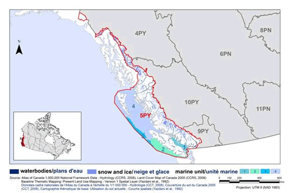
Long description for Figure 20
Map of waterbodies, snow and ice habitat in BRC 5 Pacific and Yukon Region: Northern Pacific Rainforest. The map’s extent includes British Columbia and the western portion of Alberta, along with the extreme northern portion of Washington State and the extreme southern portions of Alaska and the Yukon. The borders of BRC 4PY, 5PY, 6PN, 8PN, 9PY, 10PY and 11 PN are delineated. BRC 5 appears while the others appear differently. Inset in the lower left corner is a map of Canada with BRC 5 highlighted.
The waterbodies, snow and ice habitat in the BRC is indicated. This habitat appears throughout the BRC on what are obviously mountain tops, mostly along the eastern border of the BRC. Large rivers are also indicated throughout the BRC.
Beneath the map, the following bilingual legend appears: waterbodies/plans d’eau snow and ice/neige et glace. Source: Land Cover Map of Canada 2005 (CCRS, 2008), Couverture du sol du Canada 2005 (CCT, 2008). There is also a visual representation of scale for the map in the legend which indicates 0, 100, 200, 400 and 600 kms. The Projection is UTM 9 (NAD 1983).
Primary threats to priority species using freshwater habitats include loss and degradation of habitat due to urban and industrial development, changes in hydrology and water quality due to large-scale timber harvest and hydroelectric development, and exposure to environmental contaminants such as pesticides and lead. Human disturbance also reduces habitat suitability (Fig. 21). Key actions to address these threats include the establishment and maintenance of naturally-vegetated buffers around waterbodies to maintain wildlife habitat, management of timber harvest and associated activities to avoid runoff, and the careful siting and management of hydroelectric developments to maintain natural hydrological regimes (Table 18). Creation of restricted-access buffer zones around key areas and increasing public awareness of the effects of human disturbance on birds would also be beneficial. Objectives and recommended actions to address environmental contaminants (pesticides, PCBs, lead, other heavy metals, etc.) are presented separately in the Widespread Issues section.
| Priority species | Regional habitat sub-class |
Important habitat features | Population objective | At Risk (R) | CC (R) | S (R) | NAWMP (R) |
|---|---|---|---|---|---|---|---|
| Bald Eagle | lake, river | veteran trees | Assess / Maintain | blank | blank | Yes | blank |
| Belted Kingfisher | lake, river | burrows | Assess / Maintain | blank | blank | Yes | blank |
| Black Swift | stream, river | waterfalls, cliffs/canyons | Increase 100% | blank | Yes | Yes | blank |
| Black-crowned Night-Heron | lake, pond | blank | Assess / Maintain | Yes | blank | Yes | blank |
| Canvasback | pond, lake | blank | Assess / Maintain | blank | blank | blank | Yes |
| Common Loon | lake | blank | Assess / Maintain | blank | blank | Yes | blank |
| Greater Scaup | lake, pond | blank | Increase | blank | blank | blank | Yes |
| Green Heron | lake, river, pond | blank | Assess / Maintain | Yes | blank | blank | blank |
| Harlequin Duck | stream, river | exposed and sheltered (rocky) shorelines | Assess / Maintain | blank | blank | blank | Yes |
| Lesser Scaup | lake, pond | blank | Increase | blank | blank | blank | Yes |
Note: Reasons for inclusion in the priority species list are as follows:
At Risk: the species is assessed as either Endangered, Threatened or Special Concern by COSEWIC or SARA, or the species is or the species is on the Red or Blue lists in B.C.; CC: the species meets conservation concern criteria for its bird group; S: the species meets stewardship criteria for its bird group; NAWMP: the species has NAWMP priority of Moderate-High, High or Highest in the BCR.
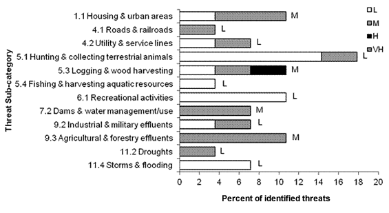
Long description for Figure 21
A horizontal bar graph indicating the percent of identified threats to priority species in freshwater habitat (x axis) in each threat sub-category (y axis) in BRC 5 Pacific and Yukon Region.
| Threat Sub-category | Low | Medium | High | Very High |
|---|---|---|---|---|
| 1.1 Housing & urban areas | 3.6 | 7.1 | 0.0 | 0.0 |
| 4.1 Roads & railroads | 0.0 | 3.6 | 0.0 | 0.0 |
| 4.2 Utility & service lines | 3.6 | 3.6 | 0.0 | 0.0 |
| 5.1 Hunting & collecting terrestrial animals | 14.3 | 3.6 | 0.0 | 0.0 |
| 5.3 Logging & wood harvesting | 3.6 | 3.6 | 3.6 | 0.0 |
| 5.4 Fishing & harvesting aquatic resources | 3.6 | 0.0 | 0.0 | 0.0 |
| 6.1 Recreational activities | 10.7 | 0.0 | 0.0 | 0.0 |
| 7.2 Dams & water management/use | 0.0 | 7.1 | 0.0 | 0.0 |
| 9.2 Industrial & military effluents | 3.6 | 3.6 | 0.0 | 0.0 |
| 9.3 Agricultural & forestry effluents | 0.0 | 10.7 | 0.0 | 0.0 |
| 11.2 Droughts | 0.0 | 3.6 | 0.0 | 0.0 |
| 11.4 Storms & flooding | 7.1 | 0.0 | 0.0 | 0.0 |
Each bar represents the percent of the total number of threats identified in each threat sub-category in freshwater habitat (for example, if 100 threats were identified in total for all priority species in freshwater habitat, and 10 of those threats were in the category 1.1 Housing and urban areas, the bar on the graph would represent this as 10%). The bars are divided to show the distribution of Low (L), Medium (M), High (H) and Very High (VH) rankings of individual threats within each threat sub-category. For example, the same threat may have been ranked H for one species and L for another; the shading illustrates the proportion of L, M, H and VH rankings in the sub-category). The overall magnitude of the sub-threat in freshwater habitat is shown at the end of each bar (also presented in Table 4. Relative magnitude of identified threats to priority species within BCR 5 Pacific and Yukon by threat category and broad habitat class).
Note: Threats of all magnitudes are included, although low ranked threats affecting only a single species were not assigned conservation objectives or recommended actions. 5.1 Hunting and collecting terrestrial animals includes hunting mortality and poisoning from lead shot. 5.4 Fishing and harvesting aquatic resources refers to lead poisoning from sinkers/jigs. 9.2 Industrial and military effluents refers to heavy metals and PCBs. 9.3 Agricultural and forestry effluents refers to pesticides.
| Threats addressed | Threat category | Objective | Objective category | Recommended actions | Action category | Priority species affectedi |
|---|---|---|---|---|---|---|
| Loss of lake/pond habitat and associated emergent vegetation due to urban development. | 1.1 Housing and urban areas | Maintain the quantity, quality and diversity of lakes, ponds, and associated riparian habitats. | 1.1 Ensure land and resource-use policies and practices maintain or improve bird habitat. | Avoid draining waterbodies of any size. Maintain undisturbed and undeveloped buffer zones around waterbodies of all types (minimum 30 m in urban areas, 100 m in rural areas and 150 m in undeveloped areas). Retain natural vegetation in these buffer zones. Maintain natural shoreline vegetation and emergent vegetation in the water, and minimize water access points. |
1.2 Resource and habitat protection 2.1 Site/area management 5.3 Private sector standards and codes |
Canvasback, Common Loon |
| Loss of perching, roosting and nesting habitat to urban development. | 1.1 Housing and urban areas | Maintain the quantity, quality and diversity of lakes, ponds, and associated riparian habitats. | 1.4 Maintain important habitat features on the landscape. | In suburban and urban areas, maintain existing large veteran trees within or near riparian areas to provide perching, roosting and nesting habitat for Bald Eagles. Protect all trees that are being used or are suspected of being used by nesting Bald Eagles. | 1.2 Resource and habitat protection 2.1 Site/area management |
Bald Eagle |
| Habitat loss due to increased siltation and removal of riparian vegetation during logging. | 5.3 Logging and wood harvesting | Maintain the quantity, quality and diversity of streams, rivers, and associated riparian habitats. | 1.1 Ensure land and resource-use policies and practices maintain or improve bird habitat. | In watersheds suitable for Harlequin Ducks, follow Beneficial management practices to minimize runoff, including routing roads through upland areas rather than through streamside zones and wet areas. Install and maintain appropriate erosion control measures to avoid runoff into watercourses. Retain natural riparian vegetation in buffer strips (>30 m wide) on either side of the watercourse. Retain riparian and upland vegetation in >300 m wide buffer strips along at least 10% of stream length to maintain wildlife habitat. Employ British Columbia's Riparian Areas Regulation for fish habitat where applicable. |
5.3 Private sector standards and codes 5.4 Compliance and enforcement |
Harlequin Duck |
| Loss of breeding habitat to hydroelectric development. | 7.2 Dams and water management/use | Maintain natural hydrologic regimes. | 1.3 Ensure the continuation of natural processes that maintain bird habitat. | In watersheds suitable for Harlequin Ducks, maintain the natural range of variation in water flow, water levels and flood frequency in rivers and streams. On controlled streams, mimic historical hydrological regimes as closely as possible. At a minimum, maintain recommended instream flow thresholds. Conduct research to determine the impacts of altered streamflow on nesting density and success of Harlequin Ducks. |
1.2 Resource and habitat protection 5.3 Private sector standards and codes 8.1 Research |
Harlequin Duck |
| Altered hydrologic regimes due to large-scale timber harvest or hydroelectric developments reduce the suitability of waterfall nesting sites. | 5.3 Logging and wood harvesting 7.2 Dams and water management/use |
Maintain natural hydrologic regimes. | 1.3 Ensure the continuation of natural processes that maintain bird habitat. | Conduct inventories of Black Swift nest sites in BCR 5. Develop and implement monitoring programs to determine population trends. Locate hydroelectric developments to minimize reduction of flow at waterfalls. Manage timber harvest to ensure that natural hydrological cycles are maintained at known Black Swift nest sites. Initiate research to determine the impacts of altered streamflow on nesting density and success of Black Swift. |
5.2 Policies and regulations 8.1 Research 8.2 Monitoring |
Black Swift |
| Human disturbance at foraging and nesting areas. | 6.1 Recreational activities | Avoid human disturbance of priority species and prevent changes in habitat use due to disturbance. | 4.1 Reduce disturbance from human recreation. | Ensure commercial tourism operators are following backcountry tourism/commercial recreation wildlife guidelines and encourage members of the public to do so as well. Use a combination of buffer zones and seasonal closures around key breeding and foraging areas to prevent disturbance of birds. Reduce or avoid activities such as rafting, boating or fishing on stream reaches used by breeding Harlequin Ducks, particularly narrower streams. Increase public awareness of the impacts of human disturbance on priority species, and methods to minimize such disturbance. |
2.1 Site/area management 4.3 Awareness and communications 5.3 Private sector standards and codes |
Common Loon, Green Heron, Harlequin Duck |
i Priority species not mentioned in this table are absent for one of the following reasons: 1) no identified threats in this habitat, 2) identified threats are discussed in the Widespread Issues section, 3) identified threats in this habitat are of low magnitude.
Marine
The waterbodies, snow and ice habitat class also includes oceanic habitats. BCR 5 encompasses the Pacific Ocean out to the limit of Canada’s exclusive economic zone, and this marine area is represented by the Strait of Georgia, Southern Shelf, Northern Shelf and Offshore Pacific Marine Biogeographic Units. Marine habitats in BCR 5 range from nearshore habitats to pelagic waters beyond the continental shelf. Nearshore conditions vary from the low productivity of the northern fjords to the highly productive Vancouver Island shelf and Strait of Georgia. Offshore areas also include areas of high productivity around upwellings near the continental self break. Both nearshore and offshore habitats are important for commercial fishing and include major transportation corridors for British Columbia’s busy shipping industry (Martell 2005). Very little (0.5%) of Canada’s Pacific ocean is currently protected, and most of the existing protected area is shallow waters adjacent to the coast (B.C. Ministry of the Environment 2006). Forty-two priority species (33 waterbirds, 7 waterfowl, and 1 shorebird) were identified as using marine habitats in BCR 5 (Table 19). Twenty-three of these (56%) are considered at risk, either provincially or federally.
Major threats to priority species in Canada’s Pacific Ocean include oil spills, potential impacts of commercial fisheries on the availability of prey, entanglement in fishing gear, ingestion of plastic debris, and changes in productivity and altered oceanic food webs due to climate change (Fig. 22). Key actions to address these threats include the use of avian bycatch mitigation measures in longline and gillnet fisheries, research to determine the effects of commercial fisheries on seabirds and consideration for marine birds in fisheries management, and reducing the amount of plastic waste in the marine environment (Table 20). Further information on the expected effects of climate change in BCR 5 can be found in the Widespread Issues section, as well as objectives and actions associated with oil spills and climate change.
| Priority species | Regional habitat sub-class | Important habitat features | Population objective | At Risk (R) | CC (R) | S (R) | NAWMP (R) |
|---|---|---|---|---|---|---|---|
| Ancient Murrelet | continental shelf waters, pelagic waters | burrows | Assess / Maintain | Yes | Yes | Yes | blank |
| Barrow’s Goldeneye | nearshore waters | cavities | Maintain current | blank | blank | blank | Yes |
| Black Scoter | nearshore waters | shellfish beds | Increase | blank | blank | blank | Yes |
| Black-footed Albatross | continental shelf waters, pelagic waters | blank | Assess / Maintain | Yes | Yes | Yes | blank |
| Brandt’s Cormorant | nearshore waters | kelp | Assess / Maintain | Yes | Yes | Yes | blank |
| Bufflehead | nearshore waters | cavities | Maintain current | blank | blank | blank | Yes |
| Buller’s Shearwater | continental shelf waters, pelagic waters | blank | Assess / Maintain | Yes | blank | blank | blank |
| California Gull | nearshore waters, continental shelf waters and pelagic waters | exposed and sheltered (rocky) shoreline | Assess / Maintain | Yes | blank | Yes | blank |
| Caspian Tern | nearshore waters | blank | Assess / Maintain | Yes | blank | blank | blank |
| Cassin’s Auklet | continental shelf waters, pelagic waters | burrows | Assess / Maintain | Yes | blank | Yes | blank |
| Common Goldeneye | nearshore waters | cavities | Assess / Maintain | blank | blank | blank | Yes |
| Common Loon | nearshore waters, continental shelf waters | blank | Assess / Maintain | blank | blank | Yes | blank |
| Common Murre | nearshore waters, continental shelf waters, pelagic waters | cliffs, rock outcrops | Assess / Maintain | Yes | blank | Yes | blank |
| Common Tern | nearshore waters | kelp | Migrant (no population objective) | blank | blank | Yes | blank |
| Double-crested Cormorant | nearshore waters | rock outcrops | Assess / Maintain | Yes | blank | blank | blank |
| Flesh-footed Shearwater | continental shelf waters, pelagic waters | blank | Assess / Maintain | Yes | blank | blank | blank |
| Glaucous-winged Gull | nearshore waters, continental shelf waters | rock outcrops | Assess / Maintain | blank | blank | Yes | blank |
| Greater Scaup | nearshore waters | blank | Increase | blank | blank | blank | Yes |
| Heermann's Gull | nearshore waters, continental shelf waters | kelp | Assess / Maintain | blank | blank | Yes | blank |
| Horned Grebe | nearshore waters | blank | Assess / Maintain | Yes | blank | blank | blank |
| Horned Puffin | continental shelf waters, pelagic waters | cliffs | Assess / Maintain | Yes | Yes | Yes | blank |
| Laysan Albatross | continental shelf waters, pelagic waters | blank | Assess / Maintain | Yes | Yes | Yes | blank |
| Leach's Storm-Petrel | pelagic waters | burrows | Assess / Maintain | blank | Yes | blank | blank |
| Lesser Scaup | nearshore waters | blank | Increase | blank | blank | blank | Yes |
| Manx Shearwater | nearshore waters, continental shelf waters, pelagic waters | blank | Assess / Maintain | blank | Yes | Yes | blank |
| Marbled Murrelet | nearshore waters, continental shelf waters, pelagic waters | blank | Recovery objective | Yes | Yes | Yes | blank |
| Northern Fulmar | continental shelf waters, pelagic waters | cliffs | Assess / Maintain | Yes | blank | blank | blank |
| Pelagic Cormorant | nearshore waters | cliffs | Assess / Maintain | blank | Yes | Yes | blank |
| Pigeon Guillemot | nearshore waters, continental shelf waters | burrows | Assess / Maintain | blank | blank | Yes | blank |
| Pink-footed Shearwater | continental shelf waters, pelagic waters | blank | Recovery objective | Yes | Yes | blank | blank |
| Red-necked Phalarope | nearshore, continental shelf waters, pelagic waters | kelp | Assess / Maintain | Yes | blank | blank | blank |
| Rhinoceros Auklet | continental shelf waters, pelagic waters | burrows | Assess / Maintain | blank | blank | Yes | blank |
| Short-tailed Albatross | continental shelf waters, pelagic waters | blank | Recovery objective | Yes | Yes | blank | blank |
| Surf Scoter | nearshore waters | shellfish beds | Increase | Yes | blank | blank | Yes |
| Thayer's Gull | nearshore waters, and continental shelf waters | blank | Assess / Maintain | blank | blank | Yes | blank |
| Thick-billed Murre | nearshore waters, continental shelf waters, pelagic waters | cliffs, rock outcrops | Assess / Maintain | Yes | blank | Yes | blank |
| Tufted Puffin | continental shelf waters, pelagic waters | burrows | Assess / Maintain | Yes | blank | Yes | blank |
| Western Grebe | nearshore waters | blank | Increase 100% | Yes | blank | Yes | blank |
| Western Gull | nearshore waters, continental shelf waters | blank | Assess / Maintain | blank | blank | Yes | blank |
| White-winged Scoter | nearshore waters | blank | Increase | blank | blank | blank | Yes |
| Xantus's Murrelet | continental shelf waters, pelagic waters | blank | Assess / Maintain | blank | Yes | Yes | blank |
| Yellow-billed Loon | nearshore waters, continental shelf waters | sheltered waters | Assess / Maintain | Yes | blank | blank | blank |
Note: Reasons for inclusion in the priority species list are as follows. At Risk: the species is assessed as either Endangered, Threatened or Special Concern by COSEWIC, or the species is on the Red or Blue lists in B.C.; CC: the species meets conservation concern criteria for its bird group; S: the species meets stewardship criteria for its bird group; NAWMP: the species has NAWMP priority of Moderate-High, High or Highest in the BCR.
Long description for Figure 22
A horizontal bar graph indicating the percent of identified threats to priority species in marine habitat (x axis) in each threat sub-category (y axis) in BRC 5 Pacific and Yukon Region.
| Threat Sub-category | Low | Medium | High | Very High |
|---|---|---|---|---|
| 1.2 Commercial & industrial areas | 0.6 | 0.0 | 0.0 | 0.0 |
| 5.4 Fishing & harvesting aquatic resources | 6.1 | 22.4 | 1.8 | 0.0 |
| 6.1 Recreational activities | 1.2 | 0.6 | 0.0 | 0.0 |
| 9.2 Industrial & military effluents | 21.2 | 14.5 | 1.8 | 0.0 |
| 9.3 Agricultural & forestry effluents | 1.2 | 1.8 | 0.6 | 0.0 |
| 9.4 Garbage & solid waste | 3.0 | 10.9 | 0.0 | 0.0 |
| 11.1 Habitat shifting & alteration | 0.0 | 0.6 | 9.1 | 0.0 |
| 11.4 Storms & flooding | 0.0 | 0.0 | 2.4 | 0.0 |
Each bar represents the percent of the total number of threats identified in each threat sub-category in marine habitat (for example, if 100 threats were identified in total for all priority species in marine habitat, and 10 of those threats were in the category 1.1 Housing and urban areas, the bar on the graph would represent this as 10%). The bars are divided to show the distribution of Low (L), Medium (M), High (H) and Very High (VH) rankings of individual threats within each threat sub-category. For example, the same threat may have been ranked H for one species and L for another; the shading illustrates the proportion of L, M, H and VH rankings in the sub-category). The overall magnitude of the sub-threat in marine habitat is shown at the end of each bar (also presented in Table 4. Relative magnitude of identified threats to priority species within BCR5 Pacific and Yukon by threat category and broad habitat class).
Note: The overall rolled-up magnitude of the threat is shown at the end of each bar. Threats of all magnitudes are included, although low ranked threats affecting only a single species were not assigned conservation objectives or recommended actions. 5.4 Fishing and harvesting aquatic resources refers primarily to fisheries bycatch and effects of commercial fisheries on prey stocks. 9.2 Industrial and military effluents includes oil spills and contaminants such as heavy metals and PCBs. 9.3 Agricultural and forestry effluents refers to pesticides, and 9.4 Garbage and solid waste refers to ingestion of plastic debris.
| Threats addressed | Threat category | Objective | Objective category | Recommended actions | Action category | Priority species affectedj |
|---|---|---|---|---|---|---|
| Mortality due to entanglement in gillnets. | 5.4 Fishing and harvesting aquatic resources | Eliminate accidental bird mortality in gillnet fisheries, in accordance with the Migratory Birds Convention Act. | 2.4 Reduce incidental mortality. | Implement bycatch mitigation measures such as visual net panels and spatial and temporal management of net deployment. Encourage collection and removal of derelict fishing gear. Monitor and assess the effectiveness of mitigation measures for each fishery. Research and develop fishery-specific mitigation measures. |
5.2 Policies and regulations 5.3 Private sector standards and codes 8.1 Research 8.2 Monitoring |
Ancient Murrelet, Brandt's Cormorant, California Gull, Cassin's Auklet, Common Murre, Double-crested Cormorant, Horned Grebe, Horned Puffin, Manx Shearwater, Marbled Murrelet, Pelagic Cormorant, Pigeon Guillemot, Rhinoceros Auklet, Surf Scoter, Thayer's Gull, Thick-billed Murre, Tufted Puffin, Western Grebe, Western Gull, Xantus's Murrelet |
| Mortality due to entanglement in longlines. | 5.4 Fishing and harvesting aquatic resources | Eliminate accidental bird mortality in longline fisheries, in accordance with the Migratory Birds Convention Act. | 2.4 Reduce incidental mortality. | Implement, monitor and enforce bycatch mitigation measures such as increasing bait sink rates and installing bird scaring devices such as lines, streamers and curtains. Monitor and assess the effectiveness of mitigation measures for each fishery. Research and develop fishery specific mitigation measures. |
5.2 Policies and regulations 5.3 Private sector standards and codes 8.1 Research 8.2 Monitoring |
Black-footed Albatross, California Gull, Glaucous-winged Gull , Laysan Albatross, Northern Fulmar, Pink-footed Shearwater, Short-tailed Albatross |
| Ingestion of plastic waste by priority species. | 9.4 Garbage and solid waste | Reduce the amount of plastic waste available for ingestion in marine environments. | 2.2 Reduce mortality and/or sub-lethal effects from exposure to contaminants. | Determine the extent and impact of plastic ingestion on adult survival and reproductive success. Monitor levels of plastic pollution in the environment and determine sources. Support compliance with international laws (such as MARPOL Annex 5)banning the dumping of garbage at sea. Encourage and support education programs that reduce plastic waste in marine environments. Encourage and support the adoption of “Zero Waste” strategies by municipal, provincial, national and international governments. |
4.3 Awareness and communications 5.2 Policies and regulations 5.4 Compliance and enforcement 8.1 Research 8.2 Monitoring |
Ancient Murrelet, Black-footed Albatross, Buller's Shearwater, California Gull, Cassin's Auklet, Common Murre, Flesh-footed Shearwater, Glaucous-winged Gull, Heermann's Gull, Horned Puffin, Laysan Albatross, Leach's Storm-Petrel, Manx Shearwater, Northern Fulmar, Pigeon Guillemot, Pink-footed Shearwater, Red-necked Phalarope, Rhinoceros Auklet, Short-tailed Albatross, Thayer's Gull, Thick-billed Murre, Tufted Puffin, Western Gull |
| Commercial fisheries may reduce prey stocks. | 5.4 Fishing and harvesting aquatic resources | Ensure that competition with commercial fisheries is not limiting populations of priority bird species. | 5.3 Reduce human competition for food resources or foraging sites. | Research is required to determine if direct or indirect competition with commercial fisheries for prey is limiting seabird species. Determine the degree of overlap between commercial fisheries and the foraging needs of priority bird species. Include consideration of marine birds in the management of commercial fisheries. |
5.2 Policies and regulations 5.3 Private sector standards and codes 8.1 Research |
Black-footed Albatross, Brandt's Cormorant, Buller's Shearwater, Caspian Tern, Common Loon, Common Murre, Double-crested Cormorant, Flesh-footed Shearwater, Horned Puffin, Laysan Albatross, Manx Shearwater, Marbled Murrelet, Northern Fulmar, Pelagic Cormorant, Pigeon Guillemot, Pink-footed Shearwater, Rhinoceros Auklet, Short-tailed Albatross, Thick-billed Murre, Tufted Puffin, Western Grebe, Xantus's Murrelet, Yellow-billed Loon |
| Human disturbance at roosting and foraging areas. | 6.1 Recrea-tional activities | Avoid human disturbance of priority species and prevent changes in habitat use due to disturbance. | 4.1 Reduce disturbance from human recreation. | Ensure commercial tourism operators are following backcountry tourism/commercial recreation wildlife guidelines and encourage members of the public to do so as well. Increase public awareness of the impacts of human disturbance on priority species, and methods to minimize such disturbance. |
4.3 Awareness and communications 5.3 Private sector standards and codes |
Ancient Murrelet, Lesser Scaup, Marbled Murrelet |
j Priority species not mentioned in this table are absent for one of the following reasons: 1) no identified threats in this habitat, 2) identified threats are discussed in the Widespread Issues section, 3) identified threats in this habitat are of low magnitude.
Coastal
BCR 5 includes all 29,000 km of British Columbia’s coastline (Fig. 23). In BCR 5, the coastal habitat class encompasses a wide variety of shoreline habitats, from steep, rugged cliffs and exposed rocky islands to sandy beaches, estuaries, saltmarshes, and mudflats. BCR 5’s many remote islands and seaside cliffs provide nesting habitat for over 5 million seabirds at approximately 500 sites (Martell 2005), and rocky shorelines and coastal waters are used by a wide variety of shorebirds, waterbirds and seaducks. While BCR 5’s shoreline is dominated by steep rocky shores and deep fjords, there are also over 440 estuaries, occupying about 2.3% of BCR 5’s coastline (Austin et al. 2008). These estuaries provide important habitat for many waterfowl, waterbirds and shorebirds. Mudflats, sand flats, beaches and dunes provide critical stopover habitat for millions of migrating shorebirds, particularly the Fraser River estuary, which is a site of hemispheric importance under the Western Hemisphere Shorebird Reserve Network, an Important Bird Area, and contains a Ramsar site. The diversity of coastal habitats and their importance to birds in BCR 5 is reflected in the fact that almost half of all priority species in BCR 5 (68 of 139, or 49%; Table 21) use coastal habitat, including landbirds (11 species), waterbirds (22), shorebirds (17) and waterfowl (18). Thirty of these (44%) are considered at risk, either federally or provincially. One species, the Horned Lark (strigata; federally Endangered), no longer has a breeding population in BCR 5 and occurs only as occasional non-breeding individuals.
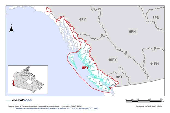
Long description for Figure 23
Map of coastal habitat in BRC 5 Pacific and Yukon Region: Northern Pacific Rainforest. The map’s extent includes British Columbia and the western portion of Alberta, along with the extreme northern portion of Washington State and the extreme southern portions of Alaska and the Yukon. The borders of BRC 4PY, 5PY, 6PN, 8PN, 9PY, 10PY and 11 PN are delineated. BRC 5 appears while the others appear differently. Inset in the lower left corner is a map of Canada with BRC 5 highlighted.
The coastal habitat in the BRC is indicated in teal. This habitat appears throughout the BRC as a thin line over all coastal areas. There are many fjords and inlets along the coast of BC, Vancouver Island and Haida Gwaii.
Beneath the map, the following bilingual legend appears: coastal/côtier [teal]. Source: Land Cover Map of Canada 2005 (CCRS, 2008), Couverture du sol du Canada 2005 (CCT, 2008). There is also a visual representation of scale for the map in the legend which indicates 0, 100, 200, 400 and 600 kms. The Projection is UTM 9 (NAD 1983).
Many species are threatened by the loss of important breeding, wintering, and stopover habitat due to development of coastal areas (Fig. 24). Some regions of BCR 5’s coasts are under intense development pressure, particularly the Strait of Georgia. Approximately 23% of the nearshore habitat around the Georgia Basin--which includes BCR 5’s most important estuarine and shorebird stopover habitat--has been urbanized, and much of the estuarine habitat has been dyked, drained, and converted to agriculture (Austin et al. 2008). Sea-level rise due to climate change will have negative impacts in coming years on mudflats, sandflats, beaches, saltmarshes, and estuaries, and the species reliant on these habitats. The Fraser River delta is particularly at risk, as valuable tidal habitat will be squeezed between the rising waters and coastal dykes; significant amounts of habitat will inevitably be lost (Bornhold 2008, Thomson et al. 2008).
Birds are also threatened by excessive human disturbance at important breeding, stopover, and wintering sites. Invasive species pose a number of significant threats, from degradation of mudflats due to invasive Spartina to the potential for introduced predators on historically predator-free nesting islands to decimate entire seabird colonies. Priority species in coastal environments are also threatened by the potential for catastrophic oil spills, and other environmental contaminants such as plastic waste, PCBs, lead, and pesticides.
Key actions to address these threats include the protection of key areas of coastal habitat, the eradication or control of invasive species, including removal of all introduced predators from seabird nesting colonies, and reducing the amount of plastic waste in the environment (Table 22). Increasing public awareness of the effects of disturbance on priority species and establishing/maintaining buffer zones around bird colonies and key foraging, stopover and roosting sites would also be beneficial. Conservation objectives and recommended actions addressing effects of climate change and environmental contaminants such as oil, lead, PCBs and pesticides are presented in the Widespread Issues section.
| Priority species | Regional habitat sub-class | Important habitat features | Population objective | At Risk (R) | CC (R) | S (R) | NAWMP (R) |
|---|---|---|---|---|---|---|---|
| American Golden-Plover | tidal flats, beaches | blank | Migrant (no population objective) | Yes | Yes | blank | blank |
| American Wigeon | estuaries, tidal flats, eelgrass | blank | Maintain current | blank | blank | blank | Yes |
| Bald Eagle | estuaries, tidal flats, rocky shoreline | veteran trees | Assess / Maintain | blank | blank | Yes | blank |
| Belted Kingfisher | estuaries, rocky shoreline | burrows | Assess / Maintain | blank | blank | Yes | blank |
| Black Oystercatcher | rocky shoreline | exposed and sheltered shoreline | Assess / Maintain | blank | Yes | Yes | blank |
| Black Scoter | rocky shoreline | shellfish beds | Increase | blank | blank | blank | Yes |
| Black Turnstone | rocky shoreline | exposed shoreline | Assess / Maintain | blank | Yes | Yes | blank |
| Black-bellied Plover | tidal flats, beach/dunes | blank | Assess / Maintain | blank | blank | Yes | blank |
| Blue-winged Teal | estuaries, saltmarsh | sheltered shoreline | Assess / Maintain | blank | blank | blank | Yes |
| Brandt's Cormorant | marine islands | kelp | Assess / Maintain | Yes | Yes | Yes | blank |
| Brant (Black) | tidal flats, estuaries, beach/dunes, eelgrass | blank | Maintain current | Yes | blank | blank | Yes |
| Brant (Western High Arctic) | tidal flats, estuaries, beach/dunes, eelgrass | blank | Assess / Maintain | Yes | blank | blank | Yes |
| Cackling Goose | estuaries, saltmarsh, tidal flats | blank | Assess / Maintain | Yes | blank | blank | Yes |
| California Gull | rocky shoreline, tidal flats, estuaries | exposed and sheltered shoreline | Assess / Maintain | Yes | blank | Yes | blank |
| Canada Goose (Dusky) | estuaries, saltmarsh, tidal flats | blank | Assess / Maintain | Yes | blank | blank | Yes |
| Canada Goose (Pacific) | estuaries, saltmarsh | blank | Maintain current | blank | blank | blank | Yes |
| Canvasback | estuaries | blank | Assess / Maintain | blank | blank | blank | Yes |
| Caspian Tern | beach/dunes, tidal flats, estuaries | blank | Assess / Maintain | Yes | blank | blank | blank |
| Cassin's Auklet | marine islands | burrows | Assess / Maintain | Yes | blank | Yes | blank |
| Common Murre | marine islands | cliffs, rocky outcrops | Assess / Maintain | Yes | blank | Yes | blank |
| Common Tern | beaches, tidal flats, estuaries | kelp | Migrant (no population objective) | blank | blank | Yes | blank |
| Double-crested Cormorant | marine islands | blank | Assess / Maintain | Yes | blank | blank | blank |
| Dunlin | tidal flats | blank | Assess / Maintain | blank | blank | Yes | blank |
| Glaucous-winged Gull | tidal flats, estuaries, beach/dunes, rocky shoreline | blank | Assess / Maintain | blank | blank | Yes | blank |
| Great Blue Heron (fannini) | tidal flats, estuaries, saltmarsh | sheltered shoreline, cottonwood riparian, veteran trees | Assess / Maintain | Yes | blank | blank | blank |
| Greater White-fronted Goose | estuaries, tidal flats | blank | Assess / Maintain | blank | blank | blank | Yes |
| Green-winged Teal | tidal flats, estuaries | blank | Assess / Maintain | blank | blank | blank | Yes |
| Gyrfalcon | estuaries, tidal flats | blank | Assess / Maintain | Yes | blank | blank | blank |
| Harlequin Duck | rocky shoreline | exposed and sheltered (rocky) shorelines | Assess / Maintain | blank | blank | blank | Yes |
| Heermann's Gull | beach/dunes, rocky shoreline | kelp | Assess / Maintain | blank | blank | Yes | blank |
| Horned Grebe | estuaries | blank | Assess / Maintain | Yes | blank | blank | blank |
| Horned Lark (strigata) | estuaries | blank | Recovery objective | Yes | blank | blank | blank |
| Horned Puffin | marine islands | cliffs | Assess / Maintain | Yes | Yes | Yes | blank |
| Leach's Storm-Petrel | marine islands | burrows | Assess / Maintain | blank | Yes | blank | blank |
| Lesser Snow Goose | estuaries | blank | Maintain current | blank | blank | blank | Yes |
| Long-billed Curlew | tidal flats, estuaries | blank | Recovery objective | Yes | Yes | blank | blank |
| Mallard | estuaries | blank | Assess / Maintain | blank | blank | blank | Yes |
| Marbled Godwit | tidal flats, estuaries, beach/dunes | blank | Assess / Maintain | blank | Yes | blank | blank |
| Northern Fulmar | marine islands | cliffs | Assess / Maintain | Yes | blank | blank | blank |
| Northern Pintail | estuaries, tidal flats, eelgrass | blank | Maintain current | blank | blank | blank | Yes |
| Northern Shoveler | estuaries | sheltered shoreline | Assess / Maintain | blank | blank | blank | Yes |
| Northwestern Crow | estuaries, tidal flats, rocky shoreline | blank | Assess / Maintain | blank | blank | Yes | blank |
| Pelagic Cormorant | marine islands | cliffs | Assess / Maintain | blank | Yes | Yes | blank |
| Peregrine Falcon (anatum) | estuaries, tidal flats, rocky shoreline | cliffs | Assess / Maintain | Yes | blank | blank | blank |
| Peregrine Falcon (pealei) | estuaries, tidal flats, rocky shoreline | cliffs, seabird colonies | Assess / Maintain | Yes | blank | blank | blank |
| Pigeon Guillemot | marine islands | burrows | Assess / Maintain | blank | blank | Yes | blank |
| Purple Martin | estuaries | cavities, nest boxes | Assess / Maintain | Yes | blank | blank | blank |
| Red Knot | tidal flats | blank | Migrant (no population objective) | Yes | Yes | Yes | blank |
| Rhinoceros Auklet | marine islands | burrows | Assess / Maintain | blank | blank | Yes | blank |
| Rock Sandpiper | rocky shoreline | blank | Assess / Maintain | blank | blank | Yes | blank |
| Ruddy Turnstone | rocky shoreline, beach/dunes, tidal flats | blank | Assess / Maintain | blank | Yes | blank | blank |
| Sanderling | beach/dunes, tidal flats | blank | Assess / Maintain | blank | Yes | blank | blank |
| Short-billed Dowitcher | estuaries, tidal flats | blank | Assess / Maintain | Yes | blank | Yes | blank |
| Short-eared Owl | estuaries, saltmarsh | blank | Assess / Maintain | Yes | blank | blank | blank |
| Snowy Owl | estuaries, tidal flats | blank | Assess / Maintain | Yes | blank | blank | blank |
| Surfbird | rocky shoreline | blank | Assess / Maintain | blank | Yes | blank | blank |
| Thayer's Gull | estuaries, saltmarsh, tidal flats | blank | Assess / Maintain | blank | blank | Yes | blank |
| Thick-billed Murre | marine islands | cliffs | Assess / Maintain | Yes | blank | Yes | blank |
| Trumpeter Swan | estuaries | blank | Maintain current | blank | blank | blank | Yes |
| Tufted Puffin | marine islands | burrows | Assess / Maintain | Yes | blank | Yes | blank |
| Tundra Swan | estuaries | blank | Assess / Maintain | Yes | blank | blank | Yes |
| Violet-green Swallow | estuaries | cavities, cliffs, nest boxes | Assess / Maintain | blank | blank | Yes | blank |
| Wandering Tattler | tidal flats, beach/dunes, rocky shoreline | exposed shoreline | Migrant (no population objective) | Yes | blank | blank | blank |
| Western Gull | tidal flats, beach/dunes, rocky shoreline | blank | Assess / Maintain | blank | blank | Yes | blank |
| Western Sandpiper | tidal flats, beach/dunes | blank | Assess / Maintain | blank | blank | Yes | blank |
| Whimbrel | tidal flats, estuaries, beach/dunes, rocky shoreline | blank | Migrant (no population objective) | blank | Yes | blank | blank |
| Wilson's Phalarope | estuaries | blank | Migrant (no population objective) | blank | Yes | blank | blank |
Note: Reasons for inclusion in the priority species list are as follows:
At Risk: the species is assessed as either Endangered, Threatened or Special Concern by COSEWIC or SARA, or the species is on the Red or Blue lists in B.C.; CC: the species meets conservation concern criteria for its bird group; S: the species meets stewardship criteria for its bird group; NAWMP: the species has NAWMP priority of Moderate-High, High or Highest in the BCR.
Long description for Figure 24
A horizontal bar graph indicating the percent of identified threats to priority species in coastal habitat (x axis) in each threat sub-category (y axis) in BCR 5 Pacific and Yukon Region.
| Threat Sub-category | Low | Medium | Highé | Very High |
|---|---|---|---|---|
| 1.1 Housing & urban areas | 6.2 | 3.3 | 1.0 | 0.5 |
| 1.2 Commercial & industrial areas | 0.0 | 0.0 | 0.0 | 0.5 |
| 1.3 Tourism & recreation areas | 2.4 | 0.0 | 0.0 | 0.5 |
| 2.1 Annual & perennial non-timber crops | 0.0 | 0.0 | 0.5 | 0.5 |
| 4.1 Roads & railroads | 1.0 | 0.5 | 0.0 | 0.0 |
| 4.2 Utility & service lines | 1.4 | 0.5 | 0.0 | 0.0 |
| 5.1 Hunting & collecting terrestrial animals | 8.1 | 3.3 | 0.0 | 0.0 |
| 6.1 Recreational activities | 4.3 | 3.8 | 1.0 | 0.0 |
| 6.3 Work & other activities | 1.9 | 0.0 | 0.0 | 0.0 |
| 7.2 Dams & water management/use | 0.5 | 0.0 | 0.0 | 0.0 |
| 7.3 Other ecosystem modifications | 0.5 | 0.0 | 0.0 | 0.0 |
| 8.1 Invasive non-native/alien species | 5.3 | 6.7 | 3.8 | 1.9 |
| 8.2 Problematic native species | 0.0 | 0.5 | 1.4 | 0.0 |
| 9.2 Industrial & military effluents | 11.0 | 3.3 | 1.0 | 0.0 |
| 9.3 Agricultural & forestry effluents | 1.4 | 1.9 | 0.0 | 0.0 |
| 9.4 Garbage & solid waste | 2.4 | 4.8 | 0.0 | 0.0 |
| 11.1 Habitat shifting & alteration | 0.5 | 3.8 | 4.3 | 1.0 |
| 11.2 Droughts | 0.0 | 0.5 | 0.0 | 0.0 |
| 11.3 Temperature extremes | 0.0 | 1.0 | 0.0 | 0.0 |
| 11.4 Storms & flooding | 1.4 | 0.0 | 0.0 | 0.0 |
Each bar represents the percent of the total number of threats identified in each threat sub-category in coastal habitat (for example, if 100 threats were identified in total for all priority species in coastal habitat, and 10 of those threats were in the category 1.1 Housing and urban areas, the bar on the graph would represent this as 10%). The bars are divided to show the distribution of Low (L), Medium (M), High (H) and Very High (VH) rankings of individual threats within each threat sub-category. For example, the same threat may have been ranked H for one species and L for another; the shading illustrates the proportion of L, M, H and VH rankings in the sub-category). The overall magnitude of the sub-threat in coastal habitat is shown at the end of each bar (also presented in Table 4. Relative magnitude of identified threats to priority species within BCR 5 Pacific and Yukon by threat category and broad habitat class).
Note: Threats of all magnitudes are included, although low ranked threats affecting only a single species were not assigned conservation objectives or recommended actions. 5.1 Hunting and collecting terrestrial animals includes hunting, illegal harvest, and lead poisoning from ingestion of lead shot. 7.3 Other ecosystem modifications refers to loss of nesting sites. 8. 1 Invasive non-native/alien species includes effects of introduced mammalian predators on seabird colonies and Spartina invasion of mudflats. 8.2 Problematic native species includes disturbance and predation by Bald Eagles. 9.2 Industrial and military effluents includes oil spills and PCBs, 9.3 Agricultural and forestry effluents refers to pesticides, and 9.4 Garbage and solid waste refers to ingestion of plastic debris.
| Threats addressed | Threat category | Objectives | Objective category | Recommended actions | Action category | Priority species affectedk |
|---|---|---|---|---|---|---|
| Loss or degradation of coastal habitats to a suite of human activity. | 1.1 Housing and urban areas 1.2 Commercial and industrial areas 1.3 Tourism and recreation areas 2.1 Annual and perennial non-timber crops 7.2 Dams and water management/ use |
Maintain and enhance the quality and diversity of coastal habitats. | 1.1 Ensure land and resource-use policies and practices maintain or improve bird habitat. | Secure and manage key areas of costal habitat for priority birds through various methods including land acquisition, conservation easements, stewardship agreements or establishment of formal parks, protected areas, or management areas. Priority areas include important stopover and wintering habitat such as estuaries, tidal sand/mud flats such as Robert's Bank, Boundary Bay, and the Tofino Mudflats, and herring spawn sites. Conduct regular surveys of all coastal habitats (including rocky shoreline habitats) to identify and map areas where large numbers or a wide diversity of priority species congregate. Consider protection of these areas. Expand the extent and protection of existing Important Bird Areas. |
1.1 Site/area protection | American Golden-Plover, Bald Eagle, Black-bellied Plover, Black Oystercatcher, Black Turnstone, Brant (Black), Brant (Western High Arctic), Dunlin, Great Blue Heron (fannini), Horned Grebe, Horned Lark (strigata), Long-billed Curlew, Red Knot, Ruddy Turnstone, Sanderling, Short-billed Dowitcher, Short-eared Owl, Surfbird, Wandering Tattler, Western Sandpiper, Whimbrel, Wilson's Phalarope |
| Predation of priority species by introduced mammalian predators. Reduced prey base due to introduced mammalian predators (Peregrine Falcon [pealei]) |
8.1 Invasive non-native/alien species | Eliminate or control invasive species while preventing future introductions. | 3.5 Prevent and control the spread of invasive and exotic species. 5.1 Maintain natural food webs and prey sources. |
Remove all introduced predators (rats, mink, raccoons) from all currently active and historical seabird colonies. Establish regular monitoring of colonies for introduced predators. Increase public and industry awareness of the impacts of introduced predators on seabird colonies and encourage the adoption of beneficial management practices to prevent future introductions or re-introductions of rats to rat-free areas. |
2.2 Invasive/prob-lematic species control 4.3 Awareness and communica-tions 8.2 Monitoring |
Black Oystercatcher, Cassin's Auklet, Common Murre, Double-crested Cormorant, Horned Puffin, Leach's Storm-Petrel, Northern Fulmar, Pelagic Cormorant, Peregrine Falcon (pealei), Pigeon Guillemot, Rhinoceros Auklet, Thick-billed Murre, Tufted Puffin |
| Habitat degradation by introduced plant species. | 8.1 Invasive non-native/alien species | Eliminate or control invasive species while preventing future introductions. | 3.5 Prevent and control the spread of invasive and exotic species. | Conduct regular inventories of the location and extent of Spartina in BCR 5, including monitoring for new infestations. Wherever possible, remove Spartina via herbicide application and/or mechanical removal. Removal should take place as quickly as possible. Educate the public and research community on how Spartina threatens shorebird habitat, and how to identify and report Spartina occurrences. Conduct research to determine the most effective methods for removing Spartina and limiting Spartina dispersal. |
2.3 Habitat and natural process restoration 4.3 Awareness and communica-tions 8.1 Research 8.2 Monitoring |
American Golden-Plover, American Wigeon, Black-bellied Plover, Brant (Black), Brant (Western High Arctic), Cackling Goose, Canada Goose (Dusky), Canada Goose (Pacific), Dunlin, Green-winged Teal, Long-billed Curlew, Mallard, Marbled Godwit, Northern Pintail, Red Knot, Ruddy Turnstone, Sanderling, Short-billed Dowitcher, Western Sandpiper, Whimbrel |
| Habitat degradation by introduced plant species. | 8.1 Invasive non-native/alien species | Eliminate or control invasive species while preventing future introductions. | 3.5 Prevent and control the spread of invasive and exotic species. | Eliminate or control introduced plant species occurring in estuaries and beach/dune habitat. Increase public awareness of invasive plant species and measures to control their spread (such as regular cleaning of vehicles and equipment, and using only native species for gardening, landscaping and re-vegetation purposes) to prevent establishment of additional invasive species. |
2.2 Invasive/prob-lematic species control 4.3 Awareness and communica-tions |
Horned Lark (strigata) |
| Loss of nesting habitat due to urban development. | 1.1 Housing and urban areas | Ensure that nesting habitat availability is not limiting Great Blue Heron (fannini) populations. | 1.4 Maintain important habitat features on the landscape. | Within the Fraser Valley, maintain woodlots with mature trees within 3 km of suitable heron foraging habitat. Establish visual barriers (e.g., tall vegetation) and reduced-activity buffer zones around heron nesting areas to prevent disturbance. | 2.1 Site/area management | Great Blue Heron (fannini) |
| Human disturbance at nesting colonies may increase reproductive failure or nest/colony abandonment. | 6.1 Recreational activities 6.3 Work and other activities |
Avoid disturbance of priority species at nesting colonies. | 4.1 Reduce disturbance from human recreation. 4.2 Reduce disturbance from industrial or work activity. 4.3 Reduce disturbance from research. |
Increase public awareness among target groups (including all recreational users of coastal habitat and commercial/industrial operations near bird colonies) of the impacts of human disturbance on priority species, and methods to minimize such disturbance. Ensure commercial tourism operators are following backcountry tourism/commercial recreation wildlife guidelines and encourage members of the public to do so as well. Establish buffer zones or seasonal closures around seabird and heron breeding colonies to prevent disturbance. |
2.1 Site/area management 4.3 Awareness and communica-tions 5.3 Private sector standards and codes |
Brandt's Cormorant, Caspian Tern, Cassin's Auklet, Double-crested Cormorant, Great Blue Heron (fannini), Pelagic Cormorant, Pigeon Guillemot, Rhinoceros Auklet |
| Human disturbance at nest sites, foraging and roosting areas. Human disturbance at staging and overwintering areas. |
6.1 Recreational activities | Avoid disturbance of priority species and prevent changes in habitat use due to disturbance. | 4.1 Reduce disturbance from human recreation. | Increase public awareness of all recreational users of coastal habitat of the impacts of human disturbance on priority species, and methods to minimize such disturbance. Use a combination of buffer zones and site closures to reduce public access to key habitat areas, such as Black Oystercatcher breeding sites, estuaries used by wintering waterfowl, and beaches, sandflats and mudflats used as stopover or wintering sites by shorebirds. Designate parks and other management areas as “On leash area only” where off leash dogs are a disturbance problem. |
2.1 Site/area management 4.3 Awareness and communica-tions |
Black-bellied Plover, Black Oystercatcher, Black Turnstone, Brant (Black), Brant (Western High Arctic), Dunlin, Sanderling, Surfbird, Trumpeter Swan, Western Sandpiper |
| Human disturbance at or development near Peregrine Falcon nest sites may lead to nest abandonment. | 6.1 Recreational activities 6.3 Work and other activities |
Avoid disturbance of nesting raptors. | 4.1 Reduce disturbance from human recreation. 4.2 Reduce disturbance from industrial or work activity. |
Maintain an undisturbed, naturally vegetated buffer of at least 50 m (urban), 200 m (rural) or 500 m (undeveloped areas) from the base of Peregrine Falcon nesting cliffs or around other Peregrine Falcon nest sites. Raise public awareness of raptors and their habitat and nesting needs. Continue to enforce British Columbia's Wildlife Act regulations around disturbance at Peregrine Falcon nests. |
5.3 Private sector standards and codes 5.4 Compliance and enforcement |
Peregrine Falcon (anatum), Peregrine Falcon (pealei) |
| Competition from House Sparrow and European Starling. | 8.1 Invasive non-native/alien species | Ensure nest site competition is not limiting populations of priority species. | 3.1 Reduce competition with invasive species. | Retain cavity-bearing trees and snags as nesting habitat. In areas where cavities are limiting, consider initiating a long-term, well-managed nest-box program (particularly for Purple Martin). Reduce and control European Starling and House Sparrow populations. This can be achieved in part by designing new structures and retrofitting existing structures to exclude nesting sites for these species. |
2.2 Invasive/prob-lematic species control 2.3 Habitat and natural process restoration 3.2 Species recovery |
Purple Martin, Violet-green Swallow |
| Predation or disturbance of priority species by Bald Eagles. | 8.2 Problematic native species | Determine if Bald Eagle predation/disturbance is negatively impacting populations of other priority species. | 7.1 Improve population/demographic monitoring. | Research is required to determine if anthropogenic factors are influencing Bald Eagle population and behaviour in the Georgia Depression, assess the degree of threat to other priority species, and identify potential mitigation strategies. | 8.1 Research | Brant (Black), Brant (Western High Arctic), Double-crested Cormorant, Great Blue Heron (fannini) |
| Malicious shooting, illegal harvest for animal parts and illegal falconry. | 5.1 Hunting and collecting terrestrial animals | Prevent killing of protected priority species in accordance with the Migratory Birds Convention Act and British Columbia's Wildlife Act. | 2.8 Reduce mortality from legal or illegal hunting, and persecution. | Increase public awareness of the legal protection of priority species under the Migratory Birds Convention Act and British Columbia's Wildlife Act. Continue to enforce existing legal protection of species. |
5.4 Compliance and enforcement | Bald Eagle, Peregrine Falcon (anatum), Peregrine Falcon (pealei), Trumpeter Swan |
| Mortality from hunting. | 5.1 Hunting and collecting terrestrial animals | Manage hunting mortality to maintain game bird populations. | 7.2 Improve harvest monitoring. | Continue to enforce legal bag and possession limits. Use adaptive management to ensure viable population levels. Promote increased hunter skill in waterfowl identification (avoid Cackling Goose or Dusky Canada Goose being mistaken for Pacific Canada Goose). |
3.1 Species management 4.2 Training 5.4 Compliance and enforcement |
Brant (Black), Brant (Western High Arctic), Cackling Goose, Canada Goose (Dusky) |
| Ingestion of plastics. Entanglement in plastics. |
9.4 Garbage and solid waste | Reduce the amount of plastic available for ingestion. Reduce the number of entangled birds. |
2.2 Reduce mortality and/or sub-lethal effects from exposure to contaminants. 2.4 Reduce incidental mortality. |
Determine the extent and impact of plastic ingestion on adult survival and reproductive success. Monitor levels of plastic pollution in the environment and determine sources. Encourage recycling programs, roadside and shoreline cleanups, and educate the public on the effects of plastic ingestion on birds to reduce the amount of plastic in the environment. Educate the public on safe disposal of items that commonly entangle birds. Encourage and support the adoption of “Zero Waste” strategies by municipal, provincial, and national governments. |
2.3 Habitat and natural process restoration 4.3 Awareness and communicat-ions 8.1 Research 8.2 Monitoring |
California Gull, Cassin's Auklet, Common Murre, Glaucous-winged Gull, Heermann's Gull, Horned Puffin, Leach's Storm-Petrel, Northern Fulmar, Pigeon Guillemot, Rhinoceros Auklet, Thayer's Gull, Thick-billed Murre, Tufted Puffin, Western Gull |
k Priority species not mentioned in this table are absent for one of the following reasons: 1) no identified threats in this habitat, 2) identified threats are discussed in the Widespread Issues section, 3) identified threats in this habitat are of low magnitude.
Riparian
Riparian areas occur adjacent to standing or flowing water where the vegetation is influenced by the presence of water and is distinct from adjacent uplands (no map is available). Riparian areas may be treed, shrubby, or herbaceous, depending on site conditions. Riparian areas are geographically restricted and form only a small part of the overall landscape. In BCR 5, there is approximately 168,500 linear km of riparian habitat, covering 81,000 ha (or < 0.1% of the BCR; Martell 2005). Despite their small representation, riparian areas are important in terms of biodiversity. Riparian areas are typically used as breeding, wintering, and stopover habitat by many species. They also serve as corridors connecting habitats and facilitating wildlife movement. Of the 12 priority species that are found in riparian habitats in BCR 5 (Table 23), there are 9 landbirds and 3 waterfowl.
Birds using riparian habitats are threatened by the loss of habitat and key habitat attributes to urban/industrial development and forestry (Fig. 25). In some areas, species are also threatened by habitat degradation due to overbrowsing by introduced/overabundant deer. Key actions to address these threats include the protection of riparian habitats, management of timber harvest to maintain important habitat attributes such as large, cavity-bearing trees, and control of introduced/overabundant deer populations (Table 24).
| Priority species | Regional habitat sub-class | Important habitat features | Population objective | At Risk (R) | CC (R) | S (R) | NAWMP (R) |
|---|---|---|---|---|---|---|---|
| Barrow's Goldeneye | forest | cavities | Maintain current | blank | blank | blank | Yes |
| Black-throated Gray Warbler | forest | blank | Assess / Maintain | blank | blank | Yes | blank |
| Bufflehead | forest | cavities | Maintain current | blank | blank | blank | Yes |
| Bullock's Oriole | forest | cottonwood riparian | Increase 100% | blank | Yes | blank | blank |
| Common Goldeneye | forest | cavities | Assess / Maintain | blank | blank | blank | Yes |
| MacGillivray's Warbler | shrub | cottonwood riparian, recent burns | Increase 50% | blank | blank | Yes | blank |
| Orange-crowned Warbler | shrub | blank | Increase 100% | blank | blank | Yes | blank |
| Pacific-slope Flycatcher | forest | blank | Assess / Maintain | blank | blank | Yes | blank |
| Rufous Hummingbird | shrub, forest | openings/clearings | Increase 100% | blank | Yes | Yes | blank |
| Vaux's Swift | forest | cavities, snags, cottonwood riparian, chimneys | Assess / Maintain | blank | blank | Yes | blank |
| Western Screech-Owl (kennicottii) | forest | cavities, openings/clearings | Assess / Maintain | Yes | blank | blank | blank |
| Willow Flycatcher | shrub | openings/clearings | Increase 100% | blank | Yes | Yes | blank |
Note: Reasons for inclusion in the priority species list are as follows:
At Risk: the species is assessed as either Endangered, Threatened or Special Concern by COSEWIC or SARA, or the species is or the species is on the Red or Blue lists in B.C.; CC: the species meets conservation concern criteria for its bird group; S: the species meets stewardship criteria for its bird group; NAWMP: the species has NAWMP priority of Moderate-High, High or Highest in the BCR.
Long description for Figure 25
A horizontal bar graph indicating the percent of identified threats to priority species in riparian habitat (x axis) in each threat sub-category (y axis) in BRC 5 Pacific and Yukon Region.
| Threat Sub-category | Low | Medium | High | Very High |
|---|---|---|---|---|
| 1.1 Housing & urban areas | 0.0 | 6.1 | 6.1 | 0.0 |
| 1.2 Commercial & industrial areas | 0.0 | 0.0 | 3.0 | 0.0 |
| 1.3 Tourism & recreation areas | 3.0 | 0.0 | 0.0 | 0.0 |
| 2.3 Livestock farming & ranching | 6.1 | 3.0 | 0.0 | 0.0 |
| 4.1 Roads & railroads | 0.0 | 0.0 | 3.0 | 0.0 |
| 4.2 Utility & service lines | 3.0 | 0.0 | 0.0 | 0.0 |
| 5.3 Logging & wood harvesting | 3.0 | 18.2 | 9.1 | 0.0 |
| 6.1 Recreational activities | 3.0 | 0.0 | 0.0 | 0.0 |
| 7.2 Dams & water management/use | 0.0 | 0.0 | 3.0 | 0.0 |
| 8.2 Problematic native species | 0.0 | 9.1 | 9.1 | 0.0 |
| 9.2 Industrial & military effluents | 0.0 | 3.0 | 0.0 | 0.0 |
| 9.3 Agricultural & forestry effluents | 6.1 | 0.0 | 0.0 | 0.0 |
| 11.1 Habitat shifting & alteration | 0.0 | 0.0 | 3.0 | 0.0 |
Each bar represents the percent of the total number of threats identified in each threat sub-category in riparian habitat (for example, if 100 threats were identified in total for all priority species in riparian habitat, and 10 of those threats were in the category 1.1 Housing and urban areas, the bar on the graph would represent this as 10%). The bars are divided to show the distribution of Low (L), Medium (M), High (H) and Very High (VH) rankings of individual threats within each threat sub-category. For example, the same threat may have been ranked H for one species and L for another; the shading illustrates the proportion of L, M, H and VH rankings in the sub-category). The overall magnitude of the sub-threat in riparian habitat is shown at the end of each bar (also presented in Table 4. Relative magnitude of identified threats to priority species within BCR 5 Pacific and Yukon by threat category and broad habitat class).
Note: Threats of all magnitudes are included, although low ranked threats affecting only a single species were not assigned conservation objectives or recommended actions. 8.2 Problematic native species refers to effects of locally overabundant deer and predation by Barred Owls. 9.2 Industrial and military effluents includes PCB and mercury exposure, and 9.3 Agricultural and forestry effluents refers to pesticides.
| Threats addressed | Threat category | Objective | Objective category | Recommended actions | Action category | Priority species affectedl |
|---|---|---|---|---|---|---|
| Loss of riparian habitat to residential and recreational developments, logging activity and hydroelectric development. | 1.1 Housing and urban areas 1.3 Tourism and recreation areas 5.3 Logging and wood harvesting 7.2 Dams and water management/use |
Maintain and enhance the quality and diversity of riparian habitats. | 1.1 Ensure land and resource-use policies and practices maintain or improve bird habitat. 1.2 Maintain the size, shape and configuration of habitat within the natural range of variation. 1.3 Ensure the continuation of natural processes that maintain bird habitat |
Secure and manage riparian habitat for priority species through various methods, including land acquisition, conservation easements, stewardship agreements or establishment of formal parks, protected areas or management areas. Maintain, restore, and where possible, expand existing riparian buffers in agricultural and developed areas. At a minimum, maintain natural riparian vegetation in buffer strips (>30m wide) on either side of the watercourse, with riparian and upland vegetation >300m wide for at least 10% of stream length. Maintain a diversity of structural stages and important habitat components, such as large, mature trees, deciduous trees, and a well developed understory. Maintain natural hydrological cycles on managed streams and rivers to maintain riparian habitats. |
1.1 Site/area protection 2.1 Site/area management 2.3 Habitat and natural process restoration 5.3 Private sector standards and codes |
Black-throated Gray Warbler, Bullock's Oriole, MacGillivray's Warbler, Orange-crowned Warbler, Pacific-slope Flycatcher, Western Screech-Owl (kennicottii), Willow Flycatcher |
| Degradation of riparian habitats due to livestock activity. | 2.3 Livestock farming and ranching | Maintain and enhance the quality and diversity of riparian habitats. | 1.1 Ensure land and resource-use policies and practices maintain or improve bird habitat. | Manage grazing to prevent degradation of riparian habitats. Where riparian areas have been degraded by livestock activity, restore and enhance habitat through fencing, livestock management, and planting native riparian vegetation. | 5.3 Private sector standards and codes | MacGillivray’s Warbler, Orange-crowned Warbler, Willow Flycatcher |
| Loss of cavity-bearing trees and snags to logging. Loss of large hollow trees and snags required for nesting and roosting by Vaux's Swift to logging. |
5.3 Logging and wood harvesting | Maintain key habitat features in riparian habitats and ensure a supply of nesting sites for priority species. | 1.4 Maintain important habitat features on the landscape. | Secure and manage riparian forest habitat to maintain key habitat features for priority species, particularly cavity-bearing trees and snags for cavity-nesting species and large hollow trees or snags as roost and nesting sites for Vaux's Swift. | 1.1 Site/area protection 5.3 Private sector standards and codes |
Barrow's Goldeneye, Bufflehead, Common Goldeneye, Vaux's Swift, Western Screech-Owl (kennicotti) |
| Degradation and loss of understory vegetation caused by introduced and/or overabundant deer. | 8.1 Invasive non-native/alien species 8.2 Problematic native species |
Ensure introduced and/or overabundant deer are not negatively impacting priority species. | 3.6 Reduce overabundant species. | Remove, reduce or control the population of introduced deer on the Haida Gwaii archipelago to maintain natural undergrowth and ground vegetation. This could be achieved in part by eliminating or increasing bag limits. In other areas where overabundant native deer are negatively impacting understory vegetation (e.g., Gulf Islands), conduct site-specific deer population control to maintain densities <0.1 deer/ha. Monitor deer density and browse intensity to identify problem areas and to evaluate the effectiveness of population control measures. |
2.2 Invasive/prob-lematic species control 2.3 Habitat and natural process restoration 5.2 Policies and regulations 8.2 Monitoring |
MacGillivray's Warbler, Orange-crowned Warbler, Pacific-slope Flycatcher, Rufous Hummingbird, Willow Flycatcher |
| Reduced survival of priority owl species due to Barred Owl competition and predation. | 8.2 Problematic native species | Determine the impacts of Barred Owl on other owl populations as Barred Owls expand their range. | 7.4 Improve understanding of causes of population declines. | Research is required to determine Barred Owl impacts on native owl populations (such as predation rates on priority species and the degree of competition for prey) and identify potential mitigation strategies. | 8.1 Research | Western Screech-Owl (kennicottii) |
l Priority species not mentioned in this table are absent for one of the following reasons: 1) no identified threats in this habitat, 2) identified threats are discussed in the Widespread Issues section, 3) identified threats in this habitat are of low magnitude.
Alpine
Alpine habitats occur at the highest elevations of the Coast Mountains in BCR 5 (Fig. 26). Areas classified as alpine begin at about 1,600 m elevation along the south coast of British Columbia and at somewhat lower elevations to the north. About 36% of BCR 5's terrestrial area is considered alpine (Martell 2005). Most vegetation within alpine areas consists of dwarf shrubs, grasses, forbs and lichens. Trees typically exist only as stunted forms at the lowest elevations of the alpine zone (BC Ministry of Forests 1998).
Long description for Figure 26
Map of alpine habitat in BRC 5 Pacific and Yukon Region: Northern Pacific Rainforest. The map’s extent includes British Columbia and the western portion of Alberta, along with the extreme northern portion of Washington State and the extreme southern portions of Alaska and the Yukon. The borders of BRC 4PY, 5PY, 6PN, 8PN, 9PY, 10PY and 11 PN are delineated. BRC 5 appears while the others appear differently. Inset in the lower left corner is a map of Canada with BRC 5 highlighted.
The alpine habitat in the BRC is indicated in maroon. This habitat type appears in moderate concentrations throughout the BRC, adjacent to high elevation areas, mostly on the mainland. There is very little alpine habitat on Vancouver Island and Haida Gwaii.
Beneath the map, the following bilingual legend appears: alpine/alpin [maroon]. Source: Land Cover Map of Canada 2005 (CCRS, 2008), Couverture du sol du Canada 2005 (CCT, 2008). There is also a visual representation of scale for the map in the legend which indicates 0, 100, 200, 400 and 600 kms. The Projection is UTM 9 (NAD 1983).
Alpine areas provide both breeding and migration habitat to a number of bird species, though only one priority species--the White-tailed Ptarmigan (saxitallis)--was identified in alpine habitat in BCR 5 (Table 25). Two threats were identified for ptarmigan: loss of habitat to development (e.g., ski hills), and loss/alteration of habitat due to climate change (Fig. 27). Loss of habitat to development was ranked Low, and as this threat affects only one priority species, conservation objectives and recommended actions were not developed for this threat. Effects of climate change (including effects on alpine habitats) and related conservation objectives are presented in the Widespread Issues section.
| Priority species | Regional habitat sub-class | Important habitat features | Population objective | At Risk (R) | CC (R) | S (R) | NAWMP (R) |
|---|---|---|---|---|---|---|---|
| White-tailed Ptarmigan (saxatilis) | tundra, subalpine meadow, rock/ice | snow fields | Assess / Maintain | Yes | blank | blank | blank |
Note: Reasons for inclusion in the priority species list are as follows:
At Risk: the species is assessed as either Endangered, Threatened or Special Concern by COSEWIC or SARA, or the species is or the species is on the Red or Blue lists in B.C; CC: the species meets conservation concern criteria for its bird group; S: the species meets stewardship criteria for its bird group; NAWMP: the species has NAWMP priority of Moderate-High, High or Highest in the BCR.
Long description for Figure 27
A horizontal bar graph indicating the percent of identified threats to priority species in alpine habitat (x axis) in each threat sub-category (y axis) in BRC 5 Pacific and Yukon Region.
| Threat Sub-category | Low | Medium | High | Very High |
|---|---|---|---|---|
| 1.3 Tourism & recreation areas | 50 | 0 | 0 | 0 |
| 11.1 Habitat shifting & alteration | 0 | 0 | 50 | 0 |
Each bar represents the percent of the total number of threats identified in each threat sub-category in alpine habitat (for example, if 100 threats were identified in total for all priority species in alpine habitat, and 10 of those threats were in the category 1.1 Housing and urban areas, the bar on the graph would represent this as 10%). The bars are divided to show the distribution of Low (L), Medium (M), High (H) and Very High (VH) rankings of individual threats within each threat sub-category. For example, the same threat may have been ranked H for one species and L for another; the shading illustrates the proportion of L, M, H and VH rankings in the sub-category). The overall magnitude of the sub-threat in alpine habitat is shown at the end of each bar (also presented in Table 4. Relative magnitude of identified threats to priority species within BCR5 Pacific and Yukon by threat category and broad habitat class).
Note: Threats of all magnitudes are included, although low ranked threats affecting only a single species were not assigned conservation objectives or recommended actions.