
Bird conservation strategy for Region 8: Ontario boreal softwood shield
- Abridged Version -
June 2014

Table of contents
- Preface
- Acknowledgements
- Bird Conservation Strategy for Bird Conservation Region 7, Prairie and Northern Region: Taiga Shield and Hudson Plains
- Executive summary
- Introduction: Bird Conservation Strategies
The abridged version of the strategy available here contains a summary of the results, but does not include an analysis of conservation needs by habitat, a discussion of widespread conservation issues, or the identification of research and monitoring needs.
To obtain a copy of the full version of this strategy, please contact migratorybirds_oiseauxmigrateurs@ec.gc.ca.
Preface
Environment and Climate Change Canada led the development of all-bird conservation strategies in each of Canada’s Bird Conservation Regions (BCRs) by drafting new strategies and integrating new and existing strategies into an all-bird framework. These integrated all-bird conservation strategies will serve as a basis for implementing bird conservation across Canada, and will also guide Canadian support for conservation work in other countries important to Canada’s migrant birds. Input to the strategies from Environment and Climate Change Canada’s conservation partners is as essential as their collaboration in implementing their recommendations.
Environment and Climate Change Canada has developed national standards for strategies to ensure consistency of approach across BCRs. Bird Conservation Strategies will provide the context from which specific implementation plans can be developed for each BCR, building on the programs currently in place through Joint Ventures or other partnerships. Landowners including Aboriginal peoples will be consulted prior to implementation.
Conservation objectives and recommended actions from the conservation strategies will be used as the biological basis to develop guidelines and beneficial management practices that support compliance with regulations under the Migratory Birds Convention Act, 1994. Furthermore, these strategies will guide conservation action in support of The State of Canada's Birds 2012 (North American Bird Conservation Initiative Canada 2012), which points to the strong influence of human activity on bird populations, both positive and negative, and presents solutions towards keeping common birds common and restoring populations which are in decline.
Acknowledgements
Brigitte Collins and Paul Smith were the main authors of this document which follows templates developed by Alaine Camfield, Judith Kennedy and Elsie Krebs with the help of the BCR planners in each of the Canadian Wildlife Service regions throughout Canada. However, work of this scope cannot be accomplished without the contribution of other colleagues who provided or validated technical information, commented on earlier draft versions of the strategy and supported the planning process. We would especially like to thank the following people: Graham Bryan, Mike Cadman, Alaine Camfield, Lesley Carpenter, Britt Dupuis, Christian Friis, Jeanette Goulet, Krista Holmes, Jack Hughes, Judith Kennedy, Sarah Mainguy, Shawn Meyer, Jocelyn Neysmith, Marie-France Noel, Michele Rodrick, Daniel Rokitnicki-Wojcik, Richard Russell, Paul Watton, Chris Wedeles, Russ Weeber and D.V. Weseloh.
Bird Conservation Strategy for Bird Conservation Region 8 in Ontario Region: Boreal Softwood Shield
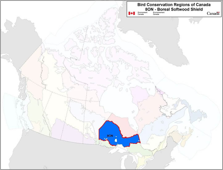
Text Description for Map
Map of the Bird Conservation Regions (BCRs) of Canada with BCR 8 ON Boreal Softwood Shield highlighted. The extent of the map includes Canada, with Alaska, Greenland and the northern portion of the U.S. also appearing. The map is divided by BCR (12 Canadian BCRs in total) and their exact locations and sizes are indistinguishable, aside from BCR 8 ON.
The highlighted BCR 8 ON covers the breadth of middle-northern Ontario, from Central Manitoba, follows the north shore of Lake superior, and extends to western Quebec, just south of James Bay.
Legend: Bird Conservation Regions of Canada. 8 ON - Boreal Softwood Shield; Environment and Climate Change Canada logo, and Government of Canada logo.
Executive Summary
The Boreal Softwood Shield Bird Conservation Region, BCR 8, spans 6 provinces and covers an area over 1,470,000 km2. The focus of this strategy is the portion of the BCR within Ontario (BCR 8 ON), comprising 30% of the total area of the BCR. BCR 8 ON covers a substantial fraction of the province (about 48%) and is its largest BCR. These strategies will serve as a framework for implementing bird conservation nationally, and also identify international conservation issues for Canada’s priority birds. This strategy is not intended to be highly prescriptive, but rather is intended to guide future implementation efforts undertaken by various partners and stakeholders.
The Boreal Softwood Shield is a region dominated by coniferous forest, underlain by Precambrian shield, and interspersed with numerous lakes, rivers and wetlands. Disturbances from fire, forestry, wind and insect outbreaks shape the composition and structure of the forest habitats at a variety of spatial and temporal scales. Tree species diversity is low, as is characteristic of boreal habitats, and bird diversity is also lower than in Ontario’s more southerly BCRs. However, the region supports a staggering abundance of birds; greater than 10% of the global population of at least 20 species are present in Ontario’s BCR 8 (BCR 8 ON) during the breeding season.
Within BCR 8 ON, 229 species of birds breed, overwinter, reside year-round or migrate through the region.Footnote[1] Of these, 71 species are identified as priorities in this BCR. All bird groups are represented on the priority species list, although the list is dominated by landbirds (65% of the priority list). The priority list also includes waterfowl (17%), waterbirds (12%), and shorebirds (6%). Over one third of the waterbirds (43%) and waterfowl (39%) occurring in BCR 8 ON are identified as priority species, as compared with 31% of the landbirds and only 14% of shorebirds. Among the 71 priority species, 12 are assessed by the Committee on the Status of Endangered Wildlife in Canada as “at risk,” 8 are listed under the federal Species at Risk Act (SARA) and 14 are listed under Ontario’s Endangered Species Act 2007 at the time of writing this strategy.
Identifying the broad habitat requirements for each priority species within the BCR allows species to be grouped by shared habitat-based conservation issues and actions. Priority species are associated with 10 habitat types in BCR 8 ON. Dense forests, primarily coniferous and mixed wood, account for 60% of the terrestrial area of this BCR and are an important habitat for many priority species (31% use coniferous, and 32% use mixed wood). Wetlands are also very important and are used by 31% of priority species (22 species). A prominent feature of the landscape of BCR 8 ON is an abundance of lakes, including Lake Superior and Lake Nipigon, and 24% of priority species use waterbodies extensively throughout the BCR. Shrub and early successional habitats as well as riparian habitats are used by 14% and 13% of priority species, respectively.
The population objectives in this strategy are categorical and are based on a quantitative or qualitative assessment of species’ population trends. Although survey coverage is far from complete, many of the priority species in BCR 8 ON have some monitoring information available. For only 3 of 71 species that are not species at risk (4%), monitoring data suggest declines with sufficient certainty to support an objective of increasing population size. Maintaining populations at current levels is the objective for 45% of the priority species in BCR 8 ON, while 25% are assigned a population objective of Assess/Maintain because monitoring data is insufficient to propose an objective. A recovery objective is assigned to 21%, or 15 species, that are considered at risk under federal and/or provincial legislation. Three priority waterfowl species (4%) are identified as migrating through BCR 8 ON and are not assigned an objective, as those are set in other BCR strategies covering the breeding range of these species.
An assessment of threats identified a number of conservation issues facing priority species in the various habitats of BCR 8 ON; however, the diversity and magnitude of threats faced by priority birds in the region are lower than in the more southerly BCRs in Ontario. Currently, the dominant threats relate to forestry, fire suppression and pollution. Although forestry is widespread in the region, much of it occurs on Crown land where provincial partners are working towards science-based management that emulates natural disturbance patterns. This active management, including consideration of birds and other wildlife, means that threats to birds from forestry are less severe than they might otherwise be. Importantly, mining, renewable energy development and the infrastructure to support these and other developments were determined to have low-magnitude effects at present, but the cumulative effects of these threats could be substantial on the birds and habitats of BCR 8 ON in the future (Far North Advisory Panel 2010). For approximately 65% of priority species, a lack of information on the population status and/or limiting factors is a major concern for effective management and conservation of priority species in BCR 8 ON.
Conservation objectives and actions have been designed to fill significant information gaps and to address the dominant threats facing priority species in the region. For BCR 8 ON, the largest proportion of objectives and actions relate to increasing the understanding of population status and limiting factors of priority species through research and monitoring. Although southern portions of the region have some coverage from large-scale surveys, much of the northern portion (and Canada’s boreal forest in general) is sparsely surveyed. As such, even basic information, such as population size and distribution, includes significant extrapolation and reliance on expert opinion for many species. An improved understanding of the population status of priority birds and the anthropogenic activities affecting their status is a prerequisite for effective conservation in BCR 8 ON. Habitat conservation objectives and actions for many priority species are consistent with current forest management objectives, which aim to ensure the supply of habitat types and forest attributes in each forest management unit and eco-region is maintained within an Estimated Range of Natural Variation. Environment and Climate Change Canada recognizes this rigorous, science-based approach to forest management in BCR 8 ON as a dominant vehicle for conservation of birds in areas where these activities occur.
Priority species in BCR 8 ON also face threats that are difficult to analyze with the standardized methodology used in this strategy. These threats include widespread issues that may sometimes not apply to a particular habitat (e.g., climate change), research needs and population monitoring, as well as threats to migratory birds when they are outside Canada. An overview of these issues, the affected species and the recommended conservation actions is also presented.
Much of the northern extent of Ontario’s BCR 8 remains a somewhat intact ecological system, free from large-scale anthropogenic disturbance, and this presents a unique opportunity to pursue development in the context of conservation, rather than vice versa. The “conservation matrix” approach advocated by the Far North Science Advisory panel holds significant promise to achieve this. However, achieving conservation successes in this region, through implementation of the recommendations contained within this strategy and others, will require broad collaboration among First Nations, provincial and federal agencies, and a number of other stakeholders.
Introduction: Bird Conservation Strategies
Context
This document is one of a suite of Bird Conservation Region Strategies (BCR Strategies) that have been drafted by Environment and Climate Change Canada for all regions of Canada. These strategies respond to Environment and Climate Change Canada’s need for integrated and clearly articulated bird conservation priorities to support the implementation of Canada’s migratory birds program, both domestically and internationally. This suite of strategies builds on existing conservation plans for the four bird groups (waterfowl,Footnote[2] waterbirds,Footnote[3] shorebirdsFootnote[4] and landbirdsFootnote[5]) in most regions of Canada, as well as on national and continental plans, and includes birds under provincial/territorial jurisdiction. These new strategies also establish standard conservation planning methods across Canada, and fill gaps, as previous regional plans do not cover all areas of Canada or all species of birds.
These strategies present a compendium of required actions based on the general philosophy of achieving scientifically based desired population levels as promoted by the four pillar initiatives of bird conservation. Desired population levels are not necessarily the same as minimum viable or sustainable populations, but represent the state of the habitat/landscape at a time prior to recent dramatic population declines in many species from threats known and unknown.
The threats identified in these strategies were compiled using currently available scientific information and expert opinion. The corresponding conservation objectives and actions will contribute to stabilizing populations at desired levels.
The BCR strategies are not highly prescriptive. In most cases, practitioners will need to consult additional information sources at local scales to provide sufficient detail to implement the recommendations of the strategies. Tools such as beneficial management practices will also be helpful in guiding implementation. Partners interested in participating in the implementation of these strategies, such as those involved in the habitat Joint Ventures established under the North American Waterfowl Management Plan, are familiar with the type of detailed implementation planning required to coordinate and undertake on-the-ground activities.
Strategy Structure
Section 1 of this strategy presents general information about the BCR and the sub-region, with an overview of the six elementsFootnote[6] that provide a summary of the state of bird conservation at the sub-regional level. Section 2 of the full version of this strategy provides more detail on the threats, objectives and actions for priority species grouped by each of the broad habitat types in the sub-region. Section 3, also available in the full version of this strategy, presents additional widespread conservation issues that are not specific to a particular habitat or were not captured by the threat assessment for individual species, as well as research and monitoring needs, and threats to migratory birds while they are outside of Canada. The approach and methodology are summarized in the appendices, but details are available in a separate document (Kennedy et al. 2012). A national database houses all the underlying information summarized in this strategy and is available from migratorybirds_oiseauxmigrateurs@ec.gc.ca.
Characteristics of Bird Conservation Region 8: Boreal Softwood Shield
BCR 8, the Boreal Softwood Shield, encompasses over 1,470,000 km2 and spans 6 provinces from Alberta to Newfoundland. The portion of BCR 8 in Ontario (BCR 8 ON) is substantial, comprising roughly 30% of the total area of the BCR (489,816 km2). BCR 8 ON covers a substantial fraction of the province (about 48%) and is its largest BCR (Figure 1). This region is characterised by extensive cover of primarily coniferous forest, with deciduous and mixed forests more common in BCR 12 ON to the south, and sparsely treed taiga and treeless tundra more common in BCR 7 ON to the North.
Figure 1. Map of Boundary Changes to BCR 8 ON: Boreal Softwood Shield.
Note: For conservation planning purposes, the original North American Bird Conservation Initiative-defined boundaries of Ontario's BCR boundaries have been slightly modified to align with the Ontario Ministry of Natural Resources Ecodistrict boundariesFootnote[7].
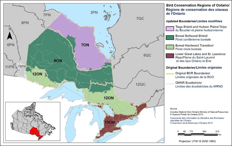
Text Description for Figure 1
Map of Ontario with the Bird Conservation Regions and their updated boundaries delineated. BCR 8 ON (Boreal Softwood Shield) covers the breadth of middle-northern Ontario, from Central Manitoba, follows the north shore of Lake superior, and extends to western Quebec, just south of James Bay. The boundaries of BCR 7 ON, BCR 12 ON, BCR 13 ON and all other adjacent BCR’s in Quebec and Manitoba are shown for context.
There is a bilingual legend on the right which indicates the ON BCRs (Taiga Shield and Hudson Plains/ Taiga du Bouclier et plaines hudsoniennes, Boreal Softwood Shield / Forêt coniférienne boréale, Boreal Hardwood Transition / Forêt mixte boréale, Lower Great Lakes and St. Lawrence Plain/Plaine du Saint-Laurent et des lacs Ontario et Érie) and the original boundaries (Original BCR Boundaries/Limites originales de la RCO, OMNR Ecodistricts / Limites des écodistrictes du MNRO). The legend also has a visual representation of the scale of the map, it indicates the projection used (UTM 16 NAD 1983) and indicates that the source of the data is the Ontario Ministry of Natural Resources, Queen’s Printer for Ontario 2013 / Ministre des ressources naturelles de l’Ontario, L’imprimeur de la Reine pour l’Ontario.
The Boreal Softwood Shield region is underlain by the Precambrian bedrock of the Canadian Shield. Topography varies throughout the region, from rugged areas of exposed bedrock in the northwestern portion of the region, to high elevation ridges inland from Lake Superior, to extensive, poorly drained, low-lying areas in the northeast. The region shows evidence of extensive glacial activity (glaciers receded some 10,000 years ago; Baldwin et al. 2000), with thin glacial till being the most widespread surficial material, and disrupted drainage patterns from glacial scouring visible throughout the region. Because of the poor and disrupted drainage, aquatic habitats are common throughout BCR 8 ON; wetlands, lakes and ponds comprise 25% of the region’s land cover (Figure 2, Table 1).
BCR 8 ON is dominated by dense boreal forest, which in comparison to the forests of southern Ontario has a limited diversity of tree species. Black spruce (Picea mariana), Jack pine (Pinus sylvestris), tamarack (Larix laricina), balsam fir (Abies balsamea), trembling aspen (Populus tremuloides), balsam poplar (Populus balsamifera) and white birch (Betula papyrifera) are the dominant species (Thompson 2000), and in various associations cover more than 60% of the landscape. Black spruce alone comprises 60% of the standing stock by volume (Ontario Ministry of Natural Resources 2006). Although the diversity of tree species is low, the boreal forest is a dynamic habitat with natural disturbances such as fire, insect outbreaks and wind operating at multiple spatial scales and over long periods of time to create a mosaic of different-aged stands and different species assemblages. Fire return times (without suppression) range from an average of approximately 50 years in the northwestern portion of BCR 8 ON to 100 years in the northeastern portion (Thompson 2000). Only 5-10% of the landscape consists of patches of old-growth forest that have escaped fire (Voigt et al. 2000, Ontario Partners In Flight 2008).
Figure 2. Map of land cover in BCR 8 ON.
Note: Riparian habitat areas are not depicted on this map because they represent a “zone” and are not a true land cover class. A map depicting the extent of derived riparian areas for illustration purposes can be found in the Riparian section of this strategy.
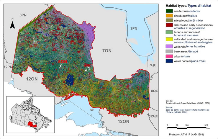
Text Description for Figure 2
Map of the landcover in BCR 8 ON: Boreal Softwood Shield. The map’s extent includes northern Ontario, eastern Manitoba and western Quebec; the borders of adjoining BCRs are delineated.
BCR 8 ON covers the breadth of middle-northern Ontario, from Central Manitoba, follows the north shore of Lake superior, and extends to western Quebec, just south of James Bay.
The various habitat types that exist in the BCR are shown on the map, and are explained in the following bilingual legend (appearing to the right of the map):
- Coniferous/conifères
- Deciduous/feuillus
- Mixedwood/forêt mixte
- Shrubs and early successional/arbustes et régénération
- lichens and mosses/lichens et mousses
- Cultivated and managed areas/zone cultivées et aménagées
- Wetlands/terres humides
- Bare areas/denude
- Urban/urbain
- Water bodies/plans d’eau
The remaining text in the legend provides the data sources for the map (i.e. Land Cover Map of Canada 2005 (CCRS, 2008), the projection of the map (i.e. UTM 9 (NAD 1983)) and there is a visual representation of the scale of the map.
For BCR 8 ON, the most common habitat types are forests (mostly mixed and coniferous), wetlands and in the northwest, shrubs.
Note: Data Source: Spectranalysis Inc., 2004. Provincial Land Cover (PLC) 27.
| BCR Habitat ClassFootnote[1] | Provincial Land Cover (PLC 27) Class(es) | Area (ha) | % of Total Area |
|---|---|---|---|
| Coniferous Forest | Forest - Dense Coniferous Forest - Sparse |
20,365,722 | 41.58% |
| Deciduous Forest | Forest - Dense Deciduous | 2,168,048 | 4.43% |
| Mixed Forest | Forest - Dense Mixed | 8,873,099 | 18.12% |
| Shrub/Early Successional | Forest Depletion - Cuts Forest Depletion - Burns Forest - Regenerating Depletion |
4,722,747 | 9.64% |
| Cultivated/Managed Areas | Agriculture - pasture/abandoned fields Agriculture - cropland |
48,706 | 0.10% |
| Bare Areas | Sand/Gravel/Mine Tailings Bedrock Coastal shorelineFootnote[2] |
189,326 16,261 |
0.39% Not Available (N/A) |
| Urban | Settlement / Infrastructure | 76,557 | 0.16% |
| WetlandsFootnote[3] | Marsh - inland Swamp - deciduous Swamp - coniferous Fen - open Fen - treed Bog - open Bog - treed |
5,911,441 | 12.07% |
| Waterbodies | Water - deep clear Water - shallow/sedimented |
6,235,581 | 12.73% |
| RiparianFootnote[4] | 30m inland from shoreline | 1,601,514 | N/A |
| Unknown | Unknown, Cloud/shadow | 390,345 | 0.80% |
| - | Total Area | 48,981,572 | 100% |
The avifauna of the region is less species-rich than in more southerly portions of the province, and few species are resident. However, what the boreal forest lacks in diversity, it makes up in abundance. BCR 8 ON supports greater than 10% of the global population of 20 landbird species, along with a significant proportion of the population for a number of waterfowl, waterbird and shorebird species such as the American Black Duck, the Bonaparte’s Gull and the Solitary Sandpiper. Populations fluctuate in abundance and distribution from year to year, especially among landbirds, in response to natural disturbances from fire and variable abundance of food (both insects and seeds vary widely in abundance from year to year). This natural variability, coupled with incomplete coverage from large-scale surveys, means that the status of bird populations in BCR 8 ON is, in some cases, poorly understood.
Human settlements and agricultural lands have a small footprint in the region (approximately a quarter percent; Table 1), but despite the sparse settlement, humans still exert a substantial influence on the region’s habitats through forestry and fire suppression. Commercial logging began in the region more than 150 years ago, but has increased dramatically in intensity in recent decades, with the total area harvested doubling every decade since 1950 (Perera and Baldwin 2000; Ontario Partners in Flight 2008). As forestry operations have increased in coverage and intensity, active suppression of forest fires has also become more widespread. Today, forest fires are suppressed across much of BCR 8 ON, and large fires spread naturally only in the northwestern portion of the region, beyond the limit of intensive forestry operations. Elsewhere in the region, timber harvest has replaced fire as the largest agent of disturbance (Perera and Baldwin 2000; Ontario Partners In Flight 2008). Still, in comparison to drastically human-altered landscapes such as BCR 13 ON, much of BCR 8 ON remains in a relatively intact state.
The Crown Forest Sustainability Act of 1994 (Statutes of Ontario 1994) legally requires that Crown forest in Ontario be managed to conserve healthy, diverse and productive forests, and their associated ecological processes and biological diversity (Pearce 2011). Management guidelines address harvest practices from local to landscape scales, including consideration of everything from retention of individual wildlife trees to landscape-level distribution of age classes. In recent years, management guidelines have been devised to emulate natural disturbance patterns and maintain forest attributes within a Simulated or Estimated Range of Natural Variation. Landscape-level guides for sustainable forestry have been completed for the Great Lakes-St. Lawrence Landscapes to the south as well as for Boreal Landscapes further north, both of which apply in BCR 8 ON (see Forest Management Guide for Boreal Landscapes, Ontario Ministry of Natural Resources 2014b). The rigorous, science-based approach to forest management in Ontario is a dominant vehicle for the conservation of birds in the region.
The forestry companies working in the boreal forest have demonstrated a willingness to work collaboratively and proactively in order to minimize the environmental impacts of their activities, for example through the signing of the Canadian Boreal Forest Agreement (Canadian Boreal Forest Agreement 2010). This agreement between 21 major Canadian forest product companies and leading environmental non-governmental organizations covers over 70 million hectares of boreal forest across the full breadth of the country. The agreement seeks to achieve a balance between environmental protection and competitiveness of Canada’s forestry sector, for example through suspension of forestry activities in key habitats for the Woodland Caribou (a Species at Risk) and by seeking market recognition for progress towards sustainable forestry practices (Canadian Boreal Forest Agreement 2010). While regulatory authority still rests with the provincial and federal governments, this historic agreement demonstrates an unprecedented commitment to protection of boreal habitats on the part of the forestry sector.
Another important piece of legislation for the conservation of the region’s wildlife and habitats is the Far North Act, 2010 (Statues of Ontario 2010). This Act, which received Royal Assent in October of 2010, provides a framework for community-based land use planning across Ontario’s North including the northern portion of BCR 8 ON. The Act is intended to ensure a significant role for First Nations in land-use planning in the region, to preserve the region’s ecological and cultural assets with a large network of protected areas (totalling more than 50% of the region’s area), to protect biodiversity and ecosystem services throughout the region, and to foster sustainable economic growth that benefits First Nations. These goals are to be met through the development and implementation of community-based land use plans, guided by a larger-scale Far North Land Use Strategy. Conservation of birds and their habitats in northern BCR 8 ON is best accomplised by recognizing the important role that these Land Use Plans will play in guiding the region’s future.
At present, approximately 14% of BCR 8 ON is protected within national parks, provincial parks and conservation reserves (Fig. 3). The largest protected areas are found within three provincial parks, namely Wabakimi (892,061 ha), Opasquia (473,000 ha) and Woodland Caribou Provincial Park (450,000 ha) and are located within the central and northwestern regions of BCR 8 ON (Ontario Ministry of Natural Resources 2014a). Pukaskwa, which is Ontario’s largest national park, protects 187,800 hectares of boreal forest and Lake Superior shoreline (Parks Canada 2014). Recent significant discoveries of minerals in the “ring of fire” mineral deposit at the boundary of BCR 8 ON and BCR 7 ON mean that the northern portion of BCR 8 ON could face increasing pressures from development. The Far North Act, 2010 has established a goal for the development of a significant network of new protected areas, and because much of BCR 8 ON remains a relatively intact ecosystem, a unique opportunity exists to define first the matrix of conservation lands needed to maintain biodiversity, ecosystem services, and natural and cultural heritage, as well as the areas where development can be sustainably pursued. This “conservation matrix” approach, advocated by the Far North Science Advisory panel (Far North Science Advisory Panel 2010), holds significant promise for the conservation of migratory birds and their habitats within BCR 8 ON. Moreover, this opportunity underscores the need for collaboration between First Nations, provincial and federal agencies, and other stakeholders to achieve the conservation objectives identified in this strategy.
Figure 3. Map of protected and designated areas in BCR 8 ON.
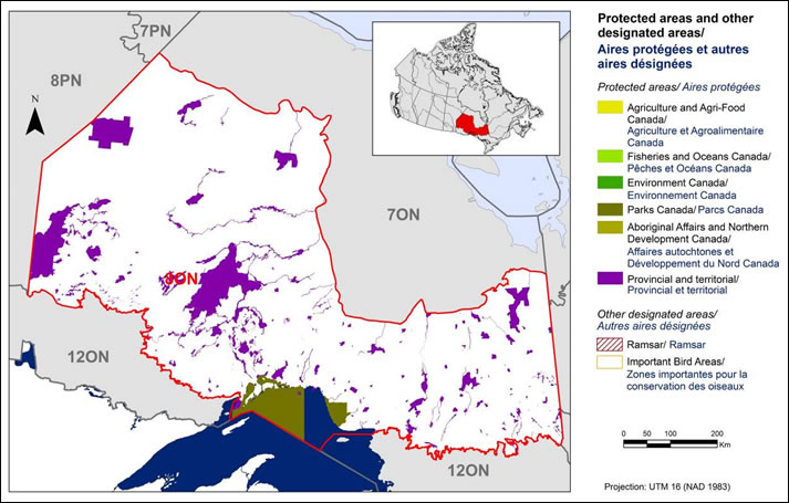
Text Description for Figure 3
Map of protected and other designated areas in BCR 8 ON: Boreal Softwood Shield. The map’s extent includes northern Ontario, eastern Manitoba and western Quebec; the borders of adjoining BCRs are delineated. BCR 8 ON covers the breadth of middle-northern Ontario, from Central Manitoba, follows the north shore of Lake superior, and extends to western Quebec, just south of James Bay.
The various types of protected areas that exist in the BCR are shown on the map, and are explained in the following bilingual legend (appearing to the right of the map):
- Protected areas/Aires protégées
- Agriculture and Agri-Food Canada/Agriculture et Agroalimentaire Canada
- Fisheries and Oceans Canada/Pêches et Océans Canada
- Environment and Climate Change Canada/Environnement et Changement climatique Canada
- Parks Canada/Parcs Canada
- Aboriginal Affairs and Northern Development Canada/Affaires autochtones et Développement du Nord Canada
- Provincial/Provincial
- Other designated areas/autres aires désignées
- Ramsar/Ramsar
- Important Bird Areas/Aires d’importance pour les oiseaux
There is also a visual representation of scale for the map in the legend and the projection of the map (i.e. UTM 9 (NAD 1983)).
The most common type of protected areas are provincial, of which there are many of large area, throughout. There is also a notably large national park along the north shore of Lake Superior.