
Bird Conservation Strategy for region 10 in Pacific and Yukon
- Abridged version -
February 2013

The abridged version of the strategy available here contains a summary of the results, but does not include an analysis of conservation needs by habitat, a discussion of widespread conservation issues, or the identification of research and monitoring needs.
Other formats available for this document:
Table of contents
- Preface
- Acknowledgements
- Bird Conservation Strategy for Bird Conservation Region 10 Pacific and Yukon Region: Northern Rockies
- Executive summary
- Introduction: Bird Conservation Strategies
- Section 1: Summary of results - All Birds, All Habitats
- References
List of figures
- Figure 1. Landcover in BCR 10 Pacific and Yukon Region: Northern Rockies.
- Figure 2. Map of protected and designated areas in BCR 10 Pacific and Yukon Region: Northern Rockies.
- Figure 3. Percent of priority species that are associated with each habitat type in BCR 10 Pacific and Yukon Region.
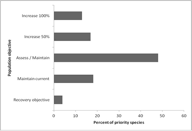
- Figure 4. Percent of priority species that are associated with each population objective category in BCR 10 Pacific and Yukon Region.
- Figure 5. Percent of identified threats to priority species within BCR 10 Pacific and Yukon Region by threat sub-category.
- Figure 6. Percent of all conservation objectives assigned to each conservation objective category in BCR 10 Pacific and Yukon Region.
- Figure 7. Percent of recommended actions assigned to each sub-category in BCR 10 Pacific and Yukon Region.
List of tables
- Table 1. Priority species in BCR 10 Pacific and Yukon Region, population objective, and the reason for priority status.
- Table 2. Summary of priority species, by bird group, in BCR 10 Pacific and Yukon Region.
- Table 3. Number of priority species in BCR 10 Pacific and Yukon by reason for priority status.
- Table 4. Relative magnitude of identified threats to priority species within BCR 10 Pacific and Yukon Region by threat category and broad habitat class.
Preface
Environment and Climate Change Canada (ECCC) led the development of all-bird conservation strategies in each of Canada’s Bird Conservation Regions (BCRs) by drafting new strategies and integrating new and existing strategies into an all-bird framework. These integrated all-bird conservation strategies will serve as a basis for implementing bird conservation across Canada, and will also guide Canadian support for conservation work in other countries important to Canada’s migrant birds. Input to the strategies from Environment and Climate Change Canada’s conservation partners is as essential as their collaboration in implementing their recommendations.
Environment and Climate Change Canada has developed national standards for strategies to ensure consistency of approach across BCRs. Bird Conservation Strategies will provide the context from which specific implementation plans can be developed for each BCR, building on the programs currently in place through Joint Ventures or other partnerships. Landowners including Aboriginal peoples will be consulted prior to implementation.
Conservation objectives and recommended actions from the conservation strategies will be used as the biological basis to develop guidelines and beneficial management practices that support compliance with regulations under the Migratory Birds Convention Act, 1994.
Acknowledgements
Ivy Whitehorne, Alaine Camfield, Veronique Connolly, Alicia Newbury, Holly Middleton and Elsie Krebs were the main authors of this document that follows templates developed by Alaine Camfield, Judith Kennedy and Elsie Krebs with the help of the BCR planners in each of the Canadian Wildlife Service regions throughout Canada. However, work of this scope cannot be accomplished without the contribution of other colleagues who provided or validated technical information, commented on earlier draft versions of the strategy, and supported the planning process. We would like to thank the following people: Andre Breault, Fred Bunnell, Rob Butler, Dick Cannings, Myke Chutter, Krista De Groot, Orville Dyer, Wendy Easton, Kevin Fort, Les Gyug, Andrew Harcombe, Bruce Harrison, Tanya Luszcz, Ian Mackenzie, Nancy Mahony, Kathleen Moore, Sampath Seneviratne and Dominique Sigg.
Bird Conservation Strategy for Bird Conservation Region 10 Pacific and Yukon Region: Northern Rockies
Text description for the map with BCR 10 PYR
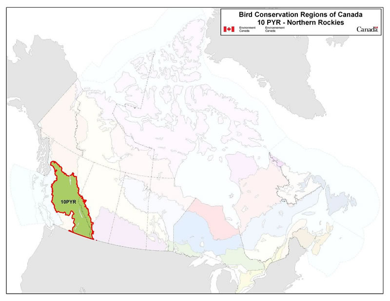
Map of the Bird Conservation Regions (BCR's) of Canada, with BCR 10, Pacific and Yukon Region: Northern Rockies highlighted. Canada (with Alaska, Greenland and the northern portion of the United States of America also appearing) is shown, as it is only present to provide context for the location of the BCR 10. The washed out Canadian map is divided by BCR (12 Canadian BCRs in total), variously, and their exact locations and sizes are indistinguishable, aside from BCR 10.
The highlighted BCR 10 covers the Columbia and Rocky Mountains from the Canada-US border in the south to the southern edge of the boreal forest in the north, and extends westward over the central plateau in the interior of British Columbia to the Coast Mountains.The following legend appears in the top right corner of the map: “Bird Conservation Regions of Canada. 10 PYR - Northern Pacific Rockies” and includes the Environment and Climate Change Canada logo, and the Government of Canada logo.
Executive summary
The Canadian portion of Bird Conservation Region (BCR) 10 is about 44 million ha in extent. It covers the Columbia and Rocky Mountains from the Canada-U.S. border in the south to the southern edge of the boreal forest in the north, and extends westward over the central plateau in interior British Columbia to the Coast Mountains. BCR 10 is one of the most ecologically diverse regions in Canada, as extremes and contrasts in topography and climate combine to create a tremendous variety of habitat types in close proximity, including lakes and ponds, wetlands, riparian areas, grasslands, shrub-steppe, dry and moist coniferous forests, and alpine tundra. Coniferous forests are the dominant land cover; alpine areas are the second most common habitat type.
This conservation strategy for BCR 10 in the Pacific and Yukon Region (PYR) builds on existing bird conservation strategies and complements those created for the other BCRs across Canada. BCR strategies will serve as a framework for implementing bird conservation nationally, and also identify international conservation issues for Canada’s priority birds. This strategy is not intended to be highly prescriptive, but rather is intended to guide future implementation efforts undertaken by various partners and stakeholders.
The diversity of habitats found in the BCR results in an equally diverse bird fauna, as there are 230 species that regularly breed, overwinter, and/or reside year-round within the region. Of these, 77 species were identified as priority species. The priority species list in this BCR is dominated by landbirds (65% of the total list) but also includes waterbirds (14%), waterfowl (16%) and shorebirds (5%). However, approximately half of all waterbirds, waterfowl, and shorebirds occurring in the BCR were identified as priority species (55%, 50% and 44%, respectively), compared to only 28% of landbirds. Forty-two per cent (42%) of the priority species are considered at risk, either federally or provincially.
Identifying the broad habitat requirements for each priority species within the BCR allowed species to be grouped by shared habitat-based conservation issues and actions. In BCR 10, a maximum of two broad-scale habitat associations were identified for each priority species. Coniferous forest habitats are used by the greatest number of priority species (28 species), reflecting the prevalence of this habitat type on the landscape in BCR 10. Wetlands are also an important habitat type in the BCR, and are used by 20 priority species. Herbaceous habitats (including native grasslands, shrubsteppe and agricultural habitats) are associated with 16 priority species, and waterbodies are also widely used (18 priority species).
The population objectives in this strategy are categorical and are based on a quantitative or qualitative assessment of species’ population trends. If the population trend of a species is unknown, the objective is set as “assess and maintain.” Forty-eight percent (48%) of priority species, with representatives from all bird groups, were assigned an objective to “assess” population status while “maintaining” current levels in the interim. For 18% of priority species, population levels were deemed to be at or near the objective. Seventeen percent (17%) and 13% of priority species were assigned objectives to increase the population by 50% and to double the population, respectively. For a small proportion of species (4%), all SARA-listed, we have deferred to the population objectives developed in Recovery Strategies.
An assessment of threats identified a number of conservation issues facing priority species in the various habitats of PYR’s BCR 10. Loss and degradation of forest habitats (coniferous, mixed and riparian habitat classes) through logging and forest harvesting were identified as the most severe threats to priority bird species in this BCR. Impacted priority species are many, but include Northern Saw-whet Owl, Barrow’s Goldeneye and Golden-crowned Kinglet. Another major threat in this BCR is natural systems modification, which is driven to a large extent by massive changes in forest structure due to the mountain pine beetle outbreak or fire suppression activities (affecting, for example, Dusky Flycatcher, Cassin’s Vireo), but also includes changes to wetlands and waterbodies arising from water management practices (affecting Western Grebe, Harlequin Duck). Threats from agricultural practices were also significant, stemming from loss or degradation of habitat due to agricultural conversion or intensification (affecting Horned Lark, Short-eared Owl) or degradation due to overgrazing (affecting Sharp-tailed Grouse, Northern Harrier). Impacts associated with climate change presented significant threats to many priority species through, for example, habitat loss or degradation (e.g., Brewer’s Sparrow taverneri, American Bittern) and temporal mismatches in peak food availability (e.g., Common Nighthawk, Rufous Hummingbird).
Conservation objectives were designed to address threats and information gaps that were identified for priority species. They describe the environmental conditions, and research and monitoring, that are thought to be necessary for progress towards population objectives and to understand underlying conservation issues for priority bird species. The majority of conservation objectives for BCR 10 relate to maintaining or enhancing habitat quality and quantity. Included in these objectives are: the maintenance of the full range of naturally occurring habitat types, maintaining the quality of existing habitats, and retaining important features on the landscape (e.g., standing dead snags for cavity nesting birds). Also important is the need to reduce mortality of priority species (which includes reducing collisions with human-made structures, destruction of nests, pesticide poisoning and mortality caused by ingestion of lead shot) and managing impacts of climate change on habitat availability and suitability. Other objectives relate to reducing human disturbance of breeding birds, ensuring pesticide use does not deplete food supplies for insectivorous birds, and targeted management of some individual priority bird species.
Recommended actions indicate on-the-ground activities that will help to achieve the conservation objectives. Actions are strategic rather than highly detailed and prescriptive, and are not prioritized. Whenever possible, recommended actions benefit multiple species, and/or respond to more than one threat. Actions relating to the development of beneficial management practices or other voluntary private sector codes of practice comprise nearly 50% of the total recommended actions. This is due in part to the fact that the development of voluntary beneficial practices are recommended to address both the need for land/water protection and management. For example, a forestry company may develop, for its area of operation, beneficial management practices (BMP) that result in the maintenance of a mosaic of habitat types, seral stages and specific important habitat features to priority bird species. As another example, ranchers may use a BMP to manage grazing in such a way as to maintain the composition, density and vigour of natural undergrowth, as well as to minimize soil compaction.
Introduction: Bird Conservation Strategies
Context
This document is one of a suite of Bird Conservation Region Strategies (BCR strategies) that have been drafted by Environment and Climate Change Canada for all regions of Canada. These strategies respond to Environment and Climate Change Canada’s need for integrated and clearly articulated bird conservation priorities to support the implementation of Canada’s migratory birds program, both domestically and internationally. This suite of strategies builds on existing conservation plans for the four “bird groups” (waterfowl,Footnote 1 waterbirds,Footnote 2 shorebirds,Footnote 3 and landbirdsFootnote 4 ) in most regions of Canada, as well as on national and continental plans, and includes birds under provincial/territorial jurisdiction. These new strategies also establish standard conservation planning methods across Canada, and fill gaps, as previous regional plans do not cover all areas of Canada or all bird groups.
These strategies present a compendium of required actions based on the general philosophy of achieving scientifically based desired population levels as promoted by the four pillar initiatives of bird conservation. Desired population levels are not necessarily the same as minimum viable or sustainable populations, but represent the state of the habitat/landscape at a time prior to recent dramatic population declines in many species from threats known and unknown. The threats identified in these strategies were compiled using currently available scientific information and expert opinion. The corresponding conservation objectives and actions will contribute to stabilizing populations at desired levels.
The BCR strategies are not highly prescriptive. In most cases, practitioners will need to consult additional information sources at local scales to provide sufficient detail to implement the recommendations of the strategies. Tools such as beneficial management practices will also be helpful in guiding implementation. Partners interested in participating in the implementation of these strategies, such as those involved in the habitat Joint Ventures established under the North American Waterfowl Management Plan (NAWMP), are familiar with the type of detailed implementation planning required to coordinate and undertake on-the-ground activities.
Strategy structure
Section 1 of this strategy, published here, presents general information about the BCR and the subregion, with an overview of the six elementsFootnote 5 that provide a summary of the state of bird conservation at the sub-regional level. Section 2, included in the full strategy, provides more detail on the threats, objectives and actions for priority species grouped by each of the broad habitat types in the subregion. Section 3, also part of the full strategy, presents additional widespread conservation issues that are not specific to a particular habitat or were not captured by the threat assessment for individual species, as well as research and monitoring needs, and threats to migratory birds while they are outside of Canada. The approach and methodology are summarized in the appendices of the full strategy, but details are available in a separate document (Kennedy et al. 2012). A national database houses all the underlying information summarized in this strategy and is available from Environment and Climate Change Canada.
Characteristics of Bird Conservation Region 10: Northern Rockies
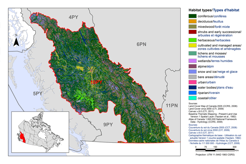
The Canadian portion of BCR 10 is about 44 million hectares in extent, and covers the Columbia and Rocky Mountains from the Canada-U.S. border in the south to the southern edge of the boreal forest in the north, and extends westward over the central plateau in interior British Columbia to the Coast Mountains (Fig. 1). BCR 10 is one of the most ecologically diverse regions in Canada (Ecological Stratification Working Group 1995), as extremes and contrasts in topography and climate combine to create a tremendous variety of habitat types in close proximity, including lakes and ponds, wetlands, riparian areas, grasslands, shrub-steppe, dry and moist coniferous forests, and alpine tundra (CIJV Technical Committee 2010). Coniferous forests are the dominant land cover (56% of the BCR); alpine areas are the second most common habitat type (10%; CIJV 2009). There is a diversity of habitats in the BCR and a high number of bird species, with 230 species that regularly breed, overwinter, and/or reside year-round within the region.
Figure 1. Landcover in BCR 10 Pacific and Yukon Region: Northern Rockies.
Text Description for Figure 1
Map of the landcover in BCR 10 Pacific and Yukon Region: Northern Rockies. The map's extent includes British Columbia and the western portion of Alberta, along with the extreme northern portion of Washington State and the extreme southern portions of Alaska. The borders of BCR 4PY, 5PY, 6PN, 9PY and 10PY are delineated. BCR 10 appears while the others appear differently. Inset in the lower left corner is a map of Canada with BCR 10 highlighted.
BCR 10 covers the Columbia and Rocky Mountains from the Canada-US border in the south to the southern edge of the boreal forest in the north, and extends westward over the central plateau in the interior of British Columbia to the Coast Mountains.
The various habitat types that exist in the BCR are shown on the map diversely, which are explained in the following bilingual legend (appearing to the right of the map):
- Coniferous/conifères
- Deciduous/feuillus
- Mixedwood/forêt mixte
- Shrubs and early successional/arbustes et regeneration
- Herbaceous/herbacées
- Cultivated and managed areas/zone cultivées et aménagées
- Lichens and mosses/lichens et mousses
- Wetlands/terres humides
- Alpine/alpin
- Snow and ice/neige et glace
- Bare areas/denude
- Urban/urbain
- Water bodies /plans d'eau
- Riparian/riverain
- Coastal/côtier
The most common habitat types visible at this scale in BCR 10 are coniferous forests throughout and waterbodies in the valleys. There is a concentration of alpine and wetland habitat in the extreme northwest of the BCR, and a concentration of herbaceous habitat in the central-west portion of the BCR. The other habitat types occur in smaller concentrations throughout the BCR, except for costal, which is absent.
The remaining text in the legend is the following: Sources: Land Cover Map of Canada 2005 (CCRS, 2008), Land Cover circa 2000 (CTI, 2009), Canvec v. 9.0 (CTI, 2011), Baseline Thematic Mapping - Present Land Use Version 1 Spatial Layer (Yazdani et al., 1992), Atlas of Canada 1,000,000 National Framework Data - Hydrology (CCRS, 2008). Sources: Couverture du sol du Canada 2005 (CCT, 2008), Couverture du sol circa 2000 (CTI, 2009), Canvec v. 9.0 (CTI, 2011), Cartographe thématique de base - Utilisation du sol actuelle Version 1 couche spatiale (Yazdani, 1992), Données-cadre nationales de l'Atlas du Canada à l'échelle du 1/1 000 000 - Hydrologie (CCT, 2008). There is also a visual representation of scale for the map in the legend which indicates 0, 75, 150 and 300 kms. The Projection is UTM 11 (UTM 1983 CSRS).
BCR 10 has a relatively small population, with approximately 400,000 people living in the BCR in 2006 (Harding 2009). Prince George (pop. 83,000) is the largest urban centre (Statistics Canada 2008). A relatively high percentage of the BCR (about 19%, over 8.3 million ha) is protected within national and provincial parks and other protected areas (CIJV Technical Committee 2010; Fig. 2).
Figure 2. Map of protected and designated areas in BCR 10 Pacific and Yukon Region: Northern Rockies.
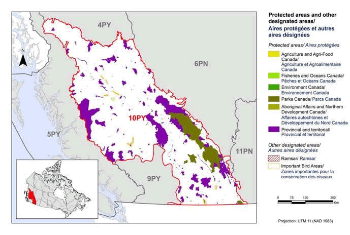
Text description for Figure 2
Map of protected and designated areas in BCR 10 Pacific and Yukon Region: Northern Rockies. The map's extent includes British Columbia and the western portion of Alberta, along with the extreme northern portion of Washington State and the extreme southern portions of Alaska. The borders of BCR 4PY, 5PY, 6PN, 9PY and 10PY are delineated. BCR 10 appears emphasized while the others appear otherwise. Inset in the lower left corner is a map of Canada with BCR 10 highlighted.
BCR 10 covers the Columbia and Rocky Mountains from the Canada-US border in the south to the southern edge of the boreal forest in the north, and extends westward over the central plateau in the interior of British Columbia to the Coast Mountains.
The various types of protected areas that exist in the BCR are shown on the map variously, which are explained in the following bilingual legend (appearing to the right of the map):
Protected areas/Aires protégées
- Agriculture and Agri-Food Canada/Agriculture et Agroalimentaire Canada
- Fisheries and Oceans Canada/Pêches et Océans Canada
- Environment and Climate Change Canada/Environnement et Changement climatique Canada
- Parks Canada/Parcs Canada
- Aboriginal Affairs and Northern Development Canada/Affaires autochtones et Développement du Nord Canada
- Provincial/Provincial
Other designated areas/Autres aires désignées
- Ramsar/Ramsar
- Important Bird Areas/Aires d'importance pour les oiseaux
The most common type of protected area shown is provincial, appearing as a patchwork throughout the whole BCR, with the largest areas occurring along the centres of the BCR's eastern and western borders. There are also four National Parks of note, the largest one occurring along a large section of the BCR's western border. There are several small Important Bird Areas throughout.
There is also a visual representation of scale for the map in the legend which indicates 0, 75, 150 and 300 kms. The Projection is UTM 11 (UTM 1983).
Despite its small population size and remote and rugged terrain, much of BCR 10 is a managed, working landscape. Resource-based industries such as agriculture, ranching, forestry and mining, as well as tourism and recreation, are the key economic activities in the region (CIJV Technical Committee 2010). The threats to priority bird species identified within BCR 10 reflect these activities. For example, native grasslands have been almost completely converted to agriculture, and forest structure has been heavily altered through extensive timber harvest. The current outbreak of mountain pine beetle in British Columbia, which spans all of BCR 10 and is unprecedented in scope, poses risks for many priority species using forest habitats. Climate change is also expected to have broad impacts across the BCR, particularly in alpine and wetland habitats (Pojar 2010, CIJV Technical Committee 2010).
Section 1: Summary of results - All Birds, All Habitat
Element 1: Priority species assessment
These Bird Conservation Strategies identify “priority species” from all regularly occurring bird species in each BCR subregion. Species that are vulnerable due to population size, distribution, population trend, abundance and threats are included because of their “conservation concern.” Some widely distributed and abundant “stewardship” species are also included. Stewardship species are included because they typify the national or regional avifauna and/or because they have a large proportion of their range and/or continental population in the subregion; many of these species have some conservation concern, while others may not require specific conservation effort at this time. Species of management concern are also included as priority species when they are at (or above) their desired population objectives but require ongoing management because of their socio-economic importance as game species or because of their impacts on other species or habitats.
The purpose of the prioritization exercise is to focus implementation efforts on the issues of greatest significance for Canadian avifauna. Table 1 provides a full list of all priority species and their reason for inclusion. Tables 2 and 3 summarize the number of priority species in BCR 10 Pacific and Yukon Region by bird group and by the reason for priority status.
In BCR 10, the priority species list is dominated by landbirds (50 species) but also includes waterbirds (11 species), waterfowl (12 species) and shorebirds (4 species). However, approximately half of all waterbirds, waterfowl, and shorebirds occurring in the BCR were identified as priority species (55%, 50% and 44%, respectively), compared to only 28% of landbirds. Forty-two percent (42%) of the priority species are considered at risk, either federally or provincially.
In BCR 10, the Canada Goose was identified as a priority species. Historically, Canada Goose populations in southern BC were characterized by very low densities and a scattered distribution, but through transplant programs and natural dispersal, this species has expanded its distribution and abundance significantly over the last three decades. In this plan, population objectives, identified threats and recommended actions related to the Canada Goose refer solely to migratory populations, and do not refer to resident populations that both breed and winter in urban areas. These resident populations are responsible for a high incidence of conflicts with humans, and urban authorities (such as municipal governments) may elect to set population objectives for Canada geese and manage toward that goal through habitat modification and control measures.
Table 1. Priority species in BCR 10 Pacific and Yukon Region, population objective, and the reason for priority status. Accessible Version of Table 1.
| Bird group | Total species | Total priority species | Percent listed as priority | Percent of priority list |
|---|---|---|---|---|
| Landbirds | 177 | 50 | 28 % | 65 % |
| Shorebirds | 9 | 4 | 44 % | 5 % |
| Waterbirds | 20 | 10 | 50 % | 13 % |
| Waterfowl | 24 | 12 | 50 % | 16 % |
| Total | 230 | 76 | 100 % |
| Reason for priority listinga | Landbirds | Shorebirds | Waterbirds | Waterfowl |
|---|---|---|---|---|
| COSEWICb | 13 | 1 | 1 | - |
| Federal SARA listedc | 11 | 1 | 1 | - |
| Provincially listedd | 17 | 3 | 7 | 2 |
| NAWMPe | - | - | - | 10 |
| National/Continental Concern | 13 | 2 | 1 | - |
| Regional Concern | 18 | - | - | - |
| National/Continental Stewardship | 7 | - | - | - |
| Regional Stewardship | 24 | - | 5 | - |
a A single species can be on the priority list for more than one reason. Note that not all reasons for inclusion apply to every bird group (indicated by “-”).
b COSEWIC indicates species assessed by COSEWIC as Endangered, Threatened, or Special Concern.
c Species listed on Schedule 1 of the Species at Risk Act as Endangered, Threatened, or Special Concern.
d Provincially Listed indicates species assessed by the province of Alberta as Endangered, Threatened, or Special Concern, or Red-listed or Blue-listed by British Columbia's Conservation Data Centre.
d NAWMP indicates species ranked in the North American Waterfowl Management Plan (Plan Committee 2004) as having Highest, High or Moderately High breeding or non-breeding conservation and/or monitoring need in the BCR.
Element 2: Habitats important to priority species
Identifying the broad habitat requirements for each priority species within the BCR allowed species to be grouped by shared habitat-based conservation issues and actions for details on how species were assigned to standard habitat categories). If many priority species associated with the same habitat face similar conservation issues, then conservation action in that habitat may support populations of several priority species. BCR strategies use a modified version of the standard land cover classes developed by the United Nations (Food and Agriculture Organization 2000) to categorize habitats and species were often assigned to more than one habitat class.
In BCR 10, a maximum of two habitat associations were identified for each priority species. Coniferous forest habitats are used by the greatest number of priority species (28), reflecting the prevalence of this habitat type on the landscape in BCR 10. Wetlands are also an important habitat type in the BCR, and are used by 20 priority species. Herbaceous habitats (16 priority species) and waterbodies (18 priority species) are also widely used (Fig. 3).
Figure 3. Percent of priority species that are associated with each habitat type in BCR 10 Pacific and Yukon Region.
Note: The total exceeds 100% because each species may be assigned to more than one habitat.
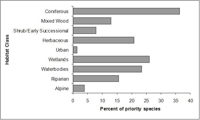
Text Description for Figure 3
| Habitat class | Percent of Priority Species |
|---|---|
| Coniferous | 36.4 |
| Mixed Wood | 13.0 |
| Shrub/Early Successional | 7.8 |
| Herbaceous | 20.8 |
| Urban | 1.3 |
| Wetlands | 26.0 |
| Waterbodies | 23.4 |
| Riparian | 15.6 |
| Alpine | 3.9 |
Element 3: Population objectives
Population objectives allow us to measure and evaluate conservation success. The objectives in this strategy are assigned to categories and are based on a quantitative or qualitative assessment of species’ population trends. If the population trend of a species is unknown, the objective is set as “assess and maintain,” and a monitoring objective is given. For any species listed under the Species at Risk Act (SARA) or under provincial/territorial endangered species legislation, Bird Conservation Strategies defer to population objectives in available Recovery Strategies and Management Plans. The ultimate measure of conservation success will be the extent to which population objectives have been reached over the next 40 years. Population objectives do not currently factor in feasibility of achievement, but are held as a standard against which to measure progress.
The population objectives in this strategy are categorical and are based on a quantitative or qualitative assessment of species’ population trends. If the population trend of a species is unknown, the objective is set as “assess and maintain.” Forty-eight percent (48%) of priority species, with representatives from all bird groups, were assigned an objective to “assess” population status while “maintaining” current levels in the interim (Fig. 4). For 18% of species, population levels were deemed to be at or near the objective. Seventeen percent and 13% of species were assigned objectives to increase the population by 50% and to double the population, respectively. For a small proportion of species (4%), all SARA-listed, we have deferred to the population objectives developed in Recovery Strategies.
Figure 4. Percent of priority species that are associated with each population objective category in BCR 10 Pacific and Yukon Region.
Text Description for Figure 4
| Population Objective | Percent of Priority Species |
|---|---|
| Assess / Maintain | 48.05 |
| Increase 100 % | 12.99 |
| Increase 50 % | 16.88 |
| Maintain current | 18.18 |
| Recovery Objectives | 3.9 |
Element 4: Threat assessment for priority species
The threats assessment process see identifies threats believed to have a population-level effect on individual priority species. These threats are assigned a relative magnitude (Low, Medium, High, Very High), based on their scope (the proportion of the species’ range within the subregion that is impacted) and severity (the relative impact on the priority species’ population). This allows us to target conservation actions towards threats with the greatest effects on suites of species or in broad habitat classes. Some well known conservation issues (such as predation by domestic cats or climate change) may not be identified in the literature as significant threats to populations of an individual priority species and therefore may not be captured in the threat assessment. However, they merit attention in conservation strategies because of the large numbers of individual birds affected in many regions of Canada. We have incorporated them in a separate section on widespread issues but, unlike other threats, they are not ranked.
An assessment of threats identified a number of conservation issues facing priority species in the various habitats of PYR’s BCR 10. Loss and degradation of forest habitats (coniferous, mixed and riparian habitat classes) through logging and forest harvesting was identified as the most severe threat to priority bird species in this BCR (Fig. 5 and Table 4). Impacted species are many, but include among the priority species Northern Saw-whet Owl, Barrow’s Goldeneye, and Golden-crowned Kinglet. Another major threat in this BCR is natural systems modification, which is driven to a large extent by massive changes in forest structure due to the mountain pine beetle outbreak or fire suppression activities (affecting, for example, Dusky Flycatcher, Cassin’s Vireo), but also includes changes to wetlands and waterbodies arising from water management practices (affecting Western Grebe, Harlequin Duck). Threats from agricultural practices were also significant, stemming from loss or degradation of habitat due to agricultural conversion or intensification (affecting Horned Lark, Short-eared Owl) or degradation due to overgrazing (affecting Sharp-tailed Grouse, Northern Harrier). Impacts associated with climate change presented significant threats to many species through, for example, habitat loss or degradation (e.g., Brewer’s Sparrow taverneri, American Bittern) and temporal mismatches in peak food availability (e.g., Common Nighthawk, Rufous Hummingbird).
Figure 5. Percent of identified threats to priority species within BCR 10 Pacific and Yukon Region by threat sub-category.
Each bar represents the percent of the total number of threats identified in each sub-threat category in BCR 10 (for example, if 100 threats were identified in total for all priority species in BCR10, and 10 of those threats were in the category 1.1 Housing and urban areas, the bar on the graph would represent this as 10%). Shading in the bars (VH = very high, H = high, M = medium and L = low) represents the rolled up magnitude of all threats in each threat subcategory in the BCR. 5.1 Hunting and collecting terrestrial animals refers primarily to lead poisoning of waterfowl from consumption of lead shot. Threats under 6.1 Recreation activities and 6.3 Work and other activities refer to the impacts of human disturbance from these activities. Threats under 7.3 Other ecosystem modifications are primarily changes in forest structure due to the Mountain Pine Beetle outbreak. 8.2 Problematic native species refers primarily to Brown-headed Cowbird parasitism. 9.3 Agricultural and forestry effluents refers primarily to effects of pesticide use.
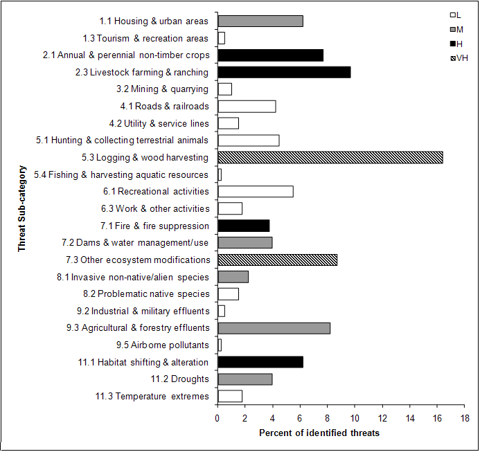
Text Description for Figure 5
A horizontal bar graph indicating the percent of identified threats to priority species (x axis) within BCR 10 Pacific and Yukon Region by threat subcategory (y axis; i.e. Recreational Activities, Droughts, etc.).
Each bar represents the percent of the total number of threats identified in each sub-threat category in BCR 10 (for example, if 100 threats were identified in total for all priority species in BCR 10, and 10 of those threats were in the category 1.1 Housing and urban areas, the bar on the graph would represent this as 10%). Emphasizing in the bars (VH = very high, H = high, M = medium and L = low) represents the rolled up magnitude of all threats in each threat subcategory in the BCR.
| Threat Sub-category | Low | Medium | High | Very High |
|---|---|---|---|---|
| 1.1 Housing and urban areas | 0.00 | 6.20 | 0.00 | 0.00 |
| 1.3 Tourism and recreation areas | 0.50 | 0.00 | 0.00 | 0.00 |
| 2.1 Annual and perennial non-timber crops | 0.00 | 0.00 | 7.69 | 0.00 |
| 2.3 Livestock farming and ranching | 0.00 | 0.00 | 9.68 | 0.00 |
| 3.2 Mining and quarrying | 0.99 | 0.00 | 0.00 | 0.00 |
| 4.1 Roads and rail roads | 4.22 | 0.00 | 0.00 | 0.00 |
| 4.2 Utility and service lines | 1.49 | 0.00 | 0.00 | 0.00 |
| 5.1 Hunting and collecting terrestrial animals | 4.47 | 0.00 | 0.00 | 0.00 |
| 5.3 Logging and wood harvesting | 0.00 | 0.00 | 0.00 | 16.38 |
| 5.4 Fishing and harvesting aquatic resources | 0.25 | 0.00 | 0.00 | 0.00 |
| 6.1 Recreational activities | 5.46 | 0.00 | 0.00 | 0.00 |
| 6.3 Work and other activities | 1.74 | 0.00 | 0.00 | 0.00 |
| 7.1 Fire and fire suppression | 0.00 | 0.00 | 3.72 | 0.00 |
| 7.2 Dams and water management/use | 0.00 | 3.97 | 0.00 | 0.00 |
| 7.3 Other ecosystem modifications | 0.00 | 0.00 | 0.00 | 8.68 |
| 8.1 Invasive non-native/alien species | 0.00 | 2.23 | 0.00 | 0.00 |
| 8.2 Problematic native species | 1.49 | 0.00 | 0.00 | 0.00 |
| 9.2 Industrial and military effluents | 0.50 | 0.00 | 0.00 | 0.00 |
| 9.3 Agricultural and forestry effluents | 0.00 | 8.19 | 0.00 | 0.00 |
| 9.5 Airborne pollutants | 0.25 | 0.00 | 0.00 | 0.00 |
| 11.1 Habitat shifting and alteration | 0.00 | 0.00 | 6.20 | 0.00 |
| 11.2 Droughts | 0.00 | 3.97 | 0.00 | 0.00 |
| 11.3 Temperature extremes | 1.74 | 0.00 | 0.00 | 0.00 |
| Threat category | Habitat class Coniferous |
Habitat class Mixed |
Habitat class Shrub/Early Successional |
Habitat class Herbaceous |
Habitat class Urban |
Habitat class Wetlands |
Habitat class Waterbodies |
Habitat class Riparian |
Habitat class Alpine |
Habitat class Overall |
|---|---|---|---|---|---|---|---|---|---|---|
| Overall | VH | VH | M | H | L | H | H | H | M | |
| 1 Residential and commercial development | L | L | L | L | M | L | H | L | M | |
| 2 Agriculture and aquaculture | M | L | VH | H | M | H | H | |||
| 3 Energy production and mining | L | L | L | L | ||||||
| 4 Transportation and service corridors | L | L | L | L | L | L | L | L | ||
| 5 Biological resource use | VH | VH | L | L | L | M | H | VH | ||
| 6 Human intrusions and disturbance | L | L | L | L | L | M | L | L | ||
| 7 Natural system modifications | VH | VH | H | H | L | M | H | M | VH | |
| 8 Invasive and other problematic species and genes | M | M | L | L | M | M | ||||
| 9 Pollution | M | L | L | H | M | M | H | L | H | |
| 11 Climate change and severe weather | H | L | M | M | L | H | M | H | H | H |
Threats to priority species while they are outside Canada during the non-breeding season were also assessed and are presented in the Threats Outside of Canada section.
Element 5: Conservation objectives
Conservation objectives were designed to address threats and information gaps that were identified for priority species. They describe the environmental conditions and research and monitoring that are thought to be necessary for progress towards population objectives and to understand underlying conservation issues for priority bird species. As conservation objectives are reached they will collectively contribute to achieving population objectives. Whenever possible, conservation objectives were developed to benefit multiple species, and/or respond to more than one threat.
The majority of conservation objectives for BCR 10 relate to maintaining or enhancing habitat quality and quantity (Fig. 6). Included in these objectives are the maintenance of the full range of naturally-occurring habitat types, maintaining the quality of existing habitats, and retaining important features on the landscape (e.g., standing dead snags for cavity nesting birds). Also important is the need to reduce mortality of priority species (which includes reducing collisions with man-made structures, destruction of nests, pesticide poisoning, and mortality caused by ingestion of lead shot) and managing impacts of climate change on habitat availability and suitability. Other objectives relate to reducing human disturbance of breeding birds, ensuring pesticide use does not deplete food supplies for insectivorous birds, and targeted management of some individual priority species.
Figure 6. Percent of all conservation objectives assigned to each conservation objective category in BCR 10 Pacific and Yukon Region.

Text Description for Figure 6
| Conservation Objective | Percent of Conservation Objectives |
|---|---|
| 1 Ensure adequate habitat | 56.2 |
| 2 Reduce mortality/increase productivity | 19.1 |
| 3 Manage individual species | 2.9 |
| 4 Reduce disturbance | 4.8 |
| 5 Ensure adequate food supplies | 3.7 |
| 6 Manage for climate change | 12.7 |
| 7 Improve understanding | 0.5 |
Element 6: Recommended actions
Recommended actions indicate on-the-ground activities that will help to achieve the conservation objectives (Fig. 7). Actions are strategic rather than highly detailed and prescriptive. Whenever possible, recommended actions benefit multiple species, and/or respond to more than one threat. Recommended actions defer to or support those provided in recovery documents for species at risk at the federal, provincial or territorial level, but will usually be more general than those developed for individual species.
Actions relating to the development of beneficial management practices (BMPs) or other voluntary private sector codes of practice comprise nearly 50% of the total recommended actions. This is due in part, to the fact that the development of voluntary beneficial practices are recommended to address both the need for land/water protection and management. For example, a forestry company may develop, for their area of operation, BMPs that result in the maintenance of a mosaic of habitat types, seral stages, and specific important habitat features. As another example, ranchers may use a BMP to manage grazing in such a way as to maintain the composition, density and vigour of natural undergrowth, as well as to minimize soil compaction.
Figure 7. Percent of recommended actions assigned to each sub-category in BCR 10 Pacific and Yukon Region.
“Research” and “monitoring” refers to specific species where additional information is required. 5.3 Private sector standards and codes includes adoption of voluntary codes of practice, including sector-specific Beneficial Management Practices for bird conservation. 8.1 Research and 8.2 Monitoring refer to specific priority species where information is required before conservation actions can be formulated. For a discussion of broad-scale research and monitoring requirements, see the section on Research and Monitoring Needs.

Text Description for Figure 7
| Action Sub-category | Percent of Recomended Actions |
|---|---|
| 1.1 Site/area protection | 9.94 |
| 1.2 Resource and habitat protection | 8.92 |
| 2.1 Site/area management | 12.78 |
| 2.2 Invasive/problematic species control | 1.83 |
| 2.3 Habitat and natural process restoration | 7.71 |
| 3.2 Species recovery | 1.22 |
| 4.3 Awareness and communications | 4.46 |
| 5.2 Policies and regulations | 1.01 |
| 5.3 Private sector standards and codes | 48.68 |
| 8.1 Research | 2.64 |
| 8.2 Monitoring | 0.81 |
References
CIJV. 2003. The Canadian Intermountain Joint Venture: Biological Foundation and Prospectus. Canadian Intermountain Joint Venture. 71 pp.
CIJV. 2009. EOSDmod land cover dataset. Accessed 9 November 2009.
CIJV Technical Committee. 2010. Canadian Intermountain Joint Venture Implementation Plan: Wetlands and Associated Species. viii+ 64 pp.
Donaldson, G. M., C. Hyslop, R. I. G. Morrison, H. L. Dickson, and I. Davidson (editors). 2000. Canadian Shorebird Conservation Plan. Canadian Wildlife Service, Environment and Climate Change Canada, Ottawa, Ontario. 27 pp.
Ecological Stratification Working Group. 1995. A National Ecological Framework for Canada. Agriculture and Agri-Food Canada, Research Branch, Centre for Land and Biological Resources Research and Environment and Climate Change Canada, State of the Environment Directorate, Ecozone Analysis Branch, Ottawa/Hull. Report and national map at 1:7500 000 scale. - see Montane Cordillera ecozone
Food and Agriculture Organization (FAO). 2000. Land cover classification system. United Nations Food and Agriculture Organization, Rome.
Harding, L. 2009. Montane Cordillera EcozonePlus Status and Trends Assessment [draft June 2009]. Prepared by SciWrite Environmental Sciences Ltd. Coquitlam, B.C.
Kennedy, J.A., E.A. Krebs and A.F. Camfield. 2012. A Manual for Completing All-bird Conservation Plans in Canada, April 2012 version. Canadian Wildlife Service, Environment and Climate Change Canada. Ottawa, ON
Milko, R., L. Dickson, R. Elliot, and G. Donaldson. 2003. Wings Over Water: Canada’s Waterbird Conservation Plan. Canadian Wildlife Service, Environment and Climate Change Canada, Ottawa, Ontario. 28 pp.
North American Waterfowl Management Plan, Plan Committee. 2004. North American Waterfowl Management Plan 2004. Implementation Framework: Strengthening the Biological Foundation. Canadian Wildlife Service, U.S. Fish and Wildlife Service, Secretaria de Medio Ambiente y Recursos Naturales, 106 pp.
Pojar, J. 2010. A new climate for conservation - Nature, carbon and climate change in British Columbia. 100 pp.
Rich, T.D., C.J. Beardmore, H. Berlanga, P.J. Blancher, M.S.W. Bradstreet, G.S. Butcher, D.W. Demarest, E.H. Dunn, W.C. Hunter, E.E. Iñigo-Elias, J.A. Kennedy, A.M. Martell, A.O. Panjabi, D.N. Pashley, K.V. Rosenberg, C.M. Rustay, J.S. Wendt, T.C. Will. 2004. Partners in Flight North American Landbird Conservation Plan. Cornell Lab of Ornithology. Ithaca, NY.
Rocky Mountain Bird Observatory. 2005. Partners in Flight Species Assessment database (online)
Species at Risk Public Registry. Accessed 4 April 2012. Schedule 1: List of Wildlife Species at Risk.