
Bird Conservation Strategy for region 3 in Quebec
- Abridged version -
October 2013

The abridged version of the strategy available here contains a summary of the results, but does not include an analysis of conservation needs by habitat, a discussion of widespread conservation issues, or the identification of research and monitoring needs.
Other formats available for this document:
Table of contents
- Preface
- Acknowledgements
- Bird Conservation Strategy for Bird Conservation Region 3 in Quebec Region: Arctic Plains and Mountains
- Executive summary
- Introduction: Bird Conservation Strategies
- Section 1: Summary of results - All Birds, All Habitats
- References
List of figures
- Figure 1: Landcover in BCR 3-QC: Arctic Plains and Mountains.
- Figure 2: Map of protected areas in BCR 3-QC: Arctic Plains and Mountains.
- Figure 3: Percent of priority species that are associated with each habitat type in BCR 3-QC.
- Figure 4: Percent of priority species that are associated with each population objective category in BCR 3-QC.
- Figure 5: Percent of identified threats to priority species within BCR 3-QC by threat sub-category.
- Figure 6: Percent of all conservation objectives assigned to each conservation objective category in BCR 3-QC.
- Figure 7: Percent of recommended actions assigned to each sub-category in BCR 3-QC.
List of tables
- Table 1: Priority species in BCR 3-QC, population objective and the reason for priority status.
- Table 2: Summary of priority species, by bird group, in BCR 3-QC.
- Table 3: Number of priority species in BCR 3-QC, by reason for priority status.
- Table 4: Relative magnitude of identified threats to priority species within BCR 3-QC by threat category and broad habitat class.
Preface
Environment and Climate Change Canada led the development of all-bird conservation strategies in each of Canada’s Bird Conservation Regions (BCRs) by drafting new strategies and integrating new and existing strategies into an all-bird framework. These integrated all-bird conservation strategies will serve as a basis for implementing bird conservation across Canada, and will also guide Canadian support for conservation work in other countries important to Canada’s migrant birds. Input to the strategies from Environment and Climate Change Canada’s conservation partners is as essential as their collaboration in implementing their recommendations.
Environment and Climate Change Canada has developed national standards for strategies to ensure consistency of approach across BCRs. Bird Conservation Strategies will provide the context from which specific implementation plans can be developed for each BCR, building on the programs currently in place through Joint Ventures or other partnerships. Landowners including Aboriginal peoples will be consulted prior to implementation.
Conservation objectives and recommended actions from the conservation strategies will be used as the biological basis to develop guidelines and beneficial management practices that support compliance with regulations under the Migratory Birds Convention Act, 1994.
Acknowledgements
Stéphane Légaré, Véronique Connolly, Benoît Audet and François Fournier were the main authors of this document which follows templates developed by Alaine Camfield, Judith Kennedy and Elsie Krebs with the help of the BCR planners in each of the Canadian Wildlife Service regions throughout Canada. However, work of this scope cannot be accomplished without the contribution of other colleagues who provided or validated technical information, commented on earlier draft versions of the strategy, and supported the planning process. We would like to thank the following people: Matthieu Allard, Yves Aubry, Luc Bélanger, Martine Benoît, Daniel Bordage, Pierre Brousseau, Vincent Carignan, Richard Cotter, Marie-France Dalcourt, Emmanuel Dalpé-Charron, Bruno Drolet, Gilles Falardeau, Patricia Houle, Benoît Jobin, Sandra Labrecque, Claudie Latendresse, Josée Lefebvre, Christine Lepage, Jean-François Rail and François Shaffer.
Bird Conservation Strategy for Bird Conservation Region 3 in Quebec Region: Arctic Plains and Mountains
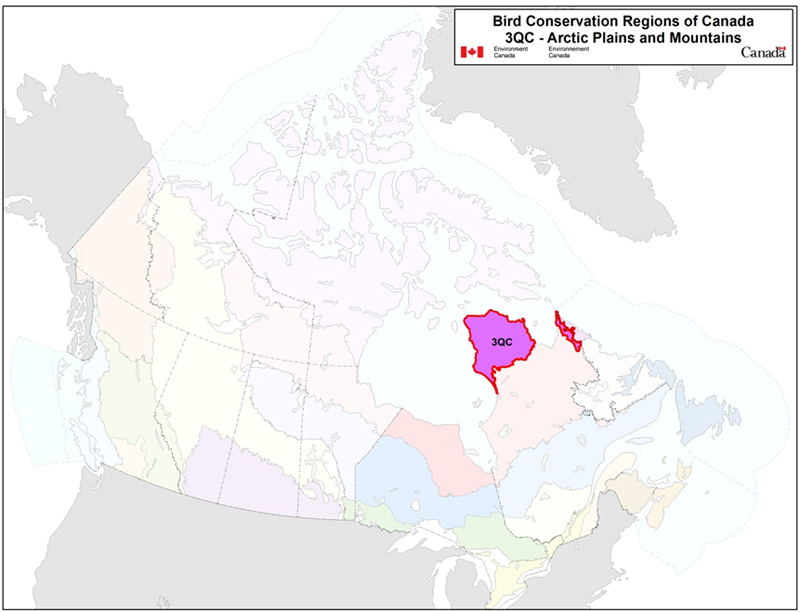
Long description for Map
Map of the Bird Conservation Regions (BCRs) of Canada with BCR 3, Quebec: Arctic Plains and Mountains highlighted. The extent of the map includes Canada, with Alaska, Greenland and the northern portion of the U.S. also appearing. The map is divided by BCR (12 Canadian BCRs in total), with various colours, and their exact locations and sizes are indistinguishable, aside from BCR 3.
The highlighted BCR 3 QC covers two areas of northern Quebec: the Ungava Peninsula, stretching from Hudson Bay in the west to Ungava Bay in the east, and including the northern Hudson Strait coast, and the extreme northeastern part of the province bordering Labrador.
Legend: Bird Conservation Regions of Canada. 3 QC: Arctic Plains and Mountains; Environment and Climate Change Canada logo, and Government of Canada logo.
Executive summary
The Quebec portion of the Arctic Plains and Mountains Bird Conservation Region (BCR 3-QC) extends across the Ungava Peninsula and the mountainous region on the border of Labrador, covering an area of 206 924 km2. The climate is extremely harsh and dry with continuous permafrost. BCR 3-QC is mainly covered by arctic tundra, which includes herbaceous plants, mosses, lichens and dwarf shrubs. The region is also characterized by frequent rocky outcrops and a high density of small and medium-sized lakes. BCR 3-QC is the least populated of Quebec’s BCRs, and its population is predominantly Aboriginal persons. The main human activities are subsistence hunting, trapping and mining. The avifauna of this BCR includes a limited number of species, but some of them do not nest anywhere else in Quebec.
After evaluating 65 bird species found in BCR 3-QC, 25 species were identified as priorities in this BCR. The priority list includes species from the 4 bird groups: landbirds (40%), waterfowl (28%), shorebirds (20%), waterbirds (12%). These priority species include 4 species considered at risk either provincially or federally. Priority species use 7 habitat types in BCR 3-QC. The habitats that attract the most species are shrubs and early successional habitats (36% of priority species), bare areas (32%), riparian areas (28%), wetlands (28%) and coastal areas (24%).
Each priority species was assigned a population objective based on its population trend. Assessing/maintaining populations at current levels was the objective most often assigned to priority species in BCR 3-QC (48% of priority species), while maintaining the population was the objective assigned to 16% of species. Better population trend data are required for all species that have been assigned one of these two objectives. A recovery objective was assigned to 16% of species (all are species at risk), and population increase objectives were also assigned to 20% of priority species. Overall, 36% of priority species identified in BCR 3-QC were assigned a population increase objective.
A threat assessment identified the main conservation issues facing priority species in the various habitats they use within this BCR. Climate change and mining are the main threats reported in BCR 3-QC. The habitats most severely affected, or potentially affected, by these threats are wetlands, coastal areas and riparian areas. The lack of biological or demographic data on the priority species and the presence of species at risk without a finalized recovery strategy or management plan were also considered to be significant conservation issues since they affect all priority species in this BCR.
Conservation objectives have been established to counter threats and fill gaps in our understanding of priority species. The majority of conservation objectives for BCR 3-QC aim to improve bird population monitoring in order to gather the ecological and demographic information that is lacking about all priority species in this BCR.
In order to achieve the established conservation objectives, conservation actions have been recommended for priority species in BCR 3-QC. More than half of the recommended actions relate to population monitoring and include activities such as developing and implementing a long-term program to monitor breeding birds in the Arctic, updating the Waterfowl Survey of Northern Quebec (WNOR) and implementing the Program for Regional and International Shorebird Monitoring (PRISM).
Migratory birds found in BCR 3-QC also face threats that are difficult to analyze with the standardized methodology used in this strategy. These threats include generalized problems that may sometimes not apply to a particular habitat (e.g.collisions with human-made structures, air pollution and climate change), research and population monitoring needs, as well as threats to migratory birds when they are outside Canada. An overview of these issues, the species affected and the recommended conservation actions is also presented.
Introduction: Bird Conservation Strategies
Context
This document is one of a suite of Bird Conservation Region Strategies (BCR strategies) that have been drafted by Environment and Climate Change Canada for all regions of Canada. These strategies respond to Environment and Climate Change Canada’s need for integrated and clearly articulated bird conservation priorities to support the implementation of Canada’s migratory birds program, both domestically and internationally. This suite of strategies builds on existing conservation plans for the four bird groups (waterfowlFootnote1, waterbirdsFootnote2, shorebirdsFootnote3 and landbirdsFootnote4) in most regions of Canada, as well as on national and continental plans, and includes birds under provincial/territorial jurisdiction. These new strategies also establish standard conservation planning methods across Canada and fill gaps, as previous regional plans do not cover all areas of Canada or all bird groups.
These strategies present a compendium of required actions based on the general philosophy of achieving scientifically based desired population levels as promoted by the four pillar initiatives of bird conservation. Desired population levels are not necessarily the same as minimum viable or sustainable populations, but represent the state of the habitat/landscape at a time prior to recent dramatic population declines in many species from threats known and unknown. The threats identified in these strategies were compiled using currently available scientific information and expert opinion. The corresponding conservation objectives and actions will contribute to stabilizing populations at desired levels.
The BCR strategies are not highly prescriptive. In most cases, practitioners will need to consult additional information sources at local scales to provide sufficient detail to implement the recommendations of the strategies. Tools such as beneficial management practices will also be helpful in guiding implementation. Partners interested in participating in the implementation of these strategies, such as those involved in the habitat Joint Ventures established under the North American Waterfowl Management Plan (NAWMP), are familiar with the type of detailed implementation planning required to coordinate and undertake on-the-ground activities.
Strategy structure
Section 1 of this strategy, published here, presents general information about the BCR and the subregion, with an overview of the six elementsFootnote5 that provide a summary of the state of bird conservation at the sub-regional level. Section 2, included in the full strategy, provides more detail on the threats, objectives and actions for priority species grouped by each of the broad habitat types in the subregion. Section 3, also included in the full strategy, presents additional widespread conservation issues that are not specific to a particular habitat or were not captured by the threat assessment for individual species, as well as research and monitoring needs, and threats to migratory birds while they are outside Canada. The approach and methodology are summarized in the appendices of the full strategy, but details are available in a separate document (Kennedy et al. 2012). A national database houses all the underlying information summarized in this strategy and is available from Environment and Climate Change Canada.
Characteristics of Bird Conservation Region 3
The Arctic Plains and Mountains Bird Conservation Region (BCR 3) stretches across northeastern Alaska, the northern edge of the Yukon, the northern part of the Northwest Territories, almost all of Nunavut, the northern tip of Quebec and the portion of Newfoundland and Labrador that is east of Ungava Bay. The Quebec portion of BCR 3 (BCR 3-QC) covers the Ungava Peninsula and the mountainous region bordering Labrador (Fig. 1), totalling an area of 206 924 km2.
Figure 1: Landcover in BCR 3-QC: Arctic Plains and Mountains.
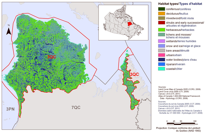
Long description for Figure 1
Map of the landcover in BCR 3, Quebec Region: Arctic Plains and Mountains. The map’s extent includes northern Quebec, northern Labrador and a small part of Nunavut, primarily the southern edges of Baffin Island; the borders of adjoining BCRs are delineated.
The western part of BCR 3 QC, consisting of the Ungava Peninsula from north of Leaf River to the northern coastline, is by far the largest. The eastern part of this BCR extends north-south along the border with Labrador, including the Quebec portion of the Torngat Mountains.
The various habitat types that exist in the BCR are shown on the map, and are explained in the following bilingual legend (appearing to the right of the map):
- Coniferous/conifères
- Deciduous/feuillus
- Mixedwood/forêt mixte
- Shrubs and early successional/arbustes et régénération
- Herbaceous/herbacées
- Cultivated and managed areas/zone cultivées et aménagées
- Lichens and mosses/lichens et mousses
- Wetlands/terres humides
- Alpine/alpin
- Snow and ice/neige et glace
- Bare areas/denude
- Urban/urbain
- Water bodies /plans d’eau
- Riparian/riverain
- Coastal/côtier
The remaining text in the legend provides the data sources for the map (i.e. Land Cover Map of Canada 2005 (CCRS, 2008), the projection of the map (i.e. UTM 9 (NAD 1983)) and there is a visual representation of the scale of the map.
For BCR 3 QC, the most common habitat types are herbaceous vegetation, lichens and mosses, and waterbodies.
Physical environment
Topography
In the portion of BCR 3-QC to the west of Ungava Bay (the Arctic Plain), the terrain is hilly and the altitude gradually increases from west to east, varying for the most part between 0 and 300 m (Li and Ducruc, 1999). This area includes the Puvirnituq mountains, which reach an altitude of 693 m. The eastern portion of the BCR (the Arctic Cordillera) has a more rugged terrain and includes the Torngat Mountains on the border of Labrador. This mountain range includes Mont D’Iberville (the highest peak in Quebec with an altitude of 1652 m), Mont Jacques-Rousseau (1261 m) and Korok Mountain (1204 m; Institut de la Statistique du Québec, 2010). Frequent rocky outcrops and continuous permafrost characterize all of BCR 3-QC.
Hydrography and hydrology
The water system of the western portion of BCR 3-QC includes several major rivers such as the Leaf, Arnaud, Puvirnituq, Kogaluc and Kovik Rivers. There are also countless small and medium-sized lakes and several large lakes including Payne Lake (513 km2), Lake Nantais (266 km2), Lac Faribault (248 km2) and Lac Tasiat (206 km2; Government of Quebec, 2002). The water system of the eastern part of the BCR is not extensive, and the lakes there are few and small (Li and Ducruc, 1999).
Climate
The climate of BCR 3-QC is extremely harsh and dry with an average annual temperature of -8.5 to -6° C. The average summer temperature varies between 3 and 4° C, while the average winter temperature varies between -20 and -16.5° C. In the northern part of the BCR, coastal ice remains long into the summer and the coldest winter temperatures can reach -50°C. The average annual precipitation is 200 to 300 mm in the northern part of the BCR, 400 to 500 mm further south and 400 to 700 mm in the eastern part of the region (Ecological Stratification Working Group, 1996). BCR 3-QC runs a high risk of being affected by climate change in the decades to come. It is expected that by 2050, northern Quebec will see an increase in average annual temperature of 2 to 4.5° C and an increase in precipitation of up to 32% (adapted from Bourque and Simonet, 2008).
Land use
BCR 3-QC is mostly covered by arctic tundra and is dominated by herbaceous plants as well as lichens and mosses, which cover 56% and 23% of the region's area respectively (Fig. 1). The countless waterbodies located in the BCR cover 14% of the area. Most of the land in the BCR is public land (Drolet et al. 2010), while the main human activities are subsistence hunting, trapping and mining (Ecological Stratification Working Group, 1996). BCR 3-QC is part of the area covered by the Government of Quebec’s Northern Initiative, which aims to sustainably develop the economic potential of Northern Quebec. The economic sectors targeted by this initiative in BCR 3-QC include mining, energy and tourism (Gouvernement du Québec 2013). The Government of Quebec is committed to allocating 50% of the northern development area to protect the environment, preserve biodiversity, and evaluate natural heritage. The implementation of this initiative could possibly change the face of BCR 3-QC.
Biological environment
Vegetation
BCR 3-QC is covered by two vegetation sub-zones: forested tundra in the southern part of the BCR (representing < 1% of the area) and the Low Arctic in the rest of the region (Ministère des Ressources naturelles, 2013). The forested tundra, which coincides with the tree line, separates the boreal zone from the Arctic zone. The landscape here is dominated by shrubby heathland dotted with groves of stunted black spruce.
Plant growth in the Low Arctic is restricted by harsh weather conditions and continuous permafrost. Two types of vegetation represent this sub-zone in BCR 3-QC: shrub tundra in most of the BCR and herbaceous tundra at the northernmost part of the region. The shrub tundra is characterized by vegetation cover that generally does not exceed two metres in height, consisting of shrubs (e.g.swamp birch and various species of willow), herbaceous plants (mostly grasses), and mosses and lichens. In the herbaceous tundra, rock and mineral soil are often bare and shrubs are scarce, with vegetation dominated by sedges and grasses among the mosses and lichens.
Wildlife
Severe weather conditions in BCR 3-QC limit the number of animal species that breed and feed there. Mammals found in this area include Woodland Caribou (tundra ecotype), Arctic Hare, Ungava Collared Lemming, Arctic Fox and Gray Wolf. The Wolverine, listed as Threatened in Quebec and Endangered in Canada, and the Polar Bear, listed as Vulnerable in Quebec and Special Concern in Canada, are other mammals characteristic of BCR 3-QC (Ministère du Développement durable, de l’Environnement, de la Faune et des Parcs, 2013; Species at Risk Public Registry, 2012). Fish species found in this area include the Arctic Char, the Lake Whitefish, the Lake Trout and the Atlantic Salmon (Li and Ducruc, 1999). BCR 3-QC is not home to any amphibians or reptiles.
The avifauna of BCR 3-QC numbers only 65 species, but some of them do not nest anywhere else in Quebec or only in low abundance just south of the BCR. These include the Snowy Owl, the Northern Wheatear, the Snow Bunting, the Lapland Longspur, the King Eider, the Common Eider, the Tundra Swan and the American Golden Plover (Aubry and Cotter, 2007; Drolet et al. 2010; Lepage et al. in preparation). Other species characteristic of BCR 3-QC include the Snow Goose, the Long-tailed Duck, the Gyrfalcon, the Rough-legged Hawk, the Semipalmated Plover, the Dunlin and the Thick-billed Murre.
Human environment
BCR 3-QC is the least populated of Quebec’s BCRs. It has about 7500 inhabitants (adapted from Statistics Canada, 2012), who are predominantly Aboriginal (Inuit) and spread across nine communities. The largest communities are Puvirnituq (1700 inhabitants), Inukjuak (1600) and Salluit (1350).
Protected and designated areas
Approximately 12% of the land in BCR 3-QC has protected area status (Fig. 2). It contains two of Quebec’s national parks (operated by the Ministère du Développement durable, de l’Environnement, de la Faune et des Parcs), the Parc national des Pingualuit and the Parc national Kuururjuaq, which together cover a total area of 5594 km2. BCR 3-QC also includes all of Quebec’s Monts-de-Puvirnituq and Cap-Wolstenholme national park reserves and 51% of the Baie-aux-Feuilles national park reserve. These reserves together cover an area of 6408 km2. Other protected areas included in this BCR are five proposed biodiversity reserves (operated by the Ministère du Développement durable, de l’Environnement, de la Faune et des Parcs), which together cover an area of 7406 km2.
Finally, BCR 3-QC also includes designated areas that do not have legal protection status. There are eight Important Bird Areas (IBA) that together cover an area of 4345 km2, some of which partly include the proposed biodiversity reserves.
Figure 2: Map of protected areas in BCR 3-QC: Arctic Plains and Mountains.
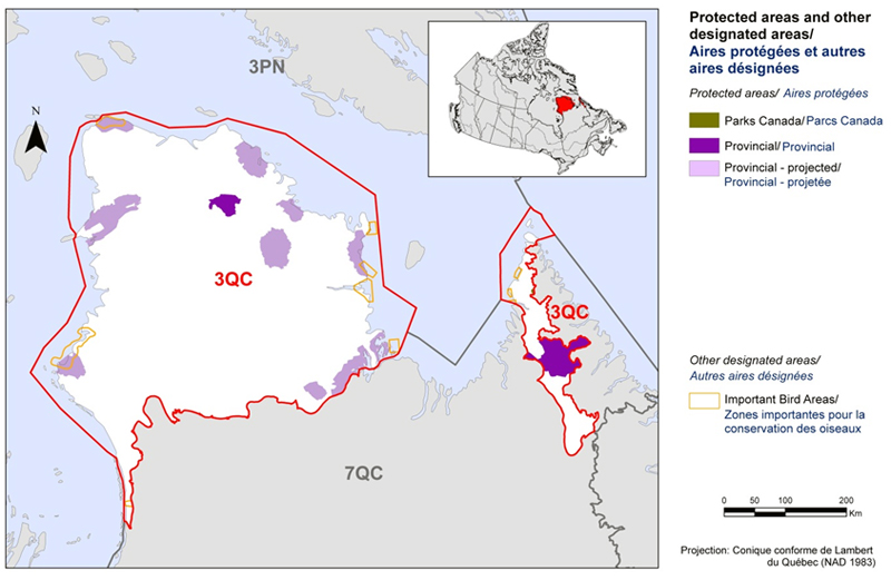
Long description for Figure 2
Map of protected and other designated areas in BCR 3, Quebec Region: Arctic Plains and Mountains. The map’s extent includes northern Quebec, northern Labrador and a small part of Nunavut, primarily the southern edges of Baffin Island. The borders of adjoining BCRs are delineated. The western part of BCR 3 QC, consisting of the Ungava Peninsula from north of Leaf River to the northern coastline, is by far the largest. The eastern part of this BCR extends north-south along the border with Labrador, including the Quebec portion of the Torngat Mountains.
The various types of protected areas that exist in the BCR are shown on the map, and are explained in the following bilingual legend (appearing to the right of the map):
Protected and other designated areas/Aires protégées et autres aires désignées.
Protected areas/Aires protégées
- Parks Canada/Parcs Canada
- Provincial/Provincial
- Provincial-projected/Provincial-projetée
Two provincial parks, along with a number of provincial reserves and proposed biodiversity reserves, are visible. There are also several Important Bird Areas throughout.
Section 1: Summary of results - All Birds, All Habitats
Element 1: Priority species assessment
These Bird Conservation Strategies identify priority species from all regularly occurring bird species in each BCR subregion. Species that are vulnerable due to population size, distribution, population trend, abundance and threats are included because of their conservation concern. Some widely distributed and abundant stewardship species are also included. Stewardship species are included because they typify the national or regional avifauna and/or because they have a large proportion of their range and/or continental population in the subregion; many of these species have some conservation concern, while others may not require specific conservation effort at this time. Species of management concern are also included as priority species when they are at (or above) their desired population objectives but require ongoing management because of their socio-economic importance as game species or because of their impacts on other species or habitats.
The purpose of the prioritization exercise is to focus implementation efforts on the issues of greatest significance for Canadian avifauna. Table 1 provides a full list of all priority species and their reason for inclusion. Tables 2 and 3 summarize the number of priority species in BCR 3-QC by bird group and by the reason for priority status.
The standard method for selecting priority species was used to identify 29 priority species, sub-species or populations (hereinafter referred to as “species”) on a preliminary basis, among the 65 species found in BCR 3-QC. Regional experts reviewed the preliminary list and excluded 7 pre-selected species while adding 3 others, so that 25 priority species were included on the final list (Table 1).
The 25 priority species identified are not distributed equally among the 4 bird groups. Landbirds are the most highly represented group with 10 species or 40% of all priority species in BCR 3-QC (Table 2). This is a representative picture of the importance of landbirds in the region, as they account for 34% of all bird species. Fifty percent of shorebirds (5 species), 21% of waterbirds (3 species) and 37% of waterfowl (7 species) found in BCR 3-QC were designated as priority species.
Nearly half of the priority species (48%) were identified for conservation reasons (Table 1, shaded cells). They include 4 species at risk, either provincially under Quebec’s Loi sur les espèces menacées ou vulnérables [Act respecting threatened or vulnerable species] or nationally under the Species at Risk Act (SARA). Three are species at risk at the provincial and national levels (the Red Knot (rufa), the Peregrine Falcon (anatum/tundrius) and the Short-eared Owl), while a fourth is considered endangered only at the provincial level (the Golden Eagle). Apart from the conservation concern species, 13 have been identified as priority species for stewardship reasons (Table 1; unshaded cells).
Table 1: Priority species in BCR 3-QC, population objective and the reason for priority status. Accessible Version of Table 1.
| Bird Group | Total Species | Total Priority Species | Percent Listed as Priority | Percent of Priority List |
|---|---|---|---|---|
| Landbird | 22 | 10 | 45 % | 40 % |
| Shorebird | 10 | 5 | 50 % | 20 % |
| Waterbird | 14 | 3 | 21 % | 12 % |
| Waterfowl | 19 | 7 | 37 % | 28 % |
| Total | 65 | 25 | 38 % | 100 % |
| Reason for Priority Listinga | Landbirds | Shorebirds | Waterbirds | Waterfowl |
|---|---|---|---|---|
| COSEWICb | 2 | 1 | 0 | 0 |
| Federal SARA listedc | 2 | 1 | 0 | 0 |
| Provincially listedd | 3 | 1 | 0 | 0 |
| National/Continental Concerne | 5 | - | - | - |
| Regional Concerne | 0 | - | - | - |
| National/Continental Stewardshipe | 7 | - | - | - |
| Regional Stewardshipe | 5 | - | - | - |
| Conservation categoryf | - | 5 | - | - |
| Priority levelg | - | - | 3 | - |
| NAWMPh | - | - | - | 4 |
| Expert reviewi | 0 | 0 | 0 | 3 |
a A single species can be on the priority list for more than one reason. Note that not all reasons for inclusion apply to every bird group (indicated by “-”).
b COSEWIC indicates species assessed by the Committee on the Status of Endangered Wildlife in Canada as Endangered, Threatened, or Special Concern.
c Species listed on Schedule 1 of the Species at Risk Act as Endangered, Threatened, or Special Concern.
d Provincially Listed indicates species listed as Threatened, Vulnerable or Likely to be designated as threatened or vulnerable under the Loi sur les espèces menacées ou vulnérables(Quebec).
e See Table 1.
f Conservation category indicates a species ranked in Canada’s Shorebird Conservation Plan (Donaldson et al., 2000) as having a 5, 4a, 4b or 3a conservation category in the United States of America and Canada.
g Priority level indicate a species ranked in Canada’s Waterbird Conservation Plan (Milko et al., 2003) as belonging to Tier 1 or Tier 2.
h NAWMP indicates a species ranked in the North American Waterfowl Management Plan (Plan Committee, 2004) as having Moderately High, High or Highest breeding or non-breeding conservation and/or monitoring needs in the BCR.
i NAWMP Plan Committee 2004.
Element 2: Habitats important to priority species
Identifying the broad habitat requirements for each priority species within the BCR allowed species to be grouped by shared habitat-based conservation issues and actions. If many priority species associated with the same habitat face similar conservation issues, then conservation action in that habitat may support populations of several priority species. BCR strategies use a modified version of the standard land cover classes developed by the United Nations (Food and Agriculture Organization 2000) to categorize habitats, and species were often assigned to more than one habitat class.
Priority species use seven habitat types in BCR 3-QC (Fig. 3). Although it only represents 0.2% of the BCR land area, the shrub and early successional habitat class is used by the largest number of priority species (nine species, all landbirds), representing 36% of all priority species. The bare areas habitat class is also marginal in terms of the area it covers in the BCR (less than 0.01%), but is still used by eight priority species (32%), all landbirds.
The riparian and wetlands habitat classes both rank as the third most-used habitat class by priority species (each used by seven species, or 28% of priority species). These two habitat types are mostly used by shorebirds and waterfowl.
The other habitat types used by priority species are coastal areas (used by 24% of priority species), waterbodies (16%) and herbaceous areas (4%). Coastal areas are used by all bird groups with the exception of landbirds, while waterbodies are used by waterbirds and one waterfowl species. The herbaceous habitat category is used by a single priority species, the American Golden Plover, despite being the largest habitat in this BCR, occupying 56% of the area.
See Section 2 of the full strategy for more details on priority species, threats and conservation actions for each habitat type in BCR 3-QC.
Figure 3: Percent of priority species that are associated with each habitat type in BCR 3-QC.
Note: The total exceeds 100% because each species may be assigned to more than one habitat.
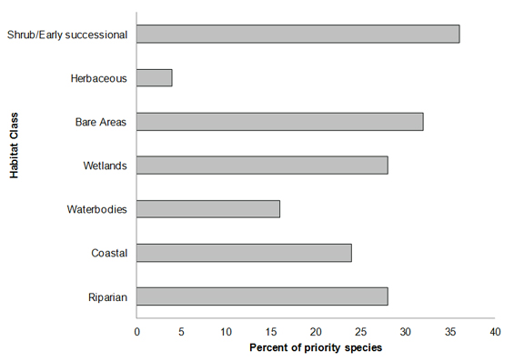
Long description for Figure 3
A horizontal bar graph indicating the percent of priority species (x axis) that are associated with each habitat type (y axis: shrub/early successional, herbaceous, bare areas, wetlands, waterbodies, coastal, and riparian) in BCR 3 Quebec Region. Note: The total exceeds 100% because each species may be assigned to more than one habitat.
| Habitat Class | Percent |
|---|---|
| Shrub/Early successional | 36 |
| Herbaceous | 4 |
| Bare Areas | 32 |
| Wetlands | 28 |
| Waterbodies | 16 |
| Coastal | 24 |
| Riparian | 28 |
Element 3: Population objectives
Population objectives allow us to measure and evaluate conservation success. The objectives in this strategy are assigned to categories and are based on a quantitative or qualitative assessment of species’ population trends. If the population trend of a species is unknown, the objective is set as “assess and maintain”, and a monitoring objective is given. For any species listed under the Species at Risk Act (SARA) or under provincial/territorial endangered species legislation, Bird Conservation Strategies defer to population objectives in available Recovery Strategies and Management Plans. The ultimate measure of conservation success will be the extent to which population objectives have been reached over the next 40 years. Population objectives do not currently factor in feasibility of achievement, but are held as a standard against which to measure progress.
“Assess/Maintain” was the objective assigned to the greatest number of priority species in BCR 3-QC (48% of priority species; Fig. 4). For all species with this objective, there is a lack of the biological or demographic information required for proper population management. This is also the case for species that have been assigned the objective of maintaining populations at their current level (16% of priority species).
A recovery objective was assigned to 16% of priority species, reflecting the proportion of priority species in BCR 3-QC that are listed in Appendix 1 of SARA or that have a status of Threatened or Vulnerable according to Quebec’s Act respecting threatened or vulnerable species. In addition to these recovery objectives, which all seek to increase populations at risk, population increase objectives were also assigned to 20% of priority species under the categories “Increase,” “Increase 50%” and “Increase 100%.” Overall, 36% of priority species identified in BCR 3-QC were assigned a population increase objective.
Figure 4: Percent of priority species that are associated with each population objective category in BCR 3-QC.
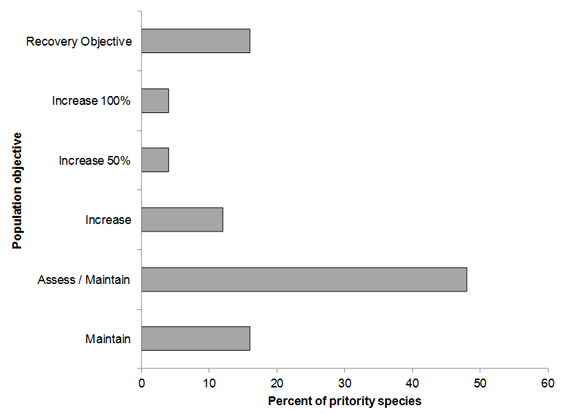
Long description for Figure 4
A horizontal bar graph indicating the percent of priority species (x axis) that are associated with each population objective (y axis; recovery objective, increase 100%, increase 50%, increase, assess/maintain, maintain) in BCR 3 Quebec Region.
| Population Objective | Percent |
|---|---|
| Recovery Objective | 16 |
| Increase 100% | 4 |
| Increase 50% | 4 |
| Increase | 12 |
| Assess / Maintain | 48 |
| Maintain | 16 |
Element 4: Threat assessment for priority species
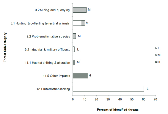
The threats assessment process identifies threats believed to have a population-level effect on individual priority species. These threats are assigned a relative magnitude (Low, Medium, High, Very High), based on their scope (the proportion of the species’ range within the subregion that is impacted) and severity (the relative impact on the priority species’ population). This allows us to target conservation actions towards threats with the greatest effects on suites of species or in broad habitat classes. Some well-known conservation issues (such as predation by domestic cats or climate change) may not be identified in the literature as significant threats to populations of an individual priority species and therefore may not be captured in the threat assessment. However, they merit attention in conservation strategies because of the large numbers of individual birds affected in many regions of Canada. We have incorporated them in a separate section on Widespread Issues, but, unlike other threats, they are not ranked.
A total of 78 threats classified into 6 categories and 7 sub-categories have been identified and are summarized in Fig. 5. Category “12. Other direct threats,” represented by sub-category “12.1 Information lacking”, is the category most frequently associated with priority species in BRC 3-QC, with 60% of all identified threats and a “Low” overall relative magnitude (Table 4). This category is composed of elements relating to the lack of biological or demographic information required for appropriate population management. Its magnitude is also attributable to the presence of species at risk for which there are no finalized recovery strategies or management plans. Only 1 of the 4 species at risk in BCR 3-QC had a finalized recovery strategy when this document was written. The need for more information was raised for all 25 priority species in BCR 3-QC.
The category “11. Climate change and severe weather” ranks second for the percentage of threats affecting priority species in BCR 3-QC, with 14% of all threats. This category, with a “High” overall relative magnitude (Table 4), is essentially represented by the sub-category “11.5 Other impacts,” which includes the higher frequency of adverse weather events as a threat that may affect migration, reproductive success, nesting phenology and prey availability (Fig. 5).
The category “3. Energy production and mining” includes 12% of all identified threats and has a “Medium” overall relative magnitude (Table 4). This category is represented by the sub-category “3.2 Mining and quarrying”, whose only threat is habitat loss and degradation due to mining projects.
The sub-category “5.1 Hunting and collecting terrestrial animals” includes 10% of all identified threats and is the only one in category “5. Biological resource use” whose overall relative magnitude is “Low” (Table 4). The only threat included in this sub-category is the lack of knowledge about the extent of subsistence hunting and its impact on bird populations.
The sub-category “8.2 Problematic native species” represents only 3% of the threats in BCR 3-QC (Fig. 5). The only threat associated with this sub-category and, in turn, with category “8. Invasive and other problematic species and genes” as a whole, is related to outbreaks of avian cholera. Category 8 has a “Low” overall relative magnitude for BCR 3-QC (Table 4).
Finally, category “9. Pollution” includes only 1% of identified threats and has a “Low” overall relative magnitude (Table 4). The only sub-category present in this category is “9.2 Industrial and military effluents” and includes the threat of oil spills (Fig. 5).
Of the seven major habitat classes in BCR 3-QC, three are affected by an overall relative threat magnitude of “Medium”: wetlands, coastal areas and riparian areas (Table 4). Coastal areas are affected by the six threat categories in this BCR and face threats with a relative magnitude of “High” due to climate change and severe weather (category 11). This threat category also affects wetlands (“High” relative magnitude) and riparian areas (“Medium” relative magnitude). These three habitat classes are also affected by energy production and mining (category 3), with a relative magnitude of “Medium”. The threats to other habitat classes in BCR 3-QC are assigned a “Low” overall relative magnitude.
Section 2 of the full version of the strategy presents more detailed information on threats by habitat category. Threats to priority species while they are outside Canada during the non-breeding season were also assessed and are presented in the section entitled Threats Outside Canada in the full version of the strategy.
Figure 5: Percent of identified threats to priority species within BCR 3-QC by threat sub-category.
Each bar represents the percent of the total number of threats identified in each threat sub-category in BCR 3-QC (for example, if 100 threats were identified in total for all priority species in BCR 3-QC, and 10 of those threats were in the category 1.1 Housing and urban areas, the bar on the graph would represent this as 10%). Shading in the bars (VH = very high, H = high, M = medium and L = low) represents the rolled-up magnitude of all threats in each threat sub-category in the BCR.
Long description for Figure 5
A horizontal bar graph indicating the percent of identified threats to priority species (x axis) within BCR 3 Quebec Region by threat subcategory (y axis; Mining and quarrying, Habitat shifting and alteration, etc.).
Each bar represents the percent of the total number of threats identified in each sub-threat category in BCR 3 (for example, if 100 threats were identified in total for all priority species in BCR 3, and 10 of those threats were in the category 1.1 “Housing and urban areas”, the bar on the graph would represent this as 10%). Shading in the bars (VH = very high, H = high, M = medium and L = low) represents the rolled-up magnitude of all threats in each threat subcategory in the BCR.
| Threat Sub-category | L | M | H | VH |
|---|---|---|---|---|
| 3.2 Mining and quarrying | 0 | 12 | 0 | |
| 5.1 Hunting and collecting terrestrial animals | 8 | 3 | 0 | |
| 8.2 Problematic native species | 0 | 3 | 0 | |
| 9.2 Industrial and military effluents | 1 | 0 | 0 | |
| 11.1 Habitat shifting and alteration | 0 | 0 | 1 | |
| 11.5 Other impacts | 0 | 0 | 13 | |
| 12.1 Information lacking | 60 | 0 | 0 |
| Threat category | Habitat Class Shrub/Early successional |
Habitat Class Herbaceous |
Habitat Class Bare areas |
Habitat Class Wetlands |
Habitat Class Waterbodies |
Habitat Class Coastal |
Habitat Class Riparian |
Habitat Class Overall |
|---|---|---|---|---|---|---|---|---|
| Overall | L | L | L | M | L | M | M | |
| 3. Energy production and mining | L | M | M | M | M | |||
| 5. Biological resource use | L | M | L | |||||
| 8. Invasive and other problematic species and genes | M | L | ||||||
| 9. Pollution | L | L | ||||||
| 11. Climate change and severe weather | M | H | H | M | H | |||
| 12. Other direct threats | L | L | L | L | L | L | L | L |
Element 5: Conservation objectives
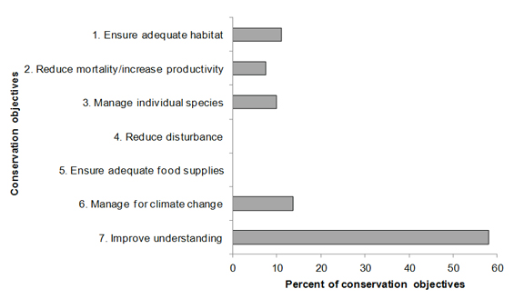
Conservation objectives were designed to address threats and information gaps that were identified for priority species. They describe the environmental conditions and research and monitoring that are thought to be necessary for progress towards population objectives and to understand underlying conservation issues for priority bird species. As conservation objectives are reached, they will collectively contribute to achieving population objectives. Whenever possible, conservation objectives were developed to benefit multiple species and/or respond to more than one threat.
Conservation objectives have been divided into the seven categories presented in Fig. 6. In BCR 3-QC, 58% of suggested conservation objectives are in the category “7. Improve understanding” (of population status, limiting factors and mitigation). Most of the objectives in this category are from sub-category “7.1 Improve population/demographic monitoring”, while the other objectives are associated with the sub-category “7.2 Improve harvest monitoring.” This demonstrates a need for increased monitoring of priority species in this BCR.
Objective “6. Manage for climate change” ranks second with 14% of all suggested conservation objectives and has only one sub-category, “6.2 Manage for habitat resilience as climate changes.”
For 11% of the objectives, the goal is to ensure adequate habitat (category 1). This objective category contains only one sub-category, “1.1 Ensure land and resource-use policies and practices maintain or improve bird habitat,” and concerns herbaceous areas, wetlands, coastal areas and riparian areas.
The objective “3. Manage individual species” accounts for 10% of all objectives raised for BCR 3-QC. All objectives in this category come from the sub-category “3.4 Implement recovery strategies for species at risk.”
Finally, objective “2. Reduce mortality/increase productivity” represents 7% of the suggested conservation objectives and consists of sub-categories “2.3 Reduce mortality and/or sub-lethal effects of oil pollution” and “2.6 Reduce the spread of disease.” No objectives have been assigned to categories “4. Reduce disturbance” and “5. Ensure adequate food supplies” in BCR 3-QC.
Figure 6: Percent of all conservation objectives assigned to each conservation objective category in BCR 3-QC.
Note: Objective “7. Improve understanding” in this case indicates improving our understanding of population status, limiting factors and mitigation.
Long description for Figure 6
A horizontal bar graph indicating the percent of all conservation objectives (x axis) assigned to each conservation objective category (y axis; ensure adequate habitat, reduce disturbance, etc.) in BCR 3 Quebec Region.
| Conservation Objective | Percent |
|---|---|
| 1. Ensure adequate habitat | 11 |
| 2. Reduce mortality/increase productivity | 7 |
| 3. Manage individual species | 10 |
| 4. Reduce disturbance | 0 |
| 5. Ensure adequate food supplies | 0 |
| 6. Manage for climate change | 14 |
| 7. Improve understanding | 58 |
Element 6: Recommended actions
Recommended actions indicate on-the-ground activities that will help to achieve the conservation objectives (Fig. 7). Actions are strategic rather than highly detailed and prescriptive. Whenever possible, recommended actions benefit multiple species and/or respond to more than one threat. Recommended actions defer to or support those provided in recovery documents for species at risk at the federal, provincial or territorial level, but will usually be more general than those developed for individual species.
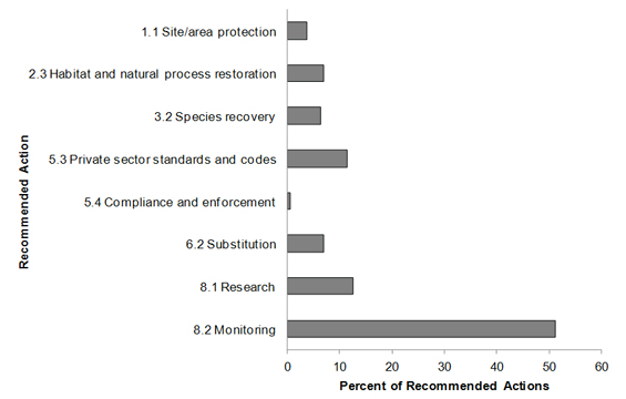
Figure 7 shows that 51% of the actions recommended in BCR 3-QC are in sub-category “8.2 Monitoring.” The high frequency of this recommendation is primarily due to the lack of biological or demographic information on all priority species in the BCR. The actions suggested in this category include developing and implementing a long-term program to monitor breeding birds in the Arctic, maintaining the current Canada Geese (Atlantic population) banding program and expanding it to include other priority species of waterfowl in the BCR, updating the Waterfowl Survey of Northern Quebec, implementing the protocol for the Program for Regional and International Shorebird Monitoring (PRISM), and including landbirds. For more details, please refer to Section 3 in the full version of the strategy.
Sub-category “8.1 Research” is the second largest, with 13% of all recommended actions. This sub-category is also linked to the lack of information on priority species in BCR 3-QC and includes an action designed to develop research projects to fill gaps in knowledge about the impacts of climate change on Low Arctic birds. Another recommended action in this sub-category is to develop research projects to fill gaps in knowledge about the relationships among duck breeding, moulting and wintering sites, in order to distinguish among the various populations.
Sub-category “5.3 Private sector standards and codes” concerns the mining sector and includes 11% of all suggested conservation actions. The actions recommended consist of encouraging the adoption of more environmentally friendly practices and implementing the mitigation and prevention actions identified in project environmental assessments.
Sub-categories “2.3 Habitat and natural process restoration” and “6.2 Substitution” each represent 7% of the recommended actions. Sub-category 2.3 particularly affects wetlands and coastal areas and mainly concerns habitat restoration after site operations have ceased. The only action recommended in sub-category 6.2 is to promote the reduction of greenhouse gas emissions.
Species recovery (3.2) includes 6% of the recommended actions and mainly concerns the development and implementation of recovery strategies or management plans for species at risk.
Site/area protection (1.1) includes 4% of suggested conservation actions and concerns wetlands, coastal areas and riparian areas. The actions recommended in this sub-category aim to protect habitat (e.g. important nesting and roosting sites) by granting legal conservation or stewardship status to minimize the impact of threats from the mining sector.
Finally, sub-category “5.4 Compliance and enforcement” represents only 1% of the recommended actions and consists of preventing the discharge of oily ship waste into the ocean by promoting compliance with federal legislation.
More details on recommended actions for the various habitat classes are presented in Section 2 of the full version of the strategy.
Figure 7: Percent of recommended actions assigned to each sub-category in BCR 3-QC.
Sub-categories “8.1 Research” and “8.2 Monitoring” refer to specific species where more information is required before conservation actions can be formulated. For a discussion of broad-scale research and monitoring requirements, see the section entitled Research and Population Monitoring Needs in the full version of the strategy.
Long description for Figure 7
A horizontal bar graph indicating the percent of recommended action (x axis) assigned to each sub-category of recommended actions (y axis; Site/area protection, Species recovery, etc.) in BCR 3 Quebec Region.
| Conservation Action | Percent |
|---|---|
| 1.1 Site/area protection | 4 |
| 2.3 Habitat and natural process restoration | 7 |
| 3.2 Species recovery | 6 |
| 5.3 Private sector standards and codes | 11 |
| 5.4 Compliance and enforcement | 1 |
| 6.2 Substitution | 7 |
| 8.1 Research | 13 |
| 8.2 Monitoring | 51 |
References
Aubry, Y. and R. Cotter. 2007. Québec Shorebird Conservation Plan. Environment and Climate Change Canada, Canadian Wildlife Service, Quebec region, Sainte-Foy, xvi + 203 p.
Bourque, A. and G. Simonet. 2008. “Quebec”, in From Impacts to Adaptation: Canada in a Changing Climate 2007 (PDF; 337 Kb), edited by D.S. Lemmen, F.J. Warren, J. Lacroix and E. Bush. Government of Canada, Ottawa, ON, pp. 171-226.
Chapdelaine, G. and J.-F. Rail. 2004. Québec’s Waterbird Conservation Plan (PDF; 174 Mb). Migratory Bird Division, Canadian Wildlife Service, Quebec Region, Environment and Climate Change Canada, Sainte-Foy, Quebec. 99 p.
Donaldson, G. M., C. Hyslop, R. I. G. Morrison, H. L. Dickson, and I. Davidson (editors). 2000. Canadian Shorebird Conservation Plan. Canadian Wildlife Service, Environment and Climate Change Canada, Ottawa, Ontario. 27pp.
Drolet, B., V. Carignan, M.-A. Vaillancourt and G. Falardeau. 2010. Plan de conservation des oiseaux terrestres du Québec : volume 1, oiseaux des milieux forestiers. Unpublished working document, Environment and Climate Change Canada, Canadian Wildlife Service, Quebec Region.
Ecological Stratification Working Group. 1996. A National Ecological Framework for Canada. Agriculture and Agri-Food Canada, Research Branch, Centre for Land and Biological Resources Research and Environment and Climate Change Canada, State of the Environment Directorate, Ecozone Analysis Branch, Ottawa/Hull. Report and national map at 1:7500 000 scale.
Falardeau, G., V. Carignan, B. Drolet and M.-A. Vaillancourt. 2010. Plan de conservation des oiseaux terrestres du Québec, volume 2 : les oiseaux des milieux agricoles, humides, urbains, arctiques, alpins et des falaises. Unpublished working document, Environment and Climate Change Canada, Canadian Wildlife Service, Quebec Region.
Food and Agriculture Organization (FAO). 2000. Land cover classification system. United Nations Food and Agriculture Organization, Rome.
Gouvernement du Québec. 2013., Le Nord pour tous. (Accessed 21 October 2013).
Institut de la Statistique du Québec. 2010. Principaux sommets, par région administrative et selon la chaîne de montagnes, Québec. (Accessed 10 June 2013). (in French only)
Kennedy, J.A., E.A. Krebs and A.F. Camfield. 2012. A Manual for Completing All-bird Conservation Plans in Canada, April 2012 version. Canadian Wildlife Service, Environment and Climate Change Canada. Ottawa, Ontario.
Lepage, C., D. Bordage, D. Dauphin, F. Bolduc and B. Audet. In preparation. Quebec Waterfowl Conservation Plan, 2010. Environment and Climate Change Canada, Canadian Wildlife Service, Quebec region, Quebec City.
Li, T. and J.-P. Ducruc. 1999. Les provinces naturelles. Niveau I du cadre écologique de référence du Québec. Ministère de l’Environnement. (Accessed 10 October 2012). (in French only)
Milko, R., L. Dickson, R. Elliot, and G. Donaldson. 2003. Wings Over Water: Canada’s Waterbird Conservation Plan. Canadian Wildlife Service, Environment and Climate Change Canada, Ottawa, Ontario. 28pp.
Ministère des Ressources naturelles. 2013. Zones de végétation et domaines bioclimatiques du Québec. (Accessed 28 February 2013). (in French only)
Ministère du Développement durable, de l’Environnement, de la Faune et des Parcs. 2013. Liste des espèces désignées menacées ou vulnérables au Québec. (Accessed 28 February 2013). (in French only)
North American Waterfowl Management Plan, Plan Committee. 2004. North American Waterfowl Management Plan 2004. Implementation Framework: Strengthening the Biological Foundation. Canadian Wildlife Service, U.S. Fish and Wildlife Service, Secretaria de Medio Ambiente y Recursos Naturales, 106 pp.
Panjabi, A. O., E. H. Dunn, P. J. Blancher, W. C. Hunter, B. Altman, J. Bart, C. J. Beardmore, H. Berlanga, G. S. Butcher, S. K. Davis, D. W. Demarest, R. Dettmers, W. Easton, H. Gomez de Silva Garza, E. E. Iñigo-Elias, D. N. Pashley, C. J. Ralph, T. D. Rich, K. V. Rosenberg, C. M. Rustay, J. M. Ruth, J. S. Wendt, and T. C. Will. 2005. The Partners in Flight Handbook on Species Assessment. Version 2005. Partners in Flight Technical Series No. 3. Rocky Mountain Bird Observatory .
Rich, T.D., C.J. Beardmore, H. Berlanga, P.J. Blancher, M.S.W. Bradstreet, G.S. Butcher, D.W. Demarest, E.H. Dunn, W.C. Hunter, E.E. Iñigo-Elias, J.A. Kennedy, A.M. Martell, A.O. Panjabi, D.N. Pashley, K.V. Rosenberg, C.M. Rustay, J.S. Wendt and T.C. Will. 2004. Partners in Flight North American Landbird Conservation Plan. Cornell Lab of Ornithology. Ithaca, New York.
Species at Risk Public Registry. Accessed 13 October 2012. Schedule 1: List of Wildlife Species at Risk.
Statistics Canada. 2012. Population and dwelling counts, for Canada, provinces and territories, and census subdivisions (municipalities), 2011 and 2006 censuses. (Accessed 10 Sept. 2012).