
Bird Conservation Strategy for region 7 in Ontario
- Abridged Version -
August 2013

The abridged version of the strategy available here contains a summary of the results, but does not include an analysis of conservation needs by habitat, a discussion of widespread conservation issues, or the identification of research and monitoring needs.
Other formats available for this document:
Table of contents
- Preface
- Acknowledgements
- Bird Conservation Strategy for BCR 7 in Ontario: Taiga Shield and Hudson Plains
- Executive summary
- Introduction: Bird Conservation Strategies
- Section 1: Summary of results - All Birds, All Habitats
- References
List of figures
- Figure 1: Map of boundary changes to Ontario’s Bird Conservation Region 7: Taiga Shield and Hudson Plains.
- Figure 2: Map of landcover in BCR 7 Ontario.
- Figure 3: Map of protected and other designated areas in BCR 7 Ontario.
- Figure 4: Percent of priority species that are associated with each habitat type in BCR 7 Ontario.
- Figure 5: Percent of priority species that are associated with each population objective category in BCR 7 Ontario.
- Figure 6: Percent of identified threats to priority species within BCR 7 ON by threat sub-category.
- Figure 7: Percent of all conservation objectives assigned to each conservation objective category in BCR 7 Ontario.
- Figure 8: Percent of recommended actions assigned to each sub-category in BCR 7 Ontario.
List of tables
- Table 1: Major categories of land cover in BCR 7 ON and their proportions on the landscape.
- Table 2: Priority species in BCR 7 Ontario, population objective and reasons for priority status. All assessments, listings and designations are current to February 2013.
- Table 3: Summary of priority species, by bird group, in BCR 7 Ontario.
- Table 4: Number of priority species in BCR 7 ON by reason for priority status. All assessments, listings and designations are current to February 2013.
- Table 5: Relative magnitude of identified threats to priority species within BCR 7 ON by threat category and broad habitat class.
Preface
Environment and Climate Change Canada led the development of bird conservation strategies in each of Canada’s Bird Conservation Regions (BCRs) by drafting new strategies and integrating new and existing strategies into an all-bird framework. These integrated all-bird conservation strategies will serve as a basis for implementing bird conservation across Canada, and will also guide Canadian support for conservation work in other countries important to Canada’s migrant birds. Input to the strategies from Environment and Climate Change Canada’s conservation partners is as essential as their collaboration in implementing their recommendations.
Environment and Climate Change Canada has developed national standards for strategies to ensure consistency of approach across BCRs. Bird Conservation Strategies will provide the context from which specific implementation plans can be developed for each BCR, building on the programs currently in place through Joint Ventures or other partnerships. Landowners including Aboriginal peoples will be consulted prior to implementation.
Conservation objectives and recommended actions in the conservation strategies will be used as the biological basis to develop guidelines and beneficial management practices that support compliance with regulations under the Migratory Birds Convention Act, 1994. Furthermore, these strategies will guide conservation action in support of The State of Canada's Birds 2012 (North American Bird Conservation Initiative Canada 2012), which points to the strong influence of human activity on bird populations, both positive and negative, and presents solutions towards keeping common birds common and restoring populations that are in decline.
Acknowledgements
Brigitte Collins and Paul Smith were the main authors of this document which follows templates developed by Alaine Camfield, Judith Kennedy and Elsie Krebs with the help of the BCR planners in each of Environment and Climate Change Canada’s Canadian Wildlife Service regions throughout Canada. However, work of this scope cannot be accomplished without the contribution of other colleagues and individuals who provided or validated technical information, commented on earlier draft versions of the strategy, provided maps, and supported the overall planning process. We would like to thank the following for their contributions to this strategy: Alaine Camfield, Judith Kennedy and Marie-France Noel from CWS-National Office; Graham Bryan, Mike Cadman, Lesley Davy, Christian Friis, Krista Holmes, Jack Hughes, Shawn Meyer, Michele Rodrick, Daniel Rokitnicki Wojcik, Chris Sharp, Paul Watton, and D.V. Weseloh from CWS-Ontario Region; Sarah Mainguy, North-South Environmental Inc.; and Chris Wedeles, ArborVitae Environmental Services Ltd.
Bird Conservation Strategy for BCR 7 in Ontario: Taiga Shield and Hudson Plains
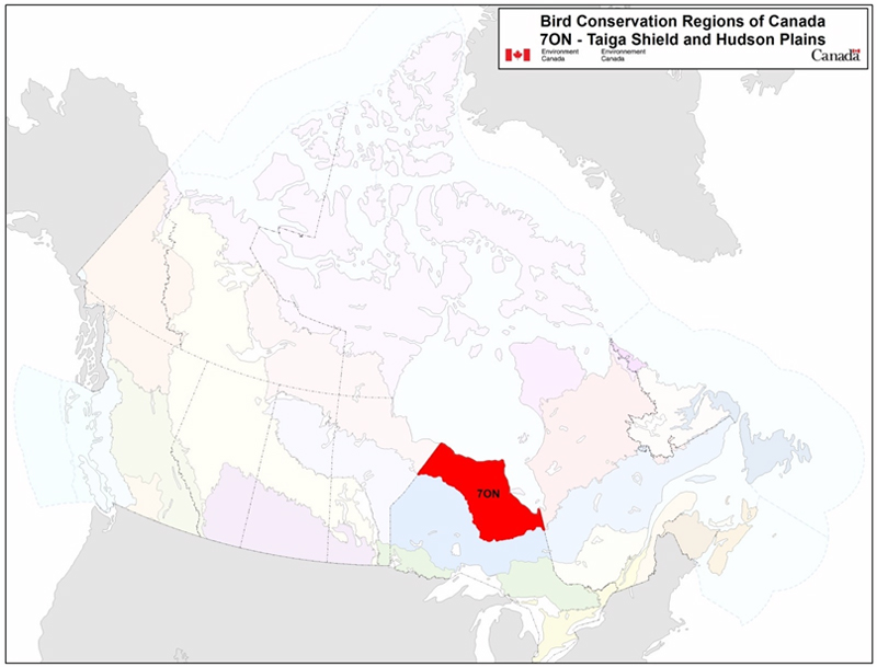
Long description for Map
Map of the Bird Conservation Regions (BCR’s) of Canada with BCR 7, Ontario Region: Taiga Shield and Hudson Plains highlighted in red. Canada (with Alaska, Greenland and the northern portion of the United States of America also appearing, in grey) is shown very washed out, as it is only present to provide context for the location of the highlighted BCR 7. The washed out Canadian map is divided by BCR (12 Canadian BCRs in total), with various colours, and their exact locations and sizes are indistinguishable, aside from BCR 7.
The highlighted BCR 7 covers the breadth of northern Ontario, from the shores of James and Hudson Bay inland (about the same distance from the shores, so the shape of the BCR sub-region roughly mirrors the coast).
The following legend appears in the top right corner of the map: “Bird Conservation Regions of Canada. 7 ON - Taiga Shield and Hudson Plains” and includes the Environment and Climate Change Canada logo, and the Government of Canada logo.
Executive summary
The Taiga Shield and Hudson Plains, Bird Conservation Region 7 (BCR 7), cover almost 260 000 km2 or about 25% of the province of Ontario. Beyond Ontario, BCR 7 extends across roughly 1 700 000 km2 in eight provinces and territories. This immense region shares characteristics with the boreal habitats to the south and the arctic habitats to the north. In Ontario, BCR 7 is dominated by a vast network of marshes, fens and bogs draining across a low-lying plain that skirts Hudson Bay and James Bay.
This conservation strategy for BCR 7 ON builds on existing bird conservation plans and complements those created for the other BCRs across Canada. These strategies will serve as a framework for implementing bird conservation nationally, and also identify international conservation issues for Canada’s priority birds. This strategy is not intended to be prescriptive, but rather is intended to guide future implementation efforts undertaken by various partners and stakeholders.
BCR 7 offers several habitats that are unique in Ontario, including the province’s only marine coastline and the world’s most southerly located mainland tundra. Thirty-five species of Ontario’s breeding birds nest only within the Hudson Bay Lowlands. The rich coastal marshes of Hudson and James Bay are also crucial habitat for millions of waterfowl and shorebirds that stop here to stage before continuing their migrations over continental North America. Indeed, a majority of the bird species present in BCR 7 ON are migratory, and some will travel as far south as South America to their wintering grounds. Consequently, the conservation of birds and their habitats in BCR 7 ON is of critical importance not only for Ontarians, but for countries throughout the Western Hemisphere.
We evaluated 196 bird species that occur in the regionFootnote 1, and 66 were determined to qualify as priority species. All bird groups were represented, with 36% of the priority species list consisting of landbirds, 32% shorebirds, 18% waterfowl and 14% waterbirds. Consistent with the prevalence of wetlands across the landscape, a majority of species (60%) used wetland habitats extensively. In comparison, closed-canopy forest, which is not a dominant habitat type in the region, was used by comparatively few species (18%). Tundra along the Hudson and James Bay coasts was used by one quarter of the priority species in the sub-region (25%).
Population objectives were set on the basis of observed trends, but inadequate monitoring information was a pervasive issue in BCR 7 Ontario. Consequently, nearly 70% of priority species were assigned an objective to “assess” population status while “maintaining” current levels in the interim. For 21% of species, population levels were deemed to be at or near the objective. These results do not imply that bird populations in BCR 7 ON have not changed in abundance in recent decades, but rather that a lack of rigorous monitoring information for the region precludes an assessment of status and assignment of quantitative objectives.
An assessment of threats identified a number of conservation issues facing priority species in the various habitats of BCR 7 Ontario. Consistent with the comparatively natural state of the region, a majority of these threats were considered to have only low magnitude effects on populations. Both the number and magnitude of threats to birds in this region are lower than other BCRs in the province. Exceptions were the high to very high magnitude threats resulting from habitat degradation due to overabundant geese, and the current and projected impacts of climate change. Importantly, mining, renewable energy development and the associated infrastructure were determined to have low magnitude effects at present, but the cumulative effects of these threats may become more significant in the future. For the majority of priority species, a lack of knowledge of population status and limiting factors was a significant impediment to determining their conservation priority.
Actions are recommended to address these conservation issues, and an incomplete understanding of populations’ status meant that knowledge acquisition dominated these actions. Much of this region is difficult to access, and survey coverage is sparse and sporadic. An improved understanding of species’ status and the factors limiting their populations is a prerequisite for effective management of priority birds in this sub-region. Recommendations are provided to address the information gaps.
Much of BCR 7 ON remains in a natural state, and this presents a unique opportunity to pursue future development in the context of conservation, rather than vice versa. The “conservation matrix” approach advocated by Ontario’s Far North Science Advisory panel (Far North Science Advisory Panel 2010) holds significant promise to achieve this. However, achieving conservation successes in this region, through implementation of the recommendations contained within this and other strategies, will require broad collaboration among First Nations, provincial and federal agencies, and a number of other stakeholders.
Introduction: Bird Conservation Strategies
Context
This document is one of a suite of Bird Conservation Region strategies (BCR strategies) that have been drafted by Environment and Climate Change Canada for all regions of Canada. These strategies respond to Environment and Climate Change Canada’s need for integrated and clearly articulated bird conservation priorities to support the implementation of Canada’s migratory birds program, both domestically and internationally. This suite of strategies builds on existing conservation plans for the four “bird groups” (waterfowlFootnote 2, waterbirdsFootnote 3, shorebirdsFootnote 4, and landbirdsFootnote 5) in most regions of Canada, as well as on national and continental plans, and includes birds under provincial/territorial jurisdiction. These new strategies also establish standard conservation planning methods across Canada and fill gaps, as previous regional plans do not cover all areas of Canada or all bird groups.
These strategies present a compendium of required actions based on the general philosophy of achieving scientifically based desired population levels as promoted by the four pillar initiatives of bird conservation. Desired population levels are not necessarily the same as minimum viable or sustainable populations, but represent the state of the habitat/landscape at a time prior to recent dramatic population declines in many species from threats known and unknown. The threats identified in these strategies were compiled using currently available scientific information and expert opinion. The corresponding conservation objectives and actions will contribute to stabilizing populations at desired levels.
The BCR strategies are not highly prescriptive. In most cases, practitioners will need to consult additional information sources at local scales to provide sufficient detail to implement the recommendations of the strategies. Tools such as beneficial management practices will also be helpful in guiding implementation. Partners interested in participating in the implementation of these strategies, such as those involved in the habitat Joint Ventures established under the North American Waterfowl Management Plan (NAWMP), are familiar with the type of detailed implementation planning required to coordinate and undertake on-the-ground activities.
Strategy structure
Section 1 of this strategy, published here, presents general information about the BCR and the sub-region (i.e., Ontario’s portion of the BCR), with an overview of the six elementsFootnote 6that provide a summary of the state of bird conservation at the sub-regional level. Section 2, included in the full strategy, provides more detail on the threats, objectives and actions for priority species grouped by each of the broad habitat types in the sub-region. Section 3, also included in the full strategy, presents additional widespread conservation issues that are not specific to a particular habitat or were not captured by the threat assessment for individual species, as well as research and monitoring needs, and threats to migratory birds while they are outside of Canada. The approach and methodology are summarized in the appendices of the full strategy, but details are available in a separate document (Kennedy et al. 2012). A national database houses all the underlying information summarized in this strategy and is available from Environment and Climate Change Canada.
Characteristics of Bird Conservation Region 7: Taiga Shield and Hudson Plains
The Taiga Shield and Hudson Plains Bird Conservation Region, BCR 7, encompasses an area of more than 1 700 000 km2 and spans eight provinces and territories. This region marks the transition from temperate to arctic habitats, bordered by boreal forests to the south and treeless tundra to the north. With a total area of roughly 260 000 km2 (Table 1), BCR 7 ON covers almost 25% of the province (Fig. 1 and Fig. 2).
Figure 1: Map of boundary changes to Ontario’s Bird Conservation Region 7: Taiga Shield and Hudson Plains.
For conservation planning purposes, the original NABCI-defined boundaries of Ontario BCRs have been updated to be consistent with the Ontario Ministry of Natural Resources Ecodistrict boundaries.
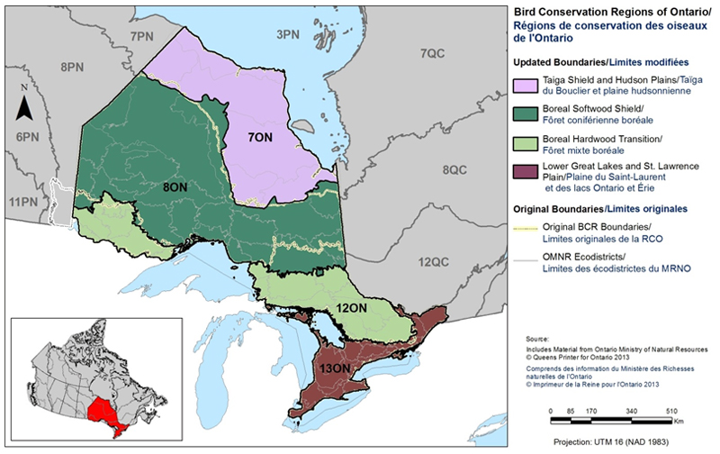
Long description for Figure 1
Map of Ontario with the Bird Conservation Regions and their updated boundaries delineated. BCR 7 (Taiga Shield and Hudson Plains) covers the breadth of northern Ontario, from the shores of James and Hudson Bay inland (the shape of the BCR sub-region roughly mirrors the coast). The boundaries of BCR 8 ON, BCR 12 ON, BCR 13 ON and all other adjacent BCR’s in Quebec and Manitoba are shown for context.
There is a bilingual legend on the right which indicates the ON BCRs (Taiga Shield and Hudson Plains/ Taiga du Bouclier et plaines hudsoniennes, Boreal Softwood Shield / Forêt coniférienne boréale, Boreal Hardwood Transition / Forêt mixte boréale, Lower Great Lakes and St. Lawrence Plain/Plaine du Saint-Laurent et des lacs Ontario et Érie) and the original boundaries (Original BCR Boundaries/Limites originales de la RCO, OMNR Ecodistricts / Limites des écodistrictes du MNRO). The legend also has a visual representation of the scale of the map, it indicates the projection used (UTM 16 NAD 1983) and indicates that the source of the data is the Ontario Ministry of Natural Resources, Queen’s Printer for Ontario 2013 / Ministre des ressources naturelles de l’Ontario, L’imprimeur de la Reine pour l’Ontario.
Figure 2: Map of landcover in BCR 7 Ontario.
Note: Riparian habitat areas are not depicted on this map because they represent a “zone” and are not a true land-cover class. A map depicting the extent of derived riparian areas for illustration purposes can be found in the Riparian section of the full strategy.
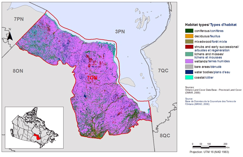
Long description for Figure 2
Map of the landcover in BCR 7 Ontario Region: Taiga Shield and Hudson Plains. The map’s extent includes northern Manitoba, Ontario and western Quebec. The borders of BCR 3PN, 7PN, 7QC, 8ON and 8QC are delineated.
BCR 7 covers the breadth of northern Ontario, from the shores of James and Hudson Bay inland (about the same distance from the shores, so the shape of the BCR sub-region roughly mirrors the coast).
The most common habitat type in BCR 7 ON is by far the wetlands habitat.
The various habitat types that exist in the BCR are shown on the map, and are explained in the following bilingual legend (appearing to the right of the map):
- Coniferous/conifères
- Deciduous/feuillus
- Mixedwood/forêt mixte
- Shrubs and early successional/arbustes et régénération
- Lichens and mosses/lichens et mousses
- Wetlands/terres humides
- Bare areas/denude
- Water bodies /plans d’eau
- Coastal/côtier
The remaining text in the legend provides the data sources for the map (i.e. Land Cover Map of Canada 2005 (CCRS, 2008), the projection of the map (i.e. UTM 16 (NAD 1983)) and there is a visual representation of the scale of the map.
To the east and west, BCR 7 ON is dominated by sparsely treed taiga underlain by the igneous rock of the Canadian Shield. Within Ontario, this BCR is dominated by the low-lying plain skirting the Hudson and James Bay coastlines, a distinct physiographic and ecological region known as the Hudson Bay Lowlands. This plain of impermeable clays was laid down by the shallow sea that covered the area some 6000 years ago, following the most recent glaciation. Over the millennia, peat has accumulated, and this vast and poorly drained plain now supports an immense network of marshes, fens and bogs; the third-largest continuous wetland in the world (Keddy 2000). Physiographic change is ongoing in the region. The rate of uplift since the retreat of the glaciers is the greatest in North America, with some coastal areas emerging from Hudson and James Bays at > 1 m per century (Riley 2003).
At 77% of the total area, wetlands predominate in BCR 7 Ontario, with treed bogs and fens the most common habitat type (Table 1). Sedge fens are extensive along the coast and among coniferous forests in inland areas. Highly productive intertidal marshes are also common along the James and Hudson Bay coasts. Forested habitats are less extensive by comparison; only approximately 10% of BCR 7 ON is closed-canopy forest, with an additional 10% classified as sparse forest. These forests form in better-drained areas, such as palsa plateaus, beach ridges and river corridors. Tundras of lichen and heath are found in drier areas in the north of the region, where permafrost is continuous.
| BCR Habitat Class | Provincial Land-cover (PLC 27) Class(es) | Area (ha) | % of Total Area |
|---|---|---|---|
| Coniferous Forest | Forest - Dense Coniferous | 1 853 509 | 7.14% |
| Deciduous Forest | Forest - Dense Deciduous | 68 885 | 0.27% |
| Mixed Forest | Forest - Dense Mixed | 710 661 | 2.74% |
| Shrub/Early Successional | Forest Depletion - Cuts, Forest Depletion - Burns, Forest - Regenerating Depletion |
534 567 | 2.06% |
| Herbaceous | Agriculture -Pasture/Abandoned Fields | 0 | 0% |
| Lichens/Mosses | Tundra Heath | 291 354 | 1.12% |
| Bare Areas | Sand/Gravel/Mine Tailings, Bedrock |
59 646 | 0.23% |
| Wetlands | Marsh - Inland, Swamp - Deciduous, Swamp - Coniferous,the last column. Fen - Open, Fen - Treed, Bog - Open, Bog - Treed Forest - Sparsea |
19 964 698 | 76.92% |
| Waterbodies | Water - deep clear, Water - shallow/sedimented |
2 198 473 | 8.47% |
| Coastal | Marsh - Intertidal, Marsh - Supertidal, Mudflats |
268 823 | 1.04% |
| Riparianb | Area within 30m of shoreline | 1 044 712 | N/A |
| Other/Unknown | Unknown, Cloud/Shadow, Settlement/Infrastrucuture | 3 337 | 0.01% |
| Total Area | 25 953 953 | 100% |
a Sparse forest land-cover in the Hudson Bay-James Bay Lowland can be broadly interpreted to include bogs with a dense tree cover (Spectranalysis 2004, page 27) and based on expert opinion has been attributed to the BCR Habitat Class of wetlands.
b Riparian areas are not included in the total area because they represent a “zone” and not a true land-cover class. Data source: Spectranalysis Inc., 2004 (Provincial Land-cover 27).
The region is physiographically unique, and with Ontario’s most northerly habitats and only marine coastline, the region also supports a unique component of the province’s biodiversity. Among birds, 35 species breed in Ontario only within the Hudson Bay Lowlands (Far North Science Advisory Panel 2010). This includes primarily arctic-breeding species of shorebirds such as the Dunlin and Semipalmated Sandpiper, and waterfowl such as the Lesser Snow Goose. Some species that also breed in more southerly habitats achieve their highest density in Ontario’s BCR 7.
The rich coastal marshes of Hudson and James Bay provide globally significant habitat for migrants passing to and from their arctic breeding grounds. Millions of waterfowl including Canada Geese, Lesser Snow Geese and Atlantic Brant moult and stage in these marshes. For arctic breeding birds migrating south over continental North America, these habitats represent the final intertidal marine habitats before the Gulf of St. Lawrence or the Atlantic or Pacific coasts. A significant fraction, perhaps most, of the endangered rufa Red Knot population stages along the coast of James Bay prior to undertaking their long-distance migration to South America (Morrison et al. 1980).
The region is also unique for its ecological integrity. BCR 7 ON is sparsely populated, with approximately 12 000 human inhabitants spread among 8 communities (Far North Science Advisory Panel 2010). At present, no all-weather roads link the area to the South. The region holds little potential for commercial forestry or hydrocarbon development (Zhang and Barnes 2007; Far North Science Advisory Panel 2010). While mineral exploration is rapidly intensifying (e.g., Ring of Fire), currently there is a single active mine, the Victor Diamond mine 90 km west of Attawapiskat. A vast majority of the region remains in a natural state; rivers flow unimpeded to the sea and fire, succession, isostatic rebound and other natural drivers of ecological change remain the dominant forces shaping the land-cover. However, global environmental change and regional socio-economic forces mean that BCR 7 ON may face dramatic changes in the years to come.
Climate change models predict that polar regions will experience the greatest warming, and in Ontario the largest anomalies for both temperature and precipitation are predicted to occur in the most northern portion of the province, along the Hudson Bay coast in BCR 7 ON (Colombo et al. 2007). A longer ice-free season on Hudson and James Bays, alteration of precipitation regimes and peatland hydrology, and potentially increased severity or frequency of fires are all predicted to occur in the region as a consequence of anthropogenic climate change, and all may have dramatic consequences for resident and migratory birds of the region in the years to come. The future also holds potentially dramatic changes as a result of development; pressure is mounting from both within and outside the region to develop resources and encourage economic growth. In response to this mounting pressure, the Ontario Ministry of Natural Resources introduced legislation to guide development in a sustainable manner, with proactive consideration of environmental issues.
The Far North Act, which received Royal Assent in October of 2010, provides a framework for community-based land use planning in BCR 7 ON and elsewhere in Ontario’s North. This important piece of legislation is intended to ensure a significant role for First Nations in land-use planning in the region, to preserve the region’s ecological and cultural assets within a large network of protected areas (totalling more than 50% of the region’s area), to protect biodiversity and ecosystem services throughout the region, and to foster sustainable economic growth that benefits First Nations. These goals are met through the development and implementation of community-based land use plans, guided by a larger-scale Far North Land Use Plan. Conservation of birds and their habitats is likely best accomplished by recognizing the important role that these land use plans will play in guiding the region’s future.
At present, approximately 10% of BCR 7 ON is protected within provincial parks, including the 2.3 million hectare Polar Bear Provincial Park, Ontario’s largest park (Fig. 3). Two migratory bird sanctuaries have been established along the James Bay coast, at Hannah Bay and the mouth of the Moose River. Additionally, Polar Bear Provincial Park and the southern James Bay coast are considered Ramsar Wetlands of International Importance. In Ontario’s Far North, all of the areas designated as Important Bird Areas (IBAs) occur within BCR 7 Ontario, with 7 along the Hudson Bay coast and 11 along the James Bay coast.
Figure 3: Map of protected and other designated areas in BCR 7 Ontario.
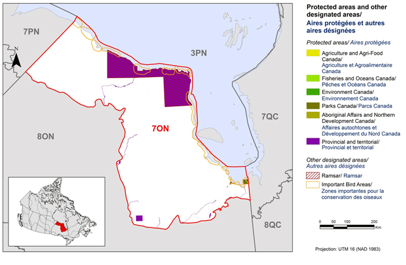
Long description for Figure 3
Map of protected and other designated areas in BCR 7 Ontario Region: Taiga Shield and Hudson Plains. The map’s extent includes northern Manitoba, Ontario and western Quebec. The borders of BCR 3PN, 7PN, 7QC, 8ON and 8QC are delineated. BCR 7 covers the breadth of northern Ontario, from the shores of James and Hudson Bay inland (about the same distance from the shores, so the shape of the BCR sub-region roughly mirrors the coast).
There are two noticeable provincial protected areas, a very large area along the shore of Hudson Bay, and a smaller square area in the very south of the BCR sub-region. There are several Important Bird Areas along the coasts.
The various types of protected areas that exist in the BCR are shown on the map, and are explained in the following bilingual legend (appearing to the right of the map):
Protected areas and other designated areas/Aires protégées et autres aires désignées
- Agriculture and Agri-Food Canada/Agriculture et Agroalimentaire Canada
- Fisheries and Oceans Canada/Pêches et Océans Canada
- Environment and Climate Change Canada/Environnement et Changement climatique Canada
- Parks Canada/Parcs Canada
- Aboriginal Affairs and Northern Development Canada/Affaires autochtones et Développement du Nord Canada
- Provincial/Provincial
Other designated areas/autres aires désignées
- Ramsar/Ramsar
- Important Bird Areas/ Aires d'importance pour les oiseaux
There is also a visual representation of scale for the map in the legend and the projection of the map (i.e. UTM 16 (NAD 1983)).
Ontario’s Far North Act has established a goal for the development of a significant network of new protected areas. Because much of BCR 7 ON remains in a natural state, a unique opportunity exists to define first the matrix of conservation lands needed to maintain biodiversity, ecosystem services, and natural and cultural heritage, and then the areas where development can be sustainably pursued. This “conservation matrix” approach, advocated by the Far North Science Advisory Panel (Far North Science Advisory Panel 2010), holds significant promise for the conservation of migratory birds and their habitats within BCR 7 Ontario. Moreover, this opportunity underscores the need for collaboration between First Nations, provincial and federal agencies, and other stakeholders to achieve the conservation objectives identified in this strategy.
Section 1: Summary of results - All Birds, All Habitats
Element 1: Priority species assessment
These Bird Conservation Strategies identify “priority species” from all regularly occurring bird species in each BCR sub-region. Species that are vulnerable due to population size, distribution, population trend, or threats are included because of their “conservation concern”. Some widely distributed and abundant “stewardship” species are also included. Stewardship species are included because they typify the national or regional avifauna and/or because they have a large proportion of their range and/or continental population in the sub-region; many of these species have some conservation concern, while others may not require specific conservation effort at this time. Species of management interest are also included as priority species when they are at (or above) their desired population objectives but require ongoing management because of their socio-economic importance as game species or because of their impacts on other species or habitats.
In Ontario, significant efforts to define priority species have already been undertaken for shorebirds, waterbirds, waterfowl and landbirds. The results of these bird group-specific planning efforts form the foundation of this integrated bird priority species list for BCR7 Ontario. The priority species list was compiled using information from Ontario Partners in Flight (2010) for landbirds, the North American Waterfowl Management Plan (NAWMP Plan Committee 2004) and the Ontario Eastern Habitat Joint Venture Implementation Plan (2007) for waterfowl, the Ontario Waterbird Conservation Plan Version 1.0 (Zeran et al. 2009) for waterbirds and from the Ontario Shorebird Conservation Plan (Ross et al. 2003) for shorebirds. In addition, species that occur regularly within the BCR and that have been assessed by the Committee on the Status of Endangered Wildlife in Canada (COSEWIC) and/or appear in Schedule 1 of the federal Species at Risk Act (SARA) and/or are listed under the Species at Risk in Ontario list (SARO) in the categories of Endangered, Threatened and Special Concern were added to the priority species list.Footnote 7
The purpose of the prioritization exercise is to focus implementation efforts on the species and issues of greatest significance for Ontario’s avifauna. As with any priority-setting exercise, some important species may be excluded, but the issues of importance to any excluded species are usually captured by addressing the threats identified for species that are included on the priority list. With this in mind, species present in the region only as migrants were included as priority species only when their inclusion introduced new regional conservation issues, such as for the protection of migratory staging sites. Otherwise, we rely on conservation actions arising from threats to other priority species to address more general conservation concerns for migrants. Tables 2-4 summarize the number of priority species in BCR 7 ON by bird group and by the reasons for priority status.
Landbirds exhibit the greatest diversity in BCR 7 Ontario, representing nearly 60% of the species considered (Appendix 1); however, only 24 species qualified for the priority species list (Tables 2, 3). Among the 66 priority species identified, 11 are listed under federal and/or provincial species at risk legislation (Tables 2, 4). Among landbirds, more than 50% of the species on the priority list were included as “stewardship species”; species that may not be declining or face significant threats, but for which the BCR contains a high proportion of the global population (Table 4). In contrast, more than two thirds of the shorebirds present (as breeders or migrants) qualified for priority status, and shorebirds made up a similar fraction of the priority species list despite their lower diversity (Table 3). Waterbirds and waterfowl contributed an additional 21 species to the priority list (Table 3).
Table 2: Priority species in BCR 7 Ontario, population objective and reasons for priority status. All assessments, listings and designations are current to February 2013. Accessible Version of Table 2
| Bird Group | Total Species | Priority Species | % Priority Within Bird Group | Percent of Priority List |
|---|---|---|---|---|
| Landbirds | 118 | 24 | 20% | 36% |
| Shorebirds | 29 | 21 | 72% | 32% |
| Waterbirds | 19 | 9 | 47% | 14% |
| Waterfowl | 30 | 12 | 40% | 18% |
| Total | 196 | 66 | - | 100% |
| Priority Listingc | Landbirds | Shorebirds | Waterbirds | Waterfowl |
|---|---|---|---|---|
| COSEWICd | 5 | 3 | 1 | 0 |
| Federally Listed under SARAe | 5 | 2 | 1 | 0 |
| Provincially Listed under SAROf | 6 | 2 | 2 | 0 |
| National/Continental Concern | 14 | 15 | 6 | 8 |
| National/Continental Stewardshipg | 13 | N/A | N/A | N/A |
| Regional/Sub-regional Concern h | 11 | 21 | 9 | 12 |
| Regional/Sub-regional Stewardship | 15 | N/A | N/A | N/A |
| Management Interesti | 0 | 0 | 0 | 1 |
c A single species can be on the priority list for more than one reason.
d Assessed by COSEWIC (Committee on the Status of Endangered Wildlife in Canada) as: E, Endangered; T, Threatened; SC, Special Concern. Current to February 2013.
e Species listed on Schedule 1 of SARA as E, Endangered; T, Threatened; SC, Special Concern (Species at Risk Public Registry).
f Ontario Species at Risk List.
g Only the landbird group distinguishes stewardship species from other priority species (see Partners in Flight Handbook on Species Assessment PDF; 405 Kb).
h Regional refers to BCR-wide (i.e., all jurisdictional data were used for the entire BCR 7) while sub-regional refers to the Ontario portion of the BCR only (i.e., Ontario BCR data were used).
i Snow Goose is a species of management interest due to its overabundance.
Element 2: Habitats important to priority species
Identifying the broad habitat requirements for each priority species within the BCR allowed species to be grouped by shared habitat-based conservation issues and actions. If many priority species associated with the same habitat face similar conservation issues, then conservation action in that habitat may support populations of several priority species. BCR strategies use a modified version of the standard land-cover classes developed by the United Nations (Food and Agriculture Organization 2000) to categorize habitats, and species were often assigned to more than one habitat class.
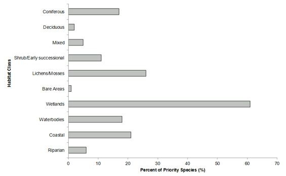
A majority of the priority species (60%) in BCR 7 ON use wetland habitats (Fig. 4), consistent with the importance of this habitat type in the region’s land-cover (77%). Similarly, closed-canopy forest, especially deciduous forest, is used by comparatively few species because it is not a dominant component of the land-cover. Coastal habitats are used by 18% of priority species. The region has nearly 1300 km of marine coastline, and coastal habitats at several locations constitute key staging sites for shorebirds such as the Red Knot and Sanderling, and waterfowl such as Snow Geese and Atlantic Brant. Lichen and moss tundra, used by 25% of priority species, is restricted in Ontario to BCR 7; indeed, Ontario BCR 7’s tundra is the most southerly mainland tundra in the world (Ontario Parks 2010).
Figure 4: Percent of priority species that are associated with each habitat type in BCR 7 Ontario.
Note: The total exceeds 100% because each species may be assigned to more than one habitat.
Long description for Figure 4
A horizontal bar graph indicating the percent of priority species (x axis) that are associated with each habitat type (y axis, coniferous, deciduous, mixed, shrub/early successional, lichens/mosses, bare areas, wetlands, coastal and riparian) in BCR 7 Ontario region. Note: The total exceeds 100% because each species may be assigned to more than one habitat.
| Habitat class | % |
|---|---|
| Coniferous | 17.00 |
| Deciduous | 2.00 |
| Mixed Wood | 5.00 |
| Shrub/Early Successional | 11.00 |
| Lichens/Mosses | 26.00 |
| Bare Areas | 1.00 |
| Wetlands | 61.00 |
| Waterbodies, Snow and Ice | 18.00 |
| Coastal | 21.00 |
| Riparian | 6.00 |
Element 3: Population objectives
Population objectives allow us to measure and evaluate conservation success. The objectives in this strategy are assigned to categories and are based on a quantitative or qualitative assessment of species’ population trends. If the population trend of a species is unknown, the objective is set as “assess and maintain”, and a monitoring objective is given. For any species listed under the Species at Risk Act (SARA) or under provincial/territorial endangered species legislation, Bird Conservation Strategies defer to population objectives in available Recovery Strategies and Management Plans. If recovery documents are not available, objectives are set using the same approach as for other species within that bird group and are considered as interim objectives. Once recovery objectives are available, they will replace interim objectives. The ultimate measure of conservation success will be the extent to which population objectives have been reached within the timeframes set by national and continental pillar plans.
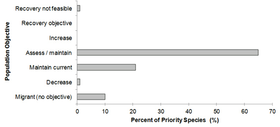
A lack of monitoring information is a pervasive issue in BCR 7 Ontario. Consequently, nearly 65% of priority species, with representatives from all bird groups, were assigned an objective to “assess” population status while “maintaining” current levels in the interim. For 21% of priority species, population levels (typically at a scale larger than BCR 7 Ontario) were deemed to be at or near the objective, and an objective of “maintaining current” population levels was assigned (Fig. 5). A single taxon, the Mid-Continent population of Lesser Snow Goose, was deemed to be overabundant such that an objective of “decreasing” their abundance was appropriate. The general lack of quantitative objectives does not imply that bird populations in Ontario’s portion of the BCR have not changed in abundance, but rather that a lack of rigorous monitoring information for the region precludes assignment of quantitative objectives.
Figure 5: Percent of priority species that are associated with each population objective category in BCR 7 Ontario.
Note: Many species have “Assess/Maintain” because of the paucity of monitoring data from within the BCR. Recovery objectives were not available given the absence of published recovery documents for those priority species, and as such were assigned to the Assess/Maintain category.
Long description for Figure 5
A horizontal bar graph indicating the percent of priority species (x axis) that are associated with each population objective (y axis; recovery not feasible, recovery objective, increase, assess/maintain, maintain current, decrease, migrant (no objective) in BCR 7 Ontario Region.
| Population Objective | % |
|---|---|
| Recovery not feasible | 1 |
| Recovery objectives | 0 |
| Increase | 0 |
| Assess / Maintain | 65 |
| Maintain current | 21 |
| Decrease | 1 |
| Migrant (no population objective) | 10 |
Element 4: Threat assessment for priority species
Bird population trends are driven by factors that affect either their reproduction or survival during any point in their annual cycle. Threats that can reduce survival include, for example, reduced food availability at migratory stopovers or exposure to toxic compounds. Examples of threats that can reduce reproductive success may include high levels of nest predation or reduced quality or quantity of breeding habitat. The threats assessment process identifies threats believed to have a population-level effect on individual priority species. These threats are assigned a relative magnitude (Low, Medium, High, Very High) based on their scope (the proportion of the species’ range within the sub-region that is impacted) and severity (the relative impact on the priority species’ population). This allows us to target conservation actions towards threats with the greatest effects on suites of species or in broad habitat classes. Some well-known conservation issues may not be identified in the literature as significant threats to populations of an individual priority species and therefore may not be captured in the threat assessment. However, they merit attention in conservation strategies because of the large numbers of individual birds affected in many regions of Canada. Usually these issues transcend habitat types and are considered “widespread,” and these issues are addressed in a separate section in the full strategy.
The results of the threat assessment are consistent with the comparatively natural state of BCR 7 Ontario. The lack of information on the status of many priority species and their habitats was perhaps most prevalent in this BCR, and while not considered a threat per se, this lack of information was considered alongside threats in order to establish appropriate monitoring and conservation objectives for priority species in this strategy. A majority of the threats facing priority species within the BCR are of a low magnitude (Fig. 6; Table 5), and the number and magnitude of threats facing bird species in this region are lower than for more southerly BCRs in Ontario. Importantly, a majority of threats were found to have low magnitude effects at present, but may threaten priority species to a greater degree in the future. For example, mining exploration and the limited active production within the BCR currently have low magnitude effects on populations of 17 priority species (25%), but the interest in development of mineral resources is increasing in this region. With resource development comes the strong potential for an expanded network of all-weather and winter roads, rail lines and transmission corridors in BCR 7 Ontario; the threats to priority species from these linear features are low at present (considered a widespread issue; see Section 3 of the full strategy) but will likely increase as development proceeds in the Far North.
At present, the highest magnitude threats identified were related to habitat degradation from overabundant geese and from anthropogenic climate change (Fig. 6). For 41 priority species, a lack of knowledge of population status and limiting factors was a significant impediment to their conservation. These issues are discussed in subsequent sections of the strategy.
Cumulative effects of threats to priority species
For several of the threats related to development identified in this strategy, the long-term impact of several activities is greater than the sum of the impacts of individual activities. There is no standardized method for assessing these “cumulative effects”. The threat ranking and roll-up procedures (Table 5) demonstrate the sum of effects for threats within and among threat categories, and are useful for identifying the most important threats within a habitat class. These procedures also identify whether a large number of low-level threats may be affecting a species. However, it is important to consider that threats might interact in unanticipated ways, or that, in aggregate, threats might exceed some ecological threshold and produce cumulative effects of an unanticipated magnitude. Cumulative effects studies assessing population responses to multiple stressors are an important tool to better understand the long-term consequences of some of the threats described in this strategy.
Figure 6: Percent of identified threats to priority species within BCR 7 ON by threat sub-category.
Each bar represents the percent of the total number of threats identified in each threat sub-category in BCR 7 ON (for example, if 100 threats were identified in total for all priority species in BCR 7, and 10 of those threats were in the category 11.1 Habitat shifting and alteration, the bar on the graph would represent this as 10%). Shading in the bars (VH = very high, H = high, M = medium and L = low) represents the rolled-up magnitude of all threats in each threat sub-category in the BCR.
Note: 5.1 Hunting and collecting terrestrial animals refers to legal hunting and lead poisoning of waterfowl from lead shot, but also includes illegal harvest.

Long description for Figure 6
A horizontal bar graph indicating the percent of identified threats to priority species (x axis) within BCR 7 Ontario Region by threat subcategory (y axis; i.e. Mining and quarrying, problematic native species, etc).
Each bar represents the percent of the total number of threats identified in each sub-threat category in BCR 7 (for example, if 100 threats were identified in total for all priority species in BCR 7, and 10 of those threats were in the category 1.1 Housing and urban areas, the bar on the graph would represent this as 10%). Shading in the bars (VH = very high, H = high, M = medium and L = low) represents the rolled up magnitude of all threats in each threat subcategory in the BCR.
| Threat | % |
|---|---|
| 3.2 Mining and quarrying | 10 |
| 3.3 Renewable energy | 17 |
| 5.1 Hunting and collecting terrestrial animals | 3 |
| 8.2 Problematic native species | 34 |
| 11.1 Habitat shifting and alteration | 36 |
Overall threats were summarized for the sub-region in Table 5. Like the data presented above, 8. Invasive and Other Problematic Species and Genes and 11. Climate Change and Severe Weather are the two main threats. However, the table demonstrates that both of these threats occur in most habitat classes and, in some cases, also varied in rank by habitat class. The overall threat ranking in each habitat is in the top row, while the overall threat ranking for each threat is in the last column.
Table 5: Relative magnitude of identified threats to priority species within BCR 7 ON by threat category and broad habitat class. Accessible Version of Table 5.
Threats to priority species while they are outside of Canada during the non-breeding season were also assessed and are presented in the “Threats Outside Canada” section of the full strategy.
Element 5: Conservation objectives
Conservation objectives were designed to address threats and information gaps that were identified for priority species. They describe the environmental conditions and research and monitoring that are thought to be necessary for progress towards population objectives and to understand underlying conservation issues for priority bird species. As conservation objectives are reached, they will collectively contribute to achieving population objectives. Whenever possible, conservation objectives were developed to benefit multiple species, and/or respond to more than one threat.
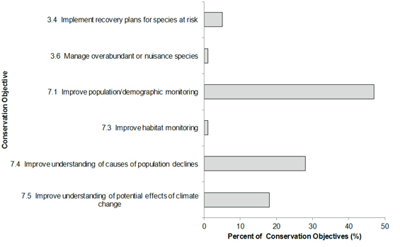
For BCR 7 Ontario, a majority of objectives relate to increasing the understanding of population status and limiting factors (Fig. 7). Objectives in this category attempt to address the significant gaps in population monitoring programs in BCR 7 Ontario, as well as improve understanding of the effects of climate change on bird populations.
Figure 7: Percent of all conservation objectives assigned to each conservation objective category in BCR 7 Ontario.
Long description for Figure 7
A horizontal bar graph indicating the percent of all conservation objectives (x axis) assigned to each conservation objective category (y axis; i.e. improve habitat monitoring, etc) in BCR 7 Ontario Region.
| Objectives | % |
|---|---|
| 3.4 Implement recovery plans for species at risk | 5 |
| 3.6 Manage overabundant or nuisance species | 1 |
| 7.1 Improve population/demographic monitoring | 47 |
| 7.3 Improve habitat monitoring | 1 |
| 7.4 Improve understanding of causes of population declines | 28 |
| 7.5 Improve undestanding of potential effects of climate change | 18 |
Element 6: Recommended actions
Recommended actions indicate on-the-ground activities that will help to achieve the conservation objectives (Fig. 8). Actions are strategic rather than highly detailed and prescriptive. This BCR strategy is directed at multiple species, and the actions proposed here will often benefit a variety of species, including those at risk. However, for detailed recommendations for species at risk, readers should consult recovery documents when available. Similarly, some landbird species included in this strategy are “Stewardship Species” as defined by Partners in Flight (Rich et al. 2004). These are species with stable populations for which no specific conservation issues have been identified, but which depend BCR 7 ON Ontario to such an extent that the region has a high responsibility for their protection. These species may not appear prominently in the threats, objectives and actions described herein, but should benefit from the implementation of actions that target multiple species.
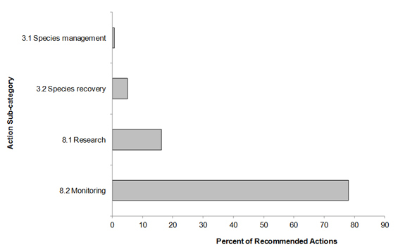
In BCR 7 Ontario, many of the recommended actions relate to knowledge acquisition (Fig. 8). Even basic understanding of distribution and abundance of bird species is lacking for much of this sub-region. Bird surveys in the Hudson Bay Lowlands have been mainly conducted along access routes such as rivers and coastlines. Very few surveys have been conducted in inland habitats (Mainguy and Wedeles 2010). Even in areas where surveys have been carried out, the high cost and logistical difficulties mean that coverage is limited. For example, during the 2001-2005 Ontario Breeding Bird Atlas, search effort in the Hudson Bay Lowlands was mostly within 60-100 km of the coast, and almost all 10 x 10 km squares received less than 20 hours of search effort, as compared to atlas squares in southern Ontario, which often received over 100 hours of search effort (Cadman et al. 2007). An improved understanding of the population status of birds and the anthropogenic activities affecting their status is a prerequisite for effective conservation in BCR 7 Ontario.
Figure 8: Percent of recommended actions assigned to each sub-category in BCR 7 Ontario.
“Research and monitoring” refers to specific species where information is required. For a discussion of broad-scale research and monitoring requirements, see the section on Research and Population Monitoring Needs in the full strategy.
Long description for Figure 8
A horizontal bar graph indicating the percent of recommended action (x axis) assigned to each sub-category of recommended actions (y axis; i.e. Species Management, etc) in BCR 7 Ontario Region.
| Action | % |
|---|---|
| 3.1 Species management | 0.59 |
| 3.2 Species recovery | 5.04 |
| 8.1 Research | 16.32 |
| 8.2 Monitoring | 78.04 |
References
Cadman, M.D., D.A. Sutherland, G.G. Beck, D. Lepage, and A.R. Couturier, eds. 2007. Atlas of the Breeding Birds of Ontario, 2001-2005. Bird Studies Canada, Environment and Climate Change Canada, Ontario Field Ornithologists, Ontario Ministry of Natural Resources, and Ontario Nature, Toronto, xxii + 706 pp.
Colombo S., D. McKenney, K. Lawrence and P. Gray. 2007. Climate change projections for Ontario: practical information for policymakes and planners. Applied Research and Development Branch, Ontario Ministry of Natural Resources, Sault Ste. Marie, Ontario. 38 pp.
Donaldson, G. M., C. Hyslop, R. I. G. Morrison, H. L. Dickson, and I. Davidson (editors). 2000. Canadian Shorebird Conservation Plan. Canadian Wildlife Service, Environment and Climate Change Canada, Ottawa, Ontario. 27pp.
Far North Science Advisory Panel. 2010. Science for a changing Far North: the report of the Far North Science Advisory Panel. A report submitted to the Ontario Ministry of Natural Resources.
Food and Agriculture Organization (FAO). 2000. Land cover classification system. United Nations Food and Agriculture Organization, Rome.
Keddy, P.A. 2000. Wetland ecology: principles and conservation. Cambridge University Press, U.K. 614 pp.Kennedy, J.A., E.A. Krebs, and A.F. Camfield. 2012. A Manual for Completing All-bird Conservation Strategies in Canada, April 2012 version. Canadian Wildlife Service, Environment and Climate Change Canada. Ottawa, ON.
Milko, R., L. Dickson, R. Elliot, and G. Donaldson. 2003. Wings Over Water: Canada’s Waterbird Conservation Plan. Canadian Wildlife Service, Environment and Climate Change Canada, Ottawa, Ontario. 28pp.
Morrison, R.I.G., B.A. Harrington, and L.E. Leddy. 1980. Migration routes and stopover areas of North American Red Knot Calidris canutus wintering in South America. International Wader Study Group Bulletin 28:35-39.
North American Waterfowl Management Plan (NAWMP) Plan Committee. 2004. North American Waterfowl Management Plan 2004. Implementation Framework: Strengthening the Biological Foundation. Canadian Wildlife Service, U.S. Fish and Wildlife Service, pp. 106.
North American Bird Conservation Initiative Canada. 2012. The State of Canada's Birds, 2012. Environment and Climate Change Canada, Ottawa, Canada. 36 pages.
Ontario Eastern Habitat Joint Venture. 2007. Ontario Eastern Habitat Joint Venture Five-year Implementation Plan2006-2010. Environment and Climate Change Canada, Ducks Unlimited Canada, Nature Conservancy of Canada, Ontario Ministry of Agriculture, Food and Rural Affairs, Ontario Ministry of Natural Resources and Wildlife Habitat Canada. Unpublished. 94pp.
Ontario Parks. 2010. Polar Bear Provincial Park: Natural Features. Ontario Parks.
Ontario Partners in Flight. 2010. Ontario Landbird Conservation Plan: Taiga Shield and Hudson Plain, North American Bird Conservation Region 7. Ontario Ministry of Natural Resources, Bird Studies Canada, Environment and Climate Change Canada. Draft Version 2.0. Unpublished Report.
Rich, T.D., C.J. Beardmore, H. Berlanga, P.J. Blancher, M.S.W. Bradstreet, G.S. Butcher, D.W. Demarest, E.H. Dunn, W.C. Hunter, E.E. Inigo-Elias, J.A. Kennedy, A.M. Martell, A.O. Panjabi, D.N., Pashley, K.V. Rosenberg, C.M. Rustay, J.S. Wendt and T.C. Will. 2004. Partners in Flight North American Landbird Conservation Plan. Cornell Lab of Ornithology, Ithaca, NY.
Riley, J.L. 2003. Flora of the Hudson Bay Lowland and its postglacial origins. National Research Council of Canada, Ottawa Ontario. 236 pp.
Ross, K., K. Abraham, R. Clay, B. Collins, J. Iron, R. James, D. McLachlin, R. Weeber, 2003. Ontario Shorebird Conservation Plan. Environment and Climate Change Canada, Downsview, 48 pp.
Species at Risk Public Registry. Accessed 5 August 2013.
Spectranalysis Inc. 2004. Introduction to the Ontario Land-cover Data Base, Second Edition (2000): Outline of Production Methodology and Description of 27 Land-cover Classes. Report to Ontario Ministry of Natural Resources. Unpublished
Turetsky, M.R., J.W. Harden, H.R. Friedli, M.D. Flannigan, N. Payne, J. Crock, and L. F. Radke. 2006. Wildfires threaten mercury stocks in northern soils. Geophys. Res. Lett. 33:L16403 doi:10.1029/2005GL025595.
Mainguy, S. and C. Wedeles. 2010. Assessment of Threats in Ontario Bird Conservation Regions. Unpublished Report Prepared by ArborVitae and North-South Environmental Inc. for Environment and Climate Change Canada. 43 p.
Zeran, R., A. Sandilands, K. Abraham, B. Collins, A. Couturier, D. Kraus, J. McCraken, D. McRae, S. Meyer, R. Morris, C. Pekarik, D. Sutherland, C. Weseloh. 2009. Ontario Waterbird Conservation Plan. Environment and Climate Change Canada-Canadian Wildlife Service (Ontario Region) and Ontario Ministry of Natural Resources. 106 pp. Draft version1.0.
Zhang, S. and C. R. Barnes. 2007. Late Ordovician--Early Silurian conodont biostratigraphy and thermal maturity, Hudson Bay Basin. Bulletin of Canadian Petroleum Geology 55:179-216.