
Bird Conservation Strategy for region 8 in Quebec
- Abridged version -
October 2013

The abridged version of the strategy available here contains a summary of the results, but does not include an analysis of conservation needs by habitat, a discussion of widespread conservation issues, or the identification of research and monitoring needs.
To obtain a copy of the full version of this strategy, please contact migratorybirds_oiseauxmigrateurs@ec.gc.ca.
Table of contents
- Preface
- Acknowledgements
- Bird Conservation Strategy for Bird Conservation Region 8 in Quebec Region - Boreal Softwood Shield
- Executive summary
- Introduction: Bird Conservation Strategies
- Section 1: Summary of results - All Birds, All Habitats
- References
List of figures
- Figure 1. Landcover in BCR 8-QC: Boreal Softwood Shield.
- Figure 2. Map of protected and designated areas in BCR 8-QC: Boreal Softwood Shield.
- Figure 3. Percent of priority species that are associated with each habitat type in BCR 8-QC.
- Figure 4. Percent of priority species that are associated with each population objective category in BCR 8-QC.
- Figure 5. Percent of identified threats to priority species within BCR 8-QC by threat sub-category.
- Figure 6. Percent of all conservation objectives assigned to each conservation objective category in BCR 8-QC.
- Figure 7. Percent of recommended actions assigned to each sub-category in BCR 8-QC.
List of tables
- Table 1. Priority species in BCR 8-QC, population objective, and the reason for priority status.
- Table 2. Summary of priority species, by bird group, in BCR 8-QC.
- Table 3. Number of priority species in BCR 8-QC by reason for priority status.
- Table 4. Relative magnitude of identified threats to priority species within BCR 8-QC by threat category and broad habitat class.
Preface
Environment and Climate Change Canada led the development of all-bird conservation strategies in each of Canada's Bird Conservation Regions (BCRs) by drafting new strategies and integrating new and existing strategies into an all-bird framework. These integrated all-bird conservation strategies will serve as a basis for implementing bird conservation across Canada, and will also guide Canadian support for conservation work in other countries important to Canada's migrant birds. Input to the strategies from Environment and Climate Change Canada’s conservation partners is as essential as their collaboration in implementing their recommendations.
Environment and Climate Change Canada has developed national standards for strategies to ensure consistency of approach across BCRs. Bird Conservation Strategies will provide the context from which specific implementation plans can be developed for each BCR, building on the programs currently in place through Joint Ventures or other partnerships. Landowners including Aboriginal peoples will be consulted prior to implementation.
Conservation objectives and recommended actions from the conservation strategies will be used as the biological basis to develop guidelines and beneficial management practices that support compliance with regulations under the Migratory Birds Convention Act, 1994.
Acknowledgements
Véronique Connolly, Stéphane Légaré, Benoît Audet and François Fournier were the main authors of this document which follows templates developed by Alaine Camfield, Judith Kennedy and Elsie Krebs with the help of the BCR planners in each of the Canadian Wildlife Service regions throughout Canada. However, work of this scope cannot be accomplished without the contribution of other colleagues who provided or validated technical information, commented on earlier draft versions of the strategy, and supported the planning process. We would like to thank the following people: Matthieu Allard, Yves Aubry, Luc Bélanger, Martine Benoît, Daniel Bordage, Pierre Brousseau, Vincent Carignan, Richard Cotter, Marie-France Dalcourt, Emmanuel Dalpé-Charron, Bruno Drolet, Gilles Falardeau, Patricia Houle, Benoît Jobin, Sandra Labrecque, Claudie Latendresse, Josée Lefebvre, Christine Lepage, Jean-François Rail and François Shaffer.
Bird Conservation Strategy for Bird Conservation Region 8 in Quebec Region - Boreal Softwood Shield
Long description for map of BCR 8
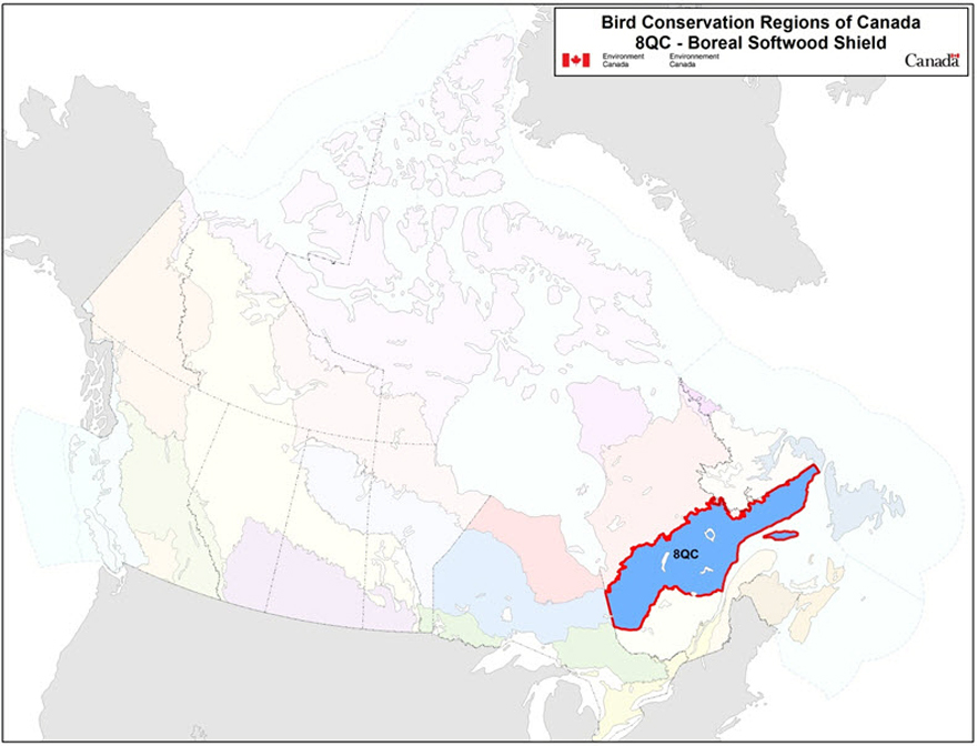
Map of the Bird Conservation Regions (BCRs) of Canada with BCR 8 QC highlighted. The extent of the map includes Canada, with Alaska, Greenland and the northern portion of the U.S. also appearing. The map is divided by BCR (12 Canadian BCRs in total), with various colours, and their exact locations and sizes are indistinguishable, aside from BCR 8 QC. The highlighted BCR 8 QC occupies a diagonal portion of central Quebec from Abitibi to the Gulf of St. Lawrence, and includes Anticosti Island. Legend: Bird Conservation Regions of Canada. 8 QC - Boreal Softwood Shield; Environment and Climate Change Canada logo, and Government of Canada logo.
Executive summary
The Quebec portion of the Boreal Softwood Shield Bird Conservation Region (BCR 8-QC) covers Quebec from east to west between roughly the 48th and 52nd parallels, with a surface area of 543 003 km2. BCR 8-QC has primarily hilly terrain and, to a large extent, is covered with coniferous forest. The aquatic portion of the region includes the entire northern half of the Lower Estuary and Gulf of St. Lawrence, as well as a large number of rivers and lakes. There are limited farming and urban areas, and the main human activities include forestry, mining and hydroelectric power. The birds that nest in BCR 8-QC are primarily forest species. The numerous coastal islands provide nesting sites for seabirds and the coastal habitats are inhabited by several shorebird species during migration.
After an assessment of 246 bird species found in BCR 8-QC, 97 species were identified as priorities in this BCR. The priority list includes species from four bird groups: landbirds (56%), waterbirds (19%), waterfowl (13%) and shorebirds (12%). These priority species include 21 species considered at risk either provincially or federally. Priority species use 10 habitat types in BCR 8-QC. The habitats that attract the most birds are the wetlands (31% of priority species), coastal areas (30%), coniferous forests (30%), mixed wood forests (29%), waterbodies (16%), and riparian areas (15%).
Each priority species was assigned a population objective based on its population trend. Assessing/maintaining populations at current levels was the objective most often selected for priority species in BCR 8-QC (44% of priority species), while maintaining the populations was the objective assigned to 19% of the species. Better population trend data are required for all species that have been assigned one of these two objectives. A recovery objective was assigned to 16% of the species (all are species at risk), and population increase objectives were also assigned to 21% of the priority species. Overall, 37% of priority species identified in BCR 8-QC have a population objective related to population increase, reflecting the magnitude of the threats to bird populations in this BCR.
A threat assessment identified a number of conservation issues facing priority species in the various habitats of BCR 8-QC. Major threats include habitat loss and degradation caused by forestry and agriculture, as well as climate change and severe weather. The lack of biological or demographic data on priority species and the ongoing need for the finalization of recovery strategies and management plans for federally listed species at risk were also considered to be significant conservation issues, as a total of 95% of the priority species are affected. The habitats most severely affected by the threats in BCR 8-QC include wetlands, coastal areas, cultivated and managed areas, and urban habitat.
Conservation objectives have been established to counter threats and provide the missing information on priority species. Conservation objectives in BCR 8-QC aim mainly to improve bird population monitoring in order to gather the missing ecological and demographic information on most of the priority species in this BCR. Another important conservation objective is to provide adequate habitat for priority species, by ensuring, for example, that resource and land use policies and practices maintain or improve bird habitat.
Conservation actions have been recommended for priority species in BCR 8-QC in order to achieve established conservation objectives. The recommended actions largely relate to population monitoring and include on-the-ground activities such as increasing the coverage of the Breeding Bird Survey (BBS), conducting species specific surveys, expanding the current migration monitoring program, and updating existing waterfowl banding and survey programs. Another large proportion of the recommended actions involves the development and adoption of beneficial management practices by the renewable power, forestry, mining, and agriculture sectors.
Migratory birds found in BCR 8-QC also face threats that are difficult to analyze with the standardized methodology used in this strategy. These threats include widespread issues that may sometimes not apply to a particular habitat (e.g., collisions with human-made structures, air pollution and climate change), research needs and population monitoring, as well as threats to migratory birds when they are outside Canada. An overview of these issues, the affected species and the recommended conservation actions is also presented.
Introduction: Bird Conservation Strategies
Context
This document is one of a suite of Bird Conservation Region Strategies (BCR strategies) that have been drafted by Environment and Climate Change Canada for all regions of Canada. These strategies respond to Environment and Climate Change Canada's need for integrated and clearly articulated bird conservation priorities to support the implementation of Canada's migratory birds program, both domestically and internationally. This suite of strategies builds on existing conservation plans for the four “bird groups” (waterfowlFootnote 1, waterbirdsFootnote 2, shorebirdsFootnote 3 and landbirdsFootnote 4) in most regions of Canada, as well as on national and continental plans, and includes birds under provincial/territorial jurisdiction. These new strategies also establish standard conservation planning methods across Canada and fill gaps, as previous regional plans do not cover all areas of Canada or all bird groups.
These strategies present a compendium of required actions based on the general philosophy of achieving scientifically based desired population levels as promoted by the four pillar initiatives of bird conservation. Desired population levels are not necessarily the same as minimum viable or sustainable populations, but represent the state of the habitat/landscape at a time prior to recent dramatic population declines in many species from threats known and unknown. The threats identified in these strategies were compiled using currently available scientific information and expert opinion. The corresponding conservation objectives and actions will contribute to stabilizing populations at desired levels.
The BCR strategies are not highly prescriptive. In most cases, practitioners will need to consult additional information sources at local scales to provide sufficient detail to implement the recommendations of the strategies. Tools such as beneficial management practices will also be helpful in guiding implementation. Partners interested in participating in the implementation of these strategies, such as those involved in the habitat Joint Ventures established under the North American Waterfowl Management Plan (NAWMP), are familiar with the type of detailed implementation planning required to coordinate and undertake on-the-ground activities.
Strategy structure
Section 1 of this strategy, published here, presents general information about the BCR and the subregion, with an overview of the six elementsFootnote 5 that provide a summary of the state of bird conservation at the subregional level. Section 2, included in the full version of this strategy, provides more detail on the threats, objectives and actions for priority species grouped by each of the broad habitat types in the subregion. Section 3, also included in the full version, presents additional widespread conservation issues that are not specific to a particular habitat or were not captured by the threat assessment for individual species, as well as research and monitoring needs, and threats to migratory birds while they are outside of Canada. The approach and methodology are summarized in the appendices of the full strategy, but details are available in a separate document (Kennedy et al. 2012). A national database houses all the underlying information summarized in this strategy and is available from Environment and Climate Change Canada.
Characteristics of Bird Conservation Region 8
The Boreal Softwood Shield Bird Conservation Region (BCR 8) is a vast region extending from the Alberta-Saskatchewan border to Newfoundland. The Quebec portion of BCR 8-QC covers Quebec from east to west between roughly the 48th and 52nd parallels, with a surface area of 543 003 km2 (Figure 1). It includes northern Abitibi, the southern portion of northern Quebec, and most of Saguenay-Lac-St-Jean and the North Shore. It also includes the northern half of the Lower Estuary and Gulf of St. Lawrence, Anticosti Island, and all the coastal islands in this area.
Figure 1. Landcover in BCR 8-QC: Boreal Softwood Shield.

Long description for Figure 1
Map of the landcover in BCR 8 QC. The map’s extent includes most of Quebec, with some of Ontario and the Maritimes. The borders of adjoining BCRs are delineated. BCR 8 QC occupies a diagonal portion of central Quebec from Abitibi to the Gulf of St. Lawrence, and includes Anticosti Island.
The various habitat types that exist in the BCR are shown on the map, and are explained in the following bilingual legend (appearing to the right of the map):
- Coniferous/conifères
- Deciduous/feuillus
- Mixedwood/forêt mixte
- Shrubs and early successional/arbustes et régénération
- Herbaceous/herbacées
- Cultivated and managed areas/zone cultivées et aménagées
- Lichens and mosses/lichens et mousses
- Wetlands/terres humides
- Alpine/alpin
- Snow and ice/neige et glace
- Bare areas/denude
- Urban/urbain
- Water bodies /plans d’eau
- Riparian/riverain
- Coastal/côtier
The remaining text in the legend provides the data sources for the map (Land Cover Map of Canada 2005 (CCRS, 2008), the projection of the map (UTM 9 (NAD 1983)) and there is a visual representation of the scale of the map. For BCR 8 QC, the most common habitat types are coniferous forests, waterbodies, mixed forest and wetlands.
Physical environment
Topography
The topography of BCR 8-QC consists mostly of large hills with elevations varying between 300 and 600 m(Ecological Stratification Work Group 1996). While the topography of the BCR's western end (Abitibi Plains) and Anticosti Island is rather gentle, the remainder of the region is more hilly. The highest summits include the Otish Mountains (with Mount Yapeitso at an elevation of 1128 m), the Groulx Mountains (including Mount Veyrier at an elevation of 1104 m), the Valin Mountains (rising to 980 m), and Mount Babel (952 m; Commission de toponymie Québec 2012).
Hydrography and hydrology
The drainage system of BCR 8-QC includes the entire northern half of the Lower Estuary and the Gulf of St. Lawrence. It also includes large rivers, such as the Saguenay, Péribonka, Mégiscane, Manicouagan, Moisie, Nottaway, Aux Outardes and Romaine rivers. The BCR includes a large number of small lakes and several large lakes: for example, lakes Mistassini (2113 km2), Saint-Jean (1041 km2), Abitibi (878 km2), Manouane (461 km2), Plétipi (339 km2) and Waswanipi (205 km2; Gouvernement du Quebec 2002). The region is also home to large reservoirs created for hydroelectric purposes: for example, the Manicouagan (2072 km2), Pipmuacan (779 km2) and Outardes 4 (730 km2) reservoirs.
Climate
Summers are cool in most of BCR 8-QC, with the exception of the Saguenay-Lac St-Jean region where they are rather hot and humid. Summers are also rainy on the coast of the Gulf of St. Lawrence and Anticosti Island. The average summer temperature of the BCR varies between 11.5° and 12.5°C. Winters are cold throughout the subregion. The average winter temperature varies between -13.5° and -12.5°C in the western portion of the subregion and -9°C in the east. The average annual temperature is 0°C in the west and ranges between 1° and 1.5°C in the east. The average annual rainfall varies between 650 and 900 mm in the west and 800 and 1100 mm in the east. It exceeds 1000 mm on the coast of the Gulf of St. Lawrence where the shore is continually windy (Ecological Stratification Working Group 1996).
Land cover and land use
Most of the land in BCR 8-QC is covered by forest, which is mainly coniferous (Figure 1). Wetlands cover nearly 6% of the BCR's area and are especially common in the western part of the subregion. Cultivated and managed areas account for only 0.4% of the land area and are limited to Abitibi and Saguenay-Lac-Saint-Jean regions. Urban areas are also limited, accounting for only 0.1% of the subregion area. Almost all of the land in the BCR is publicly owned (Drolet et al. 2010). The main human activities in this BCR are forestry, mining, hydroelectric power, hunting, trapping, and recreation and tourism activities (Ecological Stratification Working Group 1996).
BCR 8-QC is also part of the zone covered by the northern development initiative of the government of Quebec, the objective of which is to sustainably develop the economic potential of northern Quebec. The economic sectors included in this initiative in BCR 8-QC are mining, energy, forestry, transportation and telecommunications (Gouvernement du Québec 2013). The government of Quebec is committed to allocating 50% of the northern development area for environmental protection, to preserve biodiversity and the enhancement of natural heritage. The implementation of this initiative could possibly change the face of BCR 8-QC.
Biological environment
Vegetation
BCR 8-QC is represented by three vegetation subzones: mixed wood forest in the Saguenay and Lac Saint-Jean lowlands, continuous boreal forest in most of the BCR, and taiga in a thin strip at the northern boundary of the subregion (Ministère des Ressources naturelles 2013).
The mixed wood forest consists of the balsam fir-yellow birch domain, which is a transition area between the deciduous and boreal forest. This type of forest is characterized by mixed stands of yellow birch and conifers such as balsam fir, white spruce, and cedar. The main factors of forest dynamics in this vegetation subzone are outbreaks of spruce budworm and fires.
The continuous boreal forest consists of two types of vegetation in BCR 8-QC: balsam fir-white birch stands in certain parts of the south and spruce-moss stands in most of the subregion. The balsam fir-white birch domain is characterized by fir and white spruce mixed with white birch mesic sites, while less favourable sites include black spruce, jack pine and larch, accompanied by white birch or trembling aspen. The main factors of forest dynamics for this type of vegetation are outbreaks of spruce budworm and fires. The spruce-moss forest is clearly dominated by black spruce, but there are also balsam fir and some deciduous trees such as white birch and trembling aspen. This type of vegetation is also characterized by undergrowth covered with feather mosses and ericaceous shrubs, and a limited number of herbaceous species. The fire cycle is the main element of forest dynamics in the spruce-moss domain.
Lastly, the taiga covers a small portion of northern BCR 8-QC and consists of spruce-lichen forests. Tree density is lower here than in the spruce-moss forest, and the moss layer is dominated by lichens. Aside from black spruce, balsam fir and jack pine are also found here at the northern edge of their range. Fire is the main driver of forest dynamics for this type of vegetation.
Wildlife
Mammals representative of BCR 8-QC include the Woodland caribou (a vulnerable species in Quebec and threatened in Canada), Black Bear, beaver, fisher, Canada lynx, American marten and wolf (Li and Ducruc 1999). The marine portion of BCR 8-QC includes marine mammals considered at risk in Canada (Species at Risk Public Registry 2012): the right whale and blue whale, both endangered species; the beluga, a species that is “threatened” in both Quebec and Canada (Ministère du Développement durable, de l’Environnement, de la Faune et des Parcs 2013); and the Fin Whale, a species of “special concern.”
The herpetofauna of BCR 8-QC includes characteristic species such as the American toad, wood frog, northern leopard frog, spring peeper, two-lined salamander and Eastern garter snake. The leatherback turtle, a species at risk in both Quebec and Canada (Ministère du Développement durable, de l’Environnement, de la Faune et des Parcs 2013; Species at Risk Public Registry 2012), is present in the marine portion of the BCR.
BCR 8-QC is home to a diverse fish fauna. Representative fish species include the walleye, northern pike, lake trout, brook trout, Atlantic salmon, Atlantic herring and capelin (Li and Ducruc 1999; Bourdages and Ouellette 2011). The American shad, a “Vulnerable” species in Quebec, and Atlantic sturgeon, a species “Likely to be designated threatened or vulnerable” in Quebec, are also present in BCR 8-QC.
The avifauna of BCR 8-QC consists mostly of boreal forest species. These species include the Spruce Grouse, Black-backed Woodpecker, American Three-toed Woodpecker, Yellow-bellied Flycatcher, Bay-breasted Warbler, Tennessee Warbler, Cape May Warbler, Mourning Warbler and White-winged Crossbill. Species using the numerous lakes and wetlands of the BCR during nesting season include the Red-throated Loon, American Black Duck, Common Teal, Ring-necked Duck, Common Goldeneye and Common Merganser. Some aquatic bird species reach the limit of their range in BCR 8-QC (for example, the Pied-billed Grebe, Green Heron, Virginia Rail, Common Moorhen, and American Coot; Chapdelaine and Rail 2004). The numerous coastal islands of the northern coast and the steep cliffs on the northern side of Anticosti Island provide nesting sites for several seabird species. These species include the Double-crested Cormorant, Great Cormorant, Black-legged Kittiwake, Black Guillemot, Razorbill, Common Murre and Atlantic Puffin. BCR 8-QC is home to half the nesting shorebird species in Quebec (Aubry and Cotter 2007). Representative species include the Greater Yellowlegs, Solitary Sandpiper, Spotted Sandpiper and Wilson's Snipe. In addition, several shorebird species frequent the coastal habitats of the BCR during migration: for example, the Dunlin, Sanderling, Semipalmated Sandpiper, White-rumped Sandpiper, Black-bellied Plover and Semipalmated Plover. Lastly, the Estuary and Gulf of St. Lawrence are a wintering area for several duck species, such as the Long-tailed Duck, Common Eider, Barrow's Goldeneye and Red-breasted Merganser.
Human environment
Approximately 514 000 people live in BCR 8-QC, which represents 6.5% of the Quebec population (adapted from Statistics Canada 2012). The main population centres are Saguenay (144 746 inhabitants), Rouyn-Noranda (41 012), Val-d'Or (31 862), Alma (30 904), Sept-Îles (25 686) and Baie-Comeau (22 113). BCR 8-QC includes 14 Aboriginal communities totalling nearly 19 000 inhabitants (Aboriginal Affairs and Northern Development Canada 2010), nearly half of whom live in the North Shore region. The two largest Aboriginal communities are Mistissini (Cree Nation) and Takuaikan Uashat mak Mani-Utenam (Innu Nation), each of which has more than 3 000 inhabitants.
Protected and designated areas
Protected areas and other designated areas cover approximately 8% of the land in BCR 8-QC (Figure 2). Four Quebec national parks (operated by Quebec's Ministère du Développement durable, de l'Environnement, de la Faune et des Parcs) and a Canadian national park reserve (operated by Parks Canada) are entirely located within the BCR, covering a total area of 1237 km2. These parks are the Mingan Archipelago National Park Reserve of Canada and the national parks of Aiguebelle, Pointe-Taillon, Monts-Valin and Anticosti. BCR 8-QC also includes nearly 75% of Fjord-du-Saguenay national park (of Quebec) and 70% of the Saguenay-St. Lawrence Marine Park (joint responsibility of Parks Canada and Quebec's Ministère du Développement durable, de l'Environnement, de la Faune et des Parcs).
Protected areas in BCR 8-QC also include 9 migratory bird sanctuaries (under Environment and Climate Change Canada's mandate) covering an area of 326 km2 and 43 exceptional forest ecosystems (old-growth forests, rare forests and shelter forests; responsibility of Quebec’s Ministère des Ressources naturelles) totalling 141 km2. There are also 236 waterfowl staging areas that together cover an area of 1667 km2, and 6 planned aquatic reserves (responsibility of Quebec's Ministère du Développement durable, de l'Environnement, de la Faune et des Parcs) representing an area of 4863 km2.
Lastly, BCR 8-QC also includes areas designated as important for birds, but that do not have legal protection status. There are 25 Important Bird Areas (IBA) totalling 1598 km2 (most of these overlap some of the protected areas mentioned above).
Figure 2. Map of protected and designated areas in BCR8-QC: Boreal Softwood Shield.
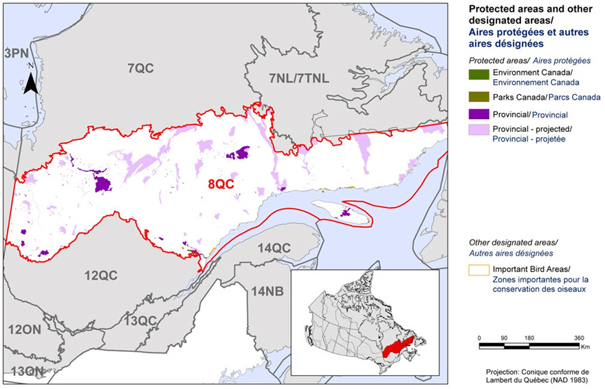
Long description for Figure 2
Map of protected and other designated areas in BCR 8 QC. The map’s extent includes most of Quebec, with some of Ontario and the Maritimes. The borders of adjoining BCRs are delineated. BCR 8 QC occupies a diagonal portion of central Quebec from Abitibi to the Gulf of St. Lawrence, and includes Anticosti Island.
Protected areas/Aires protégées
- Environment and Climate Change Canada/Environnement et Changement climatique Canada
- Parks Canada/Parcs Canada
- Provincial/Provincial
- Provincial-projected/Provincial-projetée
Other designated areas/autres aires désignées
- Important Bird Areas/Aires d'importance pour les oiseaux
The most common type of protected area shown is provincial and projected provincial, with several small Important Bird Areas. There is also a visual representation of scale for the map in the legend and the projection of the map (i.e. UTM 9 (NAD 1983)).
Section 1: Summary of results - All Birds, All Habitats
Element 1: Priority species assessment
These Bird Conservation Strategies identify “priority species” from all regularly occurring bird species in each BCR subregion. Species that are vulnerable due to population size, distribution, population trend, abundance and threats are included because of their “conservation concern”. Some widely distributed and abundant “stewardship” species are also included. Stewardship species are included because they typify the national or regional avifauna and/or because they have a large proportion of their range and/or continental population in the subregion; many of these species have some conservation concern, while others may not require specific conservation effort at this time. Species of management concern are also included as priority species when they are at (or above) their desired population objectives but require ongoing management because of their socio-economic importance as game species or because of their impacts on other species or habitats.
The purpose of the prioritization exercise is to focus implementation efforts on the issues of greatest significance for Canadian avifauna. Table 1 provides a full list of all priority species and their reason for inclusion. Tables 2 and Table 3 summarize the number of priority species in BCR 8-QC by bird group and by the reason for priority status.
The standard method for selecting priority species was used to identify 94 priority species, sub-species or populations (hereinafter referred to as “species”) on a preliminary basis, among the 246 species found in BCR 8-QC. Regional experts reviewed the preliminary list and 17 pre-selected species were excluded and 20 others were added, leading to a final list of 97 priority species (Table 1).
The 97 priority species identified are not evenly distributed among the 4 bird groups. The 54 landbird species are the most represented group with 56% of all priority species in BCR 8-QC (Table 2). This is a representative picture of the importance of landbirds in the subregion, as they account for 58% of all species present. Thirty-five percent (12 species) and 34% (13 species) of shorebird species and waterfowl species, respectively, found in BCR 8-QC have been identified as priority species. Lastly, 60% (18 species) of aquatic bird species found in BCR 8-QC have been identified as priority species, which shows the precarious status of this group of birds in the BCR.
More than half of the priority species (58%) have been identified for conservation reasons (Table 1, shaded cells). They include 21 species at risk, which are either listed provincially under Quebec’s Loi sur les espèces menacées ou vulnérables [Act respecting threatened or vulnerable species] or listed nationally under the Species at Risk Act (SARA), or have been assessed by the Committee on the Status of Endangered Wildlife in Canada (COSEWIC). Thirteen species are considered at risk provincially and nationally, 5 species are considered at risk only provincially (Golden Eagle, Leach's Storm-Petrel, Bald Eagle, Caspian Tern and Sedge Wren), while 3 species are considered at risk only under national legislation. The latter species include the Bobolink, Barn Swallow and Eastern Meadowlark, which were assessed by COSEWICbut are not currently listed on Schedule 1 of SARA. Apart from the conservation species, 41 others have been identified as priority species for stewardship reasons (Table 1; unshaded cells).
Table 1. Priority species in BCR 8-QC, population objective, and the reason for priority status.
Accessible version of Table 1
| Bird Group | Total Species | Total Priority Species | Percent Listed as Priority | Percent of Priority List |
|---|---|---|---|---|
| Landbird | 144 | 54 | 38% | 56% |
| Shorebird | 34 | 12 | 35% | 12% |
| Waterbird | 30 | 18 | 60% | 19% |
| Waterfowl | 38 | 13 | 34% | 13% |
| Total | 246 | 97 | 39% | 100% |
| Reason for Priority Listinga | Landbirds | Shorebirds | Waterbirds | Waterfowl |
|---|---|---|---|---|
| COSEWICb | 12 | 1 | 1 | 2 |
| Federal SARA listedc | 9 | 1 | 1 | 2 |
| Provincially listedd | 12 | 1 | 3 | 2 |
| National/Continental Concernd | 22 | - | - | - |
| Regional Concerne | 5 | - | - | - |
| Continental Stewardshipf | 23 | - | - | - |
| Regional Stewardshipe | 24 | - | - | - |
| Conservation categoryf | - | 10 | - | - |
| Priority levelg | - | - | 10 | - |
| NAWMPh | - | - | - | 9 |
| Expert reviewi | 7 | 2 | 7 | 4 |
a A single species can be on the priority list for more than one reason. Note that not all reasons for inclusion apply to every bird group (indicated by “-”).
b COSEWIC indicates species assessed by the Committee on the Status of Endangered Wildlife in Canada as Endangered, Threatened, or Special Concern.
c Species listed on Schedule 1 of the SARA as Endangered, Threatened, or Special Concern.
d Provincially Listed indicates species listed by the Loi sur les espèces menacées ou vulnérables (Quebec) as Threatened, Vulnerable or Likely to be designated threatened or vulnerable.
e See Table 1.
f Conservation category indicates a species ranked in Canada's Shorebird Conservation Plan(Donaldson et al. 2000) as having a 5, 4a, 4b or 3a conservation category in the United States of America and Canada.
g Priority level indicates a species ranked in Canada's Waterbird Conservation Plan (Milko et al. 2003) as belonging to Tier 1 or Tier 2.
h NAWMP indicates species ranked in the North American Waterfowl Management Plan (Plan Committee 2004) as having Highest, High or Moderately High breeding or non-breeding conservation and/or monitoring needs in the BCR.
i Species that did not meet the standard criteria but were added by the experts.
Element 2: Habitats important to priority species
Identifying the broad habitat requirements for each priority species within the BCR allowed species to be grouped by shared habitat-based conservation issues and actions. If many priority species associated with the same habitat face similar conservation issues, then conservation action in that habitat may support populations of several priority species. BCR strategies use a modified version of the standard land cover classes developed by the United Nations (Food and Agriculture Organization 2000) to categorize habitats and species were often assigned to more than one habitat class.
Priority species use 10 habitat types in BCR 8-QC (Figure 3). Although they represent only 6% of the BCR land area, wetlands are the type of habitat most used by priority species (30 species or 31% of all priority species in the BCR). This habitat class is used by all four bird groups, with landbirds dominating (14 species).
The second most-frequently used habitat classes in BCR 8-QC are coastal areas and coniferous forests (each used by 29 species, or 30% of priority species). The coastal areas are used by all 4 bird groups (waterbirds dominate with 12 species) while the coniferous forest is only frequented by landbirds.
Mixed wood forests (used by 29% of priority species), waterbodies (16%) and riparian areas (15%) are among the habitats most used by priority species. Mixed wood forests are only used by landbirds, whereas the riparian areas and waterbodies are used by species from the four bird groups.
See Section 2 of the full strategy for additional details on priority species, threats, and conservation actions for each habitat class in BCR 8-QC.
Figure 3. Percent of priority species that are associated with each habitat type in BCR 8-QC.
Note: The total exceeds 100% because each species may be assigned to more than one habitat.
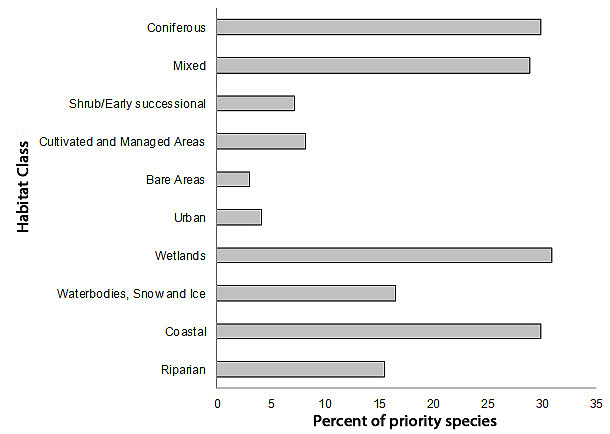
Long description for Figure 3
A horizontal bar graph indicating the percent of priority species (x axis) that are associated with each habitat type (y axis, coniferous, mixed, shrub/early successional, cultivated and managed areas, bare areas, urban, wetlands, waterbodies, coastal, and riparian) in BCR 8 QC region.
| Habitat | % |
|---|---|
| Coniferous | 30 |
| Mixed | 29 |
| Shrub/Early successional | 7 |
| Cultivated and Managed Areas | 8 |
| Bare Areas | 3 |
| Urban | 4 |
| Wetlands | 31 |
| Waterbodies, Snow and Ice | 16 |
| Coastal | 30 |
| Riparian | 15 |
Element 3: Population objectives
Population objectives allow us to measure and evaluate conservation success. The objectives in this strategy are assigned to categories and are based on a quantitative or qualitative assessment of species' population trends. If the population trend of a species is unknown, the objective is set as “assess and maintain” and a monitoring objective is given. For any species listed under SARA or under provincial/territorial endangered species legislation, Bird Conservation Strategies defer to population objectives in available Recovery Strategies and Management Plans. The ultimate measure of conservation success will be the extent to which population objectives have been reached over the next 40 years. Population objectives do not currently factor in feasibility of achievement, but are held as a standard against which to measure progress.
“Assess/Maintain” was the objective assigned to the greatest number of priority species in BCR 8-QC (44% of priority species; Figure 4). For all species with this objective, there is a lack of the biological or demographic information required for adaptive population management. This is also the case for species that have been assigned the objective of maintaining populations at their current level (19% of priority species).
A recovery objective was assigned to 16% of priority species in BCR 8-QC, reflecting the proportion of priority species in BCR 8-QC that are listed in Schedule 1 of SARA or that have a status of “threatened” or “vulnerable” according to Quebec's Loi sur les espècesmenacées ou vulnérables. In addition to these recovery objectives, which all seek to increase populations of species at risk, population increase objectives were also assigned to 21% of priority species under the categories “Increase,” “Increase 50%,” and “Increase 100%.” Overall, 37% of priority species identified in BCR 8-QC were assigned a population increase objective. This reflects the magnitude of the threats affecting bird populations in this BCR.
Figure 4. Percent of priority species that are associated with each population objective category in BCR 8-QC.

Long description for Figure 4
| Population Objective | % |
|---|---|
| Recovery objective | 16 |
| Increase 100% | 4 |
| Increase 50% | 11 |
| Increase | 5 |
| Assess / Maintain | 44 |
| Maintain current | 19 |
Element 4: Threat assessment for priority species
The threats assessment process identifies threats believed to have a population-level effect on individual priority species. These threats are assigned a relative magnitude (Low, Medium, High, Very High), based on their scope (the proportion of the species' range within the subregion that is impacted) and severity (the relative impact on the priority species' population). This allows us to target conservation actions towards threats with the greatest effects on suites of species or in broad habitat classes. Some well-known conservation issues (such as predation by domestic cats or climate change) may not be identified in the literature as significant threats to populations of an individual priority species and therefore may not be captured in the threat assessment. However, they merit attention in conservation strategies because of the large numbers of individual birds affected in many regions of Canada. We have incorporated them in a separate section on Widespread Issues, but, unlike other threats, they are not ranked.
Bird populations found in BCR 8-QC face many threats from different sources. No less than 453 threats classified into 11 categories and 24 sub-categories have been identified and are summarized in Figure 5. Threat category “12. Other direct threats,” represented by sub-category “12.1 Information lacking,” is the category most frequently associated with priority species in BCR 8-QC and includes 41% of all identified low-magnitude threats (Table 4). This category includes the lack of biological or demographic information required for adaptive population management and the ongoing need for the finalization of recovery strategies and management plans for federally listed species at risk. Only 5 of the 21 species at risk in BCR 8-QC had a finalized recovery or management plan when this strategy was written. The need for more information was an issue raised for 92 of the 97 priority species (95%) in BCR 8-QC.
The category “5. Biological resource use” ranks second for the percentage of threats affecting priority species in BCR 8-QC, with 15% of all threats. This high-magnitude category is primarily represented by sub-categories “5.1 Hunting and collecting terrestrial animals” and “5.3 Logging and wood harvesting,” which account for 6% and 8% of the identified threats, respectively. These high-magnitude sub-categories consist of threats such as a lack of knowledge on the extent of subsistence hunting and its impact on bird populations, and habitat loss and degradation (for example, disappearance of mature forests, logging in forested wetlands, and the scarcity of large-diameter trees, dead tree stands, and snags for cavity-nesting birds).
The category “3. Energy production and mining” includes 10% of all identified threats and has a “Medium” overall magnitude. This category is represented primarily by the medium-magnitude sub-categories “3.2 Mining and quarrying” and “3.3 Renewable energy,” which include threats of habitat loss and degradation from mining projects and permanent or seasonal flooding of natural habitats.
Category “2. Agriculture and aquaculture” has a “High” overall magnitude and is primarily represented by the sub-category “2.1 Annual and perennial non-timber crops,” which accounts for nearly 8% of all identified threats. This sub-category includes elements such as the drainage and filling of wetlands for farming purposes, habitat loss and degradation due to the transition from perennial to annual crops, intensification of agriculture, and incidental bird mortality at harvest time.
Category “9. Pollution” includes 7% of identified threats and has a “Medium” overall magnitude. This category is represented primarily by sub-categories “9.2 Industrial and military effluents” and “9.3 Agricultural and forestry effluents.” The first sub-category is associated with oil spills while the second is associated with overuse of pesticides, which can cause bird poisoning, eggshell thinning, and a reduction in prey insect and fish populations.
Category “11. Climate change and severe weather” includes only 4% of identified threats, but its overall magnitude is “High.” This category includes two high-magnitude sub-categories in BCR 8-QC: “11.1 Habitat shifting and alteration” and “11.5 Other impacts.” The only threat in sub-category 11.1 is changes in the number, size and location of wetlands due to global climate change, while sub-category 11.5 involves the higher frequency of adverse weather events that may affect migration, reproductive success, nesting phenology and prey availability.
Each of the “1. Residential and commercial development”, “4. Transportation and service corridors,” “6. Human intrusions and disturbance,” “7. Natural system modifications,” and “8. Invasive and other problematic species and genes” threat categories includes less than 5% of all identified threats and have a “Low” or “Medium” overall magnitude.
The overall magnitude of threats is “High” in 4 of the 10 habitat classes in BCR 8-QC: cultivated and managed areas, urban areas, wetlands, and coastal areas. Of these habitats, the urban habitat is the only one to experience “High” magnitude threats due to residential and commercial development (category 1), while the cultivated and managed areas are the only habitat class affected by “Very high” magnitude threats due to agriculture and aquaculture (category 2). Category “5. Biological resource use” has a “High” magnitude impact on coniferous habitats, wetlands and coastal areas. Lastly, cultivated and managed areas, urban habitat, wetlands, and riparian areas are affected by “High” magnitude threats due to climate change and severe weather (category 11), while only coastal areas face “High” magnitude threats due to pollution (category 9).
Section 2 of the full strategy provides additional details on the threats associated with the various habitat classes. Threats to priority species while they are outside Canada during the non-breeding season were also assessed and are presented in the Threats Outside Canada section of the full strategy.
Figure 5. Percent of identified threats to priority species within BCR 8-QC by threat sub-category.
Each bar represents the percent of the total number of threats identified in each threat sub-category in BCR 8 (for example, if 100 threats were identified in total for all priority species in BCR 8, and 10 of those threats were in the category 1.1 Housing and urban areas, the bar on the graph would represent this as 10%). Shading in the bars (VH = very high, H = high, M = medium and L = low) represents the overall magnitude of all threats in each threat sub-category in the BCR.
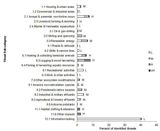
Long description for Figure 5
| Threat | %L | %M | %H | %VH |
|---|---|---|---|---|
| 1.1 Housing and urban areas | 2 | 0 | 0 | 0 |
| 1.2 Commercial and industrial areas | 1 | 0 | 0 | 0 |
| 2.1 Annual and perennial non-timber crops | 5 | 3 | 0 | 0 |
| 2.3 Livestock farming and ranching | 0 | 0 | 0 | 0 |
| 2.4 Marine and freshwater aquaculture | 0 | 0 | 0 | 0 |
| 3.1 Oil and gas drilling | 0 | 1 | 0 | 0 |
| 3.2 Mining and quarrying | 0 | 3 | 0 | 0 |
| 3.3 Renewable energy | 3 | 4 | 0 | 0 |
| 4.1 Roads and railroads | 0 | 0 | 0 | 0 |
| 4.2 Utility and service lines | 1 | 0 | 0 | 0 |
| 5.1 Hunting and collecting terrestrial animals | 3 | 2 | 1 | 0 |
| 5.3 Logging and wood harvesting | 1 | 4 | 4 | 0 |
| 5.4 Fishing and harvesting aquatic resources | 0 | 1 | 0 | 0 |
| 6.1 Recreational activities | 4 | 0 | 0 | 0 |
| 6.3 Work and other activities | 0 | 0 | 0 | 0 |
| 7.3 Other ecosystem modifications | 0 | 1 | 0 | 0 |
| 8.1 Invasive non-native/alien species | 0 | 1 | 0 | 0 |
| 8.2 Problematic native species | 1 | 2 | 0 | 0 |
| 9.2 Industrial and military effluents | 4 | 0 | 0 | 0 |
| 9.3 Agricultural and forestry effluents | 1 | 1 | 0 | 0 |
| 9.5 Airborne pollutants | 0 | 0 | 0 | 0 |
| 11.1 Habitat shifting and alteration | 0 | 0 | 2 | 0 |
| 11.5 Other impacts | 0 | 0 | 2 | 0 |
| 12.1 Information lacking | 40 | 0 | 0 | 0 |
| Threat category | Habitat categories Coniferous |
Habitat categories Mixed |
Habitat categories Shrub/ Early successional |
Habitat categories Cultivated and managed areas |
Habitat categories Bare areas |
Habitat categories Urban |
Habitat categories Wetlands |
Habitat categories Waterbodies |
Habitat categories Coastal |
Habitat categories Riparian |
Habitat categories Overall |
|---|---|---|---|---|---|---|---|---|---|---|---|
| Overall | M | L | L | H | L | H | H | M | H | M | - |
| 1 Residential and commercial development |
- | - | - | - | - | H | L | L | - | L | M |
| 2 Agriculture and aquaculture | M | L | - | VH | - | - | L | L | L | L | H |
| 3 Energy production and mining | - | - | - | - | - | - | M | L | M | M | M |
| 4 Transportation and service corridors |
- | - | L | L | L | L | L | - | - | L | L |
| 5 Biological resource use | H | M | L | - | L | - | H | - | H | M | H |
| 6 Human intrusions & disturbance |
- | - | - | - | L | - | L | - | L | - | L |
| 7 Natural system modifications |
- | - | L | M | - | - | - | M | - | M | M |
| 8 Invasive and other problematic species and genes |
- | - | - | - | - | - | M | - | H | - | M |
| 9 Pollution | - | - | - | M | - | - | M | M | H | - | M |
| 11 Climate change and severe weather |
- | - | - | H | - | H | H | - | H | H | |
| 12. Other direct threats | L | L | L | L | L | L | L | L | M | L | L |
Element 5: Conservation objectives
Conservation objectives were designed to address threats and information gaps that were identified for priority species. They describe the environmental conditions and research and monitoring that are thought to be necessary for progress towards population objectives and to understand underlying conservation issues for priority bird species. As conservation objectives are reached, they will collectively contribute to achieving population objectives. Whenever possible, conservation objectives were developed to benefit multiple species and/or respond to more than one threat.
Conservation objectives have been divided into the seven categories presented in Figure 6. In BCR 8-QC, 35% of suggested conservation objectives are in category “7. Improve understanding” (of population status, limiting factors, and mitigation). The vast majority of the objectives in this category are from sub-category “7.1 Improve population/demographic monitoring,” while the other objectives are associated with the sub-categories “7.2 Improve harvest monitoring,” “7.3. Improve habitat monitoring” and “7.4. Improve understanding of causes of population declines.” This situation demonstrates a need for increased monitoring in this BCR for many priority species in the four bird groups.
Objective category “1. Ensure adequate habitat” ranks second with 28% of all suggested conservation objectives. This category applies to all habitats in BCR 8-QC, with the exception of bare areas, and consists of three sub-categories: “1.1 Ensure land and resource-use policies and practices maintain or improve bird habitat,” “1.3 Ensure the continuation of natural processes that maintain bird habitat” and “1.4 Maintain important bird features on the landscape.”
Fifteen percent of the objectives involve managing individual species (category 3). Nearly all of the objectives in this category are from the sub-category “3.4 Implement recovery plans for species at risk” because there are 21 species at risk in BCR 8-QC. Sub-category “3.5 Prevent and control the spread of invasive and exotic species” includes the other objectives of this category.
Objective category “2. Reduce mortality/increase productivity” represents 14% of the conservation objectives in BCR 8-QC. A little more than half the objectives of this category are in sub-category “2.3. Reduce mortality and/or sub-lethal effects of oil pollution.” The other objectives in this category are part of sub-categories “2.1. Reduce mortality and/or sub-lethal effects from pesticide use,” “2.2. Reduce mortality and/or sub-lethal effects from exposure to contaminants,” “2.4. Reduce incidental mortality,” “2.5. Reduce parasitism/predation,” “2.6. Reduce the spread of disease” and “2.7. Reduce incidental mortality from collisions.”
Categories “4. Reduce disturbance” and “6. Manage for climate change” each accounted for 4% of all the objectives raised for BCR 8-QC. Sub-category “4.1. Reduce disturbance from human recreation,” which especially affects birds in coastal areas, is the only source in category 4. All category 6 threats are from sub-category “6.2. Manage for habitat resilience as climate changes” and are mainly associated with aerial insectivores and certain waterbirds. No objectives have been assigned to sub-category “5. Ensure adequate food supplies” in BCR 8-QC.
Figure 6. Percent of all conservation objectives assigned to each conservation objective category in BCR 8-QC.
Note: Objective 7. “Improve understanding” means improving our understanding of population status, limiting factors and mitigation.

Long description for Figure 6
| Conservation Objective | % |
|---|---|
| 1. Ensure adequate habitat | 28 |
| 2. Reduce mortality/increase productivity | 14 |
| 3. Manage individual species | 15 |
| 4. Reduce disturbance | 4 |
| 5. Ensure adequate food supplies | 0 |
| 6. Manage for climate change | 4 |
| 7. Improve understanding | 35 |
Element 6: Recommended actions
Recommended actions indicate on-the-ground activities that will help to achieve the conservation objectives (Figure 7). Actions are strategic rather than highly detailed and prescriptive. Whenever possible, recommended actions benefit multiple species and/or respond to more than one threat. Recommended actions defer to or support those provided in recovery documents for species at risk at the federal, provincial or territorial level, but will usually be more general than those developed for individual species.
Figure 7 shows that 40% of the recommended actions in BCR 8-QC are in sub-category “8.2 Monitoring.” The high frequency of this recommendation is primarily due to the lack of biological or demographic information on the priority species in the BCR. The actions suggested in this category include increasing the coverage of the Breeding Bird Survey (BBS), conducting specific surveys (for example, surveys involving high-altitude birds, birds nesting in boreal forests, nocturnal birds or colonial waterbirds), supporting the current migration monitoring program of the Tadoussac bird observatory and establishing additional stations in the BCR, updating waterfowl survey programs, and developing a shorebird monitoring program during the fall migration. For additional details, refer to the Research and Population Monitoring Needs section.
Sub-category “5.3 Private sector standards and codes” (primarily the renewable energy, forestry, mining and agriculture sectors) is the second largest with more than 14% of all recommended actions. Among other things, these actions include managing water levels to avoid flooding of nests during the nesting period, applying silvicultural treatments that maintain the key elements of habitats and landscape structure, applying proposed avoidance or mitigation measures in environmental assessments of projects, and supporting sustainable development of agriculture of the full version of the strategy.
Sub-category “1.1 Site/area protection” is the third sub-category of actions most often mentioned at 13%. The actions recommended in this category mainly target wetlands and include protecting a variety of wetlands through stewardship or the legal designation of wetlands as conservation areas, the adoption of municipal urban plans that protect wetlands, and the protection of nesting and staging sites. These actions are focused on minimizing the impact of threats from the renewable energy, mining and agriculture sectors, and from residential development.
Sub-category “3.2 Species recovery” includes 8% of the recommended actions and mainly concerns the development and implementation of recovery or management plans for species at risk.
Habitat and natural process restoration (sub-category 2.3) represents 7% of recommended actions and primarily concerns coastal areas and wetlands. The actions recommended in this category include maintaining efficient emergency response programs, restoring habitat after site operations have ended, and reducing the use of pollutants which can contaminate the environment.
Sub-category “5.2 Policies and regulations” includes 5% of the recommended actions and refers primarily to improving the protection of wetlands by enforcing existing policies and regulations. Each of the other sub-categories represents less than 5% of recommended actions (Figure 7).
More details on recommended actions for the various habitat classes are presented in Section 2 of the full version of the strategy.
Figure 7. Percent of recommended actions assigned to each sub-category in BCR 8-QC.
“Research” and “monitoring” refers to specific species where additional information is required. For a discussion of broad-scale research and monitoring requirements, see the Research and Population Monitoring Needs section in the full strategy.
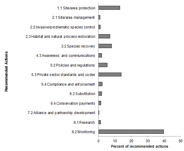
Long description for Figure 7
| Conservation Action | % |
|---|---|
| 1.1 Site/area protection | 13 |
| 2.1 Site/area management | 1 |
| 2.2 Invasive/problematic species control | 1 |
| 2.3 Habitat and natural process restoration | 7 |
| 3.2 Species recovery | 8 |
| 4.3 Awareness and communications | 2 |
| 5.2 Policies and regulations | 5 |
| 5.3 Private sector standards and codes | 14 |
| 5.4 Compliance and enforcement | 2 |
| 6.2 Substitution | 2 |
| 6.4 Conservation payments | 2 |
| 7.2 Alliance and partnership development | 0 |
| 8.1 Research | 1 |
| 8.2 Monitoring | 40 |
References
Aboriginal Affairs and Northern Development Canada. 2010. Aboriginal peoples in Quebec [On line]. (Accessed 9 October 2013).
Aubry, Y. and R. Cotter. 2007. Québec Shorebird Conservation Plan. Environment and Climate Change Canada, Canadian Wildlife Service, Québec region, Sainte-Foy, xvi + 196 p.
Bourdages, H., and J.-F. Ouellet. 2011. Répartition géographique et indices d’abondance des poissons marins du nord du golfe du Saint-Laurent(1990-2009). Rapp. tech. can. sci. halieut. aquat. 2963 : vi + 171 p.
Chapdelaine, G. and J.-F. Rail. 2004. Québec's Waterbird Conservation Plan. Migratory Bird Division, Canadian Wildlife Service, Québec region, Environment and Climate Change Canada, Sainte-Foy, Québec. 99 p.
Commission de toponymie Québec. 2012. Banque de noms et de lieux du Québec [On line] (Accessed 10 October 2012). [Available in French only]
Donaldson, G. M., C. Hyslop, R. I. G. Morrison, H. L. Dickson, and I. Davidson (editors). 2000. Canadian Shorebird Conservation Plan. Canadian Wildlife Service, Environment and Climate Change Canada, Ottawa, Ontario. 27pp.
Drolet, B., V. Carignan, M.-A. Vaillancourt and G. Falardeau. 2010. Plan de conservation des oiseaux terrestres du Québec : volume 1, oiseaux des milieux forestiers. Unpublished working document, Environment and Climate Change Canada, Canadian Wildlife Service, Québec region.
Ecological Stratification Working Group. 1996. A National Ecological Framework for Canada. Agriculture and Agri-Food Canada, Research Branch, Centre for Land and Biological Resources Research and Environment and Climate Change Canada, State of the Environment Directorate, Ecozone Analysis Branch, Ottawa/Hull. Report and national map at 1:7500 000 scale.
Falardeau, G., V. Carignan, B. Drolet and M.-A. Vaillancourt. 2010. Plan de conservation des oiseaux terrestres du Québec, volume 2 : les oiseaux des milieux agricoles, humides, urbains, arctiques, alpins et des falaises. Unpublished working document, Environment and Climate Change Canada, Canadian Wildlife Service, Québec region.
Food and Agriculture Organization (FAO). 2000. Land cover classification system. United Nations Food and Agriculture Organization, Rome.
Gouvernement du Québec. 2002. Portrait général de l'eau. (Accessed 9 October 2013). [Available in French only]
Gouvernement du Québec. 2013. Le Nord pour tous. (Accessed 18 July 2013).
Kennedy, J.A., E.A. Krebs and A.F. Camfield. 2012. A Manual for Completing All-bird Conservation Plans in Canada, April 2012 version. Canadian Wildlife Service, Environment and Climate Change Canada. Ottawa, ON
Lepage, C., D. Bordage, D. Dauphin, F. Bolduc and B. Audet. In preparation. Plan de conservation de la sauvagine du Québec, 2010. Environment and Climate Change Canada, Canadian Wildlife Service, Quebec region, Quebec.
Li, T. and J.-P. Ducruc. 1999. Les provinces naturelles. Niveau I du cadre écologique de référence du Québec. Ministère de l'Environnement. (Accessed 10 October 2012). [Available only in French]
Milko, R., L. Dickson, R. Elliot, and G. Donaldson. 2003. Wings Over Water: Canada's Waterbird Conservation Plan. Canadian Wildlife Service, Environment and Climate Change Canada, Ottawa, Ontario. 28pp.
Ministère des Ressources naturelles. 2013.Zones de végétation et domaines bioclimatiques du Québec [On line]. (Accessed 28 February 2013). [Available in French only]
Ministère du Développement durable, de l’Environnement, de la Faune et des Parcs. 2013. Liste des espèces désignées menacées ou vulnérables au Québec. [On line] (Accessed 4 April 2013). [Available in French only]
National Audubon Society. 2009. Birds and Climate Change - Ecological Disruption in Motion. 16 pages.
North American Waterfowl Management Plan, Plan Committee. 2004. North American Waterfowl Management Plan 2004. Implementation Framework: Strengthening the Biological Foundation. Canadian Wildlife Service, U.S. Fish and Wildlife Service, Secretaria de Medio Ambiente y Recursos Naturales, 106 pp.
Panjabi, A. O., E. H. Dunn, P. J. Blancher, W. C. Hunter, B. Altman, J. Bart, C. J. Beardmore, H. Berlanga, G. S. Butcher, S. K. Davis, D. W. Demarest, R. Dettmers, W. Easton, H. Gomez de Silva Garza, E. E. Iñigo-Elias, D. N. Pashley, C. J. Ralph, T. D. Rich, K. V. Rosenberg, C. M. Rustay, J. M. Ruth, J. S. Wendt, and T. C. Will. 2005. The Partners in Flight Handbook on Species Assessment.Version 2005 (PDF, 406, KB). Partners in Flight Technical Series No. 3. Rocky Mountain Bird Observatory website.
Rich, T.D., C.J. Beardmore, H. Berlanga, P.J. Blancher, M.S.W. Bradstreet, G.S. Butcher, D.W. Demarest, E.H. Dunn, W.C. Hunter, E.E. Iñigo-Elias, J.A. Kennedy, A.M. Martell, A.O. Panjabi, D.N. Pashley, K.V. Rosenberg, C.M. Rustay, J.S. Wendt and T.C. Will. 2004. Partners in Flight North American Landbird Conservation Plan. Cornell Lab of Ornithology. Ithaca (NY).
Species at Risk Public Registry. Accessed 4 April 2012. Schedule 1: List of Wildlife Species at Risk. (Accessed 10 October 2012).
Statistics Canada. 2012. Population and dwelling counts, for Canada, provinces and territories, and census subdivisions (municipalities), 2011 and 2006 censuses [On line]. (Accessed 10 October 2012).