
Bird Conservation Strategy for region 9 in Canada
- Abridged version -
February 2013

The abridged version of the strategy available here contains a summary of the results, but does not include an analysis of conservation needs by habitat, a discussion of widespread conservation issues, or the identification of research and monitoring needs.
To obtain a copy of the full version of this strategy, please contact migratorybirds_oiseauxmigrateurs@ec.gc.ca.
Table of contents
- Preface
- Acknowledgements
- Bird Conservation Strategy for Bird Conservation Region 9 Pacific and Yukon Region: Great Basin
- Executive summary
- Introduction: Bird Conservation Strategies
- Section 1: Summary of Results - All Birds, All Habitats
- References
List of figures
- Figure 1. Landcover in BCR 9 Pacific and Yukon Region
- Figure 2. Map of protected and designated areas in BCR 9 Pacific and Yukon Region
- Figure 3. Percent of priority species that are associated with each habitat type in BCR 9 Pacific and Yukon Region
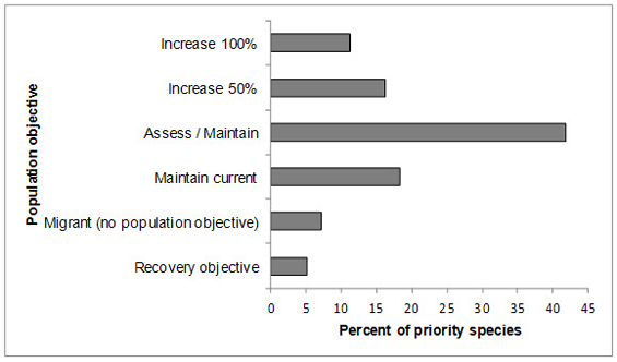
- Figure 4. Percent of priority species that are associated with each population objective category in BCR 9 Pacific and Yukon Region: Great Basin
- Figure 5. Percent of identified threats to priority species within BCR 9 Pacific and Yukon by threat sub-category
- Figure 6. Percent of all conservation objectives assigned to each conservation objective category in BCR 9 Pacific and Yukon Region
- Figure 7. Percent of recommended actions assigned to each sub-category in BCR 9 Pacific and Yukon Region
List of tables
- Table 1. Priority species in BCR 9 Pacific and Yukon Region, population objective, and the reason for priority status
- Table 2. Summary of priority species, by bird group, in BCR 9 Pacific and Yukon Region
- Table 3. Number of priority species in BCR 9 Pacific and Yukon Region by reason for priority status
- Table 4. Relative magnitude of identified threats to priority species within BCR 9 Pacific and Yukon by threat category and broad habitat class
Preface
Environment and Climate Change Canada led the development of all-bird conservation strategies in each of Canada’s Bird Conservation Regions (BCRs) by drafting new strategies and integrating new and existing strategies into an all-bird framework. These integrated all-bird conservation strategies will serve as a basis for implementing bird conservation across Canada, and will also guide Canadian support for conservation work in other countries important to Canada’s migrant birds. Input to the strategies from Environment and Climate Change Canada’s conservation partners is as essential as their collaboration in implementing their recommendations.
Environment and Climate Change Canada has developed national standards for strategies to ensure consistency of approach across BCRs. Bird Conservation Strategies will provide the context from which specific implementation plans can be developed for each BCR, building on the programs currently in place through Joint Ventures or other partnerships. Landowners including Aboriginal peoples will be consulted prior to implementation.
Conservation objectives and recommended actions from the conservation strategies will be used as the biological basis to develop guidelines and beneficial management practices that support compliance with regulations under the Migratory Birds Convention Act, 1994.
Acknowledgements
Ivy Whitehorne, Paul Levesque, Veronique Connolly, Tanya Luszcz, Alicia Newbury and Elsie Krebs were the main authors of this document. This strategy follows templates developed by Alaine Camfield, Judith Kennedy and Elsie Krebs with the help of the BCR planners in each of the Canadian Wildlife Service regions throughout Canada. However, work of this scope cannot be accomplished without the contribution of other colleagues who provided or validated technical information, commented on earlier draft versions of the strategy, and supported the planning process. We would like to thank the following people: André Breault, Rob Butler, Dick Cannings, Krista De Groot, Wendy Easton, Kevin Fort, Bruce Harrison, Nancy Mahony and Kathleen Moore.
Bird Conservation Strategy for Bird Conservation Region 9 Pacific and Yukon Region: Great Basin
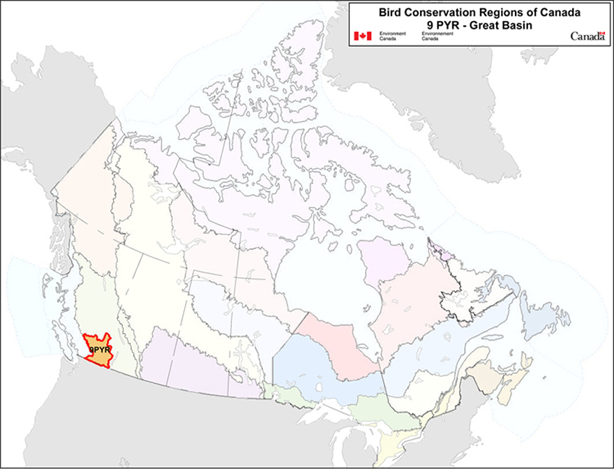
Text Description for map of BCR 9
Map of the Bird Conservation Regions of Canada, with BCR 9, Pacific and Yukon Region: Great Basin highlighted in light orange with a red outline.
Map of the Bird Conservation Regions (BCR’s) of Canada with BCR 9, Pacific and Yukon Region: Great Basin highlighted in light orange with a red outline. Canada (with Alaska, Greenland and the northern portion of the United States of America also appearing, in grey) is shown very washed out, as it is only present to provide context for the location of the highlighted BCR 9. The washed out Canadian map is divided by BCR (12 Canadian BCRs in total), with various colours, and their exact locations and sizes are indistinguishable, aside from BCR 9. The highlighted BCR 9 occurs in southern British Columbia and lies in the rain shadow of the Cascade Range to its’ west, is bounded by the Columbia Mountains in the east, and extends north to the southern edge of the central interior plateau of British Columbia. The following legend appears in the top right corner of the map: “Bird Conservation Regions of Canada. 9 PYR - Great Basin” and includes the Environment and Climate Change Canada logo, and the Government of Canada logo.
Executive summary
Bird Conservation Region (BCR) 9, the Great Basin, is a dry and cold northern desert extending south from south-central British Columbia through portions of six states: Washington, Oregon, Idaho, California, Utah and most of Nevada. The Canadian portion of BCR 9 is about 5.7 million ha in size and lies in the rain shadow of the Cascade Range to its west, is bounded by the Columbia Mountains in the east, and extends north to the southern edge of the central interior plateau of British Columbia. Dominant physiographic features of the region include mountains and high-elevation plateaus, with moist montane-boreal communities, and prominent lowland valleys and basins, which serve as reservoirs for semi-arid grasslands, shrubsteppe and dry woodland communities. Some of these ecosystems are found nowhere else in Canada. BCR 9 contains much of the remaining grasslands, shrubsteppe, and low elevation dry forests in British Columbia.
This conservation strategy for BCR 9 in the Pacific and Yukon Region (PYR) builds on existing bird conservation strategies and complements those created for the other BCRs across Canada. BCR strategies will serve as a framework for implementing bird conservation nationally, and also identify international conservation issues for Canada’s priority birds. This strategy is not intended to be highly prescriptive, but rather is intended to guide future implementation efforts undertaken by various partners and stakeholders.
BCR 9 is one of the most diverse regions in Canada. Two hundred and fifty-nine (259) species of birds regularly breed, overwinter, reside year-round or routinely migrate through the region. It also has a disproportionately high number of bird species considered at risk (Special Concern, Threatened or Endangered) by COSEWIC, the Committee on the Status of Endangered Wildlife in Canada. Of these, 98 species were identified as priority species. All bird groups were represented on the priority species list, although the list is dominated by landbirds (61% of the total list). The list also includes waterbirds (13%), waterfowl (19%) and shorebirds (6%). Over half of the waterfowl occurring in BCR 9 (58%) were identified as priority species, as compared to 42% of the waterbirds, 35% of the landbirds and only 24% of shorebirds. Forty-six percent (46%) of the priority species are considered at risk, either federally or provincially.
Identifying the broad habitat requirements for each priority species within the BCR allowed species to be grouped by shared habitat-based conservation issues and actions. In BCR 9, a maximum of two broad-scale habitat associations were identified for each priority species. Herbaceous habitats (grassland, shrubsteppe and agricultural areas) are used by the greatest number of priority species (37), some of which reach the northern limits of their range in the Canadian portion of BCR 9. Coniferous forests (31 species), waterbodies (30 species) and wetlands (26 species) are also widely used.
The population objectives in this strategy are categorical and are based on a quantitative or qualitative assessment of species’ population trends. If the population trend of a species is unknown, the objective is set as “assess and maintain.” Forty-two percent (42%) of priority species, with representatives from all bird groups, were assigned an objective to “assess” population status while “maintaining” current levels in the interim. For 18% of species, population levels were deemed to be at or near the objective. Sixteen percent (16%) and 11% of species were assigned objectives to increase the population by 50% and to double the population, respectively. For a small proportion of species (5%), all listed under the Species at Risk Act, we have deferred to the population objectives developed in Recovery Strategies.
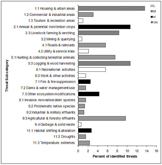
An assessment of threats identified a number of conservation issues facing priority species in the various habitats of PYR’s BCR 9. Residential and Commercial development was a major threat, especially in valley-bottom habitats (Herbaceous, Wetland, Waterbodies and Riparian). Priority species impacted by this threat include the Barn Owl, Western Screech Owl and Western Meadowlark. Threats from agricultural practices were equally significant, largely as a result of habitat loss and degradation due to the booming viticulture industry in the herbaceous (grassland and shrubsteppe) habitats of the valley bottoms, but also due to ranching and cattle-grazing practices in forested and riparian areas at all elevations. Threatened species in herbaceous habitats include the Grasshopper Sparrow, Long-billed Curlew and Bobolink, while those in forested areas include Lewis’s Woodpecker, Flammulated Owl and MacGillivray’s Warbler. Loss and degradation of forest habitats through logging and forest harvesting (coniferous, mixed and riparian) were identified as major threats. Impacted species include Olive-sided Flycatcher, Black-backed Woodpecker and Northern Goshawk. Natural system modifications, in the form of the mountain pine beetle outbreak in coniferous and mixed forests (e.g., Purple Finch, Dusky Flycatcher, Pygmy Nuthatch), and fire suppression in lower-elevation coniferous forest and herbaceous habitats (e.g., Lark Sparrow, Sage Thrasher, Sharp-tailed Grouse), also emerged as high-level threats. Another high-level threat was pollution, chiefly associated with the use of pesticides in the agricultural sector, which may increase mortality directly through exposure (e.g., Horned Lark, Double-crested Cormorant), or indirectly through reduction of prey availability (e.g., White-throated Swift, Barn Swallow).
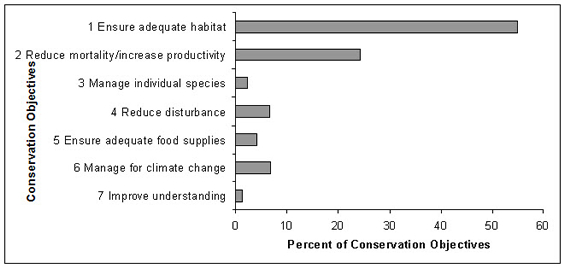
Conservation objectives were designed to address threats and information gaps that were identified for priority species.They describe the environmental conditions, and research and monitoring, that are thought to be necessary for progress towards population objectives and to understand underlying conservation issues for priority bird species. The majority of conservation objectives for BCR 9 relate to maintaining or enhancing habitat quality and quantity. Included in these objectives are the maintenance of the full range of naturally occurring habitat types, maintaining the quality of existing habitats and retaining important features on the landscape (e.g., standing dead snags for cavity-nesting birds). Also important is the need to reduce mortality of priority species, which includes reducing collisions with human-made structures, pesticide poisoning, mortality caused by ingestion of lead shot, destruction of nests and illegal harvest. Other objectives address the need to manage impacts of climate change and to reduce human disturbance of breeding birds.
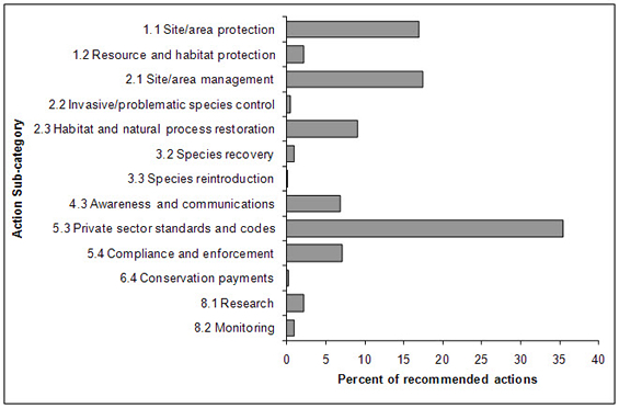
Recommended actions indicate on-the-ground activities that will help to achieve the conservation objectives. Actions are strategic rather than highly detailed and prescriptive. Whenever possible, recommended actions benefit multiple species and/or respond to more than one threat. Given the prevalence of threats relating to loss and degradation of valley-bottom habitats due to development, agriculture and grazing practices, it is not surprising that habitat management and protection emerge as dominant themes. Actions relating to the development of beneficial management practices or other voluntary private sector codes of practice comprise 35% of the total recommended actions, in part because many different kinds of actions, including habitat management and protection, have aspects that relate to the development of voluntary practices. Actions recommending restoration of natural processes also were frequently suggested, driven in part by the role of fire suppression and grazing practices in altering natural cycles.
Introduction: Bird Conservation Strategies
Context
This document is one of a suite of Bird Conservation Region Strategies (BCRstrategies) that have been drafted by Environment and Climate Change Canada for all regions of Canada. These strategies respond to Environment and Climate Change Canada’s need for integrated and clearly articulated bird conservation priorities to support the implementation of Canada’s migratory birds program, both domestically and internationally. This suite of strategies builds on existing conservation plans for the four “bird groups” (waterfowl Footnote1, waterbirdsFootnote2, shorebirdsFootnote3 and landbirdsFootnote4) in most regions of Canada, as well as on national and continental plans, and includes birds under provincial/territorial jurisdiction. These new strategies also establish standard conservation planning methods across Canada, and fill gaps, as previous regional plans do not cover all areas of Canada or all bird groups.
These strategies present a compendium of required actions based on the general philosophy of achieving scientifically-based desired population levels as promoted by the four pillar initiatives of bird conservation. Desired population levels are not necessarily the same as minimum viable or sustainable populations, but represent the state of the habitat/landscape at a time prior to recent dramatic population declines in many species from threats known and unknown. The threats identified in these strategies were compiled using currently available scientific information and expert opinion. The corresponding conservation objectives and actions will contribute to stabilizing populations at desired levels.
The BCRstrategies are not highly prescriptive. In most cases, practitioners will need to consult additional information sources at local scales to provide sufficient detail to implement the recommendations of the strategies. Tools such as beneficial management practices will also be helpful in guiding implementation. Partners interested in participating in the implementation of these strategies, such as those involved in the habitat Joint Ventures established under the North American Waterfowl Management Plan (NAWMP), are familiar with the type of detailed implementation planning required to coordinate and undertake on-the-ground activities.
Strategy Structure
Section 1 of this strategy, published here, presents general information about the BCR and the subregion, with an overview of the six elementsFootnote5 that provide a summary of the state of bird conservation at the sub-regional level. Section 2, included in the full strategy, provides more detail on the threats, objectives and actions for priority species grouped by each of the broad habitat types in the subregion. Section 3, also part of the full strategy, presents additional widespread conservation issues that are not specific to a particular habitat or were not captured by the threat assessment for individual species, as well as research and monitoring needs, and threats to migratory birds while they are outside of Canada. The approach and methodology are summarized in the appendices of the full strategy, but details are available in a separate document (Kennedy et al. 2012). A national database houses all the underlying information summarized in this strategy and is available from Environment and Climate Change Canada.
Characteristics of Bird Conservation Region 9: Great Basin
Bird Conservation Region (BCR) 9, the Great Basin, is a dry and cold northern desert extending south from south-central British Columbia through portions of six states: Washington, Oregon, Idaho, California, Utah and most of Nevada (Partners in Flight British Columbia and Yukon 2003; Bird Studies Canada 2001). The Canadian portion of BCR 9 is about 5.7 million ha in size and lies in the rain shadow of the Cascade Range to its west, is bounded the Columbia Mountains in the east, and extends north to the southern edge of the central interior plateau of British Columbia (Brussard et al. 1995; Bird Studies Canada 2001; Fig. 1). In Canada, BCR 9 corresponds to BC’s Southern Interior Ecoprovince (5.65 million ha). Dominant physiographic features of the ecoprovince include mountains and high-elevation plateaus, with moist montane-boreal communities, and prominent lowland valleys and basins, which serve as reservoirs for semi-arid grasslands, shrubsteppe and dry woodland communities (Lloyd et al.1990). Some of these ecosystems are found nowhere else in Canada (Pryce et al. 2006). BCR 9 contains much of the remaining grasslands, shrubsteppe, and low elevation dry forests in British Columbia. BCR 9 is one of the most diverse regions in Canada with 259 species of birds that regularly breed, overwinter, reside year-round, or routinely migrate through the region. It also has a disproportionately high number of bird species (n=19) considered at risk (either Special Concern, Threatened, or Endangered) by COSEWIC. About 10% (over 550 000 ha) of the BCR is contained within parks or other protected areas (CIJV Technical Committee 2010; Fig. 2).
The climate and natural resources of BCR 9 have attracted intensive land use in the form of urban, industrial and agricultural development, mainly in valley bottoms. Most development in the BCR is concentrated in the Okanagan and Thompson valleys, where the two major urban centres are found (Kelowna, pop.162,000 and Kamloops, pop. 93,000; Statistics Canada 2008). The cumulative impacts of this development, as well as widespread grazing by livestock, fire suppression and invasion of non-native plants have severely degraded the integrity of natural habitats for landbirds and other taxa in BCR 9. For example, approximately one quarter of the historic grasslands in BCR 9 have been lost to development and agricultural conversion (Grasslands Conservation Council of BC 2004), and 67% of the landbase of BCR 9 is under grazing tenure (Sara Loos, NCC, pers. comm.). The current outbreak of mountain pine beetle in BCR 9, and the resultant loss of mature pine forest to both the beetle and salvage logging activity also pose unique conservation problems to a number of priority species.
Figure 1. Landcover in BCR 9 Pacific and Yukon Region.
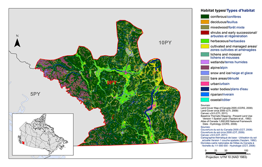
Text Description for Figure 1
Map of the landcover in BCR 9 Pacific and Yukon Region: Great Basin. The various habitat types that exist in BCR 9 are shown in various colours.
Map of the landcover in BCR 9 Pacific and Yukon Region: Great Basin. The map’s extent includes southern British Columbia and the extreme northern portion of Washington State. The borders of BCR 5PY, 9PY and 10PY are delineated. BCR 9 appears in colour (with a thick red line indicating its borders) while the others appear in grey. Inset in the lower left corner is a map of Canada with BCR 9 highlighted in red.
BCR 9 occurs in southern British Columbia and lies in the rain shadow of the Cascade Range to its’ west, is bounded by the Columbia Mountains in the east, and extends north to the southern edge of the central interior plateau of British Columbia.
The various habitat types that exist in the BCR are shown on the map in various colours, which are explained in the following bilingual legend (appearing to the right of the map):
- Coniferous/conifères
- Deciduous/feuillus
- Mixedwood/forêt mixte
- Shrubs and early successional/arbustes et regeneration
- Herbaceous/herbacées
- Cultivated and managed areas/zone cultivées et aménagées
- Lichens and mosses/lichens et mousses
- Wetlands/terres humides
- Alpine/alpin
- Snow and ice/neige et glace
- Bare areas/denude
- Urban/urbain
- Water bodies /plans d’eau
- Riparian/riverain
- Coastal/côtier
The most common habitat types visible at this scale in BCR 9 are coniferous forests throughout and herbaceous/cultivated valleys. Several waterbodies are visible, namely two rivers (one east-west and one north-south) which cross in the centre-north part of the BCR, and a long narrow lake in the north-south direction located in the centre-east area of the BCR. The northwest portion of the BCR is predominantly alpine habitat. The other habitat types occur in smaller concentrations throughout the BCR, except for costal, which is absent.
The remaining text in the legend is the following: Sources: Land Cover Map of Canada 2005 (CCRS, 2008), Land Cover circa 2000 (CTI, 2009), Canvec v 9.0 (CTI, 2011), Baseline Thematic Mapping - Present Land Use Version 1 Spatial Layer (Yazdani et al., 1992), Atlas of Canada 1,000,000 National Framework Data - Hydrology (CCRS, 2008). Sources: Couverture du sol du Canada 2005 (CCT, 2008), Couverture du sol circa 2000 (CIT, 2009), Canvec v 9.0 (CIT, 2011), Cartographe thématique de base - Utilisation du sol actuelle Version 1 couche spatiale (Yazdani, 1992), Données-cadre nationales de l’Atlas du Canada à l’échelle du 1/1 000 000 - Hydrologie (CCT, 2008). There is also a visual representation of scale for the map in the legend which indicates 0, 25, 50 and 100 kms. The Projection is UTM 10 (NAD 1983).
Urban, industrial and agricultural development continues to threaten remaining native habitats in BCR 9. Water availability is going to be a major issue as the human population increases, especially in the Okanagan Basin, which has the lowest per capita availability of freshwater in Canada (Statistics Canada 2003). Climate change is also expected to have broad impacts across the BCR, particularly in wetland habitats (CIJV Technical Committee 2010).
Figure 2. Map of protected and designated areas in BCR 9 Pacific and Yukon Region.
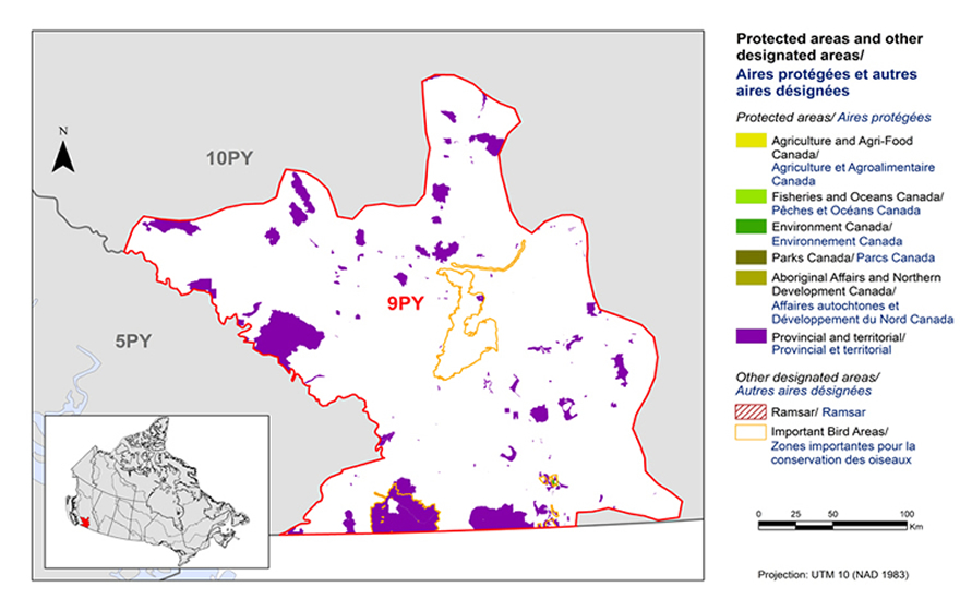
Text Description for Figure 2
Map of protected and designated areas in BCR 9 Pacific and Yukon Region: Great Basin. The map’s extent includes southern British Columbia and the extreme northern portion of Washington State. The borders of BCR 5PY, 9PY and 10PY are delineated. BCR 9 appears in colour (with a thick red line indicating its borders) while the others appear in grey. Inset in the lower left corner is a map of Canada with BCR 9 highlighted in red. BCR 9 occurs in southern British Columbia and lies in the rain shadow of the Cascade Range to its’ west, is bounded by the Columbia Mountains in the east, and extends north to the southern edge of the central interior plateau of British Columbia.
The various types of protected areas that exist in the BCR are shown on the map in various colours, which are explained in the following bilingual legend (appearing to the right of the map):
Protected areas/aires protégées
- Agriculture and Agri-Food Canada/Agriculture et Agroalimentaire Canada
- Fisheries and Oceans Canada/Pêches et Océans Canada
- Environment and Climate Change Canada/Environnement et Changement climatique Canada
- Parks Canada/Parcs Canada
- Aboriginal Affairs and Northern Development Canada/Affaires autochtones et Développement du Nord Canada
- Provincial/Provincial
Other designated areas/Autres aires désignées
- Important Bird Areas/ Aires d’importance pour les oiseaux
- Ramsar/Ramsar
The most common type of protected/designated area shown is provincial, appearing as a patchwork throughout the whole BCR, with the largest areas occurring along the southern border with the U.S. and on the western border of the BCR. There are several Important Bird Areas, three of them are large: the first is a narrow east-west area in the northeast area of the BCR, the second is a large triangular area just south of the first, and the third mostly coincides with a large provincial area along the U.S. border. The other types of protected/designated areas are either absent or too small to be obvious at this scale.
There is also a visual representation of scale for the map in the legend which indicates 0, 25, 50 and 100 kms. The Projection is UTM 10 (NAD 1983).
Section 1: Summary of results - All Birds, All Habitats
Element 1: Priority species assessment
These Bird Conservation Strategies identify “priority species” from all regularly occurring bird species in each BCR subregion. Species that are vulnerable due to population size, distribution, population trend, abundance and threats are included because of their “conservation concern.” Some widely distributed and abundant “stewardship” species are also included. Stewardship species are included because they typify the national or regional avifauna and/or because they have a large proportion of their range and/or continental population in the subregion; many of these species have some conservation concern, while others may not require specific conservation effort at this time. Species of management concern are also included as priority species when they are at (or above) their desired population objectives but require ongoing management because of their socio-economic importance as game species or because of their impacts on other species or habitats.
The purpose of the prioritization exercise is to focus implementation efforts on the issues of greatest significance for Canadian avifauna. Table 1 provides a full list of all priority species and their reason for inclusion. Tables 2 and 3 summarize the number of priority species in BCR 9 Pacific and Yukon Region by bird group and by the reason for priority status.
In BCR 9, the priority species listis dominated by landbirds (60 of 98 priority species) but also includes waterbirds (13 species), waterfowl (19 species) and shorebirds (6 species). However, over half of the waterfowl occurring in BCR 9 (58%) were identified as priority species, as compared to 42% of the waterbirds, 35% of the landbirds, and only 24% of shorebirds. Forty-six percent (46%) of the priority species are considered at risk, either federally or provincially.
In BCR 9, the Canada Goose was identified as a priority species. Historically, Canada Goose populations in southern B.C. were characterized by very low densities and a scattered distribution, but through transplant programs and natural dispersal, this species has expanded its distribution and abundance in BCR 9 significantly over the last three decades (e.g., Okanagan Valley). In this plan, habitat associations, population objectives, identified threats, conservation objectives and recommended actions related to the Canada Goose refer solely to migratory populations, and do not refer to resident populations that both breed and winter in urban areas. These resident populations are responsible for a high incidence of conflicts with humans, and urban authorities (such as municipal governments) may elect to set population objectives for Canada geese and manage toward that goal through habitat modification and control measures.
Table 1. Priority species in BCR 9 Pacific and Yukon Region, population objective, and the reason for priority status. Accessible version of Table 1
| BirdGroup | TotalSpecies | Total PrioritySpecies | Percent Listed asPriority | Percent of PriorityList |
|---|---|---|---|---|
| Landbird | 170 | 60 | 35% | 61% |
| Shorebird | 25 | 6 | 24% | 6% |
| Waterbird | 31 | 13 | 42% | 13% |
| Waterfowl | 33 | 19 | 58% | 20% |
| Total | 259 | 98 | 100% |
| Reason for Priority Listinga | Landbirds | Shorebirds | Waterbirds | Waterfowl |
|---|---|---|---|---|
| COSEWICb | 19 | 1 | 1 | 0 |
| Federal SARA listedc | 16 | 1 | 0 | 0 |
| Provincially listedd | 28 | 4 | 8 | 2 |
| NAWMPe | - | - | - | 18 |
| National/Continental Concern | 14 | 4 | 1 | - |
| Regional Concern | 34 | - | - | - |
| National/Continental Stewardship | 6 | - | - | - |
| Regional Stewardship | 41 | 0 | 7f | - |
a A single species can be on the priority list for more than one reason. Note that not all reasons for inclusion apply to every bird group (indicated by “-”). See Appendix 2 for details of the species assessment process.
b COSEWIC indicates species assessed by the Committee on the Status of Endangered Wildlife in Canada as Endangered, Threatened, or Special Concern.
c Species listed on Schedule 1 of the Species at Risk Act as Endangered, Threatened, or Special Concern.
d Provincially Listed indicates species listed by the Loi sur les espèces menacées ou vulnérables (Quebec) as Threatened, Vulnerable or Likely to be designated threatened or vulnerable.
e Provincially Listed indicates species Red-listed or Blue-listed by British Columbia’s Conservation Data Centre.
f NAWMP indicates species ranked in the North American Waterfowl Management Plan (Plan Committee 2004) as having Highest, High or Moderately High breeding or non-breeding conservation and/or monitoring need in the BCR.
Element 2: Habitats important to priority species
Identifying the broad habitat requirements for each priority species within the BCR allowed species to be grouped by shared habitat-based conservation issues and actions. If many priority species associated with the same habitat face similar conservation issues, then conservation action in that habitat may support populations of several priority species. BCR strategies use a modified version of the standard land cover classes developed by the United Nations (Food and Agriculture Organization 2000) to categorize habitats and species were often assigned to more than one habitat class.
Figure 3. Percent of priority species that are associated with each habitat type in BCR 9 Pacific and Yukon Region.
Note: The total exceeds 100% because each species may be assigned to more than one habitat.
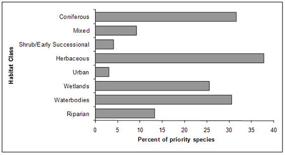
Text Description for Figure 3
A horizontal bar graph indicating the percent of priority species (x axis) that are associated with each habitat type (y axis, coniferous, mixed, shrub/early successional, herbaceous, urban, wetlands, waterbodies, riparian) in BCR 9 Pacific and Yukon region. Note: The total exceeds 100% because each species may be assigned to more than one habitat.
Element 3: Population objectives
Population objectives allow us to measure and evaluate conservation success. The objectives in this strategy are assigned to categories and are based on a quantitative or qualitative assessment of species’ population trends. If the population trend of a species is unknown, the objective is set as “assess and maintain”, and a monitoring objective is given. For any species listed under the Species at Risk Act (SARA) or under provincial/territorial endangered species legislation, Bird Conservation Strategies defer to population objectives in available Recovery Strategies and Management Plans. The ultimate measure of conservation success will be the extent to which population objectives have been reached over the next 40 years. Population objectives do not currently factor in feasibility of achievement, but are held as a standard against which to measure progress.
The population objectives in this strategy are categorical and are based on a quantitative or qualitative assessment of species’ population trends. If the population trend of a species is unknown, the objective is set as “assess and maintain”. Forty-two percent (42%) of priority species, with representatives from all bird groups, were assigned an objective to “assess” population status while “maintaining” current levels in the interim (Fig. 4). For 18% of species, population levels were deemed to be at or near the objective. Sixteen percent (16%) and 11% of species were assigned objectives to increase the population by 50% and to double the population, respectively. For a small proportion of species (5%), all SARA-listed, we have deferred to the population objectives developed in Recovery Strategies.
Figure 4. Percent of priority species that are associated with each population objective category in BCR 9 Pacific and Yukon Region: Great Basin.
Text Description for Figure 4
A horizontal bar graph indicating the percent of priority species (x axis) that are associated with each population objective (y axis; increase 100%, increase 50%, assess/maintain, maintain current, migrant, recovery objective) in BCR 9 Pacific and Yukon Region.
| Habitat | % Priority Species |
|---|---|
| Coniferous | 31.63 |
| Mixed | 9.18 |
| Shurb/Early successional | 4.08 |
| Herbaceous | 37.76 |
| Urban | 3.06 |
| Wetlands | 25.51 |
| Waterbodies | 30.61 |
| Riparian | 13.27 |
Element 4: Threat assessment for priority species
The threats assessment process identifies threats believed to have a population-level effect on individual priority species. These threats are assigned a relative magnitude (Low, Medium, High, Very High), based on their scope (the proportion of the species’ range within the subregion that is impacted) and severity (the relative impact on the priority species’ population). This allows us to target conservation actions towards threats with the greatest effects on suites of species or in broad habitat classes. Some well known conservation issues (such as predation by domestic cats or climate change) may not be identified in the literature as significant threats to populations of an individual priority species and therefore may not be captured in the threat assessment. However, they merit attention in conservation strategies because of the large numbers of individual birds affected in many regions of Canada. We have incorporated them in a separate section on Widespread Issues (see complete version of strategy) but, unlike other threats, they are not ranked.
An assessment of threats identified a number of conservation issues facing priority species in the various habitats of PYR’s BCR 9. Residential and Commercial development was a major threat, especially in valley-bottom habitats (Herbaceous, Wetland, Waterbodies, and Riparian; Fig. 5 and Table 4). Priority species impacted by this threat include the Barn Owl, Western Screech Owl and Western Meadowlark. Threats from agricultural practices were equally significant, largely as a result of habitat loss and degradation due to the booming viticulture industry in the herbaceous (grassland and shrubsteppe) habitats of the valley bottoms, but also due to ranching and cattle-grazing practices in forested and riparian areas at all elevations. Threatened species in herbaceous habitats include the Grasshopper Sparrow, Long-billed Curlew, and Bobolink, while those in forested areas include Lewis’s Woodpecker, Flammulated Owl and MacGillivray’s Warbler. Loss and degradation of forest habitats through logging and forest harvesting (coniferous, mixed, and riparian) were identified as major threats. Impacted species include Olive-sided Flycatcher, Black-backed Woodpecker and Northern Goshawk. Natural system modifications, in the form of the mountain pine beetle outbreak in coniferous and mixed forests (e.g., Purple Finch, Dusky Flycatcher, Pygmy Nuthatch), and fire suppression in lower elevation coniferous forest and herbaceous habitats (e.g., Lark Sparrow, Sage Thrasher, Sharp-tailed Grouse), also emerged as a high-level threats. Also a high-level threat was pollution, chiefly associated with the use of pesticides in the agricultural sector, which may increase mortality directly through exposure (e.g., Horned Lark, Double-crested Cormorant), or indirectly through reduction of prey availability (e.g., White-throated Swift, Barn Swallow).
Figure 5. Percent of identified threats to priority species within BCR 9 Pacific and Yukon by threat sub-category.
Each bar represents the percent of the total number of threats identified in each sub-threat category in BCR 9 (for example, if 100 threats were identified in total for all priority species in BCR 9, and 10 of those threats were in the category 1.1 Housing and urban areas, the bar on the graph would represent this as 10%). Shading in the bars (VH = very high, H = high, M = medium and L = low) represents the rolled up magnitude of all threats in each threat subcategory in the BCR). Threats under 5.1 Hunting and collecting terrestrial animals include illegal harvest and persecution, and poisoning from ingestion of lead shot. 6.1 Recreation activities and 6.3 Work and other activities refer to the impacts of human disturbance from these activities. Threats under 7.3 Other ecosystem modifications are changes in forest structure due to the mountain pine beetle outbreak. 9.3 Agricultural and forestry effluents refers primarily to effects of pesticide use.
Text Description for Figure 5
A horizontal bar graph indicating the percent of identified threats to priority species (x axis) within BCR 9 Pacific and Yukon Region by threat subcategory (y axis; i.e. Recreational Activities, Droughts, etc).
Each bar represents the percent of the total number of threats identified in each sub-threat category in BCR 9 (for example, if 100 threats were identified in total for all priority species in BCR 9, and 10 of those threats were in the category 1.1 Housing and urban areas, the bar on the graph would represent this as 10%). Shading in the bars (VH = very high, H = high, M = medium and L = low) represents the rolled up magnitude of all threats in each threat subcategory in the BCR.
| Threat Subcategory | L | M | H | VH | Overall |
|---|---|---|---|---|---|
| 1.1 Housing and Urban areas | 13.59 | VH | |||
| 1.2 Commerical and industrial areas | 3.11 | M | |||
| 1.3 Tourism and Recreation areas | 0.97 | L | |||
| 2.1 Annual and perennial non-timber crops | 10.68 | H | |||
| 2.3 Livestock farming and ranching | 8.35 | VH | |||
| 3.2 Mining and quarrying | 0.78 | L | |||
| 4.1 Roads and railroads | 5.63 | M | |||
| 4.2 Utility and service lines | 2.14 | L | |||
| 5.1 Hunting and collecting terres trial animals | 7.57 | M | |||
| 5.3 Logging and wood harvesting | 10.68 | VH | |||
| 6.1 Recreational activities | 5.63 | L | |||
| 6.3 Work and other activities | 1.55 | L | |||
| 7.1 Fire and fire suppression | 2.52 | H | |||
| 7.2 Dams and water management/use | 1.55 | M | |||
| 7.3 Other ecosystems modifications | 4.27 | H | |||
| 8.1 Invasive non-native/alien species | 1.55 | M | |||
| 8.2 Problematic native species | 1.36 | M | |||
| 9.2 Industrial and military effluents | 1.17 | M | |||
| 9.3 Agriculture and forestry effluents | 9.71 | M | |||
| 9.4 Garbage and solid waste | 0.58 | L | |||
| 11.1 Habitats hifting and alteration | 2.72 | H | |||
| 11.2 Droughts | 1.55 | M | |||
| 11.3 Temperature extremes | 2.33 | M |
| Threat category | Habitat class Coniferous |
Habitat class Mixed |
Habitat class Shrub/ Early Successional |
Habitat class Herbaceous |
Habitat class Urban |
Habitat class Wetlands |
Habitat class Waterbodies |
Habitat class Riparian |
Habitatclass Overall |
|---|---|---|---|---|---|---|---|---|---|
| Overall | VH | H | L | VH | M | H | H | VH | |
| 1 Residential and commercial development |
M | M | L | VH | H | H | M | VH | VH |
| 2 Agriculture and aquaculture | H | H | VH | H | L | H | VH | ||
| 3 Energy production and mining | L | L | L | L | |||||
| 4 Transportation & service corridors |
M | L | L | M | M | L | M | L | M |
| 5 Biological resource use | VH | VH | M | M | M | L | L | H | VH |
| 6 Human intrusions and disturbance | L | L | M | L | M | L | M | ||
| 7 Natural system modifications | H | H | VH | M | M | M | M | H | |
| 8. Invasive and other problematic species and genes |
M | H | L | L | H | H | |||
| 9. Pollution | M | L | L | H | L | H | H | L | H |
| 11. Climate change and severe weather | H | M | M | L | H | M | M | H |
Threats to priority species while they are outside Canada during the non-breeding season were also assessed and are presented in the Threats Outside of Canada section (see complete version of the strategy).
Element 5: Conservation objectives
Conservation objectives were designed to address threats and information gaps that were identified for priority species. They describe the environmental conditions and research and monitoring that are thought to be necessary for progress towards population objectives and to understand underlying conservation issues for priority bird species. As conservation objectives are reached they will collectively contribute to achieving population objectives. Whenever possible, conservation objectives were developed to benefit multiple species, and/or respond to more than one threat.
The majority of conservation objectives for BCR 9 relate to maintaining or enhancing habitat quality and quantity (Fig. 6). Included in these objectives are the maintenance of the full range of naturally-occurring habitat types, maintaining the quality of existing habitats, and retaining important features on the landscape (e.g., standing dead snags for cavity nesting birds). Also important is the need to reduce mortality of priority species, which includes reducing collisions with man-made structures, pesticide poisoning, mortality caused by ingestion of lead shot, destruction of nests, and illegal harvest. Other objectives address the need to manage impacts of climate change, and reduce human disturbance of breeding birds.
Figure 6. Percent of all conservation objectives assigned to each conservation objective category in BCR 9 Pacific and Yukon Region.
Text Description for Figure 6
A horizontal bar graph indicating the percent of all conservation objectives (x axis) assigned to each conservation objective category (y axis; i.e. ensure adequate habitat, reduce disturbance, etc) in BCR 9 Pacific and Yukon Region.
| Conservation Objectives | Percent |
|---|---|
| 1. Ensure adequate habitat | 54.45% |
| 2. Reduse mortality/increase productivity | 25.10% |
| 3. Manage individual | 2.23% |
| 4. Reduse disturbance | 6.28% |
| 5. Ensure adequate food supplies | 3.85% |
| 6. Manage for climate change | 6.88% |
| 7. Improve understanding | 1.21% |
Element 6: Recommended actions
Recommended actions indicate on-the-ground activities that will help to achieve the conservation objectives (Fig. 7). Actions are strategic rather than highly detailed and prescriptive. Whenever possible, recommended actions benefit multiple species, and/or respond to more than one threat. Recommended actions defer to or support those provided in recovery documents for species at risk at the federal, provincial or territorial level, but will usually be more general than those developed for individual species.
Given the prevalence of threats relating to loss and degradation of valley-bottom habitats due to development, agriculture and grazing practices, it is not surprising that habitat management and protection emerge as dominant themes. Actions relating to the development of beneficial management practices (BMPs) or other voluntary private sector codes of practice comprise 35% of the total recommended actions, in part because many different kinds of actions, including habitat management and protection, have aspects that relate to the development of voluntary beneficial practices. Actions recommending restoration of natural processes also were frequently suggested, driven in part by the role of fire suppression and grazing practices in altering natural cycles.
Figure 7. Percent of recommended actions assigned to each sub-category in BCR 9 Pacific and Yukon Region.
“Research” and “monitoring” refers to specific species where additional information is required. 8.1 Research and 8.2 Monitoring refer to specific species where information is required before conservation actions can be formulated. For a discussion of broad-scale research and monitoring requirements, see the section on Research and Monitoring Needs in the complete version of the strategy.
Text Description for Figure 7
A horizontal bar graph indicating the percent of recommended action (x axis) assigned to each sub-category of recommended actions (y axis; i.e. Site/area protection, Species Recovery, etc) in BCR 9 Pacific and Yukon Region.
| Conservation action | Percent |
|---|---|
| 1.1 Site/area proctection | 16.89% |
| 1.2 Resource and habitat protection | 2.19% |
| 2.1 Site/area management | 17.50% |
| 2.2 Invasive/problematic species control | 0.49% |
| 2.3 Habitat and natural process restoration | 9.11% |
| 3.2 Species recovery | 0.97% |
| 3.3 Species reintroduction | 0.12% |
| 4.3 Awareness and communications | 6.80% |
| 5.3 Private sector standards and codes | 35.48% |
| 5.4 Compliance and enforcement | 7.05% |
| 6.4 Conservation payments | 0.24% |
| 8.1 Research | 2.19% |
| 8.2 Monitoring | 0.97% |
References
Bird Studies Canada. 2001. North American Bird Conservation Initiative, Canadian Bird Conservation Regions: BCR 9 (Great Basin).Accessed 30 November 2010.
Brussard, P. F., D. Charlet, and D. S. Dobkin. 1995. Status and trends for the Great Basin and Mojave Desert Region.University of Nevada. Biological Resources Research Center, Reno, Nevada. Great Basin-Mojave Desert Region (PDF, 3.33 MB). Accessed 30 November 2010.
CIJV. 2003. The Canadian Intermountain Joint Venture: Biological Foundation and Prospectus. Canadian Intermountain Joint Venture. 71pp.
CIJVTechnical Committee. August 2010. Canadian Intermountain Joint Venture Implementation Plan: Wetlands and Associated Species.viii+ 64pp.
Donaldson, G. M., C. Hyslop, R. I. G. Morrison, H. L. Dickson, and I. Davidson (editors). 2000. Canadian Shorebird Conservation Plan. Canadian Wildlife Service, Environment and Climate Change Canada, Ottawa, Ontario. 27pp.
Food and Agriculture Organization (FAO). 2000. Land cover classification system. United Nations Food and Agriculture Organization, Rome.
Grasslands Conservation Council of BC. 2004. BC Grasslands Mapping Project: A Conservation Risk Assessment. Final Report.
Kennedy, J.A., E.A. Krebs and A.F. Camfield. 2012. A Manual for Completing All-bird Conservation Plans in Canada, April 2012 version. Canadian Wildlife Service, Environment and Climate Change Canada. Ottawa, ON.
Lloyd, D., K. Angrove, G. Hope, and C. Thompson. 1990. A Field Guide to Site Identification and Interpretation for the Kamloops Forest Region, Vols. 1 and 2. British Columbia Ministry of Forests, Kamloops. Land Management Handbook No. 23. 398pp.
Milko, R., L. Dickson, R. Elliot, and G. Donaldson. 2003. Wings Over Water: Canada’s Waterbird Conservation Plan. Canadian Wildlife Service, Environment and Climate Change Canada, Ottawa, Ontario. 28pp.
North American Waterfowl Management Plan, Plan Committee. 2004. North American Waterfowl Management Plan 2004.Implementation Framework: Strengthening the Biological Foundation. Canadian Wildlife Service, U.S. Fish and Wildlife Service, Secretaria de Medio Ambiente y Recursos Naturales, 106pp.
Partners in Flight British Columbia and Yukon. 2003. Canada’s Great Basin Landbird Conservation Plan, Version 1.0. Partners in Flight British Columbia and Yukon, Delta, British Columbia, Canada. 100pp.
Pryce, B., P. Iachetti, G. Wilhere, K. Ciruna, J. Floberg, R. Crawford, R. Dye, M. Fairbarns, S. Farone, S. Ford, M. Goering, M. Heiner, G. Kittel, J. Lewis, D. Nicolson, and N. Warner. 2006. Okanagan Ecoregional Assessment, Volume 1 - Report.Prepared by Nature Conservancy of Canada, The Nature conservancy of Washington, and the Washington Department of Fish and Wildlife with support from the British Columbia Conservation Data Centre, Washington Department of Natural Resources Natural Heritage Program, and NatureServe. Nature Conservancy of Canada, Victoria, British Columbia.
Rich, T.D., C.J. Beardmore, H. Berlanga, P.J. Blancher, M.S.W. Bradstreet, G.S. Butcher, D.W. Demarest, E.H. Dunn, W.C. Hunter, E.E. Iñigo-Elias, J.A. Kennedy, A.M. Martell, A.O. Panjabi, D.N. Pashley, K.V. Rosenberg, C.M. Rustay, J.S. Wendt, and T.C. Will. 2004. Partners in Flight North American Landbird Conservation Plan. Cornell Lab of Ornithology. Ithaca, NY.
Rocky Mountain Bird Observatory. 2005. Partners in Flight Species Assessment database (online).
Species at Risk Public Registry. Accessed 4 April 2012. Schedule 1: List of Wildlife Species at Risk.
Statistics Canada. 2008. 2006 Community Profiles. Statistics Canada Catalogue no. 92-591-XWE. Ottawa. Released July 24, 2008.
Statistics Canada. 2003. Human activity and the environment. Annual Statistics 2003. Cat. No. 16-201-XIE, P.8.