
Eleanor Island National Wildlife Area management plan
Table of contents
- About Environment Canada's Protected Areas and Management Plans
- Eleanor Island National Wildlife Area (NWA)
- 1. Description of the Protected Area
- 2. Ecological resources
- 3. Management challenges and threats
- 4. Goals and objectives
- 5. Management approaches
- 6. Authorisations and prohibitions
- 7. Health and safety
- 8. Enforcement
- 9. Plan implementation
- 10. Collaborators
- 11. Literature cited
- Appendix I: Canadian Wildlife Service (Ontario) Conditions of Research Requests in National Wildlife Areas
- Appendix II: Contacts for Eleanor Island National Wildlife Area
Document information
Acknowledgements:
This management plan was prepared by Laurie Maynard of the Canadian Wildlife Service (Ontario) of Environment Canada. The following Canadian Wildlife Service employees provided expert input and review of earlier drafts: Lesley Dunn, Andrea Kettle, David J. Moore, Jeff Robinson, and D. V. Chip Weseloh. The colonial bird data for Eleanor Island National Wildlife Area have been collected over many years by a number of observers. Appreciation is extended to D. V. Chip Weseloh, Hans Blokpoel, and Jeff Robinson of the Canadian Wildlife Service (Ontario), and volunteers with the Muskoka Field Naturalists for their efforts.
Gary B. McCullough and Janet T. Planck (Canadian Wildlife Service [Ontario]) prepared the 1985 Management Plan: Eleanor Island National Wildlife Area, which provided the groundwork for this update
Copies of this plan are available at the following addresses:
Environment CanadaInquiry Centre
10 Wellington, 23rd Floor
Gatineau QC K1A 0H3
Toll Free: 1-800-668-6767 (in Canada only)
EnviroInfo Email Environment Canada - Canadian Wildlife Service
Ontario Region
4905 Dufferin Street
Toronto ON M3H 5T4
Website for Environment Canada Protected Areas.
How to cite this document:
Environment Canada. 2014. Eleanor Island National Wildlife Area Management Plan. Environment Canada, Canadian Wildlife Service, Ontario, 31 pages.
About Environment Canada's Protected Areas and Management Plans
What are Environment Canada Protected Areas?
Environment Canada establishes marine and terrestrial National Wildlife Areas for the purposes of conservation, research and interpretation. National Wildlife Areas are established to protect migratory birds, species at risk, and other wildlife and their habitats. National Wildlife Areas are established under the authority of the Canada Wildlife Act and are, first and foremost, places for wildlife. Migratory Bird Sanctuaries are established under the authority of the Migratory Birds Convention Act, 1994 and provide a refuge for migratory birds in the marine and terrestrial environment.
What is the size of the Environment Canada Protected Areas Network?
The current Protected Areas Network consists of 54 National Wildlife Areas and 92 Migratory Bird Sanctuaries comprising more than 12 million hectares across Canada.
What is a management plan?
A Management plan provides the framework in which management decisions are made. They are intended to be used by Environment Canada staff to guide decision making, notably with respect to permitting. Management is undertaken in order to maintain the ecological integrity of the protected area and to maintain the attributes for which the protected area was established. Environment Canada prepares a management plan for each protected area in consultation with First Nations and other stakeholders.
A management plan specifies activities that are allowed and identifies other activities that may be undertaken under the authority of a permit. It may also describe the necessary improvements needed in the habitat, and specify where and when these improvements should be made. A management plan identifies Aboriginal rights and allowable practices specified under land claims agreements. Further, measures carried out for the conservation of wildlife must not be inconsistent with any law respecting wildlife in the province in which the protected area is situated.
What is Protected Area Management?
Management includes monitoring wildlife, maintaining and improving wildlife habitat, periodic inspections, enforcement of regulations, as well as the maintenance of facilities and infrastructure. Research is also an important activity in protected areas; hence, Environment Canada staff carries out or coordinates research in some sites.
The series
All of the National Wildlife Areas are to have a management plan. All of these management plans will be initially reviewed 5 years after the approval of the first plan, and every 10 years thereafter.
To learn more
To learn more about Environment Canada’s protected areas, please visit our website at Protected Areas or contact the Canadian Wildlife Service.
Eleanor Island National Wildlife Area (NWA)
Eleanor Island National Wildlife Area (NWA) is an important nesting and loafing site for colonial water birds, providing refuge for the young nestlings from predators and easy access to prey in nearby waters. Eleanor Island NWA is a small, 0.6-hectare island, located approximately 1.6 km from the mainland in southern Lake Muskoka, Ontario. The island is composed of solid granite outcroppings around the perimeter and mixed coniferous forest in the interior. It supports one of the few gull and heron nesting colonies in the local area. Despite its small size, large numbers of colonial water birds breed in the spring and rest on the island throughout the summer, including the Herring Gull, Double-crested Cormorant, and Great Blue Heron.
Eleanor Island was transferred from the Corporation of the Township of Muskoka to the Canadian Wildlife Service in 1970, and in 1971 it was designated as a Migratory Bird Sanctuary (MBS) to protect colonially nesting waterbirds. In 1978, Eleanor Island was designated as a National Wildlife Area to afford greater protection for colonial nesting waterbirds and their habitat, and to serve as a site for long-term research. Given the NWA status supersedes the MBS status, Eleanor Island will be delisted as a MBS in the future.
Public access to the Eleanor Island NWA is prohibited to protect colonial nesting waterbirds and other wildlife from disturbance. Permits issued under the Canada Wildlife Act are required to conduct research, surveys and monitoring at Eleanor Island NWA and must be obtained from the Canadian Wildlife Service of Environment Canada. Lake Muskoka is a popular cottage and resort area, and the waters around the island are popular for recreational boating and fishing in the summer months. However, the rocky shoreline discourages visitors to the island itself.
There are no roads, trails or facilities on Eleanor Island NWA and thus the site maintenance requirements are minimal. Site visits are sufficient to survey and monitor the NWA. These visits entail surveying colonial nesting water birds, vegetation assessment, site inspections, and maintenance of regulatory signage.
Eleanor Island NWA is one of ten NWAs in Ontario. This management plan provides the framework for management activities to be undertaken at Eleanor Island NWA in order to achieve conservation and long-term research on colonial waterbirds. The 2013 Eleanor Island National Wildlife Area Management Plan is an update of the Management Plan: Eleanor Island National Wildlife Area (McCullough and Planck, 1985) and replaces all previous versions.
Nothing in this management plan shall be construed so as to abrogate or derogate from the protection provided for existing Aboriginal or treaty rights of the Aboriginal peoples of Canada by the recognition and affirmation of those rights in section 35 of the Constitution Act, 1982.
1. Description of the Protected Area
Eleanor Island National Wildlife Area (NWA) is a small, 0.6-hectare rocky island, located at the southern end of Lake Muskoka, approximately 1.6 km southwest of St. Elmo on the mainland (Figure 1). Eleanor Island NWA is accessible only by water. It is located in central Ontario, with the nearest towns being Bracebridge approximately 10 km northeast, and Gravenhurst approximately 7.5 km south.
The island is highest on the west side and slopes towards the east. The higher western third of the island is composed of bare, rounded granite rock, with clumps of grasses and shrubs scattered throughout (Figure 2). The eastern third and central portions of the island are vegetated with a mixture of trees, shrubs and grasses.
| Protected Area designation | National Wildlife Area |
| Province or territory | Ontario |
| Township | Township of Muskoka Lakes (formerly District Municipality of Muskoka) |
| Latitude and longitude | 44° 59’ N, 79°23’ W |
| Size | 0.6 hectares |
| Protected Area Selection Criteria (Protected Areas manual) | Criteria 1.a) - The area supports a population of a species or subspecies or a group of species which is concentrated, for any portion of the year. For this NWA:The area is an important nesting and loafing site for significant numbers of colonial waterbirds. Numerous bird species pass through the Muskoka and neighbouring Algonquin region during spring and fall migration along the Atlantic flyway. There are nesting colonial waterbirds, including Herring Gull, Double-crested Cormorant, and Great Blue Heron. It is an historic nesting site for Ring-billed Gull. Criteria 3.a) - The area is rare or unusual wildlife habitat, of a specific type in a biogeographic region. For this NWA: The island habitat provides refuge from predators for the young nestlings and is one of few remaining undeveloped islands in Lake Muskoka. |
| Protected Area Classification System (Protected Areas manual) | Species or Critical Habitat Conservation |
| International Union for Conservation of Nature (IUCN) Classification | Category 1a (Strict Nature Reserve) is defined as a “Strictly protected area set aside to protect biodiversity and also possibly geological/geomorphological features, where human visitation, use and impacts are strictly controlled and limited to ensure protection of the conservation values. Such protected areas can serve as indispensable reference areas for scientific research and monitoring” (Dudley 2008). |
| Order in council number | P.C. 1978-1439 |
| Directory of Federal Real Property (DFRP) number | 29226 |
| Gazetted | 1978 |
| Additional designations | Migratory Bird Sanctuary, North American Bird Conservation Initiative (NABCI) - Bird Conservation Region (BCR) 12, Boreal Hardwood Transition; within Boreal Shield Ecozone, Algonquin-Lake Nipissing Ecoregion. |
| Faunistic and floristic importance |
|
| Species at Risk | None recorded |
| Invasive species | None recorded |
| Management agency | Environment Canada - Canadian Wildlife Service (Ontario) |
| Public access and use | Public access is prohibited. |
| Other appropriate information | The shoreline is rocky; authorized visitors should exercise caution. |
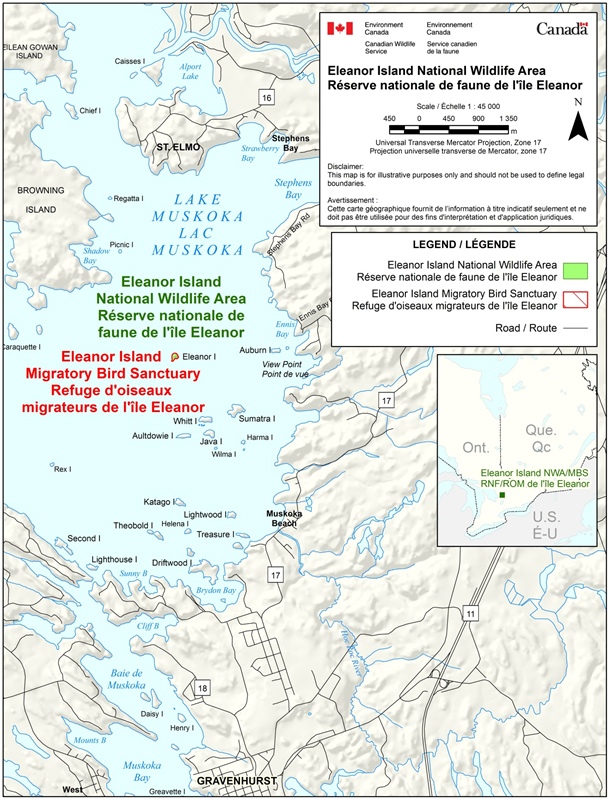
Long description for figure 1
Maps of Eleanor Island National Wildlife Area in relation to the provinces of Ontario and Quebec (inset map) and in relation to Muskoka Lake, Ontario (main map). The main map represents more clearly the National Wildlife Area’s boundaries and the Muskoka Lake area, including main towns. The main map also represents the boundaries of Eleanor Island Migratory Bird Sanctuary, which is coterminous with the National Wildlife Area. The map scale is expressed in metres.
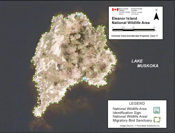
Long description for figure 2
Aerial photograph of Eleanor Island National Wildlife Area. The boundaries of the National Wildlife Area and Eleanor Island Migratory Bird Sanctuary, which are coterminous, are represented on the photograph and consist of all the shores of the island. The location of the two National Wildlife Area identification signs (one on the north side and the other on the south side) are also represented on the photograph. The photograph and its features are expressed in meters.
1.1 Regional context
Lake Muskoka is located on the Canadian Shield in central Ontario, between Georgian Bay to the west, and Algonquin Provincial Park to the east. The Muskoka region is characterized by a mix of boreal forest, exposed bedrock, and numerous lakes and islands. Lake Muskoka is the largest lake in the region and has countless islands throughout. The large majority of islands are used for cottaging.
Lake Muskoka is a two-hour drive north of Toronto, and a popular area for cottaging, recreational boating, and tourism. The shoreline and islands of Lake Muskoka are largely developed and privately-owned. The nearby towns of Bracebridge and Gravenhurst both on the mainland are important centres servicing the Muskoka region. Hardy Lake Provincial Park is located northwest of Eleanor Island NWA on the western shore of Lake Muskoka.
1.2 Historical background
The Corporation of the Township of Muskoka purchased Eleanor Island and designated it as a municipal bird sanctuary because of the nesting gulls and herons. In 1970 the Township Council, concerned that under a new regional government they would lose control of land use on the island, offered Eleanor Island to the Canadian Wildlife Service (CWS) with the understanding that the nesting colonies would be protected.
On September 1, 1970, title to Eleanor Island was transferred to the Government of Canada, and in 1971 Eleanor Island was declared a Migratory Bird Sanctuary (MBS) under the Migratory Birds Convention Act, 1994. The MBS designation was intended as an interim protective measure until the site could be designated under the forthcoming Canada Wildlife Act.
In 1978, Eleanor Island was designated as a NWA under the Canada Wildlife Act (1973) and Wildlife Area Regulations, to afford greater protection for migratory birds, other wildlife, and their habitat.
This 2013 Eleanor Island National Wildlife Area Management Plan is an update of the Management Plan: Eleanor Island National Wildlife Area (McCullough and Planck, 1985) and replaces all previous versions.
1.3 Land ownership
Eleanor Island NWA is owned and administered by the Government of Canada, specifically Environment Canada’s CWS. Eleanor Island is completely surrounded by Lake Muskoka (Figure 2), and is entirely within the province of Ontario.
1.4 Facilities and infrastructure
As there are no buildings, roads, docks or trails at Eleanor Island NWA, the maintenance requirements are minimal.
Two NWA identification signs (each 1.2 m2) are located on the northern and southern shores of the island (Table 2). Ten 0.3 m X 0.2 m boundary signs (five NWA and five MBS) and five “Entry Prohibited” signs are posted on dead trees around the perimeter of the island, to identify the site as an NWA and MBS (Table 2).
Signs are posted on dead trees because they are difficult to install in the bedrock. They require frequent maintenance and replacement due to damage from wind, rain and cold.
CWS Ontario maintains the signs and may post additional public notices at nearby boat facilities and with tourist operators, in order to identify the site as an NWA, identify that entry is prohibited, and provide contact information to report concerns.
| Type of asset | Approximate size | Responsibility |
|---|---|---|
| 2 NWA identification signs | 1.2 m X 1.2 m | Environment Canada - Canadian Wildlife Service |
| 5 NWA boundary signs | 0.3 m X 0.2 m | Environment Canada - Canadian Wildlife Service |
| 5 MBS boundary signs | 0.3 m X 0.2 m | Environment Canada - Canadian Wildlife Service |
| 5 Entry Prohibited signs | 0.3 m X 0.2 m | Environment Canada - Canadian Wildlife Service |
1.5 Socio-economic assessment
The island is not used for any commercial activity, public access is prohibited, and its rocky shoreline discourages visitation. The waters around the island are popular for recreational boating, viewing birds, and fishing in the summer months.
Although no socio-economic studies have been conducted regarding this protected area, general surveys have found that the Canadian public places a high value on habitat set aside for wildlife (Environment Canada, 1991).
2. Ecological resources
2.1 Terrestrial and aquatic habitats
The island’s vegetation is composed of a mix of deciduous and coniferous trees (27%) and shrub thicket (17%), giving way to grasses and meadow (9%) and exposed granite rock (47%).
The eastern third of the island is a mixture of Red Oak (Quercus rubra), Eastern White Cedar (Thuja occidentalis), Eastern White Pine (Pinus strobus), and various shrubs such as Canada Elderberry (Sambucus canadensis) (Figure 5). The central part of the island is a mixture of grasses and raspberry cane. The higher, western portion of the island is composed of bare, rounded granite rock with clumps of grasses and shrubs scattered throughout. The western rock face drops steeply to the water's edge. The shoreline is predominantly exposed rock, with the exception of a small stretch of cobble beach on the eastern shore of the island.
Information on vegetation species, abundance, distribution, and colonial waterbird use is limited to observations recorded during periodic site visits and colonial nesting waterbird surveys. No incidence of invasive plants has been recorded. The 1983 colonial waterbird census reported that approximately half of the mature pine trees were dead (CWS, 1983). In 2009 the mature trees (living and dead) still supported nesting Great Blue Herons and Double-crested Cormorants (Phalacrocorax auritus), while the small shrubs and grasses seem to protect the nesting Herring Gulls (Weseloh, personal communication, 2010) (Figure 3).
Over the long-term, the effects of Great Blue Herons and Double-crested Cormorants on standing timber will likely result in numerous standing dead trees. The potential for regeneration of trees is unknown. The effect of the nesting Double-crested Cormorants on other bird populations is equally unknown, and should be researched through a study of Double-crested Cormorant and Great Blue Heron nest numbers at Eleanor Island (section 5.3).
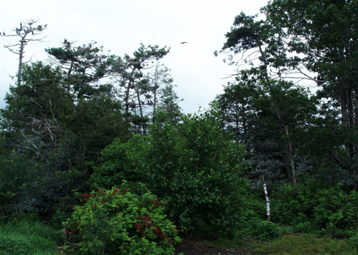
Long description for figure 3
Photograph of shrubs and trees on the eastern shore of Eleanor Island National Wildlife Area in 2009. A few Double-crested Cormorants are resting in high branches of a dead tree, and a gull is flying over the trees.
2.2 Wildlife Species
2.2.1 Birds
Despite its small size, a significant number of colonial waterbirds nest on Eleanor Island. The waterbird colony on Eleanor Island is considered to be very important within the region, and may even be the sole source of some of the regional populations it supports. The island supports one of the few Herring Gull (Larus argentatus), Double-crested Cormorant, and Great Blue Heron colonies in the vicinity of Lake Muskoka. The island provides refuge from predators for the young nestlings and easy access to prey in nearby waters.
In 1970 the island was reported to have 20-30 nesting pairs of Great Blue Herons and approximately 300 pairs of nesting gulls (mainly Ring-billed Gulls [Larus delawarensis] with some Herring Gulls). During a visit to the island in the spring of 1983, 23 Great Blue Heron nests were observed. At that time only five herons were on nests, but another 25 birds were flying above the island. Most of the heron nests were located in dead White Pine snags; 5 of the 13 live White Pines contained nests, while 9 of 10 dead pines contained nests. A few heron nests were also located in Red Oak trees.
Approximately 1200 Herring Gulls were on or around Eleanor Island during the above-noted 1983 visit. Herring Gull nests were scattered over the island. All areas except the cobble beach, the grass/raspberry cane area and dense shrubs supported gull nests; however, most nests were located in the more open, rocky western third. Of the nests that were found, 55 contained 1-3 eggs, and 92 recently constructed nests contained no eggs. It is safe to conclude that over 200 pairs of Herring Gulls nested on Eleanor Island NWA in 1983, with the total likely being much higher than 200 pairs (Weseloh, personal communication, 2010).
Double-crested Cormorants have had a nesting colony on Eleanor Island NWA since the early 1980s. They were first reported around Eleanor Island NWA by the Muskoka Field Naturalists: four birds were observed in May of 1982, and a pair was observed on the island in June of 1984.
In 2009, 238 Double-crested Cormorant nests and 30 Great Blue Heron nests were found in the trees, while 266 Herring Gull nests were located on the ground (CWS, 2010). Ring-billed Gulls appeared to have abandoned the site at some point between 1983 and 2009. The appearance of cormorants nesting in the trees does not appear to have negatively affected the number of nesting herons, and it is unlikely that cormorants would have caused the Ring-billed Gulls to leave the island (Weseloh, personal communication, 2010).
Eleanor Island NWA and its nearshore waters are considered to be low-habitat-use areas for staging and breeding waterfowl (OEHJV, 2007).
Numerous bird species pass through the Muskoka and neighbouring Algonquin regions during spring and fall migration along the Atlantic flyway. However, biological studies on Eleanor Island NWA have been focused on colonial nesting birds. The use and significance of the island for migratory and stopover habitat for other birds is unknown, and is not anticipated to be significant.
2.2.2 Other wildlife
Data on other wildlife has not been collected. However, in the summer of 2009 an Eastern Chipmunk (Tamias striatus) was observed (CWS, 2009).
2.3 Species at Risk
No species at risk have been recorded on Eleanor Island NWA.
3. Management challenges and threats
3.1 Ontario-wide threats to colonial waterbirds and habitat
Colonial waterbird populations in Ontario have been significantly affected by various challenges and threats, including non-native invasive aquatic species, botulism, disease, non-point-source pollution, toxics, incompatible development, and human disturbance from recreational activities. The degree to which colonial waterbird populations on Eleanor Island NWA and other islands in Lake Muskoka may be affected is largely unknown since long-term biological studies have not been carried out on these issues.
3.2 Unauthorized access and tourism
During the nesting season (March 15 - July 31), much of the island is occupied by colonial nesting waterbirds. Wave action and noise from boats and jet skis, and human presence in the nearshore (1.5 km from shore), are a significant concern during this period. Such disturbance may cause adult birds to flush off their nest, or in some cases abandon nests, eggs and young, increasing vulnerability to predation. Prolonged authorized visits to the island during nesting season are also likely to disturb the birds. The incidence of unauthorized access is unknown and the resources to monitor the site are limited.
Local tourism promotional materials reflect a general lack of understanding about the Canada Wildlife Act, Wildlife Area Regulations, and prohibited access and activities for Eleanor Island NWA: visits to Eleanor Island NWA and opportunities to view colonial nesting birds are among the materials’ listed attractions. As visitors to Lake Muskoka and the local area are largely seasonal and originate from a large geographic area, it is difficult to tailor and deliver compliance promotion materials to various audiences.
Since the NWA was established, population growth in nearby urban centres and public recreation in Lake Muskoka have both increased considerably. As the population of the Greater Toronto Area and southern Ontario continue to grow, tourism and associated boat traffic are expected to increase.
3.3 Eleanor Island NWA and MBS Protected Area Designations
Eleanor Island is designated as both an NWA and MBS. The original designation as an MBS (1971) to protect colonial nesting waterbirds was augmented by designation as an NWA (1978). Currently, signage on the site reflects the dual designation and may cause confusion for the general public regarding prohibited activities and public access.
3.4 Physical setting
Since there are no full-time CWS officials located on or near this site, compliance promotion, prevention of prohibited activities, and enforcement of regulations can be difficult.
3.5 Projected Climate Change and Variability
Climate change and continued variability is expected to be a significant factor affecting the Great Lakes basin including Lake Muskoka (Intergovernmental Panel on Climate Change (IPCC), 2007; Mortsch et al., 2006). Many of the current climate models indicate that climate change and variability may contribute to even lower water levels, warmer air temperatures due to a decrease in winter ice cover, subsequent increased evaporation, increased frequency and periods of high precipitation and extended drought, and changes in the timing of the annual hydrograph in each of the Great Lakes (IPCC, 2007; Mortsch et al., 2006). Some climate models suggest that if there is increased precipitation in the Great Lakes Basin, declines in water levels may be small, or even small increases may occur (Angel and Kunkel, 2010).
For Eleanor Island NWA, the possible implications of lower water levels in Lake Muskoka are twofold: an increase in the extent of the island, and vegetation changes. Although the island may enlarge, it is expected to remain isolated from the mainland due to the deep waters surrounding it, and continue to provide safe nesting habitat for colonial waterbirds. That being said, possible changes in vegetation may lead to different species of birds using the island and different management needs arising (For example, ground nesters, such as the Herring Gull may be affected if vegetation were to become too dense).
Although the impacts of climate change and variability on colonial waterbird populations are unknown, it is expected there will be shifts in species range, distribution and breeding behaviour. Opportunities to mitigate or adapt to impacts of climate change are limited by the small size and physical setting of the island. However, having an undeveloped island is of benefit to wildlife.
| Management challenges and threats | Goals and objectives | Management approaches (actions, including level of priority)a |
|---|---|---|
|
Goal 1: Conserve habitat of Eleanor Island NWA for wildlife. 1.1 Sub-Goal: Maintain populations of and habitat for colonial nesting waterbirds and seasonal migrants. Objectives:
|
|
|
Goal 2: Control prohibited activities in the NWA. 2.1 Sub-Goal: Prevent occurrences of prohibited activities and promote compliance with the Canada Wildlife Act and Migratory Birds Convention Act, 1994, and encourage timely reporting of hazardous conditions and occurrences. Objectives:
|
|
|
Goal 3: Promote health and safety. 3.1 Sub-Goal: Reduce and mitigate health and safety risks and hazards associated with authorized visits. Objectives:
|
|
a Level of Priority: 1 (from 0 to 3 years); 2 (from 4 to 6 years); 3 (from 7 to 10 years).
4. Goals and objectives
4.1 Vision
The long-term vision for Eleanor Island NWA is conservation: to maintain and enhance habitat for native wildlife, with priority being given to colonial nesting waterbirds.
4.2 Goals and objectives
The primary management goal for Eleanor Island NWA is to ensure that the colonial nesting waterbirds are protected from outside disturbances, in order to promote the long-term persistence of these colonies. To ensure that this goal is attained, specific goals and objectives have been identified. However, Eleanor Island NWA is a small, remote site where active management is not required. Management activities are limited to immediate needs and planned visits. Hence, the goals and objectives listed below reflect a passive “hands-off” management approach. The monitoring and survey approaches in section 5.1 provide additional information on how the overall goals are addressed.
Goal 1: Conserve habitat of Eleanor Island NWA for wildlife.
1.1 Sub-Goal: Maintain populations of and habitat for colonial nesting waterbirds and seasonal migrants.
- Objective: Natural processes are allowed to occur with minimal intervention, subject to monitoring, survey or research results.
- Objective: Habitat will only be managed (For example, invasive species removal, etc.) to maintain existing habitat quantity and quality for colonial nesting waterbirds and/or seasonal migrants, as determined to be necessary by monitoring, survey or research results.
Goal 2: Control prohibited activities in the NWA.
2.1 Sub-Goal: Prevent occurrences of prohibited activities and promote compliance with the Canada Wildlife Act and Migratory Birds Convention Act, 1994, and encourage timely reporting of hazardous conditions and occurrences.
- Objective: Authorized visitors and public understand and adhere to the prohibitions and reporting requirements of the Wildlife Area Regulations.
- Objective: Incidents and prohibited activities at Eleanor Island NWA are reduced or eliminated.
Goal 3: Promote health and safety.
3.1 Sub-Goal: Reduce and mitigate health and safety risks and hazards associated with authorized visits.
- Objective: Risks have been assessed and measures implemented to ensure the safety of authorized visitors.
- Objective: The status of existing permits and collaborative arrangements has been reviewed and renewed as appropriate.
- Objective: Target audiences and collaborators are aware of health and safety risks to authorized visitors (For example, through signage, notices and outreach materials).
4.3 Evaluation
Site visits to Eleanor Island NWA will be performed within the limits imposed by financial and human resources. The management plan will be reviewed in five years, and every ten years thereafter. Evaluation will comprise a review of monitoring, survey and research data obtained from the projects outlined below. This data and the review will be used to inform future management and evaluate federal contributions toward accomplishing the Environment Canada mandates for which the protected area was established. Significant new information may be appended to the management plan as required, to aid in site management and decision making.
5. Management approaches
This section describes approaches that could be used in the management of Eleanor Island NWA. However, management actions will be determined during the annual work planning process, and will be implemented as human and financial resources allow.
The overall management philosophy for Eleanor Island NWA will be to protect and preserve the nesting habitat of colonial waterbirds through a passive “hands off” approach.
5.1 Habitat Protection and Management
There has been no active habitat or vegetation management within the NWA. Instead, natural processes have been allowed to occur unimpeded. In general, natural processes will be allowed to continue at Eleanor Island NWA, unless regular site visits or research determine that habitat management is necessary to maintain habitat quality or quantity for nesting or migratory birds.
Habitat studies to assess vegetation, aerial extent of the island, bird use and habitat change, will be conducted periodically in order to evaluate management practices, identify potential threats and stressors, and identify opportunities for mitigation.
5.2 Wildlife Management
There has been no active wildlife management of this NWA. Protection and conservation of nesting habitat for colonial nesting waterbirds will be achieved primarily through restricting human visitation to the site. In accordance with the Canada Wildlife Act, all wildlife species are protected within the NWA. Management of Double-crested Cormorants may be considered if it is determined that their increasing population is impacting the Great Blue Heron population.
Colonial nesting waterbirds will be surveyed and threats will be assessed. However, certain threats to the birds (For example, changes in food resources, weather events, toxics, disease and bird mortality) are considered to be beyond the influence of localized management approaches.
5.2.1 Species at Risk
There are presently no species at risk identified on Eleanor Island NWA.
5.3 Monitoring
Monitoring and survey projects at Eleanor Island will continue to occur, within the limits of financial and human resources as noted above.
Occasional surveying of colonial nesting and migrant bird populations at Eleanor Island NWA will occur in order to contribute to the knowledge of birds and their habitat, and to respond to emerging issues. Should significant declines in colonial nesting waterbird numbers be observed, causes may be investigated and appropriate mitigation may be undertaken.
- Occasional survey or census of colonial nesting waterbird species on the island.
- Assessment of the overall environmental quality of the area with an emphasis on habitat quality for colonial waterbirds and their nesting sites.
- Assessment of the impact of management practices or nearby public activities on the ecological integrity of the NWA.
This data will be shared with departmental officials, and incorporated as appropriate into efforts to answer larger questions about the health of the various species over their ranges (For example, North American Bird Conservation Initiative, Bird Conservation Region planning, waterbird conservation, Great Lakes Basin toxics monitoring, island conservation, etc.).
Periodic visits by wildlife enforcement officials will also occur, particularly during colonial waterbird nesting periods, and enforcement actions will be taken when required or as prioritized in enforcement plans of Environment Canada’s Wildlife Enforcement Directorate.
Site visits and maintenance activities, including ongoing reporting of site conditions, occurrences of prohibited activities and vandalism as well as installation or replacement of NWA signage, will be employed to monitor the island.
Signage will be reviewed and updated periodically to ensure that it provides clear direction to discourage unauthorized landings on the island. All signs, public information and notices will include contact information to report incidents of prohibited activities observed by authorized visitors or passing boaters.
5.4 Research
Colonial waterbirds on Eleanor Island NWA have been studied by CWS Ontario, the Ontario Ministry of Natural Resources, and the Muskoka Field Naturalists.
- improved understanding of colonial nesting waterbirds;
- vegetation inventory and monitoring of change over time; or
- seasonal habitat use (including nearshore) by waterbirds, waterfowl, shorebirds, and landbirds.
Permits are required to conduct research, survey and monitoring projects at the Eleanor Island NWA. All research requests must be made in writing to CWS Ontario. To request a Canada Wildlife Act (CWA) permit to conduct research, or to obtain information, please contact the CWS as follows:
Environment Canada
Canadian Wildlife Service
Ontario Region
867 Lakeshore Road
Burlington ON L7R 4A6
Tel.: 905-336-4464
Fax: 905-336-4587
Email: Wildlife Ontario
The CWS may impose conditions on the permit or require changes to the research design in order to standardize techniques, mitigate impacts, or meet protocols and animal care guidelines. Conditions may require that specific measures or restrictions be followed in order for the study to proceed. Issuance of a CWA permit may be denied if the CWS determines that the conditions as described in Appendix 1 are not met.
5.5 Public information and awareness
Public involvement and outreach activities are designed to enhance public understanding and appreciation of the important conservation role of Eleanor Island NWA for colonial water birds, and to encourage public cooperation in wildlife conservation.
As public access is prohibited at Eleanor Island NWA, on-site awareness programs are not planned. General information on NWAs and Eleanor Island NWA are posted on the CWS website (Protected Areas).
6. Authorizations and prohibitions
To protect and conserve wildlife and their habitats, human activities are minimized and controlled in NWAs through the implementation of the Canada Wildlife Act and Wildlife Area Regulations. These regulations set out activities that are prohibited (subsection 3(1)) in the wildlife area and provide mechanisms to the Minister of the Environment to authorize certain activities to take place in NWAs that are otherwise considered prohibited. The regulations also provide the authority for the Minister to prohibit entry into NWAs.
All activities in an NWA are prohibited unless a notice has been posted or published authorizing the activity to take place. Activities within an NWA are authorized where notices or signs have been posted at the entrance to or along the boundaries of the NWA, or when notices have been published in local newspapers. However, in addition to notices, certain activities may be authorized by obtaining a permit from the Minister of the Environment.
Public access to Eleanor Island NWA is prohibited.
6.1 Prohibition of entry
Under the Wildlife Area Regulations, the Minister may post notices at the entrance of any wildlife area, or on the boundary of any part thereof, prohibiting entry to any wildlife area or part thereof. These notices can be posted when the Minister is of the opinion that entry is a public health and safety concern and when entry may disturb wildlife and their habitat.
Public entry to Eleanor Island NWA is prohibited, except by Canada Wildlife Act permit for purposes of research, survey and monitoring, to ensure that human activities do not interfere with colonial waterbird nesting and associated habitats. The notices of prohibited entry are posted on five NWA signs around the perimeter of the island.
General prohibitions applicable to all NWAs apply to Eleanor Island NWA, unless notices to the contrary have appeared in local newspapers or have been posted at the site, or by authorized permit. Prohibitions can be found in the Canada Wildlife Act and Wildlife Area Regulations.
Note: If there is a discrepancy between the information presented in this document and the notice, the notice prevails, as it is the legal instrument prohibiting entry.
6.2 Authorizations
Permits and Notices authorizing an activity may be issued only if the Minister is of the opinion that the activity is scientific research relating to wildlife or habitat conservation, or the activity benefits wildlife and their habitats or will contribute to wildlife conservation, or the activity is not inconsistent with the purpose for which the NWA was established and is consistent with the most recent management plan.
The Minister may also add terms and conditions to permits in order to minimize the impact of an activity on wildlife and wildlife habitat.
All requests for permits or authorizations must be made in writing to the following address:
Environment CanadaCanadian Wildlife Service
Ontario Region
867 Lakeshore Road
Burlington ON L7R 4A6
Tel.: 905-336-4464
Fax: 905-336-4587
Email: Wildlife Ontario
For further information, please consult the Policy when Considering Permitting or Authorizing Prohibited Activities in Protected Areas Designated Under the Canada Wildlife Act and Migratory Bird Convention Act, 1994 (December 2011). This Environment Canada policy document is available on the Protected Areas website.
6.3 Authorized activities
There is no authorized public access to Eleanor Island NWA, except by Canada Wildlife Act permit for research, survey and monitoring purposes.
Recreational boating in the nearshore, and bird watching from offshore, are not restricted. However, boats are prohibited from landing on the NWA.
Note: If there is a discrepancy between the information presented in this document and the notice, the notice prevails, as it is the legal instrument authorizing the activity.
6.4 Other federal and provincial authorizations
Although access to the Eleanor Island NWA is prohibited (unless authorized by federal permit as noted above), some activities (such as hunting and fishing) may be undertaken in areas adjacent to the NWA. Federal or provincial permits may be required to undertake such activities in the waters adjacent to Eleanor Island NWA.
Provincial and Federal permits and “seasons” apply for hunting and fishing adjacent to NWA. Contact regional federal and provincial permitting office for more information.
Environment CanadaCanadian Wildlife Service
Ontario Region
867 Lakeshore Road
Burlington ON L7R 4A6
Tel.: 905-336-4464
Fax: 905-336-4587
Email: Wildlife Ontario Ontario Ministry of Natural Resources
300 Water Street, P.O. Box 7000
Peterborough ON K9J 8M5
Tel.: 1-800-667-1940
6.5 Exceptions
The Wildlife Area Regulations allow for exceptions to the prohibited activities under the following circumstances:
- Activities related to public safety, health or national security, that are authorized by or under another Act of Parliament, or activities under Health of Animals Act and Plant Protection Act that are intended to protect the health of animals and plants
- Activities related to routine maintenance of NWAs, implementation of management plans, and enforcement activities conducted by an officer or employee of Environment Canada.
For Eleanor Island NWA, exceptions to the prohibited activities include, but are not limited to, research, survey and monitoring of colonial waterbirds. These activities must be administered through permits and formal collaborative arrangements.
Requests to the CWS for Canada Wildlife Act permits must be made in writing at least seven weeks prior to the commencement of proposed activities. Canada Wildlife Act permit requests will be denied if in the opinion of the management authority the proposed activity is not in the best interest of the protected area.
Authorized visits to Eleanor Island NWA are to be coordinated through CWS Ontario’s Protected Areas and Stewardship Unit, to avoid accidental interference of projects, duplication of effort, or excessive disturbance to colonial and migratory birds.
Authorized visitors to the area should exercise caution, as navigation to Eleanor Island NWA can be dangerous. The island is located in an open area of Lake Muskoka that is deep, has a long fetch, and is subject to high westerly winds.
7. Health and safety
Authorized visitors to Eleanor Island NWA often contend with high wind, inclement weather, deep water, rocky shorelines, and shoals. Authorized visitors to the area and NWA must seek and heed expertise to operate in these environments, and must demonstrate they have required training and certification or means to access the site safely.
All reasonable efforts will be made to protect the health and safety of the public, including adequately informing authorized visitors of any known or anticipated hazards or risks. Furthermore, Environment Canada officials will take all reasonable and necessary precautions to assure their own health and safety and that of their co-workers. However, authorized visitors must make all reasonable efforts to inform themselves of risks and hazards and must be prepared and self-sufficient. Natural areas are inherently dangerous and proper precautions must be taken by authorized visitors, recognizing that Environment Canada officials neither regularly patrol nor offer services for visitor safety in NWAs.
Management activities directed at improving health and safety and reducing the risk of a hazardous occurrence may include the following:
- Installation of and replacement of signs identifying safety precautions for authorized visitors.
- Posting of public notices at local boat launches and tourist operations.
- Communications with local tourism bodies, neighbouring landowners, and stakeholders, to indicate that entry prohibited.
Site visits by CWS officials will be conducted regularly to monitor signs and site conditions. Periodic, formal site assessments may be performed by federal agencies.
7.1 Emergency contact information
In the case of an emergency at the NWA, call 911 immediately.
In the event of an environmental emergency or occurrence, please call the 24-hour telephone number below:
Ontario Spills Action Centre
Ontario Ministry of the Environment
Telephone: 416-325-3000 or 1-800-268-6060
Any emergency should be reported immediately to the appropriate responding authorities. Reports should include the date, time and nature of the incident, contact names and information of the reporting party, and other relevant details. Multiple authorities should be advised, if the situation warrants, as soon as possible. Refer to Appendix 2 for a list of contacts.
Non-emergency issues related to security or health and safety issues for Eleanor Island NWA should be reported to:
Environment CanadaCanadian Wildlife Service
Ontario Region
4905 Dufferin Street
Toronto ON M3H 5T4
Tel.: 416-514-2633
8. Enforcement
To promote compliance with the Canada Wildlife Act and Wildlife Area Regulations, the CWS posts signs along the NWA boundaries and at main access points, which identify what activities are authorized within each NWA and any conditions imposed on those activities.
Environment Canada’s Wildlife Enforcement Directorate is responsible for enforcement of federal and provincial wildlife laws. Directorate officers perform on-site inspections and investigations, and patrol the NWA to promote compliance and prevent prohibited uses within the NWA. When necessary, charges will be laid.
The management of NWAs is based on three acts and the regulations thereunder:
- Migratory Birds Convention Act, 1994, and Migratory Birds Regulations
- Canada Wildlife Act and Wildlife Area Regulations
- Species at Risk Act
Officers monitor compliance with the acts and regulations on an ongoing basis and will initiate investigations when required. Officials with CWS Ontario’s Protected Areas and Stewardship Unit provide Enforcement Branch officials with details from site inspections that may require enforcement action.
9. Plan implementation
The management plan will be implemented over a 10-year period. Annual work plans will be developed in accordance with priorities and budgets and the details of management plan implementation will be developed through Environment Canada’s annual work planning process and will be implemented as human and financial resources allow. The implementation of the plan will be evaluated five years after its publication, on the basis of the actions identified in Table 4.
The major action component of this plan consists of monitoring and review. Site inspections and bird census data will provide information to identify additional necessary management actions (For example, signage, outreach), and to identify potential threats to wildlife and birds as well as the health of the colonial nesting birds.
Frequency of sites visits is based on limits of financial and human resources. Attempts will be made to coordinate among sections and branches to ensure maximum efficiencies when Environment Canada officials are visiting the site.
| Activity | 2013 | 2014 | 2015 | 2016 | 2017 | 2018 | 2019 | 2020 | 2021 | 2022 |
|---|---|---|---|---|---|---|---|---|---|---|
Site Inspection:
|
x | x | x | x | x | x | x | x | x | x |
| Maintain NWA designation and formally delist Eleanor Island as an MBS | - | - | - | x | x | x | - | - | - | - |
| Review permits and collaborative arrangements; revise and renew as appropriate | x | x | x | x | x | x | x | x | x | x |
9.1 Management authority and mandate
CWS Ontario is responsible for site management of Eleanor Island NWA.
9.2 Management Plan review
This management plan will be reviewed and updated five years after formal approval by Environment Canada, and every ten years thereafter. Significant new information may be appended to the document as required, to aid in site management and decision making.
10. Collaborators
In order to meet goals for on-site survey and monitoring, address legislative or policy requirements, and contribute to landscape conservation in order to ensure ongoing protection for nationally important spaces, CWS Ontario works with other departmental branches, other federal agencies, provincial, municipal and regional governments, Aboriginal peoples, non-governmental organizations, and individuals.
There are no formal collaborative arrangements for management of Eleanor Island NWA. Informal collaborative arrangements have been established with Environment Canada’s Wildlife and Landscape Science Directorate (Science and Technology Branch), the Ontario Ministry of Natural Resources, and the Township of Muskoka Lakes, to monitor and share information and data on colonial waterbirds.
11. Literature cited
Angel, J. R. and K. E. Kunkel. 2010. The response of Great Lakes water levels to future climate scenarios with an emphasis on Lake Michigan. J. Great Lakes Res. 36: 51-58.
CWS (Canadian Wildlife Service). 2010. Colonial waterbird census at Eleanor Island National Wildlife Area 1983. Unpublished data. Burlington, Ontario.
CWS (Canadian Wildlife Service). 2009. Eleanor Island National Wildlife Area site visit. July 2, 2009. Unpublished data. London, Ontario.
CWS (Canadian Wildlife Service). 1983. Colonial waterbird census at Eleanor Island National Wildlife Area 1983. Unpublished data. Burlington, Ontario.
Dudley, N. (editor). 2008. Guidelines for Applying Protected Area Management Categories. IUCN, Gland, Switzerland. x + 86 pages.
Environment Canada. 1991. The Importance of Wildlife to Canadians. (Accessed September 2, 2010.)
IPCC (Intergovernmental Panel on Climate Change). 2007. IPCC Fourth Assessment Report: Climate Change 2007.
McCullough, G. B. and J. T. Planck, 1985. Management Plan: Eleanor Island National Wildlife Area. Canadian Wildlife Service, London, Ontario.
Mortsch, L., E. Snell and J. Ingram. 2006. “Chapter 2. Climate variability and changes within the context of the Great Lakes basin.” In L. Mortsch, J. Ingram, A. Hebb, and S. Doka (editors). Great Lakes Coastal Wetland Communities: Vulnerability to Climate Change and Response to Adaptation Strategies. Environment Canada and the Department of Fisheries and Oceans, Toronto, Ontario. page 9-19.
OEHJV (Ontario Eastern Habitat Joint Venture). 2007. Ontario Eastern Habitat Joint Venture Five-Year Implementation Plan 2006-2010. 94 pages.
Weseloh, D. V. August 2010. Environment Canada, Canadian Wildlife Service (Ontario). Personal communication.
Appendix I: Canadian Wildlife Service (Ontario) Conditions of Research Requests in National Wildlife Areas
Permission under the Wildlife Area Regulations of the Canada Wildlife Act to undertake research may be given subject to the following conditions:
- All requests for research must be accompanied by a written proposal outlining the objectives, project duration, collection of data and specimens and measurements if any, number of participants, funding sources, location where work is to be undertaken, benefits to the NWA, potential detractors, and proposed mitigation measures. All proposals will be subject to a review by the Animal Care Committee of Environment Canada or the submitting institution.
- No research shall be undertaken without a permit issued under the Canada Wildlife Act’s Wildlife Area Regulations, and the research must be consistent with the National Wildlife Area (NWA) management plan for the site and relevant legislation (For example, Species at Risk Act or Migratory Birds Convention Act, 1994).
- All researchers must conform to regulations in effect regarding the NWA.
- All researchers are responsible for obtaining all permits (For example, Species at Risk Act, Fisheries Act), approvals, and permissions (For example, land managers, landowners), prior to commencement of the research project.
- Copies of raw data (field books and maps), preliminary reports of the research activities, and a copy of the final manuscript must be provided to Environment Canada, Canadian Wildlife Service (CWS) Ontario at the end of each field season.
- Priority will be given to researchers whose work has direct management implications for the NWA and species at risk.
- Applications to undertake a minor research study must be submitted to the CWS Ontario office, in writing, prior to commencement of the project. Minor proposals without problems or issues require at least seven weeks for review, processing and issuance of a permit. Major proposals (that may require expert review, are multi-year, etc.) require a longer review period (minimum six months).
- A statement must be provided to CWS Ontario on why the research project cannot be undertaken elsewhere.
- Any proposed work is subject to the Canada Labour Code, Part II (subject to the strictest safety certification, training, operational experience and mandatory use of appropriate safety equipment).
Note: The Minister may add terms and conditions governing the activity in order to protect and minimize the effects of the authorized activity on wildlife and their habitats. All projects and activities in the NWA are subject to environmental screening and, if necessary, to further steps in the Environmental Assessment and Review Process of Environment Canada.
Appendix II: Contacts for Eleanor Island National Wildlife Area
| Emergency contacts | No. |
|---|---|
| In case of emergency, dial 911. General inquiries should be directed to local telephone numbers, not 911. Note: there is no civic address for Eleanor Island NWA The closest boat launch to Eleanor Island on the mainland is at St. Elmo’s Wharf, Regional Road 16 / Beaumont Drive |
- |
| Any life-threatening emergency | 911 |
| Police-Fire-Ambulance | 911 |
| Ontario Provincial Police | 1-888-310-1122 Nearest detachment: Bracebridge, 705-645-2211 |
| To report air and marine emergencies, contact Ontario Provincial Police | 911 1-888-310-1122 |
| Marine radio channel: distress, safety, calling, monitored for emergencies | VHF 16 & 65 are ONLY for emergency and calling - all regions |
| Royal Canadian Mounted Police (RCMP), Ontario Division | 519-640-7267 |
| To report a spill to air, land or water, call the Ontario Spills Action Centre, 24/7 | 1-800-268-6060 or 416-325-3000 |
| Poison Control Centres (Emergencies) | 1-800-268-9017 |
| Nearest hospital - South Muskoka Memorial Hospital 75 Ann Street, Bracebridge, Ontario | 705-645-4400 |
| Environment Canada - Ontario | - |
| Canadian Wildlife Service (Ontario) | 1-800-668-6767 |
| Wildlife Enforcement Directorate ( Ontario) | 905-336-6410 |
| General Contacts | - |
| Ontario Ministry of Natural Resources (Conservation Officer) | 1-877-847-7667 |
| Ontario Ministry of Natural Resources (General Inquiry) | 1-800-667-1940 |
| Ontario Ministry of Natural Resources area office Bracebridge | 705-645-8747 |
| Town of Bracebridge, Township of Muskoka Lakes (formerly District Municipality of Muskoka) | 705-645-5264 |
| Corporation of the Town of Gravenhurst | 705-687-3412 |
| Environment Canada Weather Forecast | Region: Ontario Location: Gravenhurst |