
St. Denis National Wildlife Area management plan
Long description for the cover page
Male Mallard resting on a dead tree in waters.
National Wildlife Area boundary sign in a grass area.
Wetland at St-Denis National Wildlife Area.
Table of contents
- Document information
- About Environment Canada Protected Areas & Management Plans
- St. Denis National Wildlife Area
- 1. Site description
- 2. Ecological resources
- 3. Management challenges & threats
- 4. Goals & objectives
- 5. Management approaches
- 6. Prohibited activities and entry
- 7. Health & safety
- 8. Enforcement
- 9. Plan implementation
- 10. Collaborators
- 11. Literature cited
- Appendix 1. St. Denis NWA research publications (to 2010)
- Appendix 2. St. Denis NWA agricultural activities (1968-2010)
List of figures
- Figure 1. St. Denis National Wildlife Area.
- Figure 2. Oblique aerial view of St. Denis National Wildlife Area in August 2007, and the arrangement of pothole wetlands and remnant natural habitats within a matrix of agricultural land.
- Figure 3. Map of major upland and lowland habitats on St. Denis National Wildlife Area.
- Figure 4. Map of seasonal and semi-permanent ponds, overflow channels and major drainage divides within the boundaries of St. Denis National Wildlife Area. The map is in meters.
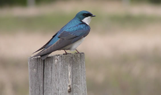
- Figure 5. Tree swallow,Tachycineta bicolor, emerging from an artificial nest box erected on St. Denis National Wildlife Area.
- Figure 6. Map of proposed planted cover types to restore or enhance wildlife habitats at St. Denis National Wildlife Area.
- Figure 7. Map of proposed fences (white dash-dot lines) and management regimes for prescribed burning and livestock grazing at St. Denis National Wildlife Area after revegetation is completed in 2016.
- Figure 8. Map of proposed trail network, gates, and low crossings at St. Denis National Wildlife Area to be implemented by 2016.
List of tables
- Table 1. Protected Area Summary
- Table 2. Facilities & Infrastructure
- Table 3. Management Challenges & Threats
- Table 4. Desired seed mixes for native grassland and dense nesting cover to be planted at St. Denis National Wildlife Area 2012-2016.
- Table 5. Pasture descriptions and grazing regimes proposed for St. Denis National Wildlife Area after revegetation is completed in 2016.
- Agricultural Activities (1968-2010)
Document information
Acknowledgements:
Contributions through reviews and consultations were made by Angela Bedard-Haughn of the University of Saskatchewan (UofS), Ron Bennett from Environment Canada’s Canadian Wildlife Service (EC-CWS), Ken Born (EC-CWS), Robert Clark (EC-Science &Technologies), Malcolm Conly (EC-Science &Technologies), Jane Elliott (EC- Science &Technologies), Susanne Emond (EC-CWS), Normand Fontaine (agricultural lessee), Nancy Glozier (EC-Science &Technologies), Britt Hall (University of Regina), Kerry Hecker (EC-CWS), Olaf Jensen (EC-CWS), Steve Leach (EC- Science &Technologies), Richard McBride (Ducks Unlimited Canada), Emily McIvor (EC- Science &Technologies), Dan Pennock (UofS), Randy Schmidt (EC- Science &Technologies), Bing Si (UofS), Chris Spence (EC- Science &Technologies), Phil Taylor (EC-CWS retired), Garth van der Kamp (EC- Science &Technologies), Marley Waiser (EC- Science &Technologies), Cherie Westbrook (UofS), Eric Woodsworth (EC-CWS), and Stan Woynarski (EC-CWS retired).
Copies of this Plan are available from:
Environment CanadaInquiry Centre
10 Wellington, 23rd Floor
Gatineau QC K1A 0H3
Toll Free: 1-800-668-6767 (in Canada only)
Email: enviroinfo@ec.gc.ca Environment Canada - Canadian Wildlife Service
115 Perimeter Road
Saskatoon SK S7N 0X4
Website for Environment Canada Protected Areas.
Cover photos:
© Environment Canada - Canadian Wildlife Service (left - Mallard duck, photo: G. Bechdolff; middle - boundary sign; right - prairie pothole wetland, photo: Darcy Henderson)
Prepared by:
Darcy Henderson
Information contained in this publication or product may be reproduced, in part or in whole, and by any means, for personal or public non-commercial purposes, without charge or further permission, unless otherwise specified.
You are asked to:
- Exercise due diligence in ensuring the accuracy of the materials reproduced;
- Indicate both the complete title of the materials reproduced, as well as the author organization; and
- Indicate that the reproduction is a copy of an official work that is published by the Government of Canada and that the reproduction has not been produced in affiliation with or with the endorsement of the Government of Canada.
Commercial reproduction and distribution is prohibited except with written permission from the author. For more information, please contact Environment Canada’s Inquiry Centre at 1-800-668-6767 (in Canada only) or 819-997-2800 or email to enviroinfo@ec.gc.ca.
Aussi disponible en français
About Environment Canada protected areas & management plans
What are Environment Canada Protected Areas?
Environment Canada establishes marine and terrestrial National Wildlife Areas, and Migratory Bird Sanctuaries for the purposes of conservation, research, and interpretation. These areas are established to protect migratory birds, species at risk, and other wildlife and their habitat. National Wildlife Areas are established under the authority of the Canada Wildlife Act and are, first and foremost, places for wildlife.
What is the size of the Environment Canada protected areas network?
The current Protected Areas Network consists of 54 National Wildlife Areas and 92 Migratory Bird Sanctuaries comprising more than twelve million hectares across Canada.
What is a management plan?
Management plans provide the framework in which management decisions are made. Management plans are intended to be used by Environment Canada staff to guide decision making, especially with respect to permitting. Management is undertaken in order to maintain the ecological integrity of the protected area and to maintain the attributes for which the protected area was designated. Canadian Wildlife Service (CWS) prepares a management plan for each protected area in consultation with the public and other stakeholders.
The management plan specifies activities that are allowed and identifies other activities which may be undertaken under the authority of a permit. Management plans may also specify how and where to make habitat improvements. Management plans must respect Aboriginal rights and allowable practices specified under land claims agreements. Further, measures carried out for the conservation of wildlife must be consistent with any law respecting wildlife in the province in which the lands are situated.
What is protected area management?
Management includes monitoring wildlife, maintaining and improving wildlife habitat, periodic inspections of facilities, enforcement of regulations, and the maintenance of signs and other infrastructure. Research is also an important function of protected areas; hence, Environment Canada staff carries out or coordinates research at some sites.
Each protected area is managed in accordance with the specific characteristics of the site and of the local area but shares the same overall management strategy: to protect and maintain habitat vital for wildlife and to improve habitat when necessary for wildlife use.
The series
All National Wildlife Areas administered by Environment Canada will have a management plan. These management plans will initially be reviewed 5 years after the approval of the first plan, and every 10 years after.
To learn more
To learn more about Environment Canada’s protected areas, please visit our website or contact the Canadian Wildlife Service.
St. Denis National Wildlife Area
The St. Denis National Wildlife Area was established in 1968 to provide a location for Environment Canada scientists to research waterfowl habitat and wetland ecology. Canada’s Prairie Ecozone is one of the most important habitats for migratory waterfowl in North America, but it is also one of the most modified Ecozones in Canada. Of particular concern are "prairie potholes", a wetland type that is unique to formerly glaciated portions of the northern Great Plains. Prairie potholes are usually small, closed-basin ponds that provide ideal seasonal habitat for migratory ducks to pair-bond in spring and raise broods of ducklings in summer. Regionally, most of this habitat has been drastically altered by agriculture over the last 100 years, with many wetlands drained and most uplands plowed to produce annual crops. Thus, scientists working at St. Denis National Wildlife Area are mainly interested in how these land use changes have affected waterbird populations and associated wetland and upland habitats.
Habitats at St. Denis National Wildlife Area include patches of natural fescue prairie, aspen forests, and more than 200 wetland basins scattered amongst cultivated or formerly cultivated lands. Initially in 1968, 60% of the 383 hectares were agricultural lands under cultivation for annual crops. Over time, Environment Canada has gradually taken more land out of production and reseeded lands to perennial grasses, such that only 34% of the area is now cultivated for annual crops. Wetland habitats fluctuate with regional cycles of dry and wet weather, such that water can cover as little as 1% or as much as 22% of St. Denis National Wildlife Area in a given year. In the absence of fire, patches of trees and shrubs have expanded, but the combination of this expansion and the invasion of alien plants has gradually reduced the area of fescue prairie since 1968. Fescue prairie is a unique and increasingly rare natural habitat in Canada, now reduced by 95% into many small and isolated fragments.
Important scientific knowledge has been gained from work at St. Denis National Wildlife Area, resulting in the publication of more than 100 scientific journal articles, and more than 25 university student theses. Scientists greatly value the long-term monitoring of changes in weather, water levels, land use, and waterbird communities. Many new research projects make use of the archived longterm data, and contribute to on-going restoration and enhancement of waterfowl habitats on-site and throughout the region. Partners from Ducks Unlimited Canada and the University of Saskatchewan have been important contributors and collaborators in these research efforts. In future, St. Denis National Wildlife Area will continue to provide opportunities for research into waterfowl and wetland ecology, and the restoration or enhancement of degraded and rare habitats.
1. Site description
St. Denis National Wildlife Area (NWA) serves an important research function for Environment Canada - Canadian Wildlife Service (EC-CWS) (Table 1). Since research began there in 1968 nearly 100 refereed articles and more than 25 graduate student theses have been published from work conducted on site (Appendix 1). The key features that make St. Denis National Wildlife Area (NWA) important and special include:
- A high density and variety of wetlands and land cover types in a small, 383 ha, area (Figure 1) that makes possible detailed studies of variation in waterbird and wetland ecology, hydrology, and pedology.
- Consistent agricultural habitat management practices for decades.
- Consistent and long-term monitoring of wetland water depth (since 1968), waterbird community composition (since 1983), weather, groundwater depth, runoff, tree swallow productivity, and emergent aquatic invertebrate abundance (since 1990), and snow pack (since 1996).
- Proximity to research staff and laboratories of EC and the University of Saskatchewan (UofS) in Saskatoon (40 kilometres (km)).
- Security of the government-owned property to attract external investments in long-term research studies without risk of interruption due to land tenure or land use changes.
These features make St. Denis NWA very different from the surrounding landscape. Despite being a protected area under the Canada Wildlife Act, St. Denis NWA supports a higher density of human activity than all surrounding properties with similar land cover patterns. What began in 1968 as CWS studies focused on waterfowl responses to agricultural habitat, has expanded and diversified to include research on ecological goods and services, and environmental issues within the mandate of EC. Collaborations with universities from across Canada continue to grow, as does the demand for coordinating the increased research activity and on-going habitat management.
Most of the land at St. Denis NWA was plowed and used for agricultural crop production in the past, but now provides an opportunity to restore or enhance the degraded and remaining good habitats. Since the creation of the site in 1968, and designation under the Wildlife Area Regulations in 1978, a number of new legislative and policy changes influence site management. Waterfowl were the original concern as a high-priority consumptive wildlife resource, but other groups of migratory birds, species at risk, and rare or unique habitats are now part of the criteria for selection and directing management on National Wildlife Areas. How these changes can be accommodated while sustaining continued research activity will be the focus of this management plan.
| Category | Information |
|---|---|
| Protected Area Designation | National Wildlife Area (NWA) |
| Province/territory | Saskatchewan |
| Latitude/longitude | 52°12’N, 106°5’W |
| Size (hectare (ha)) | 361.445 hectares (+22 ha wetland that is Provincial Crown) |
| Protected Areas (PA) designation criteria | Historically: Secure an agricultural habitat with a high density of wetlands to research waterfowl ecology in close proximity to a CWS research facility in Saskatoon. Currently: Criterion 1.c) Area possesses a high potential for wildlife research, for restoration of degraded habitats or enhancement of good habitats for the benefit of wildlife, particularly migratory birds; and Criterion 3. Area possesses rare rough fescue (Festuca hallii) habitats reduced to a remnant of their former extent. |
| PA Classification System | B -Site Connectivity |
| International Union for Conservation of Nature and Natural Resources (IUCN) Classification | IV - Habitat/Species Management Area |
| Order in Council Number | SOR/78-408. |
| DFRP number | 14426 |
| Gazetted | 1978 |
| Additional designations | None. |
| Faunistic and floristic importance | Mallard duck (Anas platyrynchos) is the flagship species for the North American Waterfowl Management Plan which funded much of the research at St. Denis since the mid-1980s. Plains rough fescue (Festuca hallii) herbaceous vegetation communities are regionally unique and rare, with a NatureServe Table Footnotea conservation status rank of Subnational or provincial (S1) in Alberta, Manitoba, and Montana. |
| Invasive species | Noxious weeds under the Saskatchewan Weed Control Act include: wild oat (Avena fatua), Canada thistle (Cirsium arvense), quack grass (Elymus repens), wild mustard (Sinapis arvensis), perennial sow thistle (Sonchus arvensis), dandelion (Taraxacum officinale), and stinkweed (Thlaspi arvense). Other alien invasive species of concern include: smooth brome (Bromus inermis), Canada bluegrass (Poa compressa), Kentucky bluegrass (Poa pratensis), red fescue (Festuca rubra), reed canary grass (Phalaris arundinaceae), yellow sweet-clover (Melilotus officinalis), white sweet-clover (Melilotus alba), alfalfa (Medicago sativa), and Siberian pea-shrub (Caragana arborescens). |
| Species at Risk | None recorded. |
| Management Agency | Environment Canada - Canadian Wildlife Service |
| Public Access & Use | Prohibited without a permit. |

Long description for Figure 1
Figure 1 is a location map of the St. Denis National Wildlife Area (NWA) in the province of Saskatchewan. The map shows the boundaries of the NWA (with a polygon) and its location relative to roads in the province. The NWA is located in the center of the province. The map is in meters.
1.1 Regional context
St. Denis NWA is a 383 ha rectangular land parcel within Canada’s Prairie Ecozone, near the boundary between the Moist Mixed Grassland and Aspen Parkland Ecoregions (Wiken 1986). The regional climate is cool and subhumid, with more precipitation falling as rain during the warm summer, and relatively less precipitation falling as snow during the cold winter. Climate normals for nearby Saskatoon indicate mean annual precipitation is approximately 350 millimetres (mm), while temperatures range from a mean July high of +25 °Celsius (C) and a mean January low of -22 °C (Environment Canada 2011).
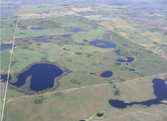
The landscape immediately surrounding and containing the St. Denis NWA is a hummocky moraine, known regionally as "knob and kettle" or "prairie pothole" terrain due to the high density of small, closed-basin wetlands contained in a matrix of grassland vegetation on the surrounding low hills (Figure 2). The wetlands vary in size, water permanence, and salinity (Millar 1976, Stewart & Kantrud 1971). Based on a Digital Elevation Model of the surrounding landscape, St. Denis NWA falls within a 24 square kilometres (m2) internal drainage watershed, with some seasonal overflow and groundwater connections among the wetlands. Some larger wetlands within the NWA receive most of their water from the surrounding watershed, and may thus be sensitive to land-use change beyond the NWA boundaries. Elevations within the watershed range from 540 to 602 metres (m) above sea level (asl), while in the NWA local relief varies from 540 to 575 m asl (Toyra and others (et al). 2008). The hummocky terrain also creates diversity in upland vegetation due to differences in slope aspect or slope position, with relatively moist North-facing toe slopes and relatively dry South-facing shoulder slopes (Baines 1964).
Agricultural land use and private land ownership dominate the region, leading to frequent changes in land cover and land use driven by changes in global demand and prices for commodities. As a result, many native species and natural processes that depend upon large and stable expanses of natural land cover (i.e., migratory bison herds or wild fire) are now missing from the ecosystem. Surrounding upland vegetation was naturally fescue prairie (Coupland and Brayshaw 1953), but most of that vegetation and underlying dark-brown chernozemic soil was plowed and converted to cropland over the last century. Many wetlands were also drained or filled to further increase the area of cropland (Millar 1976; Bartzen et al. 2010). The region is now fragmented by the grid road network that follows North-South and East-West road allowances every 1.6 to 3.2 km (McKercher and Wolfe 1997). This road network can interfere with wildlife and water movements, as well as facilitate movement of invasive alien species, pollutants, and native predators and parasites of wildlife (Forman et al. 2003). Surrounding agricultural activities include grain, protein, and oilseed annual crop production, perennial forage crop haying, and livestock grazing. Widespread use of pesticides and fertilizers, and erosion of cultivated soils, has affected local water and soil quality (Donald et al. 2007; Papiernik et al. 2005).
The result of these regional and landscape changes in land cover and land use is that most remaining wildlife tend to be adaptable or generalist species. Although the surrounding landscape supports species at risk such as the piping plover (Charadrius melodus), there is a larger number of species from the extirpated or extinct categories including plains grizzly bear (Ursus arctos horribilis) and passenger pigeon (Ectopistes migratorius).
1.2 Historical background
Prior to European settlement, the surrounding region was occupied by First Nations of Plains Cree (Nahathaway), Assiniboine (Nakota), and Saulteaux (Anishnabe) background. Through most of the 1700s and 1800s, the primary land uses were trapping for the fur trade, or hunting and gathering for subsistence. The fur trade directly or indirectly caused great depletions in the populations of some wildlife, like beaver (Castor canadensis), muskrat (Ondatra zibethicus), bison (Bison bison), and elk (Cervus elaphus) during this period. By the end of the 1800s, settlers began to arrive in the surrounding region, and those who founded the village of St. Denis, just 4 km south of the NWA, were of French descent (Fung 1999). From the early 1900s through to the 1970s, there was a rapid decline in natural land cover related to the increase in annual crop production. Wetlands in low relief landscapes were sometimes drained, or filled during droughts, to increase the area of cropland (Bartzen et al. 2010). Only where the soil was too stoney, saline, sandy, saturated, or steeply sloped did native grasslands and wetlands persist. Nearly all of those grasslands have been grazed continuously by domestic livestock since the time of settlement.
The St. Denis site was established by EC-CWS in 1968 through land purchases from private owners in 1967. The initial purpose of the site was to conduct research on how agricultural practices affect waterfowl production (Canadian Wildlife Service 1983). Criteria used to select this location in 1967 included the opportunity to research waterfowl habitat use and response to habitat improvements on a largely cultivated land parcel with an abundance of wetlands, and the proximity of the site to Saskatoon just 40 km to the east. At the time, CWS had just constructed the Prairie Migratory Bird Research Centre on the University of Saskatchewan (UofS) campus (now Prairie & Northern Wildlife Research Centre, or Prairie and Northern Wildlife Research Centre (PNWRC). Ownership of these lands by CWS provided the control needed by the research staff to conduct long-term monitoring and to make land use decisions based on wildlife conservation rather than agricultural production.
When the Canada Wildlife Act (1973) came into force, the "St. Denis National Research Area" was officially listed in the Canada Gazette as an amendment to the Wildlife Area Regulations in 1978 (SOR/78-466). For a short period of time the name was changed to "St. Denis National Wildlife Area" (SOR/79-820), and then changed back to "St. Denis National Research Area" (SOR/81-422, s.2). However, St. Denis National Wildlife Area is the site name posted on signs at the site, and is the name in common use by research collaborators. In accordance with the Canada Wildlife Act, the CWS has been responsible for the management of St. Denis NWA since its establishment. St. Denis NWA was and is the only site in the EC protected areas network to bear the title of "National Research Area".
Habitats have changed between now and when the site was established in 1968. Originally, 60% of the property (231 ha) was plowed and cultivated for annual crops. Lease agreements with local farmers were used to keep the annual cropland in production, while the remainder of the vegetation remained undisturbed (Appendix 2). In 1977, a program was initiated to convert 97 hectares of the tilled upland to a perennial forage mix of smooth brome (Bromus inermis), alfalfa (Medicago sativa), and yellow sweet clover (Melilotus officinale). This revegetation program minimized soil erosion from tillage activities, provided nesting cover and food for wildlife, and was consistent with land use changes in the surrounding region (Canadian Wildlife Service 1983). In 2004, a research project by UofS and Ducks Unlimited Canada (DUC) collaborators seeded approximately 20 hectares to ‘dense nesting cover’ on the east half of the central plateau of Section 28-37-1-3 (Richard McBride Personal communication (pers comm.). This mix included 9 perennial cultivars, primarily intermediate wheatgrass (Elymus intermedium) and meadow brome (Bromus biebersteinii). Now only 34% of the property (131 ha) remains cultivated annual cropland.
Research activities have been diverse and growing, with an emphasis on migratory bird ecology, wetland hydrology, and soil science (see Appendix 1 for list of publications). From 1968 through to 1985, nearly all research at St. Denis NWA was conducted by CWS-PNWRC staff alone. Creation of the National Hydrology Research Centre (NHRC) in 1986 on the UofS campus increased the number of local Environment Canada research staff with a mandate and interests in the science of prairie wetlands. New research funding through the North American Waterfowl Management Plan and Wetland Ecosystem Vulnerability Study also helped increase research activity. Through the late 1980s and early 1990s, researchers from NHRC and PNWRC with adjunct status at the UofS initiated collaborations with faculty from universities across Canada. During the decade 2000 to 2010, it was not uncommon for more than 50 different research personnel to visit the St. Denis NWA during the summer, spending 2000 to 4000 person-days collecting samples and maintaining research infrastructure.
1.3 Land ownership
St. Denis NWA includes 383 ha (6 quarter-sections in the Dominion Land Survey System), of which 361 ha are administered by the Crown in Right of Canada. The difference of 22 ha is accounted by a single large wetland (pond #90) that remains owned by the Crown in Right of Saskatchewan. All bordering or bisecting road allowances are also owned by the Province of Saskatchewan but are administered by the local Rural Municipality of Grant #372. All underlying mineral rights are owned by the Crown in Right of Saskatchewan.
Lease agreements with local farmers for periods of 3 to 5 years have been used to maintain the annual cropland production as an experimental wildlife habitat treatment. The first such agreement was made from 1967 to 1972 with the previous owners of the property, and the most recent 4-year agreement expires after the 2011 growing season.
A buried telephone cable owned by SaskTel runs north-south approximately 50 m inside the east boundary of quarter-sections Northeast (NE) and Southeast (SE) 29-37-1-3. No other utility rights of way occur on the land base or on legal land titles.
1.4 Facilities & infrastructure
St. Denis NWA has a number of small facilities or infrastructure necessary to support the protection, habitat management, and research functions of the site (Table 2).
Infrastructure to protect and identify the site includes an 11,300 m perimeter fence constructed in 2002 of wooden posts and 3 strands of high-tensile smooth wire. Gates in the fence include four main sets of swinging steel bars, and two post and wire gates. Two main identification signs are located at the north and south boundaries of the NWA along the eastern side of secondary road #671 that bisects the property north-south. Information signs with public notice boards were placed at each of the four main gates in 2005. Approximately 36 boundary signs are placed on fence posts about 400 m apart around the perimeter of the NWA.
Vehicular access for permitted activities within St. Denis NWA is provided by approximately 2 km of gravelled two-track trails, and an additional 3 km of unimproved two-track trails. Where an improved trail crosses a seasonal overflow between two wetlands in quarter section NE 28-37-1-3, two corrugated metal culverts (50 d. x 300 l. cm) were installed in 2003 side by side under the trail bed. All other trails are considered ‘unimproved’, and are functionally impassable during winter, early spring, or wet weather.
Geodetic control of elevation or topographic measurements is provided by three permanent benchmark stations, established in the NWA by CWS soon after the land was purchased in 1967. The sunken cement and iron structures are located on hill-tops near the shores of Ponds #1, 25, and 66.
Meteorological stations were originally installed in 1989 by McMaster University staff, as part of the Wetland Ecosystem Vulnerability Study (WEVS) (Woo and Rowsell 1993). Since that time, the 3.5 meter tripod has been upgraded to a 10 meter tower with more instrumentation, a second 2 meter tripod was added at another location in 2007, and responsibility for the facilities has changed from EC Climate Research Branch (1991-1997), to the NHRC (1997-1998), to CWS (1998-2006), and since 2007 to the Science and Technology Branch - Water Science & Technology Directorate. The stations are solar powered and do not require connection to electrical or telephone utilities.
| Type of Asset Table Footnoteb | Approximate Size Table Footnotec | Responsibility |
|---|---|---|
| Wood post & high-tense wire fence | 11,300 m | Environmental Stewardship Branch (ESB) - Canadian Wildlife Service (CWS) |
| Steel bar entry gates (4) | n/a | ESB - CWS |
| Entry signs & notice postings (6) | Not available (n/a) | ESB - CWS |
| Boundary signs (~36) | n/a | ESB - CWS |
| Gravelled trails | ~2,000 m | ESB - CWS |
| Unimproved trails | ~3,000 m | ESB - CWS |
| Elevation benchmarks (3) | 1 m2 each | ESB - CWS |
| Meteorological station (10 m tower) Incl. RM Young 5103 anemometer & vane, Vaisala HMP series temperature & humidity sensor, Setra SBP270 barometric pressure sensor, LiCor Li200X solar radiation meter, LiCor Li190SB photosynthetically active radiation meter, and Texas Electronics TE5255M rainfall gauge. | 4 m2 x 10 m tall | Science and Technology (S&T) - Water Science & Technology Directorate |
| Meteorological station (2 m tripod) Incl. MetOne 14A anemometer, NRG wind vane, Vaisala HMP series temperature and humidity sensor, Epply solar radiation meter, Kipp and Zonen NRLite net radiation meter, and Texas Electronics TE5255M rainfall gauge. | 4 m2 x 2 m tall | S&T - Water Science & Technology Directorate |
| Piezometers (195 of which 137 are operational) | 0.5 - 1.0 m tall | S&T - Water Science & Technology Directorate, UofS Department (Dept.) Soil Science |
| Neutron Probe access tubes (128) | n/a | UofS Dept. Soil Science |
| Metal flumes (4) | 3 m wide x 1 m tall | S&T - Water Science & Technology Directorate |
| Pond size & depth measuring stakes (~1000) | 1.5 - 2.0 m tall | ESB - CWS |
| Tree swallow nest boxes (250) | 1.5 - 2.0 m tall | S&T - Wildlife & Landscape Science Directorate |
| Captive duck pen | 1000 m2 | S&T - Wildlife & Landscape Science Directorate |
| Storage building (1) | 55 m2 x 4 m tall | Environmental Stewardship Branch (ESB) - CWS |
Hydrological measurements have been made at 195 groundwater wells, and 256 soil moisture tubes, all of which are constructed with Polyvinyl chloride (PVC) or Acrylonitrile butadiene styrene (ABS) casings, and most of which were installed near to or within four ponds in the central plateau of section 28, and quarter section SE 29-37-1-3. Nearly half of these wells and tubes have been buried or decommissioned as of 2010. Four metal flumes have been used to estimate surface runoff at the base of natural slopes into two wetlands in quarter section NE 29-37-1-3, and two overflows between wetlands in section 28. Maintenance and ultimate decommissioning of piezometers and flumes are the responsibility of S&T staff or other permitted researchers who originally installed the structures. All labelled wetlands have at least 5 pieces of iron t-bar (2 meters long) inserted in a cross pattern oriented in cardinal directions to identify the high-water mark and deepest point of each wetland. Installed by EC-CWS staff in 1968, these markers facilitate long-term monitoring of wetland size and depth. Some larger wetlands have more iron t-bar to improve precision of the measurements.
Wildlife research has involved installation of 250 nest boxes for tree swallows, erected on 1.5 to 2 m tall iron t-bar, approximately 20 to 50 m apart, along five transects, totalling 8400 meters in length. Boxes are present in five of six quarter sections comprising the NWA. This has increased over time since 1990 when there were 100 nest boxes, along two transects, totalling 2600 m in length, in two of six quarter sections. A set of captive duck pens originally constructed in 1987, and expanded thereafter, now occupy a 20 x 60 m area in the extreme NW corner of quarter section NE 29-37-1-3. The structure is wooden, with wire mesh, and is surrounded by a solar-powered electric fence that is no longer operating. A water trough approximately 2 m wide x 65 m long x 1 m deep was excavated through the center of the pens and lined with plastic. A shallow well with a 50 cm corrugated metal casing was installed adjacent to the pens to supply water during periods of drought. Despite recent use, the pens are in disrepair, are no longer safe to work within, and represent a liability for CWS. The pens should be decommissioned.
Storage of research equipment and supplies is provided by a steel clad building on a cement pad foundation in the extreme NW corner of quarter section Northwest (NW) 28-37-2-3. The building was constructed in 1993 (Figure 3), with capital costs provided by research collaborators at the time, but the custodian of the facility has remained the Regional Director of EC-CWS. There is no electrical utility connection, natural gas connection, telephone connection, toilets and plumbing, or first aid station in the building. A small solar generator with storage batteries was used seasonally to power research equipment during the 1990s, but is no longer operational.
2. Ecological resources
2.1 Terrestrial and aquatic habitats
St. Denis NWA contains modified elements of the Moist Mixed Grassland and Aspen Parkland Ecoregions of the Prairie Ecozone (Figure 3). Upland ecosites Footnote1 occupy about 300 ha (78%) of St. Denis NWA and consist of dark brown loam to gravelly-loam soils of the orthic and calcareous chernozemic suborders on hummocky glacial moraine (Hogan and Conly 2002). Originally, the drier and more gravelly or calcareous ecosites were dominated by grassland habitats of western porcupine grass - northern wheatgrass - needle & thread (Hesperostipa curtiseta - Elymus lanceolatus - Hesperostipa comata), and moister loam ecosites were dominated by plains rough fescue - northern wheatgrass - western porcupine grass (Festuca hallii - Elymus lanceolatus - Hesperositpa curtiseta) (Thorpe 2007).
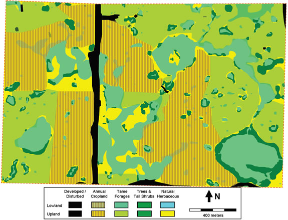
Long description for Figure 3
Figure 3 is a map of main habitats of upland and lowland within the boundaries of St. Denis National Wildlife Area. The map is in meters.
Upland ecosites have been modified by deliberate and unintended human activity over the last century. Most of the uplands were plowed for agricultural crop production at some point in the past. Most of that land is now dominated by annual weeds, annual crops, or perennial forages of European origin. Due to active fire suppression to protect infrastructure and forage supplies, many grassland habitats now support expanding patches of forest and shrubland habitats, including trembling aspen (Populus tremuloides), western snowberry (Symphoricarpos occidentalis), prairie rose (Rosa arkansana), and silverberry (Elaeagnus commutata). Patches of chokecherry (Prunus virginiana) and Saskatoon (Amelanchier alnifolia) are also common in the uplands, but have not spread like the other woody species. Due to exclusion of fire, grazing, or haying in the perennial cover at St. Denis NWA, unfettered seed production and wind dispersal of smooth brome, Kentucky bluegrass (Poa pratensis), Canada thistle (Cirsium arvense), perennial sow thistle (Sonchus arvensis), and yellow sweet clover has helped these alien species invade the ~40 ha of remnant native grasslands.
Lowland ecosites and ponds occupy 83 ha (22%) of St. Denis NWA, usually adjacent to wetlands that occupy the remaining 10% of the landscape in most years. In extremely wet years like 2011, ponds may expand and coalesce, and water may flood lowland ecosites to collectively occupy 22% of the NWA. Following droughts like those in 1968, 1989 or 2002, most ponds may be dry and only the 8 largest ponds support surface water totaling 1-2% of the NWA. Lowland ecosites consist of dark brown and black clay-loam soils of the humic gleysol, and gleyed chernozem suborders, with extensive areas of calcareous-salinity.
Terrestrial habitats in lowland ecosites include an expanding cover of woody vegetation, including species like trembling aspen (Populus tremuloides), balsam poplar (Populus balsamifera), and willow (Salix Species (spp.)). Grasslands vary along a gradient of salinity, with fresh sites occupied by bluegrasses (Poa spp.), reed grasses (Calamagrostis spp.) and sedges (Carex spp.). The most saline sites are occupied by desert salt grass (Distichlis spicata), foxtail barley (Hordeum jubatum), gumweed (Grindelia squarrosa), and red samphire (Salicornia rubra) (Hogan and Conly 2002; Thorpe 2007). Invasive alien species are common in these lowland habitats, represented primarily by quack grass (Elymus repens), smooth brome, and perennial sow thistle.
Aquatic habitats at St. Denis NWA include more than 200 basins (Figure 4) ranging from saline to fresh water chemistry, and ponds varying from temporary (n=124), to seasonal (n=76), to semi-permanent (n=13) classes (Millar 1976; Stewart and Kantrud 1971). Many wetlands with temporary ponds exist within the cultivated areas, while most seasonal and semi-permanent ponds are surrounded by a matrix of uncultivated wet meadows, shrublands, and grasslands (Figure 4). Common aquatic plants in wetlands at St. Denis NWA include emergents like cattail (Typha latifolia), bullrush (Scirpus spp.), spangletop (Scholochloa festucaceae), and pond smartweed (Polygonum cocineum), submergents like water milfoil (Myriophyllum exalbescens), and floating mats of duckweed (Lemna turionifera).
2.2 Wildlife
Over 100 species of birds have been recorded in the immediate area surrounding the St. Denis NWA. Breeding has been recorded or is suspected for over 75 of the bird species (Leighton 2002). On the NWA itself, the wetland and shrubland habitats support the largest number of bird species (Shutler et al. 2000). Populations of many birds are large enough on-site to have supported past research on mallard (Anas platyrynchos), gadwall (Anas strepera), blue-wing teal (Anas discors), green-wing teal (Anas crecca), canvasback (Aythya valisineria), American wigeon (Anas americana), lesser scaup (Aythya affinis), American crow (Corvus brachyrhynchos), and black-billed magpie (Pica pica) (e.g., Ignatiuk and Clark 1991; Pasitschinak-Arts et al. 1998; Gendron and Clark 2002). Tree swallows (Tachycineta bicolor) are very common due to the installation of 250 nest boxes for research on swallow survival and productivity (see Shutler and Clark 2003, Figure 5).
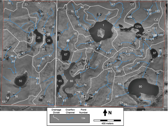
Long description for Figure 4
Figure 4 is a map of seasonal and semi-permanent ponds, overflow channels and major drainage divides within the boundaries of St. Denis National Wildlife Area. The map is in meters.
At least 19 species of mammals occur on St. Denis NWA. Upland soil and vegetation is frequently disturbed by earthen mounds created by northern pocket gophers (Thamomys talpoides), while wetland and lowland vegetation is impacted most by muskrats. A number of other mammals are abundant and significant predators of birds, eggs, and/or nestlings, including red fox (Vulpes vulpes), coyote (Canis latrans), raccoon (Procyon lotor), short-tailed weasel (Mustela erminea), American mink (Neovision vision), striped skunk (Mephitis mephitis), Franklin’s ground squirrel (Spermophilus franklinii), and thirteen-lined ground squirrel (Spermophilus tridecemlineatus) (see Pasitschinak-Arts et al. 1998). White-tailed deer (Odocoileus virginiana) and mule deer (Odocoileus hemionus) are frequently observed resting in forest and shrubland cover, and feeding in perennial forage crops.
Three amphibians are known to use the wetland and adjacent upland habitats at St. Denis NWA, including the wood frog (Rana sylvatica), boreal chorus frog (Pseudacris maculata), and Canadian toad (Bufo hemiophrys). Plains garter snakes (Thamnophis radix) are commonly found on south-facing slopes of the upland ecosites. No fish are known from the ponds.
Among invertebrates, several aquatic groups are abundant and important as food sources for wildlife or indicators of environmental change. Groups best represented at St. Denis NWA include crustaceans (e.g., Cladocera, Hyalella, or Gammarus spp.), insect larvae (e.g., Diptera, Ephemeroptera, Odonata), or adult beetles (e.g., Dyticidae, Chrysolemidae, Corixidae) (Driver 1977, Driver 1981, Euliss et al. 1999).
2.3 Species at risk
No Endangered Footnote2, Threatened, or Special Concern species currently or recently occupied St. Denis NWA. In the surrounding landscape there are breeding Sprague’s pipit (Anthus spragueii) - threatened, piping plover (Charadrius melodus) - endangered, loggerhead shrike (Lanius ludovicianus) - threatened, northern leopard frog (Lithobates pipiens) - special concern, and migrating whooping crane (Grus americana) - endangered and peregrine falcon (Falco peregrinus) - special concern (Leighton 2002). No critical habitat has been identified for any Species at Risk on the NWA.
Recently extinct or locally extirpated species from the St. Denis NWA and surrounding area include residents like plains bison (Bison bison), wapiti (Cervus canadensis), grizzly bear (Ursus arctos horribilis), wolf (Canis lupus), and migratory visitors like passenger pigeon (Ectopistes migratorius), eskimo curlew (Numenius borealis), and Rocky Mountain locust (Melanoplus spretus). Old bison wallows and rubbing stones on St. Denis NWA are direct evidence that bison formerly used the site.
3. Management challenges & threats
Because St. Denis NWA was intended to represent agricultural habitats typical of the surrounding region and landscape, many land use practices or ecological changes are not necessarily viewed as threats. Further, it is not possible to provide a report card on the relative health of St. Denis NWA in comparison to other NWAs across Canada, because non-native vegetation and anthropogenic disturbances are an intentional and desired component to sustain the research vision and goal. Instead, much of the land use is perhaps best viewed as an experimental treatment to which the NWA is subjected, and which the monitoring program is intended to describe and evaluate. In light of that context, the following threats or stressors are presented in order of priority (Table 3).
3.1 Intensification of agricultural practices
The primary potential stressor in the surrounding region and on-site is the change in agricultural practices and annual crop management, particularly the use of new pesticides (Donald et al. 2007). In 1967 it was most common to manage annual cropland with fallow rotations, whereby no crop would be grown for a year and instead multiple tillage operations would be used to help reduce weeds and increase soil moisture and available nitrogen. Burning crop stubble and wetland margins in spring or fall, and over-winter feeding of cattle on these croplands were also common practices at that time. These practices were possible because in 1967 most agricultural producers were small, family-based, mixed-farm operations.
| Management Challenges & Threats | Goals & Objectives | Management Approaches |
|---|---|---|
| Intensification of Agricultural Practices | 1(a,b,c,d,e), 2(a,b,c,d) | 5.1.1. Haying; 5.1.2. Revegetation; 5.1.3. Herbicide application; 5.1.4. Prescribed burning; 5.1.5. Livestock grazing; 5.2.1. Water quantity & flow control; 5.2.2. Water quality protection; 5.4. Monitoring |
| Invasive Plant Species | 1(a,b,d,e) | 5.1.1. Haying; 5.1.3. Herbicide application; 5.1.4. Prescribed burning; 5.1.5. Livestock grazing; 5.4. Monitoring. |
| Rural Residential Development | 2(a,b,c,d), 3(d) | 5.2.1. Water quantity & flow control; 5.2.2. Water quality protection; 5.4. Monitoring; 5.6. Public information program. |
| Increased Research Activity | 2(a,b,e), 3(a,b,c) | 5.2.1. Water quantity & flow control; 5.2.2. Water quality protection. 5.3. Wildlife population management; 5.4. Monitoring; 5.5.2. Research activity coordination and review; 5.6. Public information program. |
By 2011, practices of burning and mechanical fallow have declined in favour of retaining stubble to capture snow and using chemical herbicides to manage weeds. Over-winter feeding of cattle on stubble fields has also declined in favour of applying anhydrous ammonia or granulated fertilizers prior to or during seeding. The resulting zero-tillage, continuous cropping, and chemical-fallow techniques were devised to help reduce soil erosion, enhance soil fertility, and ultimately increase crop yields (Lafond et al. 1994). New equipment has also grown larger, which has been an incentive to drain wetlands and clear shrublands to simplify manoeuvrability and reduce input costs (Bartzen et al. 2010).
Some mix of these changed practices is represented in the annual cropland at St. Denis NWA, except there is no livestock feeding, wetland draining, or shrubland clearing. Instead it is largely changes in tillage frequency, agricultural chemicals, and crop varieties that have impacted upland soils and wetland catchments at St. Denis NWA. The challenge remains to determine if new conditions or restrictions should be placed on farmers operating under lease at St. Denis NWA, in order to continue protecting wildlife and the environment. Eventual phasing-out of annual cropland as part of a habitat restoration program is desired.
3.2 Invasive plant species
Vegetative cover on the NWA has changed significantly since lands were acquired in 1967. The major habitat types have changed in their proportions over the ensuing 45 years (Hogan and Conly 2002). This is partly due to natural expansion of the tree and shrub habitats, and partially due to planting of perennial forages on former annual cropland. Woody vegetation has increased in the absence of fire that would have normally limited the distribution and abundance of those species (Romo 2003).
Invasions by alien species are a regional phenomenon, facilitated in part by purposely seeding species like smooth brome and then failing to hay or graze the plant and allow it to set seed and spread unchecked within St. Denis NWA (Grilz and Romo 1995). Other species present on site or in the immediate landscape threaten the biological diversity and ecosystem function of grassland and wetland habitats, including: Kentucky bluegrass, yellow sweet clover, reed canary grass, purple loosetrife (Lythrum salicaria), and giant reed grass (Phragmites australis). Controlling these vegetation changes is a challenge in itself, since prescribed burning, herbicide spraying, or haying present their own logistical, safety and environmental risks. Largely because of those reasons, the vegetation changes have been allowed to continue uncontrolled for more than four decades.
3.3 Rural residential development
The St. Denis NWA site was selected, in part, because of proximity to the urban center of Saskatoon. Since 1967 it has become more common for Saskatoon workers to develop a residential property in the surrounding countryside and commute to work in the city. The hummocky moraine landscape has always been challenging to "improve" for agriculture by plowing and farming, and has traditionally had the lowest assessed property value and tax rate. Now those same properties are rapidly increasing in value for rural residential development because of the aesthetic viewscapes provided by hummocky terrain (see Bastian et al. 2002). Development density varies with subdivision lot size; usually in the range of 2 to 32 ha.
Edge effects of rural residential development on surrounding properties are not well understood. The City of Saskatoon (pop. 202,000 in 2006) is now supplying water lines to the more than 20,000 residents of these clustered rural developments and towns within a 30 km radius (Statistics Canada 2011). As a result, purified water from the South Saskatchewan River is coming into local drainage basins, but the continued reliance on septic fields for treating and disposing of wastewater means a net input of water to the system and increased risks of wetland eutrophication (see White and Bailey 2001). Rural residents often introduce many invasive alien species of ornamental plants, as well as predators of wildlife in the form of domestic cats (Felis domesticus) and dogs (Canis domesticus). Progressively fewer residents of the nearby Town of Vonda and surrounding Municipality of Grant #372 are involved in farming (Statistics Canada 2011), and commuter traffic to the City is increasing on rural roads like secondary #671. The increased traffic may lead to increased wildlife-vehicle collisions (Forman et al. 2003), and increased pressure for recreational access, both of which will be difficult to actively control.
Development is on-going in the landscape and watershed surrounding St. Denis NWA. In 2009 development began on two quarter sections 2 km north of the NWA, and one quarter section 5 km south of the NWA. In 2011, development began on the quarter section immediately north and adjacent to NW 28-37-1-W3. Thus, the adjacent and upstream land use has been changing from agricultural to rural residential. Associated with these developments have been road widening projects on secondary #671, first in the early 1980s and again in 2005. This N-S secondary road bisects the NWA. A 2" diameter potable water pipeline was also installed in the ditch on the W side of secondary #671 in 2009, to supply these residential developments.
3.4 Increased research activity
The increased human activity on the NWA for research, combined with agricultural activities, invasive species, and edge-effects of rural residential development may have cumulative effects on the site. Each human visit to the NWA has a small and possibly negligible impact on the wildlife present at the time, and may contribute in small and possibly negligible ways to cumulative adverse effects on vegetation, water and soils. However, the research proposed for March to October, 2011, involves 2000 to 4000 person-days of activity within the 383 ha site (Darcy Henderson pers. comm.), which likely poses adverse effects at concentrated access points, worksites, and regularly travelled routes. Further, many researchers have failed to comply with permit conditions and abandoned waste equipment used for short-term research projects over the past 40 years. This waste wood, metal, and plastic has accumulated throughout the NWA, but is largely concentrated next to the storage building.
Vehicle travel will compact soils along trails, introduce weed species, and under wet conditions can cause ruts or parallel trailing to occur. Installation of piezometers or removal of soil samples can involve heavy equipment, excavation and removal of soil. Wading into wetlands to obtain samples will create trails through emergent vegetation, mix otherwise stratified wetland sediments, and increase turbidity of the water column. Placement of shelters to protect flumes, erecting meteorological towers, installing fences, and erecting rows of nest boxes all have the potential to cause sensory disruption to some wildlife species. The artificially increased density of tree swallows on this relatively small property may result in exclusion of other insectivorous songbirds from the site. Simply walking through vegetation can have differential effects on the survival of plant species in communities (Cahill et al. 2001). These effects are real, but are they important in the context of St. Denis NWA, or the surrounding local and regional area?
Growth in the number of research collaborators and agencies is attributable to the increasingly valuable long-term monitoring of wildlife, water, and soil responses to changes in climate and land management. Proximity to Saskatoon for day-trip sampling has also helped attract research interest. Conversely, changes in technology and research approaches have very likely mitigated and reduced the impact of each individual researcher on the site, despite growth in the overall number of researchers. Non-destructive, in-situ measurements of water, air and soil chemistry using electronic probes or infra-red light have in many cases replaced the need for destructive sampling. Visual and auditory surveys of waterbird species are now practiced each year, where nest-dragging with vehicles was regularly done in the past. Although individual sampling efforts or experimental treatments seem small and short-term to the researchers involved, the cumulative effects of all activities on "valued ecosystem components" in the NWA (Hegmann et al. 1999), have not been fully quantified.
4. Goals & objectives
4.1 Vision
The long-term vision for St. Denis National Wildlife Area is research: the habitat will sustain high-quality research activity through the maintenance of natural wetland habitats, and implementation of alternative land use practices that restore or enhance upland habitats for wildlife; particularly migratory birds, species at risk, or rare or unique habitats.
4.2 Goals & objectives
Goal 1. Restore or enhance upland habitats for migratory birds, species at risk, or those that are rare or unique in the region on the St. Denis NWA.
- Objective. Continue annual hay cutting and baling practices on perennial forage croplands (up to 100 ha) to reduce the public safety risk of wild fire, reduce seed dispersal of invasive alien species, and improve nesting habitat for declining waterfowl like northern pintail, and species at risk like Sprague’s pipit.
- Objective. Within 5 years, burn at least once the upland native grassland and lowland meadow patches where shrubs are known to have expanded since 1983 (~50 ha), to reduce cover for generalist predators of migratory birds, increase nesting and foraging habitat for migratory birds, and increase the cover and occurrence of the regionally unique plains rough fescue.
- Objective. Within 10 years, revegetate all annual croplands on the NWA (~130 ha) to perennial grassland vegetation, primarily to benefit nesting and foraging habitat for migratory birds, to increase the cover and occurrence of the regionally unique plains rough fescue, and to facilitate watershed-scale research.
- Objective. Within 10 years, reintroduce grazing to perennial grasslands on the western third of the NWA (128 ha) with cross-fences placed along natural drainage divides to facilitate watershed-scale research, and to increase migratory bird habitat heterogeneity.
- Objective. Continue to control "noxious weeds" within 30 meters of road allowances and property boundaries in the NWA (~34 ha) to be compliant with the Saskatchewan Weed Control Act, Canada’s Invasive Alien Species Strategy, and Objectives b through d under Goal 1.
Goal 2. Maintain, enhance and restore the variety of natural wetland habitats characteristic of "prairie potholes" on the St. Denis NWA.
- Objective. Continue limiting physical works that would artificially drain or inundate the 205 ponds that are part of long-term wetland water-level monitoring, and key habitats for waterbirds and amphibians.
- Objective. Continue preventing intentional additions of deleterious substances or enrichment of isotopes and other tracer substances into surface and ground water. These substances can reduce wetland function for invertebrates and amphibian species at risk like the leopard frog, or otherwise disrupt the natural variation and long-term monitoring potential of water chemistry.
- Objective. Within 5 years, erect perimeter fences 30 m from the full supply level of the 13 permanent freshwater wetlands, to protect these water sources from future vegetation management activities involving livestock grazing. This will help conserve surface water quality, and protect habitats for wetland wildlife.
- Objective. Within 10 years, eliminate agricultural tillage, fertilizers and pesticides that contribute to adding deleterious substances to ponds, and increasing sedimentation, eutrophication, or chemical contamination of the surface water. This will help conserve surface and ground water quality, and protect habitats for wetland wildlife.
- Objective. Within 10 years, change the location of access trails and gates in perimeter fences to follow natural drainage divides between watersheds. This will simultaneously improve access for research, prevent vehicular traffic effects on overland flow and quality of runoff water, and protect habitats for wetland wildlife.
Goal 3. Communicate and coordinate with stakeholders on land use and research access decisions made for the St. Denis NWA.
- Objective. Continue to cooperate with researchers to coordinate permitted field work activities, promote compliance with permit conditions, and discuss future research plans through one or two annual meetings held after October 15 but before March 31 in each fiscal year.
- Objective. Begin requiring all permitted researchers to have all field staff attend a one-day event in the first week of May each year, where St. Denis management staff promote compliance with permit conditions and prohibited activities.
- Objective. Within 5 years, implement an information management system to make readily available to prospective researchers the detailed spatial and tabular records of past and present habitat management and permitted research activities.
- Objective. Within 5 years, begin offering a one-day event in the first week of July each year, where St. Denis NWA management staff and research permittees promote compliance with prohibited activities and describe permitted research activities to local residents, developers, and municipal government representatives.
4.3 Evaluation
Annual monitoring will be performed within the limits imposed by financial and human resources. The management plan itself will be reviewed in five years time and every ten years after that. Evaluation will take the form of an annual review of monitoring data obtained from the monitoring and research projects outlined below. These data and the annual review will be used to inform future management as well as to evaluate federal contributions towards accomplishing the mandates specific to EC for which the protected area was established.
5. Management approaches
This section contains a description of all the possible approaches that could be used in the management of the St. Denis National Wildlife Area. However, management actions will be determined during the annual work planning process and will be implemented as human and financial resources allow.
5.1 Upland habitat management
Two future directions in which wildlife habitat could be further improved at St. Denis NWA are to expand the area of perennial grassland cover, and diversify the structure and composition of that cover. Perennial upland cover is superior to annually tilled land as productive nesting and foraging habitat for many migratory birds and species at risk in the Prairie Ecozone (Greenwood et al. 1995; Davis et al. 1999; McMaster and Davis 2001). Greater variety in the structure and composition of that perennial upland cover is also known to support a greater variety of species relative to a monoculture or uniform harvest system (Askins et al. 2007; Rotenberry and Wiens 1980). For example, waterfowl nest density and success appear to increase on landscapes with many small wetlands and a patch-work of idled and managed perennial hay and annual cropland (Arnold et al. 2007). Some species, like northern pintail, may actually benefit from haying or otherwise managing perennial cover (McMaster et al. 2006). Thus, new management interventions could be used to achieve the goal of improving wildlife habitat.
Active management interventions to be employed will be gradual and phased-in to have the least impact on existing research and monitoring infrastructure. Collaborative planning of these habitat improvements and how best to monitor their effect on wildlife populations and habitats will be actively sought from current or recent research permitees on St. Denis NWA. Implementation of revegetation, prescribed burning, and livestock grazing will be designed to include whole watersheds wherever possible.
5.1.1 Haying
Haying of planted perennial forage crops at St. Denis NWA follows methods employed by farmers in the surrounding landscape, but follows a schedule prescribed by EC. Hay is only cut after July 15 to provide migratory birds with undisturbed nesting cover throughout the spring, and bales are removed from fields by August 31 before fall migration and any prescribed burning activities. The haying process involves three to six passes of heavy equipment >1 tonne, over the course of a week to a month, to swath, rake, bale, and remove the hay.
Haying will be used as an interim management intervention on existing fields of smooth brome and alfalfa, and other fields to be revegetated in future, until such time that the combination of revegetation and fencing for livestock grazing is completed. After that point, haying or otherwise mowing vegetation may only be used on a small scale as part of short-term experimental treatments, to prepare fire guards for prescribed burns, or to control woody and invasive alien vegetation.
5.1.2 Revegetation
Revegetation to expand the area and diversify the composition of perennial cover at St. Denis NWA could include planting seed mixes, greenhouse plugs, or bare-root seedlings of native plants or tame forages. Revegetation also has the added benefits of increasing soil carbon sequestration (Guzman and Al-Kaisi 2010), and filtering runoff or ground water. Ultimately, the annual cropland will be phased-out and planted perennial grasslands will dominate St. Denis NWA in future (Figure 6). Boundaries between planted cover types will follow natural drainage divides, and remnant native vegetation will be surrounded by planted native or non-invasive tame vegetation to facilitate long-term conservation.
Planting of trees and shrubs is not generally desired because that type of vegetation has been expanding naturally (Hogan and Conly 2002) and is recognized as a conservation problem for grasslands in the region (Romo 2003). Permitted exceptions to this general rule about tree and shrub planting include staking of native willows (Salix exigua, S. bebbiana, S. discolor, S. lutea, S. petiolaris, S. planifolia) as part of wetland restoration projects in currently cultivated landscapes, or planting of western snowberry seedlings at the base of north-facing slopes most susceptible to slumping or deposition of eroded sediment during the revegetation process.
Planting herbaceous perennial grassland species on currently cultivated annual croplands will be the priority action. The preference in species selection is to first expand the cover of plains rough fescue, second expand the cover of native grasses and forbs in upland and lowland ecosites (see Thorpe 2007 for typical species), and third seed non-invasive tame forages (i.e. intermediate wheat grass and meadow brome) as a dense nesting cover and buffer between native vegetation and smooth brome. For plains rough fescue it appears transplanting greenhouse plugs in spring is preferable to seeding this species at any time of year, as establishment from seed tends to be poor on recently reclaimed sites (Tannas 2011, Desserud 2011). For most other herbaceous perennials (Table 4) seeding between mid-May and mid-June is preferred to take advantage of peak soil moisture and maximize the frost-free period necessary for seedling establishment. Generally, largeseeded grasses and forbs will be planted using a tractor-drawn drill-seeder, while small-seeded grasses and forbs will be broadcast using an All-terrain vehicle (ATV)-mounted broadcaster with pull-behind harrows; resulting in at least two passes over the same area.

Long description for Figure 6
Figure 6 is a map of proposed planted cover types to restore or enhance wildlife habitats within the boundaries of St. Denis National Wildlife Area.
In anticipation of future restoration efforts, some lands currently planted to smooth brome and alfalfa could be converted to annual cropland for 2-3 years to reduce the seed and rhizome bank of these tame/alien invasive species, before seeding native species.
5.1.3 Herbicide application
Control of new invasive alien species or weeds identified as noxious under the Saskatchewan Weed Control Act, will employ chemical formulations and application timing prescribed by licensed pesticide applicators. All application methods will involve hand-held or ATV-mounted equipment to minimize disturbance to surrounding vegetation. Spot-spray applications of broad-leaf herbicides with limited residual effects will be used to target patches of the major problem species, like Canada thistle, toadflax, and perennial sow thistle throughout the NWA. Stem-wipe applications of broad-spectrum herbicides with strong residual effects will be used to target alien shrubs, like Siberian pea-shrub or lilac, in the abandoned farmstead. Spot-spray or wicking applications of glyphosate will be used to target small patches (<10 m2) of smooth brome or quack grass in remnant native grasslands. In all cases, no follow-up revegetation actions should be necessary, only monitoring the success of actions, and re-application where first efforts failed.
| Native Grass Mix Table Footnoted Species |
Native Grass Mix Table Footnoted % (PLS Table Footnotee) |
Dense Nesting Cover (DNC) Table Footnotef Species |
Dense Nesting Cover (DNC) Table Footnotef % Pure Live Seed (PLS) |
|---|---|---|---|
| Western porcupine grass | 32 | Intermediate wheatgrass | 35 |
| Northern wheatgrass | 15 | Meadow brome | 35 |
| Low, blunt, & thread-leaved sedges | 10 | Sheep fescue | 10 |
| Needle and thread | 9 | Canada wild rye | 10 |
| June grass | 6 | Slender wheatgrass | 10 |
| Fringed sagewort | 5 | Sainfoin | 5 |
| Western wheatgrass | 4 | blank | blank |
| Blue grama grass | 2 | blank | blank |
| Green needle grass | 2 | blank | blank |
| Hooker’s oat grass | 2 | blank | blank |
| Slender wheatgrass | 1 | blank | blank |
| Prairie crocus | 1 | blank | blank |
| Other forbs (40 species) Table Footnoteg | 7 | blank | blank |
| Other grasses (9 species) | 2 | blank | blank |
5.1.4 Prescribed burns
Prescribed burning up to 32 ha (8% of the NWA) may be undertaken in any year to reduce the cover of invasive native shrubs, alien perennial grasses, or litter build-ups that are otherwise a fire hazard. To minimize short-term negative effects on migratory birds, burning will be restricted to September and October after the nesting season has ended.
Burn units will focus on restoring remnant native grasslands, and maintaining planted native grasslands, in association with livestock grazing. Boundaries of burn units will include constructed features like gravel roads, open water bodies, or trails and mowed fire-guards that follow high ground divisions between watersheds. These boundary features either offer discontinuities in fuels (road, water), ease of equipment access (roads, trails), or are otherwise effective lines for ignition of backfires that will travel slowly down-slope. Burning whole catchments is also preferred to facilitate research or monitoring of fire effects on surface runoff. Backfires from these boundary features will be the primary form of ignition, with strip-fires or head-fires used only where a blackline or waterbody 10-15 meters in width occurs downwind and around the flanks. Burns will not occur where wind speeds exceed 25 km hour (hr)-1, to reduce the risk of long-distance ember transport from woody fuels or the risk of fires jumping fire guards (Cheney and Sullivan 2008). Individual burn units will not exceed 16 ha, in order to safely manage each fire with existing numbers of appropriately trained staff. Finally, burns will not occur during periods of fire bans dictated by surrounding municipal or provincial governments.
Other procedures, including the Ontario Herpetofaunal Summary (OHS) training requirements, pre-burn checklists, incident command system, post-fire mop-up, and cooperation with surrounding land owners and municipal fire departments, will be outlined in individual burn plans.
5.1.5 Livestock grazing
Grazing by domestic livestock can diversify the structure of perennial cover at St. Denis NWA. Two components of implementing livestock grazing include design of the grazing regime most appropriate for the ecosystem, and then constructing the infrastructure needed to support that grazing regime. Grazing regimes are described by timing, duration, frequency, and stocking density. Grazing rotations involve the movement of animals from one pasture to another, deferment involves delaying grazing in a pasture until most plants have completed seed production, and rest involves not grazing a pasture for at least one year (Heitschmidt and Stuth 1991).
To accommodate multiple management objectives and ensure a grazing patron can be found to supply the needed number of animals for the desired length of time, a five-pasture rotational grazing system will be used over a six month grazing season from May 1 to October 31 each year. This rotation will include one tame pasture that is permanently rested, two native pastures that are deferred and rested in alternating years, and two tame pastures which get used each year but are deferred in alternating years (Figure 7). Based on stocking rate recommendations for loamy ecosites in the dark brown soils on native and tame pastures (Pyle 1999), and the known land area inside each proposed pasture unit, the total average number of Animal Unit Months (AUMs) available each year are 336. For a six month grazing season, this means a herd of 46 Animal Unit Equivalents (AUE) can be grazed on the property. The number of days spent in each pasture will vary from year to year owing to the deferred, rest-rotation grazing system and the area of land minus water within each pasture (Figure 7, Table 5).
Tame forages are more productive overall and more grazing resistant than native grasslands under spring and summer utilization. Tame forages also produce taller cover for nesting waterfowl. Grazing in spring (May-June) or summer (July-August) will help reduce tame forage seed production or dispersal respectively, which will help conserve adjacent native grasslands. Summer regrowth of spring grazed pastures will provide a carry-over of litter suitable for waterfowl nesting the following spring, where grazing will be deferred until July. Deferred summer grazing will then reduce litter and create nesting conditions the following spring that are more appropriate for species desiring less cover.
Native pastures will be grazed every other year in fall (September-October) to help protect remnant and planted plains rough fescue that are sensitive to spring and summer grazing, facilitate establishment of other seeded native species, and generate litter carry-over sufficient to support prescribed burns in the alternating years.
| Pasture Name | Area (ha) | Dominant Cover | Recommended Stocking Rate Table Footnoteh | Days Grazed | Timing of Grazing |
|---|---|---|---|---|---|
| SE29-37-1-3 | 52 | Brome/Alfalfa & DNC | 1.8 AUM/ha | 65 | Even yrs: May 1-July 5 Odd years (yrs): Jul 16-Sep 19 |
| NE29-37-1-3 | 65 | Native | 1.0 AUM/ha | 40 | Even yrs: Sep 20-Oct 31 Odd yrs: rested |
| W½28-37-1-3 | 66 | Native | 1.0 Animal Unit Months/hectare (AUM/ha) | 40 | Even yrs: rested Odd yrs: Sep 20-Oct 31 |
| N½28-37-1-3 | 62 | Brome/Alfalfa | 1.8 AUM/ha | 75 | Even yrs: Jul 6-Sep 19 Odd yrs: May 1-Jul 15 |
| SE28-37-1-3 | 81 | DNC | 1.8 AUM/ha | 0 | Permanently rested |
Implementing the grazing regime will require fencing upgrades and new permit or lease agreements with livestock producers. The current fence posts surrounding the perimeter of the NWA are in excellent condition, but the 3-strands of high-tensile wire were placed on the outer-side of the posts to keep out stray livestock, rather than 4 strands of barbed-wire on the inner-side of the posts to keep in livestock. In addition to changing the wire on the perimeter fence, approximately 4 km of cross-fencing and new gates are necessary to implement the proposed grazing rotation. Additional water supplies for grazing animals should not be necessary in most years, as there is an abundance of natural wetlands, many with permanent water. No dugout or well construction to supply water for grazing animals is desirable in order to protect the integrity of the hydrological monitoring system. Where natural water supplies are insufficient during periods of drought, temporary troughs can be filled by solar pumps that draw from permanent wetlands outside the pasture fence (see Section 5.2.2).
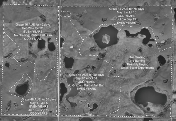
Long description for Figure 7
Figure 7 is a map of proposed fences and management regimes for prescribed burning and livestock grazing at St. Denis National Wildlife Area after revegetation is completed in 2016.
5.2 Wetland habitat management
Wetland habitats naturally fluctuate with changes in water level. Those changes in water level are driven by two primary factors: climate and land management. Only in the area of land management can wetlands be indirectly managed, by controlling the amount of runoff or groundwater seepage entering the wetland basin. Inputs associated with land management may also influence water quality through sedimentation, eutrophication or introduction of contaminants. Thus, some vegetation management approaches proposed in Section 5.1 will inevitably affect the wetlands. Where perennial grassland cover expands, water inputs to wetlands through runoff should decline due to greater capture and evapotranspiration losses of water in the adjacent uplands (van der Kamp et al. 1999). However, where the perennial cover was maintained in an undisturbed condition since 1967 or 1983, any haying or grazing disturbance may increase runoff.
5.2.1 Water quantity and flow control
Water quantity and flow manipulations are not generally desired for habitat management, as artificial reservoir filling or wetland drainage are known to have adverse environmental effects on some wildlife and wildlife habitats (Murkin 1998; Bartzen et al. 2010). As a federally protected area, conservation of wildlife and conservation of wetland function are legal or policy expectations (Government of Canada 1978, 2001). However, for experimental or public safety purposes, some manipulations may be permitted.
Overland flow between wetland basins was identified as a very important variable to measure by research collaborators of the St. Denis NWA Management Advisory Committee (St. Denis Management Advisory Committee (SDMAC)). To measure this flow most effectively and minimize environmental effects of that activity, the installation of "flumes" along natural gradients and within naturally narrow channels between basins may be permitted. Flumes are permanent structures with a metal or concrete base that channels overland flow through a known cross-sectional area to permit precise and accurate measurement of flow rate. While these flumes restrict flow in order to measure it, the flumes do not block flow or interfere with wetland function or area. Flume sheds with a footprint of <100 m2 and be placed >30 m from a wetland edge will minimize potential environmental effects, and are excluded as physical works under the Canadian Environmental Assessment Act.
Wetland basin levels could be manipulated only in basins classified as temporary ponds on cultivated uplands under annual or perennial crops. Naturally, temporary ponds are frequently dry by mid-summer or completely dry in half the years over a two decade period (Stewart and Kantrud 1971). No earth moving for drainage or plugging will be allowed. No transfer of water across property boundaries will be allowed. The total area affected by the combination of drainage and inundation resulting from pumping will not exceed 5% of the total number and area of ephemeral wetlands in a given year. Water quality at the donor and recipient wetlands will not be significantly different in key water quality indicators for protection of aquatic life (see Canadian Council of Ministers of the Environment (CCME) 2011). Pump motors and hoses will be temporary, placed on the surface, and removed after use. Filters and floats will be used at the distal end of intake hoses to minimize transfer of aquatic macrophytes, aquatic invertebrates, and wetland sediments from donor to recipient wetlands. Pumps and hoses will be continuously monitored to avoid leaks and accidental irrigation of uplands.
Water may also be pumped from permanent wetlands with a surface area >1 ha (~5,000,000 litres volume) for the purpose of fire control during suppression or prescribed burning activities. In these cases the water removed is returned to the same land base and watershed, and the volume removed for any one activity would be <1600 litres, or <0.2% of the wetland water volume. During droughts when water levels are at their lowest, upland vegetation would be too dry to safely carry out a prescribed burn, and thus no water removals would be necessary during those low level periods.
The restrictions described above on water quantity and flow control should be consistent with the "no net loss of wetland functions…and area" directive from the Federal Policy on Wetland Conservation, should qualify as "exclusions from requirement for permit" under subsection 11(1)(f) of The Drainage Control Regulations under The Saskatchewan Watershed Authority Act, and should result in no significant or adverse residual environmental effects under the Canadian Environmental Assessment Act.
5.2.2 Water quality protection
Vehicle traffic during the 2000 to 4000 person-days of activity on site each year could be problematic for water quality where existing trails cross low spots in the local terrain. In these locations vehicles come in contact with saturated soils and sometimes surface runoff. Rutting can expose soil to erosion, and where vehicles get stuck the efforts to remove them can cause local damage to vegetation and soil. One proactive management action to avoid these problems would be to relocate some trails to drier ridges that divide local catchments, instead of mid-slope crossings or wetland margin routes (Figure 8). Such an action would better protect the integrity of catchments for sampling surface and subsurface water flow. A second action is to institute a reactive wet-weather shut-down policy that prevents vehicle passage through sensitive trail segments during saturated conditions. Temporary signage and information sharing with permittees would be necessary to make this approach work. Approaches not desired for St. Denis NWA would be further infrastructure developments like culverts or raised and gravelled trail beds.
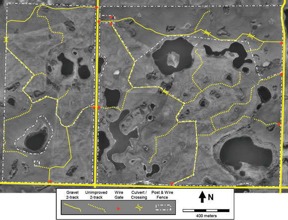
Long description for Figure 8
Figure 8 is a map showing the proposed trail network, gates, and low crossings at St. Denis National Wildlife Area to be implemented by 2016. The map is in meters.
Water quality and invertebrate communities would be expected to change significantly where large grazing animals have access to wetland basins. Where those changes are anticipated to adversely impact wildlife habitat and livestock health, or existing hydrological monitoring equipment, some wetlands and adjacent uplands may be fenced-off from grazing animal access. Pumping of water from those wetlands into adjacent livestock watering troughs would be acceptable, but only where those troughs occur in the same immediate basin watershed. In this way, any chemical or biological differences in the water will not be inadvertently transferred from one basin to the next. Pumps should use solar-based electricity, and fencing should not restrict the movement of migratory birds, small mammals, reptiles or amphibians. The volume of water removed from any wetland should not exceed 5% of the expected total wetland volume. These thresholds can actually be measured at St. Denis NWA, thanks to previous monitoring and modelling efforts (see Hayashi and van der Kamp 2000).
5.3 Wildlife population management
An on-going active population management of wildlife is the installation and maintenance of 250 nest boxes for tree swallow research that has been ongoing since 1990. This activity is permitted under the Wildlife Area Regulations and Migratory Bird Regulations, but the actual activity is undertaken by S&T-Wildlife and Landscape Science Directorate (WLSD) staff. This work is anticipated to continue until at least the end of 2013 (Bob Clark, pers. comm.).
Occasional removal of Canadian beaver or muskrats will be permitted where those animals are responsible for plugging flumes or culverts, or back-flooding municipal roadways. Humane removal methods of the animal, lodges, and any dams, as well as instituting follow-up prevention methods will follow the direction of a Provincial conservation officer and any applicable Provincial legislation.
No other active wildlife population management is anticipated for 2011-2016.
5.4 Monitoring
Various components of the St. Denis NWA ecosystem have been and will continue to be monitored and evaluated as part of research projects initiated by CWS and continued by S&T staff at Environment Canada. With respect to evaluating whether management goals and objectives were achieved, several additional variables require monitoring:
- Habitat suitability for grassland songbirds and prairie ducks, particularly Sprague’s pipit and northern pintail, using vertical obstruction and foliar cover measures for comparison to published habitat needs (Goal 1.a, 1.b, 1.c & 1.d).
- Plains rough fescue conservation arising from all management approaches, using cover and frequency measures, in the year treatments occurred and the year following (Goal 1.a, 1.b, 1.c, 1.d & 1.e).
- Woody vegetation reductions in response to burning treatments, using height and density measures, including before and after measurements with associated control and impact sites (Goal 1.b).
- Perennial vegetation establishment arising from revegetation efforts, using composition and cover measures, in the year seeding occurred and the year following (Goal 1.c).
- Rangeland and riparian (lentic) health assessments where lands are grazed by livestock, including before and after measurements with associated control and impact sites (Goal 1.d & 2.c).
- Noxious weed reductions following control methods employed, using cover, area or density measures appropriate to the target weed, in the year controls were applied and the year following (Goal 1.e).
- Adherence of permittee(s), local residents, developers, and municipal governments to prohibited activities and permit conditions (Goal 1.a, 1.d, 2.a, 2.b, 2.d, 2.e, 3.a, 3.b, 3.c & 3.d).
- Condition of facilities and infrastructure for consideration of repair, replacement, or decommissioning on an annual basis (Goal 3.a, 3.b & 3.c).
- Cumulative effects of habitat management and research activity, through records of CWS staff, agricultural activity lessees, and research activity permittees (Goal 3.c).
The results of the various monitoring activities will be considered in planning annual and ongoing management on the NWA. The management plan will be reviewed every ten years. Goals accomplished will be evaluated, and changes to monitoring may be made.
5.5 Research
To obtain a permit in order to conduct research in St. Denis National Wildlife Area and to receive specific instructions for permit applications, please contact:
Protected Areas Ecologist care of (c/o)
Environment Canada, Canadian Wildlife Service
115 Perimeter Road, Saskatoon, Saskatchewan, S7N 0X4.
5.5.1 Research scope and needs for St. Denis NWA
Unsolicited research activities will be considered for permitting when the results of the research have potential for:
- Conserving migratory bird populations, particularly waterfowl and grassland songbirds (Migratory Birds Convention Act).
- Conserving wildlife or wildlife habitats, particularly prairie wetlands and fescue prairie (Canada Wildlife Act).
- Protecting species at risk and their critical habitat (Species At Risk Act).
- Assessing the environmental effects of habitat management and research activities, or developing protocols for environmental effects monitoring programs (Canadian Environmental Assessment Act).
For clarity, the Wildlife Area Regulations define wildlife as "any animal, plant or other organism belonging to a species that is wild by nature or that is not easily distinguishable from such a species; and the habitat of any such animal, plant or other organism."
In addition to those unsolicited projects, any one of the topics listed under 5.4 Monitoring, could also serve as the basis for a research project that would directly contribute to management of the St. Denis NWA. Researchers are strongly encouraged to include one or more of those monitoring variables and treatment contrasts as part of a proposal to conduct related research at St. Denis NWA.
5.5.2 Research activity coordination and review
The ad-hoc St. Denis NWA Management Advisory Committee (SDMAC) was established to assist staff in decision making regarding permits for research, to collaborate with researchers on habitat management direction, and to provide a forum for researchers to coordinate activity timing and data sharing. Meetings should include EC staff from Environmental Stewardship Branch (ESB)-CWS, S&T - Wildlife and Landscape Science Directorate, and S&T - Water Science & Technology Directorate. SDMAC should also include other researchers involved with on-going and proposed studies at St. Denis NWA. SDMAC can recommend by vote or consensus whether a research permit request be approved as submitted, approved with modifications, or declined. CWS will take these recommendations into consideration when reviewing and screening applications for an NWA Permit.
In reviewing any request to use the St. Denis NWA for a research project, the following issues are key considerations:
- Application of the EC Protected Areas management principles (Conservation First, Precautionary Principle, Ecosystem Approach, Adaptive Conservation Approach).
- St. Denis NWA is primarily maintained as a "control" or "benchmark" site for long-term monitoring, and descriptive investigations of on-going management interventions.
- St. Denis NWA could support experimental manipulations of wildlife habitat, only if the proposed treatments will not have significant and adverse residual effects on the conservation of wildlife and the environment within the NWA.
Future manipulations must also be consistent with overall management goals and objectives, and compliant with legislation and policy affecting National Wildlife Areas.
Proposed research activities that do not meet the criteria above must include strongly compelling reasons why the research must be done at St. Denis NWA and no where else, and how that research will not interfere with the conservation of wildlife on the NWA, nor likely result in significant adverse environmental effects to the NWA. Nonetheless, those proposals may still be rejected by the wildlife area manager if the activity cannot be accommodated in light of other ongoing research.
5.6 Public information programs
No public access is allowed without a permit, because of the sensitive nature of research activities on-going at the site. However, the landscape surrounding St. Denis NWA is rapidly changing from agricultural to rural residential land use. New residents may have new desires for use of St. Denis NWA, or concerns about the agricultural and research activities on-going there. In addition, the longer research continues at St. Denis NWA, the more requests come for public tours associated with conferences, meetings, or university classes. Groups of 10 to 50 people on-site for an hour or two, and the expressed purpose of professional development, are unlikely to cause damage to the environment or infrastructure, but still require a permit for access under the Wildlife Area Regulations. Finally, there is much turnover in research staff among the graduate and summer students that use St. Denis NWA the most, and assumptions should not be made that principal investigators are consistently promoting compliance with permit conditions when these turnovers occur. Thus, to proactively continue conserving wildlife, protecting the research activity, carrying out habitat management activities, and protecting the health and safety of local residents, a public information program is required.
Two annual meetings will be held near to or on-site; one with local residents, and a second with all permitted researchers. At those meetings, audio-visual presentations and printed material will be made available to describe the history and purpose of St. Denis NWA, as well as a description of the habitats, land uses, and research activity on-going. Consultation from the groups will be sought regarding the most effective signage, fencing, gates, and other access controls that could be used at St. Denis NWA.
Local resident meetings will occur on a Saturday in July of each year, to maximize the number of potential participants among urban commuters and agricultural producers. Two main outcomes of local resident meetings include:
- Increasing awareness of the wildlife, natural history, and land use practiced in the surrounding landscape and watershed, and how this may affect or be affected by each individual resident.
- Increasing compliance with the prohibited activities at St. Denis NWA, including potential legal, health and safety risks associated with violating those prohibitions.
Research permittee meetings will occur on a Friday in the first two weeks of May each year, to ensure all technicians, graduate students, summer students, and volunteers can attend prior to the bulk of their field work beginning. Two main outcomes of research permittee meetings include:
- Increasing cooperation, and reducing conflict among researchers and agricultural lessees where timing or location of activities may overlap.
- Increasing compliance with permit conditions and prohibited activities at St. Denis NWA, including potential legal, health and safety risks associated with violating those prohibitions
Advertising, presentations, and printed material will be produced in cooperation with EC Communications staff to ensure the requirements of common look and feel, as well as Official Languages Act are respected. All materials will also be approved by the Regional Director EC-CWS to ensure messages are consistent with policy and regulations in effect at that time. Cooperation from permitted researchers will also be needed to prepare presentations on past research activity and the applications of that knowledge that are relevant to the two primary audiences. Hospitality expenses for both meetings would certainly help in delivering the messages effectively.
6. Prohibited activities and entry
Access to and use of the St. Denis NWA is authorised where notices have been posted or published in local newspapers. Unless posted or published, all activities in a National Wildlife Area are unauthorised. However, a permit may be obtained from the Minister of Environment authorising certain activities to take place.
For the benefit of wildlife and its environment, human activities are minimised and controlled in National Wildlife Areas through the implementation of the Wildlife Area Regulations. These regulations set out activities that are prohibited (subsection 3(1)) and provide mechanisms for the Minister of the Environment to allow for certain activities to take place in National Wildlife Areas that are otherwise considered prohibited. They also provide the authority to the Minister to prohibit entry into National Wildlife Areas.
6.1 Authorisations
Under the Wildlife Area Regulations, the Minister of the Environment may authorise an activity that is prohibited through the issuance of permits and notices issued in local newspaper or posted at the entrance of any wildlife area or on the boundary of any part thereof.
Authorisations may be issued only if the Minister is of the opinion that the activity: is scientific research relating to wildlife or habitat conservation, benefits the wildlife and their habitats or will contribute to wildlife conservation, or is otherwise consistent with the criteria and purpose for which the NWA was established as stated in this management plan. These conditions must be met before the Minister will consider authorising a prohibited activity.
Terms and conditions governing the activity may be added to the authorisations for which the Minister considers necessary that they are added for protecting and minimising the impact of the authorised activity on wildlife and their habitat.
All permit requests must be made in writing to:
Protected Areas Ecologist c/o
Environment Canada, Canadian Wildlife Service
115 Perimeter Road, Saskatoon, Saskatchewan, S7N 0X4.
6.2 Authorised activities
There are no authorized activities within St. Denis NWA that do not require a permit.
6.3 Exceptions
The Wildlife Area Regulations allow for exceptions to the prohibited activities under the following circumstances:
- Activities related to public safety, health or national security, that are authorised by or under another Act of Parliament or activities under Health of Animals Act and the Plant Protection Act for the health of animals and plants;
- Activities related to routine maintenance of National Wildlife Areas, to the implementation of management plans, and enforcement activities conducted by an officer or employee of Environment Canada.
6.4 Other federal and provincial authorisations
Depending on the type of activity, other federal or provincial permits may be required to undertake an activity in the St. Denis NWA.
Contact your regional federal and provincial permitting office for more information.
Protected Areas Ecologist c/o
Environment Canada, Canadian Wildlife Service
115 Perimeter Road, Saskatoon, Saskatchewan, S7N 0X4.
Province of Saskatchewan, Ministry of Environment
3211 Albert Street, Regina, Saskatchewan, S4S 5W6.
6.5 Prohibition of entry
Under the Wildlife Area Regulations, the Minister may post notices at the entrance of any wildlife area or on the boundary of any part thereof prohibiting entry to any wildlife area or part thereof. These notices can be posted when the Minister is of the opinion that entry is a public health and safety concern and when entry may disturb wildlife and their habitat.
For St. Denis NWA, entry is prohibited under the following circumstances:
- Persons without a valid permit outlining their access permissions.
A posted notice of prohibited entry is at all 4 access gates to the St. Denis NWA.
7. Health & safety
In the case of environmental emergencies, contact will be made with the Canadian Environmental Emergencies Notification System.
All reasonable efforts will be made to protect the health and safety of the public including adequately informing visitors of any known or anticipated hazards or risks. Further, Environment Canada staff will take all reasonable and necessary precautions to assure their own health and safety and that of their co-workers. However, visitors (including researchers and contractors) must make all reasonable efforts to inform themselves of risks and hazards and must be prepared and self-sufficient. Natural areas are inherently dangerous and proper precautions must be taken by visitors, recognising that Environment Canada staff neither regularly patrol nor offer services for visitor safety in National Wildlife Areas.
A Phase 1 environmental site assessment, and preliminary Phase 2 assessment identified no areas of potential environmental concern at St. Denis NWA (Franz Environmental 2006). To ensure St. Denis NWA remains in this state, a number of proactive management activities are recommended below.
7.1 Fire prevention and protection of facilities & infrastructure
Dry grass and woody litter from adjacent shelterbelts have accumulated surrounding the steel clad building at St. Denis NWA, and pose a potential risk of wild fire causing property and habitat damage. Where some experimental items have been stored (i.e. wire live traps, plastic mesocosm tubes, wooden pen panels), vegetation has grown between or through the material, complicating the task of managing dry fuels proactively or extinguishing an actual fire reactively.
Vegetation should be actively managed within at least 3 m of permanent structures, including the mowing of grassy fuels, and pruning/removal of dead woody fuels. To reduce the need for follow-up treatment and improve drainage for emergency access surrounding the building, a gravel strip 1 m wide should be placed around the base of the steel clad building at a grade below the level of the concrete floor. Research equipment will no longer be temporarily stored within 3 m of the storage building. Existing waste wood, metal, and plastic shall be removed and disposed of in a municipal landfill.
A condition for all permittees will be to have fire extinguishers co-located with all combustion engine vehicles, generators, or equipment. Wild fires can be started in dry grassy fuels, during hot and dry weather, simply from contact with the heated metal of combustion engine parts. For this reason, vehicles should remain on designated trails. Similarly, generators or equipment should not, under any circumstances, be placed in dry grassy fuels during or immediately following operation.
Access restrictions may be used when fire hazards are "Extreme", based on the fire danger rating system the daily fire weather forecast maps produced by the Canadian Forest Service. Road block signs will be used to inform permittees if some trails are temporarily closed, and that motorized equipment is not allowed off of gravelled trails until fire hazards decrease. Those same signs could be used during prescribed burn activities for site management.
7.2 Wet-weather shutdown for vehicles on trails
Damage to habitats by vehicles travelling on trails in wet weather has already been discussed (Sections 4.3 and 5.2.2). To promote environmental protection as well as the health and safety of permitted site users, all future permits should contain the condition that vehicular access should cease when there is:
- rutting of topsoil >10 cm deep, such that topsoil and subsoil mixing may occur;
- excessive wheel slip in the direction of travel or laterally, such that trails are widened or mud is splattered off-trail;
- excessive build-up of soil on tires and cleats, such that weed seeds are transported and manoeuvrability of vehicles is compromised; or
- formation of puddles on trail surfaces, indicative of soil compaction.
- Vehicular activity can resume when soils have either dried or frozen to avoid the situations above. During warm summer weather with actively growing vegetation, delays post rainfall events may be as short as 30 minutes. During cool spring weather with substantial snowmelt and runoff, delays of several days or weeks may be expected. Road block signs could be used during these extended periods to temporarily close trails and help minimize risk.
7.3 Waste disposal procedures
No waste disposal facilities are provided at St. Denis NWA, and all waste materials (organic, recyclable, or non-recyclable) must be removed at the end of each day by those who generate the waste. All permittees must bring containers suitable for removal of those waste materials.
Researchers may provide temporary toilet facilities (i.e., composting toilets, port-apotty, etc.), which can be permitted to remain on site for <200 consecutive days in a year. With somewhere between 2000 and 4000 person-days of activity on this 383 hectare site, considerable volumes of human waste are expected to be generated, and must be disposed of off-site.
8. Enforcement
No cooperative agreements for enforcement and surveillance have been developed with other competent authorities, such as other government departments and agencies (Royal Canadian Mounted Police (RCMP), Department of National Defence (DND), et cetera (etc.)), provinces and territories, or any local or municipal authorities.
Informally, EC enforcement officers in Saskatoon have been given a list of properties where permits have been issued for agricultural or research activities each year. This list helps them plan their work with responses to complaints or regular inspections of properties.
9. Plan implementation
Details of management plan implementation will be developed through Environment Canada’s annual work planning process and will be implemented as human and financial resources allow.
High priority annual or ongoing tasks needed to support the vision and accomplish the goals and objectives, include:
- Coordinating, reviewing, permitting, monitoring, and recording research activity. This will include holding 1 to 2 annual meetings with research collaborators in Saskatoon, and timely review and issuing of permits.
- Negotiating, permitting, monitoring, and recording agricultural lease or contract activity. This will include communication with current and prospective lease holders.
- Inspecting condition of facilities and infrastructure, and making repairs where necessary to continue sustaining research activity and protecting the site.
- Re-routing designated trails to facilitate upland and wetland habitat management approaches and better ensure health and safety of trail users.
- Selecting baseline monitoring sites and completing baseline inventories in support of all proposed vegetation or wetland management interventions, and the cumulative effects assessment.
Medium priority tasks, required once within the 2012-2016 period to support the vision and accomplish the goals and objectives, include:
- Controlling noxious weeds on-site, including contracting for pesticide applicator when necessary, and follow-up monitoring of success.
- Revegetating annual croplands on the NWA. This will include acquiring seed, propagating plants, site preparation, seeding, planting, and follow-up weed control and monitoring.
- Monitoring any infrastructure installation and decommissioning, such as flumes, tanks for mesocosm studies, nest boxes, piezometers, and trails.
- Burning shrubland patches in perennial grassland vegetation.
- Upgrading fencing, selecting water sources, and protecting water quality or research infrastructure prior to any grazing activity.
Low priority tasks, are likely to involve researcher and not site manager responsibilities, or cannot take place unless all high and medium priority tasks are undertaken, include:
- Developing and managing a spatial and tabular record management system to share information between researchers and managers. At present most data is held by research collaborators, and managed externally to CWS.
- Negotiating, permitting, monitoring, and recording grazing lease activity. This can only take place after revegetation, fence upgrades, water supply provision, and infrastructure protection has been successfully completed.
- Analyzing data and writing up results of a cumulative effects assessment.
9.1 Management plan review
Management plans will be reviewed 5 years after initial acceptance and every 10 years after that.
10. Collaborators
Collaborative arrangements have developed within EC between ESB-CWS (Protected Areas and Stewardship), S&T - WLSD (Wildlife and Landscape Science Directorate) and NHRC (National Hydrology Research Centre) to support research programs on St. Denis NWA. Also, these parties have individually or collectively developed additional arrangements with other groups to facilitate research programs, including Ducks Unlimited Canada, University of Saskatchewan, and University of Regina, among others. The ad-hoc St. Denis NWA Management Advisory Committee (SDMAC) was established to assist the CWS staff in decision making specifically related to screening requests for new research studies on the site. The SDMAC may call upon the assistance of any other researchers involved in studies at St. Denis NWA if required.
11. Literature cited
Arnold, T.W., Craig-Moore, L.M., Armstrong, L.M., Howerter, D.W., Debries, J.H., Joynt, B.L., Emery, R.B. and Anderson, M.G. 2007. Waterfowl use of dense nesting cover in the Canadian parklands. Journal of Wildlife Management. 71: 2542-2549.
Askins, R. A., F. Chavez-Ramirez, B. C. Dale, C. A. Haas, J. R. Herkert, F. L. Knopf, and P. D. Vickery. 2007. Conservation of grassland birds in North America: Understanding ecological processes in different regions. Ornithological Monographs. 64:1-46.
Baines, G.B.K. 1964. Plant distributions on a Saskatchewan prairie in relation to edaphic and physiographic factors. Master of Science (MSc) thesis. University of Saskatchewan. Saskatoon SK.
Bartzen, B.A., Dufour, K.W., Clark, R.G. and Caswell, F.D. 2010. Trends in agricultural impact and recovery of wetlands in prairie Canada. Ecological Applications. 20: 525-538.
Bastian, C.T., McLeod, D.M., Germino, M.J., Reiners, W.A. and Blasko, B.J. 2002. Environmental amenities and agricultural land values: a hedonic model using geographic information systems data. Ecological Economics. 40: 337-349.
Cahill, J.F., Castelli, J.P. and Casper, B.B. 2001. The herbivory uncertainty principle: Visiting plants can alter herbivory. Ecology. 82: 307-312.
Canadian Wildlife Service. 1983. St. Denis National Wildlife Area, Saskatchewan: Management plan. Unpublished report, Canadian Wildlife Service. Saskatoon SK.
CCME. 2011. Canadian environmental quality guidelines. Canadian Council of Ministers of the Environment. Ottawa Ontario (ON).
Cheney, P. and A. Sullivan. 2008. Grassfires: Fuel, weather and fire behaviour, 2nd edition. CSIRO Publishing. Collingwood, Victoria, Australia (AU).
Coupland, R.T. and T.C. Brayshaw. 1953. The fescue grassland in Saskatchewan. Ecology 34: 386- 405.
Davis, S.K., Duncan, D.C. and Skeel, M. 1999. Distribution and habitat associations of three endemic grassland songbirds in southern Saskatchewan. Wilson Bulletin. 111: 389-396.
Desserud, P. 2011. Rough fescue (Festuca hallii) ecology and restoration in central Alberta. Doctor of Philosophy (PhD) thesis, University of Alberta. Edmonton AB.
Donald, D.B., Cessna, A.J., Sverko, E. and Glozier, N.E. 2007. Pesticides in surface drinking-water supplies of the northern Great Plains. Environmental Health Perspectives. 115: 1183-1191.
Environment Canada. 2011. Canadian climate normals 1971-2000 (accessed on-line March 31, 2011).
Euliss, Ned H., Jr., David M. Mushet, and Dale A. Wrubleski. 1999. Wetlands of the Prairie Pothole Region: Invertebrate Species Composition, Ecology, and Management. Pages 471-514 in D. P. Batzer, R. B. Rader and S. A. Wissinger, editors (eds). Invertebrates in Freshwater Wetlands of North America: Ecology and Management, Chapter 21. John Wiley & Sons, New York.
Forman, R.T.T. et al. 2003. Road ecology: science and solutions. Island Press. Washington District of Columbia (DC).
Franz Environmental. 2006. Phase I Environmental Site Assessment, St. Denis National Wildlife Area; Final report.
Fung, K. 1999. Atlas of Saskatchewan. Second Edition. University of Saskatchewan, Saskatoon, Saskatchewan (SK).
Gendron, M. and Clark, R.G. 2002. Survival of gadwall and mallard ducklings in southcentral Saskatchewan. Journal of Wildlife Management. 66: 170-180.
Government of Canada. 1978. Wildlife Area Regulations. Statutes of the Government of Canada. Ottawa ON.
Government of Canada. 1991. The federal policy on wetland conservation. Environment Canada, International Standard Book Number (ISBN) 0-662-18940-X. Ottawa ON.
Greenwood, R.J., Sargeant, A.B., Johnson, D.H., Cowardin, L.M. and Shaffer, T.L. 1995. Factors associated with duck nest success in the Prairie Pothole Region of Canada. Wildlife Monographs. 128:1-57.
Grilz, P.L. and Romo, J.T. 1995. Management considerations for controlling smooth brome in fescue prairie. Natural Areas Journal. 15: 148-156.
Guzman, J.G. and M. Al-Kaisi. 2010. Landscape position and age of reconstructed prairies effect on soil organic carbon sequestration rate and aggregate associated carbon. Journal of Soil and Water Conservation. 65: 9-21.
Hayashi, M. and van der Kamp, G. 2000. Simple equations to represent the volume-area-depth relations of shallow wetlands in small topographic depressions. Journal of Hydrology. 237: 74- 85.
Hegmann, G., C. Cocklin, R. Creasey, S. Dupuis, A. Kennedy, L. Kingsley, W. Ross, H. Spaling and D. Stalker. 1999. Cumulative Effects Assessment Practitioners Guide. Prepared by AXYS Environmental Consulting Ltd. and the CEA Working Group for the Canadian Environmental Assessment Agency. Hull QB.
Heitschmidt, R.K. and J.W. Stuth (eds) 1991. Grazing management: An ecological perspective. Timber Press. Portland OR.
Hogan, J. M. and F. M. Conly. 2002. St. Denis National Wildlife Area Land Cover classification: 1997. Technical Report Series No. 384, Canadian Wildlife Service. Saskatoon SK.
Ignatiuk, J.B. and Clark, R.G. 1991. Breeding biology of American crows in Saskatchewan parkland habitat. Canadian Journal of Zoology. 69: 168-175.
Lafond, G.P., Derksen, D.A., Loeppky, H.A. and Struthers, D. 1994. An agronomic evaluation of conservation-tillage systems and continuous cropping in East Central Saskatchewan. Journal of Soil and Water Conservation. 49: 387-393.
Leighton, A.L. (ed). 2002. Birds of the Saskatoon Area. Special publication no. 23, Nature Saskatchewan. Regina SK.
McKercher, R.B. and Wolfe, B. 1997. Understanding Western Canada’s Dominion Land Survey System. University of Saskatchewan Extension Press. Saskatoon SK.
McMaster, D.G. and Davis, S.K. 2001. An evaluation of Canada’s permanent cover program: Habitat for grassland birds? Journal of Field Ornithology. 72: 195-210.
McMaster, D.G., Devries, J.H. and Davis, S.K. 2005. Grassland birds nesting in haylands of southern Saskatchewan: landscape influences and conservation priorities. Journal of Wildlife Management. 69: 211-221.
Millar, J.B. 1976. Wetland classification in Western Canada: A guide to marshes and shallow open water wetlands in the grasslands and parklands of the Prairie Provinces. Technical Report Number 37, Canadian Wildlife Service. Saskatoon SK.
Murkin, H.R. 1998. Freshwater functions and values of prairie wetlands. Great Plains Research. 8: 3-15.
Papiernik, S.K., Lindstrom, M.J., Schumacher, J.A., Farenhorst, A., Stephens, K.D., Schumacher, T.E. and Lobb, D.A. 2005. Variation in soil properties and crop yield across an eroded prairie landscape. Journal of Soil and Water Conservation. 60: 388-395.
Pasitschniak-Arts, M., Clark, R.G. and Messier, F. 1998. Duck nesting success in a fragmented prairie landscape: Is edge effect important? Biological Conservation. 85: 55-62.
Pyle, W.(ed) 1999. Managing Saskatchewan Rangeland, revised edition. Grazing and Pasture Technology Program, Saskatchewan Agriculture. Regina SK.
Romo, J.T. 2003. Reintroducing fire for conservation of fescue prairie association remnants in the northern Great Plains. Canadian Field Naturalist. 117: 89-99.
Rotenberry, J.T. and Wiens, J.A. 1980. Habitat structure, patchiness, and avian communities in North American steppe vegetation: a multivariate analysis. Ecology. 61: 1228-1250.
Shutler, D. and Clark, R.G. 2003. Causes and consequences of tree swallow (Tachycineta bicolour) dispersal in Saskatchewan. The Auk. 120: 619-631.
Shutler, D., Mullie, A. and Clark, R.G. 2000. Bird communities of prairie uplands and wetlands in relation to farming practices in Saskatchewan. Conservation Biology. 14: 1441-1451.
Statistics Canada. 2011. 2006 Census of Population: Community Profiles. Accessed electronically, April 20, 2011.
Stewart, R.E. and Kantrud, H.A. 1971. Classification of natural ponds and lakes in the glaciated prairie region. Resource Publication 92, United States Fish and Wildlife Service. Washington DC.
Sugden, L.G. and Beyersbergen, G.W. 1985. Prediction of duck nest survival in conventional and zero-tilled fields. Canadian Wildlife Service, Progress Notes 156: 1-3.
Tannas, S. 2011. Rough fescue grassland restoration in the Alberta foothills. PhD thesis, University of Alberta. Edmonton AB.
Thorpe, J. 2007. Saskatchewan rangeland ecosystems: Ecoregions and ecosites. Publication no. 11881-1E07, Saskatchewan Research Council. Saskatoon SK.
Töyrä, J., A. Pietroniro, M. Craymer and M. Véronneau. 2008. Evaluation of LiDAR-derived ground surface digital elevation model (DEM) in low-relief regions: Case study on the Canadian Prairies. Pages 301-326 in: Hopkinson, C., Pietroniro, A. and J.W. Pomeroy. 2008 HYDROSCAN: Airborne Laser Mapping of Hydrological Features and Resources. Canadian Water Resources Association. Cambridge ON.
van der Kamp, G., W. J. Stolte, and R. G. Clark. 1999. Drying out of small prairie wetlands after conversion of their catchments from cultivation to permanent brome grass. Journal of Hydrological Sciences. 44:387-397.
White, J.S. and S.E. Bayley. 2001. Nutrient retention in a northern prairie marsh (Frank Lake, Alberta) receiving municipal and agro-industrial wastewater. Water, Air, and Soil Pollution. 126: 63-81.
Appendix 1. St. Denis NWA research publications (to 2010)
- Armstrong, R.L., Pomeroy, J.W. and L.W. Martz. 2008. Evaluation of three evaporation estimation methods in a Canadian prairie landscape. Hydrological Processes. 22: 2801-2815.
- Armstrong, R.N., J.W. Pomeroy, and LW. Martz. 2010. Estimating evaporation in a Prairie landscape under drought conditions. Canadian Water Resources Journal. 35: 173-186.
- Arnold, T.W. and Clark, R.G. 1996. Survival and philopatry of female dabbling ducks in southcentral Saskatchewan. Journal of Wildlife Management. 60: 560-568.
- Arts, M.T., Robarts, R.D., Kasai, F., Waiser, M.J., Tumber, V.P., Plante, A.J., Rai, H., de Lange. H.J. 2000. The attenuation of ultraviolet radiation in high dissolved organic carbon waters of wetlands and lakes on the northern Great Plains. Limnology and Oceanography. 45: 292-299.
- Bartzen, B. 2008. Wetland characteristics and abundance of breeding ducks in Prairie Canada. M.Sc., University of Saskatchewan. Saskatoon.
- Beauchamp, W.D., R.R. Koford, T.D. Nudds, R.G. Clark & D.H. Johnson. 1996. Declines in nest success of prairie ducks detected using long-term data. Journal of Wildlife Management. 60: 247-257.
- Beauchamp, W.D., T.D. Nudds & R.G. Clark. 1996. Duck nest success declines with and without predator control. Journal of Wildlife Management. 60: 258-264.
- Bedard-Haughn, A. 2001. Terrain controls on depressional soil formation in a hummocky morainal landscape. M.Sc. thesis, University of Saskatchewan. Saskatoon SK.
- Bedard-Haughn, A., Jongbloed, F., Akkerman, J., Uijl, A., de Jong, E., Yates, T. and Pennock, D. 2006. The effects of erosional and management history on soil organic carbon stores in ephemeral wetlands of hummocky agricultural landscapes. Geoderma. 135: 296-306.
- Bedard-Haughn, A. K., Matson, A. L. and Pennock, D. J. 2006. Land use effects on gross nitrogen mineralization, nitrification, and N2O emissions in ephemeral wetlands. Soil Biology and Biochemistry. 38: 3398-3406.
- Bedard-Haughn, A.K.,Tate, K.W. and van Kessel, C. 2005. Quantifying the impact of regular curing on vegetative buffer efficacy for 15N uptake. Journal of Environmental Quality. 34: 1651- 1664.
- Bedard-Haughn, A.K. and Pennock, D.J. 2002. Terrain controls on depressional soil distribution in a hummocky morainal landscape. Geoderma. 110: 169-190.
- Berthold, S., Bentley, L.R. and Hayashi, M. 2004. Integrated hydrogeological and geophysical study of depression-focused groundwater recharge in the Canadian prairies. Water Resources Research. 40:.
- Bodhinayake, W. and Si, B.C. 2004. Near-saturated surface soil hydraulic properties under different land uses in the St. Denis National Wildlife Area, Saskatchewan, Canada. Hydrological Processes. 18: 2835-2850.
- Bollinger, T., G. Wobeser, R.G. Clark, D.J. Nieman & J.R. Smith. 1989. Concentration of creatine kinase and aspartate aminotransferase in the blood of wild mallards following capture by three methods for banding. Journal of Wildlife Diseases. 25: 225-231.
- Brook, R.W. & R.G. Clark. 2002. Retention and effects of nasal markers and subcutaneously implanted radio transmitters on breeding female lesser scaup. Journal of Field Ornithology. 73: 206-212.
- Clark, R.G., K.A. Hobson & L.I. Wassenaar. 2006. Geographic variation in the isotopic composition (δD, δ13C, δ15N, δ34S) of lesser scaup and northern pintail feathers and claws: implications for studies of migratory connectivity. Canadian Journal of Zoology. 84: 1395-1401.
- Clark, R.G., Leach, S.W., Dufour, K.W. and Gendron, M. 2005. Wetland fidelity of female mallard Anas platyrhynchos and gadwall Anas strepera during brood rearing. Wildfowl. 55: 17-30.
- Clark, R.G., Meger, D.E. and Ignatiuk, J.B. 1995. Removing American crows and duck nesting success. Canadian Journal of Zoology. 73: 518-522.
- Clark, R.G. & T.D. Nudds. 1991. Habitat patch size and duck nesting success: the crucial experiments have not been performed. Wildlife Society Bulletin. 19: 534-543
- Clark, R.G. and Shutler, D. 1999. Avian habitat selection: patterns from process in nest-site use by ducks? Ecology. 80: 272-287.
- Clark, R.G., L.G. Sugden, R.K. Brace & D.J. Nieman. 1988. The relationship between nesting chronology and vulnerability to hunting of dabbling ducks. Wildfowl. 39: 137-144.
- Clark, R.G & B.K. Wobeser. 1997. Making sense of scents: effects of odour on survival of simulated duck nests. Journal of Avian Biology. 28: 31-37.
- Conly F. M. and G. van der Kamp. 2001. Monitoring the hydrology of Canadian Prairie wetlands to detect the effect of climate change and land use changes. Environmental Monitoring and Assessment. 67: 195-215.
- Conly, F.M., Su, M., van der Kamp, G. and Millar, J.B. 2004. A practical approach to monitoring water levels in prairie wetlands. Wetlands. 24: 219-226.
- Coulton, D. 2008. Recruitment patterns and processes in Canadian Parkland mallards. Ph.D. thesis University of Saskatchewan. Saskatoon SK.
- Coulton, D.W. & R.G. Clark. 2008. An integrated capture-recapture and stable isotope approach to modeling sources of demographic rescue. Auk. 125: 923-931.
- Coulton, D.W., R.G. Clark & C.E. Hebert. 2010. Determining natal origins of birds using stable isotopes (δ34S, δD, δ15N, δ13C): model validation and spatial resolution for mid-continent mallards. Waterbirds. 33: 10-21.
- Coulton, D.W., Clark, R.G., Hobson, K.A., Wassenaar, L.I. and Hebert, C.E. 2009. Temporal sources of Deuterium (δ D) variability in waterfowl feathers across a prairie-to-boreal gradient. The Condor. 111: 255-265.
- Dawson, R.D. and Clark, R.G. 1996. Effects of variation in egg size and hatching date on survival of less scaup Aythya affinis ducklings. Ibis. 138: 693-699.
- Dawson, R.D. and Clark, R.G. 2000. Effects of hatching date and egg size on growth, recruitment and adult size of lesser scaup. The Condor. 102: 930-935.
- Degenhardt, D., Cessna, A.J., Raina, R., Pennock, D.J. and Farenhorst, A. 2010. Trace level determination of selected sulfonylurea herbicides in wetland sediment by liquid chromatography electospray tandem mass spectrometry. Journal of Environmental Science and Health, Part B. 45: 11-24.
- Drever, M.C. & R.G. Clark. 2007. Spring temperature, clutch initiation date, and duck nest success: a test of the mismatch hypothesis. Journal of Animal Ecology. 76: 139-148.
- Drever, M.C., T.D. Nudds & R.G. Clark. 2007. Agricultural policy and nest success of prairie ducks in Canada and the United States. Avian Conservation & Ecology. 2: open access.
- Drever, M.C., A. Wins-Purdy, T.D. Nudds & R.G. Clark. 2004. Decline of duck nest success revisited: relationships with predators and wetlands in dynamic prairie environments. Auk. 121: 497-508.
- Driver, E.A. 1981. Calorific values of pond invertebrates eaten by ducks. Freshwater Biology. 11: 579-581.
- Driver, E.A. 1977. Chironomid communities in small prairie ponds: Some characteristics and control. Freshwater Biology. 7: 121-133.
- Driver, E.A. and Peden, D.G. 1977. The chemistry of surface water in prairie ponds. Hydrobiologia. 53: 33-48.
- Dufour, K.W. and Clark, R.G. 2002. Differential survival of yearling and adult female mallards and its relation to breeding habitat conditions. The Condor. 104: 297-308.
- Dyck, M.F., R.G. Kachanoski, and E. de Jong. 2003. Long-term movement of a chloride tracer under transient, semi-arid conditions. Soil Science Society of America Journal. 67: 471-477.
- Dzus, E.H. 1995. Survival and recruitment of mallards in relation to brood size, hatching date and wetland characteristics. Ph.D. thesis, University of Saskatchewan. Saskatoon SK.
- Dzus, E.H. and Clark, R.G. 1996. Effects of harness-style and abdominal transmitters on survival and return rates of mallards. Journal of Field Ornithology. 67: 549-557.
- Dzus, E.H. and Clark, R.G. 1997a. Overland travel, food abundance, and wetland use by mallards: Relationships with offspring survival. Wilson Bulletin. 109: 504-515.
- Dzus, E.H. and Clark, R.G. 1997b. Brood size manipulation in mallard ducks: Effects on duckling survival and brooding efficiency. Ecoscience. 4: 437-445.
- Dzus, E.H. and Clark, R.G. 1998. Brood survival and recruitment of mallards in relation to wetland density and hatching date. The Auk. 115: 311-318.
- Fang, X. 2007. Snow hydrology of Canadian prairie droughts: model development and application M.Sc. thesis, University of Saskatchewan, Saskatoon SK.
- Fang, X. and Pomeroy, J.W. 2009. Modelling blowing snow redistribution to prairie wetlands. Hydrological Processes. 23: 2557-2569.
- Fang, X. and J.W. Pomeroy. 2008. Drought impacts on Canadian prairie wetland snow hydrology. Hydrological Processes. 22: 2858-2873.
- Fast, M., Clark, R.G., Brook, R.W., Fast, P.L.F., Devink, J-M. and Leach, S.W. 2008. Eye colour, aging, and decoy trap bias in lesser scaup, Aythya affinis. Canadian Field Naturalist. 122: 21-28.
- Fast, M. 2007. Climate variability, timing of nesting and breeding success of tree swallows (Tachycineta bicolor). M.Sc. thesis, University of Saskatchewan. Saskatoon SK.
- Forbes, M.R.L., R.G. Clark, P.J. Weatherhead & T. Armstrong. 1994. Risk-taking by female ducks: intra- and interspecific tests of nest defense theory. Behavioral Ecology & Sociobiology. 34:79-85.
- Gendron, M. 1999. Comparative duckling survival, wetland selection, and brood ecology of gadwall (Anas strepera) and mallard (Anas platyrhynchos). M.Sc. thesis, University of Saskatchewan. Saskatoon SK.
- Gendron, M. and Clark, R.G. 2000. Factors affecting brood abandonment in gadwalls Anas strepera. Canadian Journal of Zoology. 78: 327-331.
- Gendron, M. and Clark, R.G. 2002. Survival of gadwall and mallard ducklings in southcentral Saskatchewan. Journal of Wildlife Management. 66: 170-180.
- Gloutney, M.L. 1989. Behaviour of mallards and blue-winged teal during the incubation period in prairie Saskatchewan. Master of Science (M.Sc.) thesis, University of Saskatchewan. Saskatoon SK.
- Gloutney, M.L. & R.G. Clark. 1991. The significance of body mass to female dabbling ducks during late incubation. Condor. 93: 811-816.
- Gloutney, M.L., R.G. Clark, A.D. Afton & G.J. Huff. 1993. Timing nest searches for uplandnesting waterfowl. Journal of Wildlife Management. 57: 597-601.
- Gloutney, M.L. 1996. Nest-site selection, energetics of reproduction, and comparative behaviour of mallard and blue-winged teal. Ph.D., University of Saskatchewan. Saskatoon SK.
- Gloutney, M.L. & R.G. Clark. 1997. Nest-site selection by mallards and blue-winged teal in relation to microclimate. Auk. 114: 381-395.
- Gunness, M.A., Clark, R.G. and Weatherhead, P.J. 2001. Counterintuitive parental investment by female dabbling ducks in response to variable habitat quality. Ecology. 82: 1151-1158.
- Hall, B.D., Baron, L.A. and Somers, C.M. 2009. Mercury concentrations in surface water and harvested waterfowl from the prairie pothole region of Saskatchewan. Environmental Science and Technology. 43: 8759-8766.
- Hayashi, M., 1995. Surface-subsurface transport cycle of chloride induced by wetland focused groundwater recharge. Doctor of Philosophy (Ph.D.) Thesis, University of Waterloo. Waterloo ON.
- Hayashi, M., van der Kamp, G. and Rudolph, D.L. 1997. Use of tensiometer response time to determine the hydraulic conductivity of unsaturated soil. Soil Science. 162: 566-575.
- Hayashi, M., G. van der Kamp and D.L. Rudolph, 1998. Mass transfer processes between a prairie wetland and adjacent uplands, 1. water balance. Journal of Hydrology. 207: 42-55.
- Hayashi, M., G. van der Kamp and D.L. Rudolph, 1998. Mass transfer processes between a prairie wetland and adjacent uplands, 2. chloride cycle. Journal of Hydrology. 207: 56-67.
- Hayashi, M. and van der Kamp, G. 2000. Simple equations to represent the volume-area-depth relations of shallow wetlands in small topographic depressions. Journal of Hydrology. 237: 74-85.
- Hayashi, M., G. van der Kamp, and R. Schmidt. 2003. Focused infiltration of snowmelt water in partially frozen soil under small depressions. Journal of Hydrology. 270: 214-229.
- Hayashi, M. and G. van der Kamp, 2007. Water level changes in ponds and lakes: The hydrological processes. In "Plant Disturbance Ecology: The Process and the Response", edited by E.A. Johnson and K. Miyanishi, Elsevier, Chapter 10, p 311-339.
- Heagle, D. 2008. Processes that control the water chemistry of prairie wetlands. PhD thesis, University of Calgary. Calgary AB.
- Heagle, D.J., M. Hayashi and G. van der Kamp, 2007. Use of solute mass balance to quantify geochemical processes in a prairie recharge wetland. Wetlands. 27: 806-818.
- Heagle, D.J. 2009. Subsurface solute cycling in wetlands receiving groundwater discharge. PhD thesis. University of Calgary. Calgary AB.
- Himsworth, C.G., Gurney, K.E., Neimanis, A.S., Wobeser, G.A. and Leighton, F.A. 2009. An outbreak of west nile virus infection in captive lesser scaup (Aythya affinis) ducklings. Avian Diseases. 53: 129-134.
- Hobson, K.A. & R.G. Clark. 1993. Turnover of C-13 in cellular and plasma fractions of blood: implications for non-destructive sampling in avian dietary studies. Auk. 110: 638-641.
- Hogan, J. M. and F. M. Conly. 2002. St. Denis National Wildlife Area Land Cover classification: 1997. Technical Report Series No. 384. Canadian Wildlife Service, Prairie and Northern Region. Saskatoon SK.
- Ignatiuk, J.B. and Clark, R.G. 1991. Breeding biology of American crows in Saskatchewan parkland habitat. Canadian Journal of Zoology. 69: 168-175.
- Jokic, A., J. N.Cutler, E. Ponomarenko, G. van der Kamp and D.W. Anderson, 2003. Organic carbon and sulphur compounds in wetland soils: insights on structure and transformation processes using K-edge XANES and NMR spectroscopy. Geochemica and Cosmochimica, 67(14), 2585-2597.
- Koons, D.N., J.J. Rotella, D.W. Willey, M. Taper, R.G. Clark, S. Slattery, R.W. Brook, R.M. Corcoran & J.R. Lovvorn. 2006. Lesser scaup population dynamics: what can be learned from available data? Avian Conservation and Ecology. 1: on-line.
- Lewis, M.J. 1983. The feeding ecology of northern shorebirds during migration through southern Saskatchewan. MSc thesis. University of Calgary. Calgary AB.
- Lindeman, D.H. and R.G. Clark 1999. Amphipods, land-use impacts, and lesser scaup (Aythya affinis) distribution in Saskatchewan wetlands. Wetlands. 19: 627-638.
- Lungal, M. 2009. Hydrologic response to spring snowmelt and extreme rainfall events of different landscape elements within a prairie wetland basin. MSc thesis. University of Saskatchewan. Saskatoon SK.
- Ma, W. K. 2009. Land-use, landform, and seasonal-dependent changes in microbial communities and their impact on nitrous oxide emission activities Ph.D. thesis, University of Saskatchewan. Saskatoon SK.
- Ma, W., Bedard-Haughn, A., Siciliano, S. and Farrell, R. 2008. Relationship between nitrifier and denitrifier community composition and abundance in predicting nitrous oxide emissions from ephemeral wetland soils. Soil Biology and Biochemistry. 40: 1114-1123.
- Ma, W., Farrell, R.E. and Siciliano, S.D. 2008. Soil formate regulates the fungal nitrous oxide emission pathway. Applied Environmental Microbiology. 74: 6690-6696.
- Mallory, M.L., L. Kiff, R.G. Clark, P. Blums, A. Mednis & R.T. Alisauskas. 2004. The occurrence of runt eggs in waterfowl clutches. Journal of Field Ornithology 75:209-217.
- Miller, J.J. 1983. Hydrology of a moraine landscape near St. Denis, Saskatchewan, in relation to the genesis, classification, and distribution of soils. MSc thesis. University of Saskatchewan. Saskatoon SK.
- Miller, J.J., Acton, D.F. and St. Arnaud, R.J. 1985. The effect of groundwater on soil formation in a morainal landscape in Saskatchewan. Canadian Journal of Soil Science. 65: 293-307.
- Millar, J.B. 1976. Wetland classification in western Canada: a guide to marshes and shallow open water wetlands in the grasslands and parklands of the Prairie Provinces. Report Series No. 37. Canadian Wildlife Service. Ottawa ON.
- Minke, A.G.N. 2009. Estimating water storage of prairie pothole wetlands. MSc thesis, University of Saskatchewan. Saskatoon SK.
- Minke, A.G., Westbrook, C.J. and van der Kamp, G. 2010. Simplified volume-area-depth method for estimating water storage of prairie potholes. Wetlands. 30: 541-551.
- Parsons, D.F., 2001. Solute pathways in surface and subsurface waters of wetland S109, St. Denis, Saskatchewan. M.Sc. Thesis, University of Calgary. Calgary AB.
- Parsons, D.F., M. Hayashi, and G. van der Kamp. 2004. Infiltration and solute transport under seasonal wetland: bromide tracer experiments in Saskatoon, Canada. Hydrological Processes. 18: 2011-2027.
- Pasitchiniak-Arts, M. and Messier, F. 1995. Risk of predation on waterfowl nests in the Canadian prairies: Effects of habitat edges and agricultural practices. Oikos. 73: 347-355.
- Pasitchiniak-Arts, M. and Messier, F. 1995. Predator identification at artificial waterfowl nests using inconspicuous hair catchers and wax-filled eggs. Canadian Journal of Zoology. 73: 984- 990.
- Pasitchiniak-Arts, M. and Messier, F. 1996. Predation on artificial waterfowl nests in a fragmented prairie landscape. Ecoscience. 3: 436-441.
- Pasitchiniak-Arts, M. and Messier, F. 1998. Effects of edges and habitats on small mammals in a prairie ecosystem. Canadian Journal of Zoology. 76: 2020-2025.
- Pasitschniak-Arts, M., Clark, R.G. and Messier, F. 1998. Duck nesting success in a fragmented prairie landscape: Is edge effect important? Biological Conservation. 85: 55-62.
- Pennock, D.J. 2003. Multi-site assessment of cultivation-induced soil change using revised landform segmentation procedures. Canadian Journal of Soil Science. 83: 656-580.
- Pennock, D., Yates, T., Bedard-Haughn, A., Phipps, K., Farrell, R. and McDougal, R. 2010. Landscape controls on N2O and CH4 emissions from freshwater mineral soil wetlands of the Canadian prairie pothole region. Geoderma. 155: 308-319.
- Robarts, R.D. and M.J. Waiser. 1998. Effects of atmospheric change and agriculture on the biogeochemistry and microbial ecology of prairie wetlands. Great Plains Research. 8: 113-136.
- Rotella, J.J., Clark, R.G. and Afton, A.D. 2003. Survival of female lesser scaup: Effects of body size, age, and reproductive effort. The Condor. 105: 336-347.
- Shutler, D. and Clark, R.G. 2003. Causes and consequences of tree swallow (Tachycineta bicolour) dispersal in Saskatchewan. The Auk. 120: 619-631.
- Shutler, D., Mullie, A. and Clark, R.G. 2000. Bird communities of prairie uplands and wetlands in relation to farming practices in Saskatchewan. Conservation Biology. 14: 1441-1451.
- Shutler, D., R.G. Clark, S.T. Rutherford, and A. Mullie. 1999. Blood parasites and clutch volume of gadwalls and mallards. Journal of Avian Biology. 30: 295-301.
- Shutler, D., M.L. Gloutney & R.G. Clark. 1998. Body mass, energetic constraints and duck nesting ecology. Canadian Journal of Zoology. 76: 1805-1814.
- Shutler, D., R.G. Clark, C. Fehr & A.W. Diamond. 2006. Time and recruitment costs as currencies in manipulation studies on the costs of reproduction. Ecology. 87: 2938-2946.
- Shutler, D., Mullie, A. & Clark, R. G. 2004. Tree swallow reproductive investment, stress, and parasites. Canadian Journal of Zoology. 82: 442-448.
- Si, B., and R.G. Kachanoski. 2003. Measurement of local soil water flux during field solute transport experiment. Soil Science Society of America Journal. 67: 730-736.
- Si, B., R.G. Kachanoski, F. Zhang, G.W. Parkin, and D.E. Elrick. 1999. Measurement of hydraulic properties during constant flux infiltration: field average. Soil Science Society of America Journal. 63: 793-799.
- Spence, C., 2007. On the relation between dynamic storage and runoff: A discussion on thresholds, efficiency, and function. Water Resources Research 43.
- Su, M. 1998. Modelling the water balance of a small prairie wetland. MSc thesis, University of Saskatchewan. Saskatoon SK.
- Su, M., Stolte, W.J. and van der Kamp, G. 2000. Modelling prairie wetlands hydrology with a semi-distributed streamflow model. Hydrological Processes. 14: 2405-2422.
- Sugden, L.G. and Driver, E.A. 1980. Natural foods of mallards in Saskatchewan parklands during late summer and fall. Journal of Wildlife Management. 44: 706-709.
- Sugden, L.G., Driver, E.A. and Kingsley, M.C.S. 1981. Growth and energy consumption by captive mallards. Canadian Journal of Zoology. 59: 1567-1570.
- Sugden, L.G. and Beyersbergen, G.W. 1984. Farming intensity on waterfowl breeding grounds in Saskatchewan parklands. Wildlife Society Bulletin. 12: 22-26.
- Sugden, L.G. and Beyersbergen, G.W. 1985. Prediction of duck nest survival in conventional and zero-tilled fields. Canadian Wildlife Service, Progress Notes 156: 1-3.
- Sugden, L.G. and Beyersbergen, G.W. 1986. Effect of density and concealment on American crow predation of simulated duck nests. Journal of Wildlife Management. 50: 9-14.
- Sugden, L.G. and Beyersbergen, G.W. 1987. Effect of nesting cover density on American crow predation for simulated duck nests. Journal of Wildlife Management. 51: 481-485.
- Töyrä, J., A. Pietroniro, M. Craymer and M. Véronneau. 2008. Evaluation of LiDAR-derived ground surface digital elevation model (DEM) in low-relief regions: Case study on the Canadian Prairies. Pages 301-326 in Hydroscan: Airborne Laser Mapping of Hydrological Features and Resources. Hopkinson, C. A. Pietroniro and J.W. Pomeroy, (eds.), Canadian Water Resources Association. Cambridge ON.
- van den Bos, E.N, and D. Pennock, 2005. Historic land use at the St. Denis National Wildlife Area, land cover classification for the period 1950-1997. (unpublished report) University of Saskatchewan. Saskatoon. 9p.
- van der Kamp, G. and M. Hayashi. 1998. The groundwater recharge function of small wetlands in the semi-arid Northern Prairies. Great Plains Research. 8: 39-56.
- van der Kamp, G., W. J. Stolte, and R. G. Clark. 1999. Drying out of small prairie wetlands after conversion of their catchments from cultivation to permanent brome grass. Journal of Hydrological Sciences. 44: 387-397.
- van der Kamp, G., Hayashi, M. and Gallen, D. 2003. Comparing the hydrology of grassed and cultivated catchments in the semi-arid Canadian prairies. Hydrological Processes. 17: 559-575.
- van der Kamp, G. and Hayashi, M. 2009. Groundwater-wetland ecosystem interaction in the semiarid glaciated plains of North America. Hydrogeology Journal. 17: 203-214.
- Verma, B., J.V. Headley and R.D. Robarts, 2007. Behaviour and fate of tetracycline in river and wetlands water on the Canadian Northern Great Plains. Journal of Environmental Sciences, Health Part A. 42: 1-9.
- Verma, B., R.D. Robarts and J.V. Headley, 2006. Impacts of tetracycline on planktonic bacterial production in prairie aquatic systems. Microbial Ecology. 10:.
- Waiser, M.J. 2001. Nutrient limitation of pelagic bacteria phytoplankton in four prairie wetlands. Archaeology and Hydrobiology. 150: 435-455.
- Waiser, M.J. 2001. The effect of solar radiation on the microbial ecology and biogeochemistry of prairie wetlands. PhD thesis, Napier University. Edinburgh UK.
- Waiser, M.J. and Robarts, R.D. 1997. Impacts of a herbicide and fertilizers on the microbial community of a saline prairie lake. Canadian Journal of Fisheries and Aquatic Sciences. 54: 320-329.
- Waiser, M.J. and Robarts, R.D. 2004. Net heterotrophy in productive prairie wetlands with high DOC concentrations. Aquatic Microbial Ecology. 34: 279-290.
- Waiser, M.J. 2006. Relationship between hydrological characteristics and dissolved organic carbon concentration and mass in northern prairie wetlands using a conservative tracer approach. Journal of Geophysical Research. 111: 1-15.
- Woo, M.K. and Rowsell, R.D. 1993. Hydrology of a prairie slough. Journal of Hydrology. 146: 175-207.
- Woo, M.K., R.D. Rowsell & R.G. Clark. 1993. Hydrological classification of Canadian prairie wetlands and prediction of wetland inundation in response to climatic variability. Occasional Paper Number (No.) 79. Canadian Wildlife Service. Ottawa ON.
- Xu, D., Meyer, S., Gaultier, J., Farenhorst, A. and Pennock, D. 2009. Land use and riparian effects on prairie wetland sediment properties and herbicide sorption coefficients. Journal of Environmental Quality. 38: 1757-1765.
- Yang, J., M.K. Yau, X. Fang, and J.W. Pomeroy. 2010. A triple-moment blowing snowatmospheric model and its application in computing the seasonal wintertime snow mass budget. Hydrology and Earth Systems Science. 14: 1063-1079.
- Yates, T.T. 2006. Spatial and temporal patterns of nitrous oxide and their relationship to soil water and soil properties. PhD thesis. Unversity of Saskatchewan. Saskatoon SK.
- Yates, T.T., Si, B.C., Farrell, R.E. and Pennock, D.J. 2006. Wavelet spectra of nitrous oxide emission from hummocky terrain during spring snowmelt. Soil Science Society of America Journal. 70: 1110-1120.
- Yates, T.T., Si, B., Farrell, R.E. and Pennock, D.J. 2006a. Probability distribution and spatial dependence of nitrous oxide emission: temporal change in hummocky terrain. Soil Science Society of America Journal. 70: 753-762.
- Yates, T.T., Si, B., Farrell, R.E. and Pennock, D.J. 2007. Time, location, and scale dependence of soil nitrous oxide emissions, soil water and temperature using wavelets, cross-wavelets, and wavelet coherency analysis. Journal of Geophysical Research - Atmospheres. 112:.
Appendix 2. St. Denis NWA agricultural activities (1968-2010)
| Year | Annual Crop (ha) | Hayed (ha) | Perennial Crop Seeded (ha) |
|---|---|---|---|
| 1968 - 1976 | ? (230.7) | 0 | 0 |
| 1977 | ? (224.2) | 0 | Brome/alfalfa (6.5) |
| 1978 | ? (224.2) | 0 | 0 |
| 1979 | ? (220) | 0 | Brome/alfalfa (4.2) |
| 1980 | ? (188.5) | 0 | Brome/alfalfa (31.5) |
| 1981 | ? (188.5) | 0 | 0 |
| 1982 | ? (188.5) | 0 | 0 |
| 1983 | ? (151) | 0 | Brome/alfalfa (37.5) |
| 1984-1989 | ? (151) | 0 | 0 |
| 1990 | fallow (28), ? (123) | 0 | 0 |
| 1991 | ? (151) | 0 | 0 |
| 1992 | ? (151) | 0 | 0 |
| 1993 | wheat (40), ? (111) | 0 | 0 |
| 1994 | wheat (40), ? (111) | 0 | 0 |
| 1995 | fallow (60), wheat (30), ? (61) | 0 | 0 |
| 1996 | canola (90), fallow (20), ? (41) | 0 | 0 |
| 1997 | wheat (90), canola (20),? (41) | 0 | 0 |
| 1998 | wheat (50), ? (62), fallow (39), chemical (chem.) fallow (20) | 0 | 0 |
| 1999 | wheat (61), lentils (20), canola (50), peas (20) | 0 | 0 |
| 2000 | wheat (80), fallow (45), peas (10), lentils (16) | 0 | 0 |
| 2001 | flax (90), canola (40), canary (21) | Yes (?) | 0 |
| 2002 | ? (151) | 0 | 0 |
| 2003 | ? (151) | 0 | 0 |
| 2004 | ? (131) | 0 | Ducks Unlimited "DNC" (20) |
| 2005 | ? (131) | 0 | 0 |
| 2006 | fallow (131) | 0 | 0 |
| 2007 | oats (111), chem. fallow (20) | Yes (32) | 0 |
| 2008 | barley (111), chem. fallow (20) | Yes (?) | 0 |
| 2009 | canola (111), chem. fallow (20) | Yes (?) | 0 |
| 2010 | barley (111), chem. fallow (20) | Yes (100) | 0 |
| 2011 | canola (131) | Yes (100) | 0 |