
Bradwell National Wildlife Area Management Plan: chapter 1
1 Description of the Protected Area
Bradwell National Wildlife Area (NWA) provides important wildlife habitat and unique wildlife conservation attributes that include:
- more than 100 bird species (including Redhead and Canvasback ducks) that use the NWA as staging, nesting, brood rearing, or moulting habitat;
- access to water from the Saskatoon Southeast Water Supply System (SSWSS) for use in filling wetland basins during periods of drought;
- a network of ditches and water control structures built and operated by Ducks Unlimited Canada (DUC) that permit separate manipulations of all five wetland basins in the NWA (Figure 1);
- position of the NWA within the larger DUC Baldwin Project, which includes conservation easements and other wetland engineering projects on surrounding private lands (Figure 2). This juxtaposition buffers edge effects on the small NWA property;
- close proximity (48 km) to DUC and Environment Canada (EC) staff in Saskatoon, Saskatchewan, enabling frequent monitoring and manipulation of water levels to achieve conservation objectives.
Bradwell NWA and the surrounding DUC Baldwin Project differ from the larger landscape because the managed wetlands attract a greater number and variety of waterbirds. The network of wetlands has also resulted in many road allowances in the vicinity not being developed, thereby maintaining a relatively more intact character than the typical grid of cultivated lands separated by straight gravel roads every 1.6 km E-W or 3.2 km N-S. The frequency of monitoring and manipulation of water levels by DUC staff is also a great example of the public-private partnership between EC and DUC that has continued for more than 45 years. Bradwell NWA also served as a test site for a variety of nesting cover seed mixes. Knowledge gained from restoring that nesting cover was applied at multiple surrounding sites for decades after.
Since the creation of the site in 1968 (Table 1), and official designation as a NWA under the Wildlife Area Regulations in 1978, a number of new legislative and policy changes have influenced site management. Waterfowl were and are the primary wildlife group of concern as a high-priority consumptive wildlife resource, but other groups of migratory birds, species at risk, and rare or unique habitats are now part of the criteria for selection of NWAs and inform their management.
| Protected area designation | National Wildlife Area |
| Province or territory | Saskatchewan |
| Latitude and longitude | 51° 54' N 106° 15' W |
| Size | 123 ha |
| Protected area designation criteria | Historic: Area provides relatively undisturbed wetland and upland migratory bird habitat in an intensively cultivated region. Criteria 1(a), Migratory birds: Area supports a group of species that is concentrated during the breeding season. |
| Protected area classification system | Category A - Conservation Value: High Management Goal: Species Habitat Conservation |
| International Union for Conservation of Nature (IUCN) Classification | IV - Habitat/Species Management Area |
| Order-in-Council number | SOR/78-408 |
| Directory of Federal Real Property (DFRP) number | DFRP number 14211 |
| Gazetted | 1978 |
| Additional designations | None |
| Faunistic and floristic importance | Waterbirds, particularly waterfowl |
| Invasive species | Uplands: Canada Thistle (Cirsium arvense), Perennial Sow-thistle (Sonchus arvensis), Sweet Clover (Melilotus spp.), Absinthe (Artemisia absinthium), Smooth Brome (Bromus inermis), Kentucky Bluegrass (Poa pratensis), Quack Grass (Elymus repens), Reed Canary Grass (Phalaris arundinacea), and Giant Reedgrass (Phragmites australis). |
| Species at risk | 7 |
| Management agency | CWS; collaboration with DUC |
| Public access and use | No facilities on site. Hunting (by foot only) and wildlife viewing (by foot only) permitted by posted notice. |
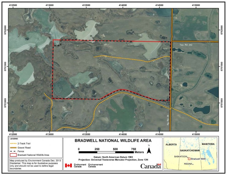
Long description for figure 1
Map showing the boundaries of Bradwell National Wildlife Area. A fence runs along most of the National Wildlife Area's perimeter. Regional road 24 runs along Bradwell's eastern edge and the intersection of regional road 24 and township road 342 occurs near the North Eastern corner. Several two track trails are shown on the map with one occurring in the National Wildlife Area. The scale on the map is in hundreds of meters. The inset on the map shows that Bradwell National Wildlife Area is located in Saskatchewan below Saskatoon and above Regina. Map produced by Environment Canada Dec. 2013. Disclaimer: This map is for illustrative purposes only and should not be used to define legal boundaries.
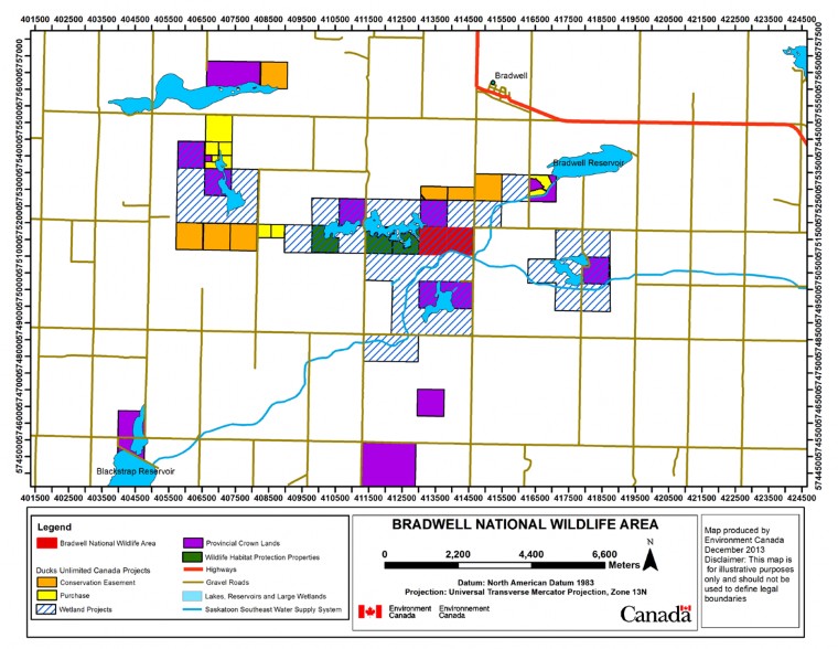
Long description for figure 2
Map showing the location of Bradwell National Wildlife Area with respect to other conservation lands. These include various Ducks Unlimited Canada Projects such as Conservation Easement, Purchase and Wetland Projects. The wetland projects both cover and surround the Bradwell National Wildlife Area. Also included are Provincial crown lands and wildlife habitat protection properties. The entire map is crisscrossed by gravel roads and the location of one highway is indicated in the North-Eastern corner. Blackstrap reservoir and Bradwell Reservoir are shown to be connected by the Saskatoon Southeast Water Supply System, which also runs off the map to the east. The map is in thousands of meters and was produced by Environment Canada December 2013. Disclaimer: this map is for illustrative purposes only and should not be used to define legal boundaries.
1.1 Regional context
Bradwell NWA is a 123-ha rectangular land parcel located in the Moist Mixed Grassland Ecoregion of Canada’s Prairie Ecozone, about 48 km southeast of Saskatoon, Saskatchewan (Figure 1). The regional climate is cool and subhumid, with more precipitation falling as rain during the warm summer, and relatively less precipitation falling as snow during the cold winter. Climate normals for nearby Saskatoon indicate mean annual precipitation is approximately 350 mm, while temperatures range from a mean July high of +25 ºC and a mean January low of -22 ºC (Environment Canada 2011a).
The landscape immediately surrounding and containing Bradwell NWA is an undulating glacio- fluvial outwash plain of sand and gravel. Natural wetlands are rare in this type of landscape because the soil is so rapidly drained, and instead it is more common for the abundant and mineral-rich groundwater to discharge into fewer but larger wetlands (Millar 1976, Stewart and Kantrud 1971). Elevations within the NWA are on average 532 m above sea level, with local relief up to 5 m that creates diversity in vegetation due to soil moisture. Deep-rooted shrubs in particular can more readily penetrate the coarse-textured soil and access groundwater, such that grassland vegetation should naturally include patches of shrubs or stands of trees in gentle depressions.
Agricultural land use and private land ownership dominate the region, leading to frequent changes in land cover and land use driven by changes in global demand and prices for commodities. As a result, many native species and natural processes that depend upon large and stable expanses of natural land cover (i.e., migratory bison herds or wild fire) are now missing from the ecosystem. Altering the landscape also alters local drainage and may have an impact on habitat in the NWA. Prior to cultivation, surrounding upland vegetation was mixed grass and fescue prairie (Coupland 1950, Coupland and Brayshaw 1953). Most of that vegetation and underlying dark-brown chernozemic soil was plowed and converted to cropland over the last century. Many wetlands were also drained or filled to further increase the area of cropland (Millar 1976, Bartzen et al. 2010).
The region is now fragmented by the grid road network that follows north-south and east-west road allowances every 1.6 to 3.2 km (McKercher and Wolfe 1978). This road network can interfere with wildlife and water movements, as well as facilitate movement of invasive alien species, pollutants, native predators, and parasites of wildlife (Forman et al. 2003). Surrounding agricultural activities include grain and oilseed annual crop production, perennial forage crop haying, and livestock grazing. Widespread use of pesticides and fertilizers and erosion of cultivated soils have affected local water and soil quality (Donald et al. 2007, Papiernik et al. 2005).
Despite these regional and landscape changes in land cover and land use, the wetland habitats continue to attract a diversity of wildlife. Eight species at risk and more than 100 species of migratory birds have been observed at Bradwell NWA or within its vicinity.
DUC has completed nearly 3,000 habitat projects in Saskatchewan, protecting 725,000 ha of wetlands and associated habitat through restoration and retention projects. The Baldwin Project is an initiative led by DUC in which the Bradwell NWA is embedded. DUC and CWS work together closely to protect and restore waterbird habitat in Bradwell NWA.
1.2 Historical background
Prior to European settlement, the surrounding region was occupied by First Nations of Plains Cree (Nahathaway), Assiniboine (Nakota), and Saulteaux (Anishnabe) background. Through most of the 1700s and 1800s, primary land uses were trapping for the fur trade or hunting and gathering for subsistence. During this period, the fur trade directly or indirectly caused great depletions in the populations of some wildlife, such as Beaver (Castor canadensis), Muskrat (Ondatra zibethicus), Bison (Bison bison), and Elk (Cervus elaphus). By the end of the 1800s, settlers began to arrive in the surrounding region, and founded many towns and villages along railways, like the village of Bradwell just 5 km north of the NWA (Fung 1999). From the early 1900s through to the 1970s, there was a rapid decline in natural land cover related to the increase in annual crop production. Wetlands in low-relief landscapes were sometimes filled during droughts or drained to increase the area of cropland (Bartzen et al. 2010). Only where the soil was too stony, saline, sandy, saturated, or steeply sloped did native grasslands and wetlands persist. Nearly all native grasslands have been grazed continuously by domestic livestock since the time of settlement.
Lands comprising Bradwell NWA were purchased from E.G. Baldwin in May of 1968, and construction of ditches, dykes and water control structures by DUC commenced soon afterward. The federal government purchased this land to establish Bradwell NWA at the request of DUC, which was interested in securing protected lands around the Baldwin Project. A formal agreement between the Government of Canada and DUC in March 1969 outlined the roles and responsibilities of the two agencies in regards to property access and liability for maintenance, operation, and reclamation of the infrastructure.
In the 1960s and 1970s, DUC only invested in water engineering structures, and thus encountered logistical challenges accessing structures across multiple private land holdings. Creation of Bradwell NWA in 1968 (officially in 1978) resolved this accessibility issue and increased the effectiveness of DUC’s Baldwin Project because it protected the water inlet structure off the main canal of the SSWSS and supported most of the engineered dykes, ditches, and dams that supply water to the Baldwin Project outside the boundaries of the NWA (Canadian Wildlife Service 1985). Until 1999, operations involved drawing water from the Saskatoon Southeast Water Supply canal in May of each year to fill basins to full supply level (FSL) throughout the Baldwin Project, followed by regular monitoring to allow a natural drawdown. Only in cases of drought was water drawn from the canal more frequently into mid-summer, or retained in ponds behind stop logs to extend the duration of water through the waterfowl brood rearing period (John Trevor, pers. comm.). A water licence from the Saskatchewan Water Security Agency (SWSA) allows removal of water from the canal, and that licence is held in the name of DUC. Under the terms of a formal agreement between the Government of Saskatchewan and DUC, all water licence fees are paid to SWSA by the Saskatchewan Ministry of Environment.
Today, DUC purchases or leases land and invests in conservation easements and improvements on private lands containing wetlands and uplands. As a result, much of the private property surrounding Bradwell NWA is functionally protected (Figure 2). Since 2000, DUC water management has changed, with less frequent monitoring of water levels and less manipulation of mid-summer water levels after the spring fill to FSL. DUC is increasingly pressured by downstream cattle producers to provide a continued flow through summer and fall for livestock watering purposes. DUC uses a limited number of wetland basins and ditches to provide water resources to downstream cattle producers and closes off other basins to allow natural drawdown (John Trevor, pers. comm.).
Approximately 46 ha of the 123-ha property were historically plowed and cultivated for annual crops. After acquisition of the property in 1968, barley lure crops were grown on cultivated lands until 1979 or 1983. In 1979, 22 ha were planted to four seed mixes as a demonstration and evaluation project to compare different native, tame, and legume mixtures for use as perennial nesting cover (Canadian Wildlife Service 1985). In 1983, a further 24 ha were planted to a mix of Smooth Brome (Bromus inermis), Tall Wheatgrass (Elymus elongatus), Intermediate Wheatgrass (Thinopyrum intermedium) and Alfalfa (Medicago sativa), based on the relative value of earlier plantings. Those seeded fields remained idle throughout most of 1983 to 2007. Lack of regular grazing, haying or burning of the vegetation permitted widespread seed dispersal and invasion of surrounding native grasslands by Smooth Brome, Alfalfa, Yellow Sweet Clover (Melilotus officinalis), Canada Thistle (Cirsium arvense), and Absinthe (Artemisia absinthium).
DUC staff repaired and replaced all metal water control structures between 2001 and 2012, and with each subsequent redisturbance of the soil the site has been revegetated. Seed mixes for revegetation include, in declining order of dominance, Intermediate and Tall Wheatgrass, Meadow Brome (Bromus biebersteinii), Green Needle Grass (Nasella viridula), Dahurian Wild Rye (Elymus dahuricus), Slender Wheatgrass (Elymus trachycaulus), Canada Wild Rye (Elymus canadensis), Creeping Red Fescue (Festuca rubra), and Alfalfa.
Active management of perennial vegetation with permitted domestic livestock at Bradwell NWA began in 2008. This agricultural activity has been beneficial to Bradwell NWA for three reasons. First, CWS benefits from having the eyes and ears of an agricultural permit holder to report any problems they may see in the NWA. Second, it provides revenue for reinvestment in fencing and signage that protects the property from prohibited activities. Third, and most importantly, decades of research in the surrounding region indicates that grasslands regularly grazed will provide more heterogeneity in nesting cover, thereby creating suitable habitat for a wider variety of birds (Fuhlendorf and Engle 2001). Thus, continued grazing will be an important tool to maintain ecological integrity of the Bradwell NWA.
1.3 Land ownership
Surface title to Bradwell NWA belongs to the Crown in Right of Canada. A total of 6.6 ha of the 129.6 ha in the complete half section on which Bradwell NWA is located were retained by the provincial government as canal and road rights-of-way. This includes an undeveloped municipal road allowance that crosses the northwest corner of the NWA. Road allowances are owned by Her Majesty in Right of Saskatchewan, but are managed by the local Rural Municipality of Blucher No. 343. Subsurface mineral rights for the Bradwell NWA are retained by Her Majesty in Right of Saskatchewan.
All surrounding lands are either provincial crown lands or privately held by livestock and annual crop producers, many with DUC leases or conservation easements (Figure 2). Livestock grazing is allowed on Bradwell NWA as a habitat management activity through permits under the Wildlife Area Regulations.
No utility rights-of-way occur on the land base or on legal land titles.
1.4 Facilities and infrastructure
No facilities are present on site (Table 2). Signs and fences are maintained by CWS through periodic field checks along the boundaries. The wood post and barbed wire perimeter fence around the NWA is 3 miles (4.8 km) in length. Fence condition across wetland areas has deteriorated, while fences on uplands could be classified as fair.
The water control infrastructure built, maintained, and operated by DUC has been repaired and replaced over the 45 years since the project began. As of 2012, the project and works were in good condition, with four of five culverts replaced in 2001 and one replaced in 2012. A concrete cairn with a brass plaque depicting and explaining the Baldwin Project was placed by DUC at a south-central location on the NWA (Figure 3) and is maintained by DUC.
| Type of facility or infrastructure | Approximate size | Responsibility holder or owner |
|---|---|---|
| Wood post and wire fence | 4,480 m | CWS |
| Boundary signs (~9) | n/a | CWS |
| Entry/information sign (2) | n/a | CWS |
| Dedication cairn | 1 m2 | DUC |
| Dam and culvert, each 60 m2(5) | 300 m2 | DUC |
| Earthen dyke 500 m long (1) | 1,000 m2 | DUC |
| Ditches 1200 m long x 10 m wide (4) | 12,000 m2 | DUC |
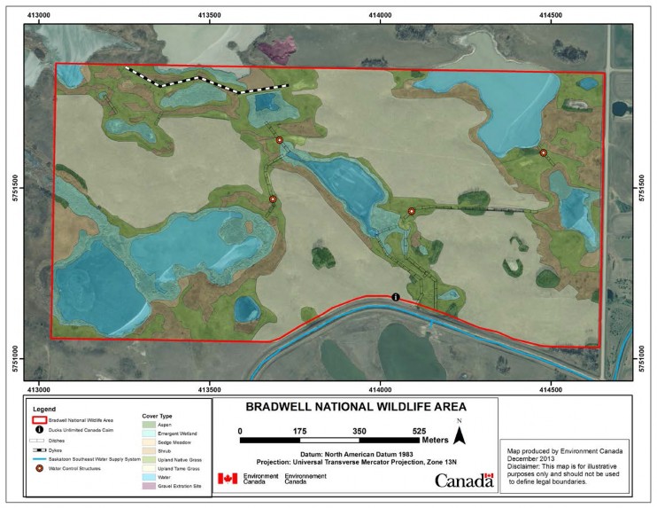
Long description for figure 3
Map showing the boundaries of Bradwell National Wildlife Area and the cover types contained within. The cover types shown are aspen, emergent wetland, sedge meadow, shrub, upland native grass, upland tame grass, water and gravel extraction site. A dyke is located in the Northwestern quarter of the National Wildlife Area. A Ducks Unlimited Canada Cairn is located on the southern boundary. Ditches are shown throughout the National Wildlife Area and four water control structures are indicated. The Saskatoon Southeast water supply system runs along the Eastern half of the Southern boundary of the National Wildlife Area. A gravel extraction site is located outside of the Wildlife Area near the Northern boundary. The map is in hundreds of meters and produced by Environment Canada December 2013. Disclaimer: this map is for illustrative purposes only and should not be used to define legal boundaries.