
John Lusby Marsh National Wildlife Area Management Plan, 2016: chapter 1
1 Description of the Protected Area
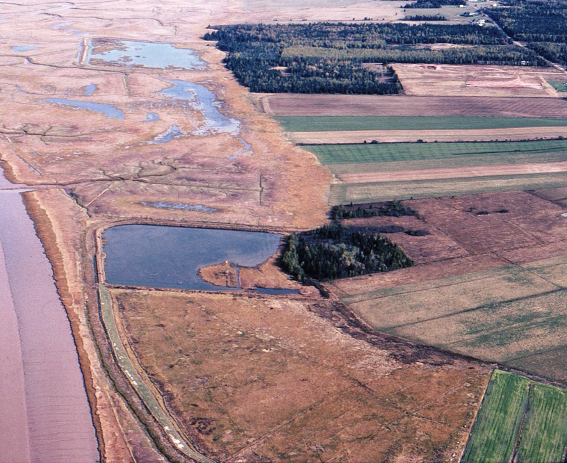
John Lusby Marsh National Wildlife Area (NWA) (45°49′N, 64°15′W) is located 1 km west of the town of Amherst, Cumberland County, Nova Scotia, and lies along the foot of the north slope of the Amherst Point Ridge (Figure 1 and Figure 2). The wetlands of this 600 ha NWA border the crescent-shaped southern shore of Cumberland Basin for over 5 km. The NWA consists almost entirely of salt marsh with the exception of two small, controlled water level brackish impoundments adjacent to the uplands.
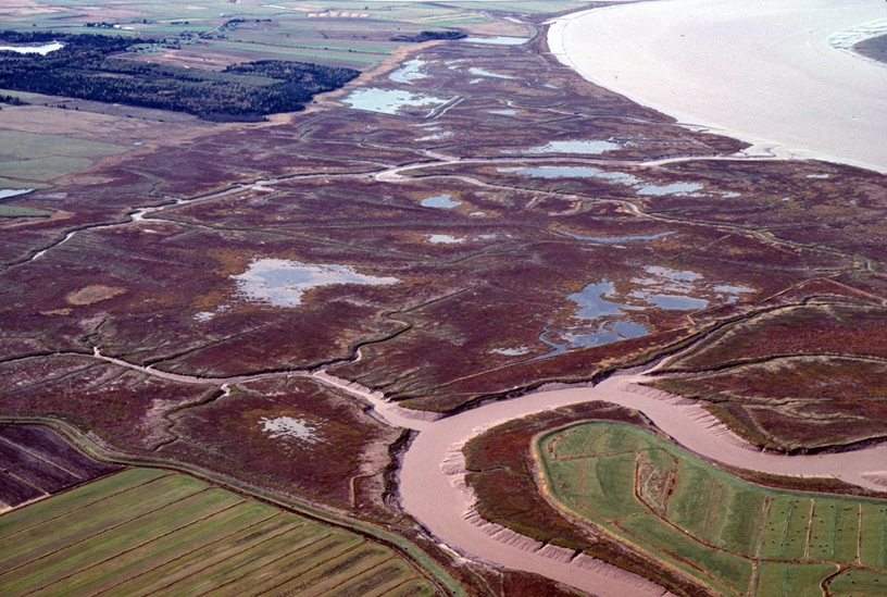
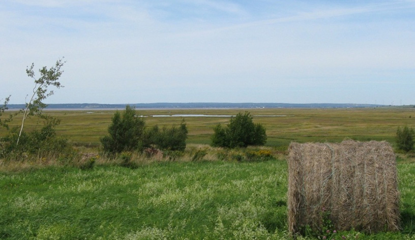
From a distance, the wetland at John Lusby Marsh NWA appears to be a uniform expanse of low-lying vegetation (Figure 3). This perception masks the hidden diversity that is driven by variations in the water levels across the marsh. As a macro-tidal system, the upper Bay of Fundy has an average tidal range of 11 m (Gordon et al. 1985). The difference of a few centimetres in tide levels, combined with periods of tidal inundation, salinity and soil drainage, can result in a markedly different association of plants (Desplanque and Mossman 2004). While generally the channels flooded daily by the tides are dominated by the cord grass Spartina alterniflora, higher regions of the marsh may also support a greater diversity of halophytes such as Spartina patens and Puccinellia maritime, with occasional interspersions of Limonium nashii. Those areas less influenced by the tides contain the grasses Hordeum jubatum, Hordeum vulgare with Spartina pectinata, and Solidago sempervirens on or above the higher high-water mark (Flanary and Chmura 2007).
John Lusby Marsh NWA is recognized as an important breeding, staging and migration area for waterfowl and shorebirds (Van Zoost 1970; Hall and Jones 1971; Hall 1972; MacKinnon et al. 1985; Hanson 2004). This NWA is an International Union for Conservation of Nature Category IV protected area and, in association with the nearby Chignecto NWA, is recognized as a wetland of international importance under the Ramsar convention of 1971.
| Category | Information |
|---|---|
| Protected area designation | National Wildlife Area |
| Province or territory | Nova Scotia |
| Latitude and longitude | 45°49'N, 64°15'W |
| Size (ha) | 600 ha |
| Protected area designation criteria | Historic: Protecting an area with concentrations of birds. Current: Criteria 1(a), where "the area supports a population of a species or subspecies or a group of species that is concentrated for any portion of the year". The area also satisfies criteria 2(b), where "the area has special value for maintaining the genetic and ecological diversity of a region because of the quality and uniqueness of its fauna and flora". |
| Protected area classification system | Site is important for species and habitat conservation (Environment Canada 2005) |
| International Union for Conservation of Nature (IUCN) classification | IV |
| Order in council number | PC 1978-1439 |
| Directory of Federal Real Property (DFRP) number | DFRP number 3197 |
| Gazetted | 27 April 1978 |
| Additional designations | Designated as a Ramsar site on 16 October 1985. |
| Faunistic and floristic importance | Largest single tract of salt marsh in the Bay of Fundy. Important habitat for migrating waterfowl and shorebirds. |
| Invasive species | None recorded. |
| Species at risk | Peregrine Falcon (Falco peregrinus) breeds in the vicinity, and the marshes are used as foraging area. |
| Management agency | Canadian Wildlife Service |
| Public access and use | Waterfowl hunting is allowed. The area has been the focus of numerous salt marsh and sea-level rise studies. |
| Other appropriate information | The site is predominantly tidal and intertidal salt marsh. |
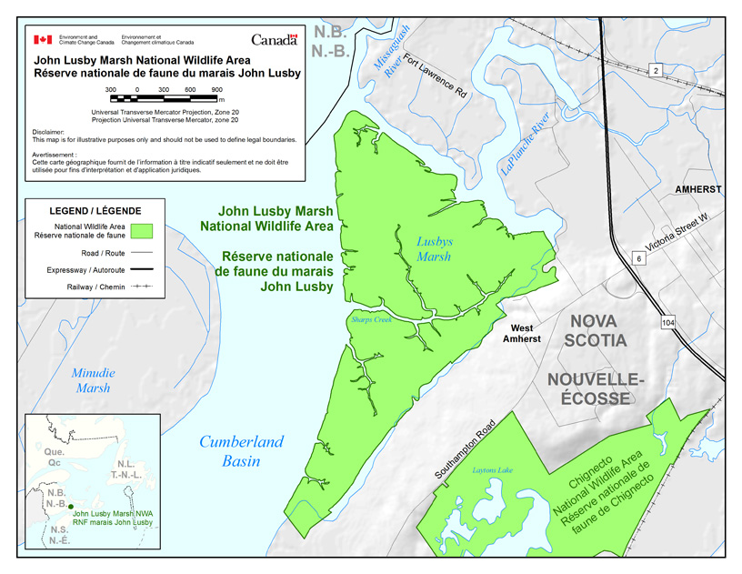
Long description for figure 1
Map showing the boundary of John Lusby Marsh NWA, located in Nova Scotia, close to the border with New Brunswick. The wildlife area forms a triangle located between the eastern shore of the Cumberland Basin, the southern shore of the LaPlanche River and north-west of Chignecto NWA. The map shows one main stream running through the wildlife area named Sharps Creek. Two communities are shown on the map, Amherst and West Amherst, as well as a few roads, Expressway 104, Road 2 and Road 6. The inset map shows the location of John Lusby Marsh NWA in the western central area of Nova Scotia, relative to New Brunswick, Newfoundland and Quebec. The scale is in meters and the Universal Transverse Mercator Projection is Zone 20. Disclaimer: This map is for illustrative purposes only and should not be used to define legal boundaries. National wildlife areas, roads, expressways and railways are indicated on the map.
1.1 Regional context
John Lusby Marsh NWA is situated in Cumberland County, Nova Scotia, 1 km west of the town of Amherst. The NWA is bordered to the west by the gentle curve of Cumberland Basin, La Planche Marsh is to the northeast and Amherst Point Ridge to the southeast.
The underlying geology consists of sedimentary formations laid down during the Carboniferous and Permian periods over 300 million years ago (Roland 1982). The marshes were formed by tidal erosion of ancient sedimentary sandstone deposited over thousands of years from the silt-laden waters of the bay. Besides the gypsum beds underlying west Amherst, there are also extensive subsurface salt deposits that are commercially extracted south of the NWA.
This region at the head of the Bay of Fundy is known as the Chignecto Isthmus, an area famous for its flat, prairie-like agricultural dykelands. This narrow stretch of land separates the Bay of Fundy to the west and Baie Verte, part of the Northumberland Strait, to the east. Except for the nearby Shepody marshes to the west and Grand Pre dykelands in Minas Basin to the south, this region is unique in the Atlantic provinces. Before the arrival of European settlers, the John Lusby Marsh NWA, together with the Tantramar, Missaguash, Nappan and LaPlanche dykelands, was part of a larger association of wetlands at the head of the Bay of Fundy. These wetlands comprised a rich mosaic of lakes, bogs, fens and salt marshes (Ganong 1903; Hanson and Calkins 1996). Intensive land use over the past 300 years, predominantly for agriculture, has resulted in the dyking, ditching and draining of much of this land. John Lusby Marsh NWA is one of only a few areas that have reverted back to salt marsh habitat (Hustvedt 1987) (Figure 3).
John Lusby Marsh NWA is situated within the Atlantic Maritime Ecozone. One of 15 terrestrial ecozones in Canada, the Atlantic Maritime Ecozone includes all of New Brunswick, Prince Edward Island, Nova Scotia and Quebec's Gaspé Peninsula. Within this ecozone, the NWA is situated within the Fundy Coast Ecoregion (123) and the Chignecto-Minas Shore Ecodistrict (507) (Figure 5) (Webb and Marshall 1999).
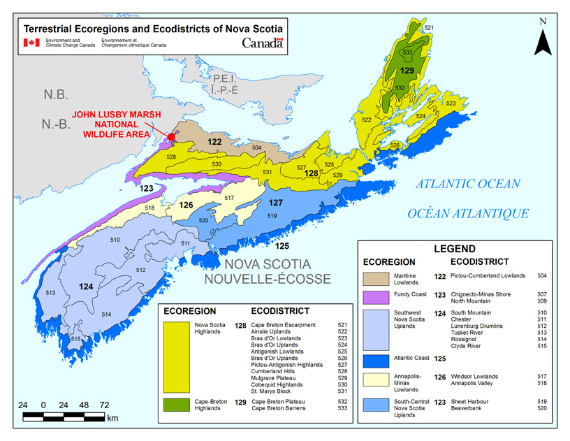
Long description for figure 5
Illustration showing the terrestrial ecoregions and ecodistricts of Nova Scotia and the location of John Lusby Marsh National Wildlife Area. Eight ecoregions are shown, with John Lusby Marsh NWA being located within Ecoregion No. 123, Fundy Coast. 26 ecodistricts are shown, with John Lusby Marsh MWA being located within Ecodistrict No. 507, Chignecto-Minas Shore, in the western central area of the province. The scale on the map is in km. The legend shows all terrestrial ecoregions and ecodistricts present in Nova Scotia.
1.2 Historical background
The early 18th-century Acadian settlement on Amherst Point Ridge was known as "Wehekage," a word presumably derived from an Aboriginal name for the area, although the actual meaning is now lost. The entire Chignecto Isthmus was likely important to the area's Aboriginal peoples. Some of the earliest archaeological sites bordering Cumberland Basin date back nearly 4000 years (MacKinnon 2003a and 2003b). The abundance of waterfowl on the expansive marshes and fish stocks in nearby rivers would likely have made this an attractive hunting area.
By the later 1600s, French Acadian settlers from the village of Beaubassin on the Fort Lawrence Ridge radiated outward to numerous sites bordering the Chignecto Isthmus. Much Acadian farming was centred on the dyking and draining of salt marshes using one-way sluice gates known as aboiteau. The wetlands around Amherst Point, including the John Lusby Marsh NWA, were a logical focal point for this activity. It is unknown how much of the John Lusby Marsh NWA was dyked during the Acadian period, although the area was likely considerable based on contemporary maps. Following the Acadian deportation of 1755, New England planters settled the region. Amherst was one of three townships established in the 1760s on the Chignecto Isthmus. Many farms were scattered along the west Amherst Point Ridge by the mid-19th century, and descendants of many of those settlers reside there today (Figure 6).
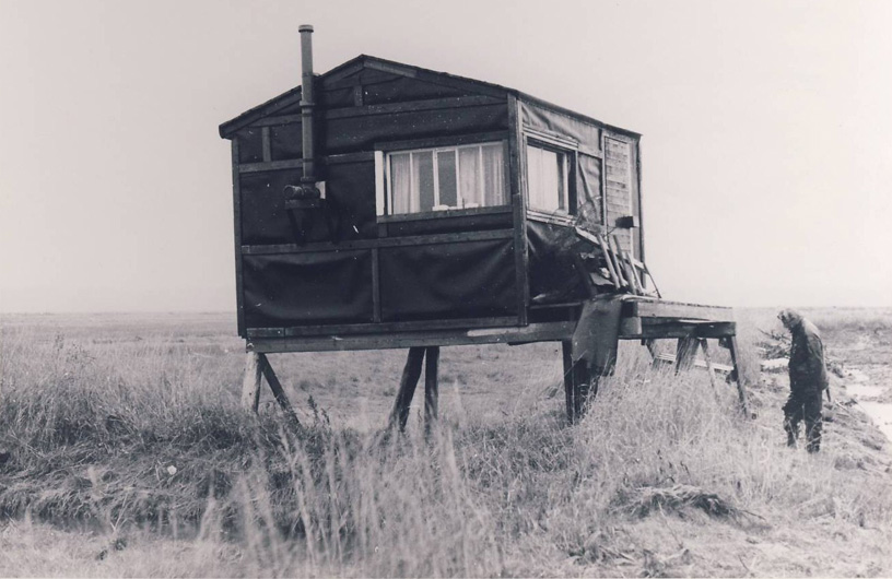
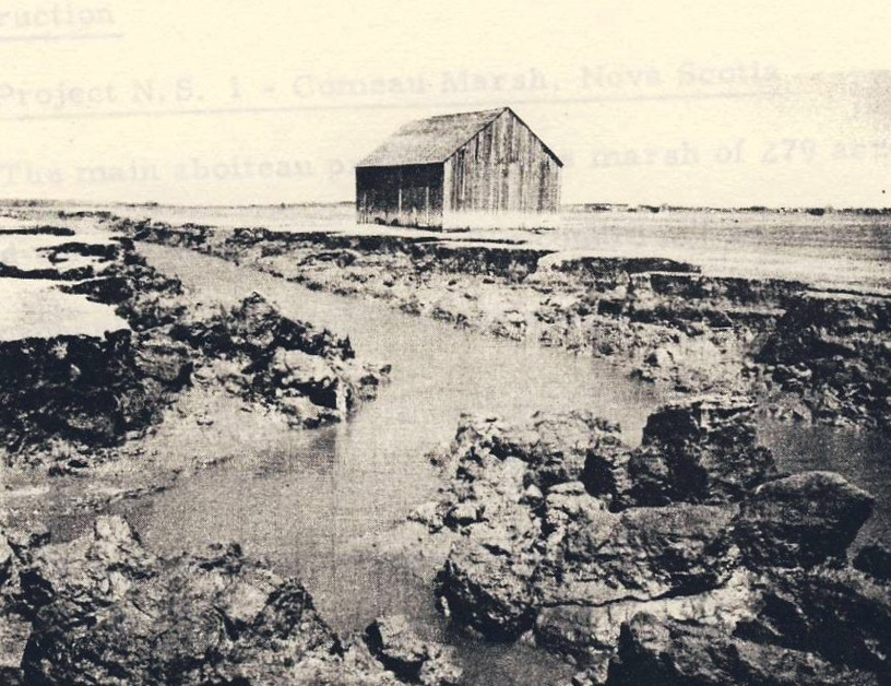
The marsh lands were traditionally divided into lots associated with upland farms, and by the end of the 18th century much of the area at John Lusby Marsh NWA was probably dyked and drained. The John Lusby Marsh NWA is bisected east to west by Sharpe's Creek, a large tidal creek that runs through the centre of the NWA (Figure 1). The dykelands were managed as two marsh bodies protected within one dyke complex: the Embree Marsh Body to the north of the creek and the nearly equally sized McGowan Body of lowlands to the south. This intensive dykeland agriculture continued into the 20th century, until external factors including the Great Depression, followed by the Second World War, made dyke maintenance on some marshes no longer economically feasible. As the dykes deteriorated, storms and tidal action did a considerable amount of damage to this abandoned infrastructure. In a few short years, marsh roads were either buried in sediment or eroded away. Most buildings, including possibly as many as 32 marsh barns, were quickly lost to this assault (Figure 7). Hay was last cut on the site of John Lusby Marsh NWA in a limited amount in 1947.
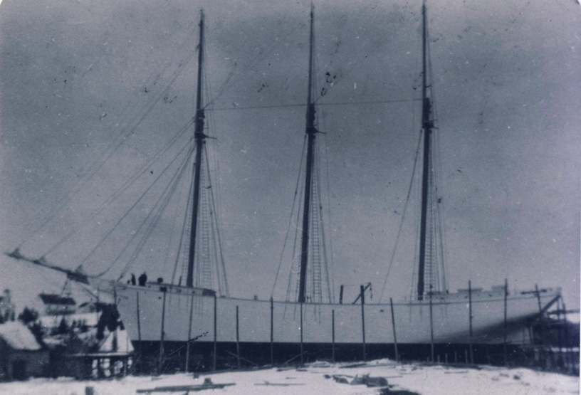
The marsh was also the site of a short-lived shipping port where a small log and rock wharf was connected to the uplands by a rail line. This short railroad spur connected the Amherst Point gypsum quarry to its terminus at the shore (Figure 8). This wharf operated primarily during the early 1900s and was frequented by small sailing vessels such as the three-masted schooner "Phoenix." Remnants of this later-abandoned rail bed form part of the public walking trail within the nearby Chignecto NWA.
In 1966, the Canadian Wildlife Service recognized the significance of the marsh for waterfowl and proposed its protection (Watson 1965). In honour of the site's past history, this new NWA on the Amherst Marsh was named after Mr. John Starr Lusby (1868-1947), a prominent local farmer and historian. The Appendix I provides a brief account of his life.
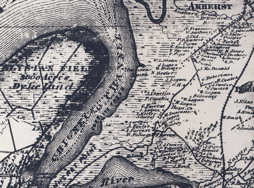
Long description for figure 6
19th-century historical map showing uplands adjacent to the John Lusby Marsh NWA, east of the Chignecto Channel and south of Amherst. Names of land owners are indicated on the map.
1.3 Land ownership
The entire John Lusby Marsh NWA is owned and administered by the Government of Canada. The property boundary generally follows the shore of Cumberland Basin to the north, the mid-channel of the La Planche River to the east, and the toe of the upland to the south (Figure 1). Included along this upland fringe are a small (less than 1 ha) strip of upland adjacent to the Russell Impoundment and a larger (2.8 ha) block of wooded upland adjacent to the Burgess Impoundment.
The federal government does not hold the sub-surface mineral rights for John Lusby Marsh NWA (Fisher and Wenning 2009).
1.4 Facilities and infrastructure
There are no roads, trails or buildings within the John Lusby Marsh NWA. Maintenance requirements are predominantly directed towards boundary signage and impoundment management. Annual visits include boundary inspections and repairs and replacement of the regulatory signs (Tables 2 and 3). Impoundment infrastructure management is conducted in collaboration with Ducks Unlimited Canada (Figure 9).
| Type of facility or infrastructure | Approximate size or number | Responsibility holder or owner |
|---|---|---|
| Property boundary | 12.1 km | Environment and Climate Change Canada's Canadian Wildlife Service (ECCC-CWS) |
| Boundary signs | 100 | ECCC-CWS |
| Public notice signs | 4 | ECCC-CWS |
| Entrance signs | 1 | ECCC-CWS |
| Access right-of-way | 2 | ECCC-CWS (in part) |
| Impoundments | 2 | Ducks Unlimited Canada (DUC) |
| DUC project name | DUC project number | CWS project name | Year built | Size (ha) |
|---|---|---|---|---|
| Amherst Point 1 | 6113 | Russell Impoundment | 1982 | 7 |
| John Lusby 1 | 6112 | Burgess Impoundment | 1982 | 13 |
1.5 Socio-economic assessment
Although no specific socio-economic studies have been conducted regarding this NWA, more general surveys have highlighted the value that the Canadian public places on habitat set aside for wildlife (Environment Canada 1991).
It is noteworthy that the dykes protecting the former hay lands of the John Lusby Marsh NWA have been breached for more than 60 years. When hay was in high demand in the late 19th and 20th centuries, these agricultural lands would have been of high value to local farmers. As the demand for hay declined, many dykelands were not economically feasible to maintain, and the dykes were allowed to deteriorate and were eventually destroyed by high tides and storms. In the early 1950s, area landowners and officials of the Maritime Marshland Rehabilitation Administration, which then administered the dykelands, deemed the dykes and aboiteau too costly to rebuild and made the decision to allow the site to revert back to salt marsh (Hustvedt 1987; Papadopoulus 1995).