
Portage Island National Wildlife Area Management Plan: appendix 1
Appendix I: History of Portage Island National Wildlife Area
The Portage Island region has been the home of the Mi’kmaq people for generations. The nearby First Nation community of Esgenoôpetitj (Burnt Church) has a long settlement history. Metepenagiag (formerly Red Bank First Nation) on the Miramichi River has over 3000 years of continuous settlement, making it the oldest village in New Brunswick ( Allen 1994 ).
When French fishermen first arrived at the mouth of the Miramichi River, the Mi’kmaq called the largest island in the Miramichi Bay "Molaweeswayadik" (meaning the place of occurrence of Brant Geese) ( Mitcham 1986 ). It is assumed that the present name of Portage Island refers to the fact that Aboriginal people and early French settlers often stopped at the island when crossing the bay ( Smethurst 1774 ). According to Perley (1852), Portage Island was the site of the first year-round trading and fishing settlement to be established on Miramichi Bay. From 1643 to 1647, Jean Jacques Enaud, a native of the Basque provinces of France, had an establishment on this island for taking the "Morse" or Walrus (Odobenus rosmarus), and for exploiting the fur trade and fisheries. The Walrus was annihilated on Portage Island partly due to Enaud’s efforts.
Throughout the early 1800s, lobster fishing quickly developed as a supplement to the local economy. A small lobster processing facility was established on Portage Island, although the actual location of this facility is unknown, and the site may have since eroded away. Perley, writing on the state of the New Brunswick fishery in 1852, provides the following details:
On the northern side of Miramichi Bay, at the entrance of the Miramichi River, is Portage Island, which on some of the older maps is called Waltham Island. It is about four miles and a half in length, and nearly a mile in width at its southwestern end, tapering gradually to its northeastern extremity, where it terminates in a long narrow sand-bar.
This Island is yet ungranted. It is low and sandy, much cut up with marshes, swamps and small lakes; a portion of it only is wooded, with dwarf white birch, and scrubby pine and spruce trees.
Near the northeastern end of Portage Island, some buildings were erected about five years ago, with the necessary conveniences for putting up salmon and lobsters, in tin cases hermetically sealed. This station was occupied during the season of 1849, by Mr. William J. Fraser, of Chatham, who then for the first time set up "fish flakes," and undertook to dry and cure cod, and other fish, caught near this locality.
When this establishment was visited in August last, it was in charge of George Letson, who furnished the following information in relation to it.
The season for putting up salmon and lobsters was over. There had been twenty two thousand pounds of salmon, and four thousand pounds of lobsters, put up in tin cases, of one pound and two pounds each. The quantity of lobsters put up was much less than usual, owing to the prevalence of cholera in the United States, and the consequent want of a market there.
The salmon put up here were all taken around the Island, and were purchased of the fishermen, by this establishment, at 3d. per pound, fresh caught, with a discount of ten per cent, for cleaning, which was said to be equal to £3 5s. per barrel. The lobsters were chiefly caught by the French inhabitants of the neighbouring Neguac Villages, from whom they were purchased at 2s. 6d. currency, per hundred. They were very plentiful the past season, especially at Black Lands and Tabusintac Gully; and as proof of the ease with which they were taken, it was mentioned that one Frenchman (Victor Savoy) had, unassisted, caught 1200 lobsters in part of one day. There were from twenty to twenty five men employed at the preserving establishment during the season.
Up to the 18th August, there had been seven hundred quintals of cod, ling, and haddock, caught and cured at this "room" to which a considerable addition was anticipated before the close of the season. There were then thirty three boats engaged in fishing at this station, averaging three men to each boat; these were chiefly settlers from the neighbouring shores, who employed the period between seed time and harvest, in following the fisheries. ( Perley 1852, pages 28-29 )
And further,
Within a few years, one establishment has been set up on Portage Island, at the month of the Miramichi River, and another at the mouth of the Kouchibouguac River, for putting up lobsters, in tin cases, hermetically sealed, for exportation. In 1845, no less than 13,000 cases of lobsters and salmon were thus put up at Portage Island. In 1847, nearly 10,000 cases, of lobsters only, each case containing the choicest parts of two or three lobsters, and one and a half tons of fresh salmon, in 2 lb. and 4 lb. cases, were put up at Kouchibouguac. The preservation of lobsters, in this manner, need only be restricted by the demand, for the supply is almost unlimited. The price paid for lobsters at the establishment on Portage
Island, when the writer visited it, was 2s. 6d. currency (2s. sterling) per hundred. ( Perley 1852, pages 20-21 )
In 1867, the island was divided into 31 "meadow lots" set aside primarily for harvesting native dune grasses for livestock forage to be used by farmers and fishermen on the mainland (Figure 12). In that year, the proprietors harvested a total of 8.8 tons of hay at an annual rent to the Crown of £5. 10. 0. Of botanical interest, the island was described as being mainly "course grass very thin," with a narrow band of "woods" along the southern border of Gammon Cove and a "strip of small white birch" along the eastern side of this same cove. Two small areas are delineated as "Sand Hill" and "Wet Bog." There are also three narrow, ribbon-shaped ponds, with the southernmost referred to as "Horn’s Brook."
With all this activity in Miramichi Bay, it is no surprise that shipping interests wanted to take measures to ensure the safe movement of goods. In 1869, a lighthouse was established on Portage Island to mark the northern half of the main entrance to Miramichi Bay (Figure 13). At least eight lighthouse keepers, often with families, were resident on the island from 1869 to 1960 (Table 9). The lighthouse was eventually decommissioned and moved to the New Brunswick Aquarium and Marine Centre in Shippegan for preservation (Figure 14). Range lights are still maintained by the Canadian Coast Guard (Figure 15).
| Year | Lighthouse keeper |
|---|---|
| 1869-1875 | George Davidson |
| 1875-1881 | Hugh Murray |
| 1881 | Duncan Robertson |
| 1881-1892 | James Stymest |
| 1892-1924 | Peter Morrison, Jr. |
| 1925-at least 1930 | J.W. Gratton |
| 1930s | Thomas LeBreton |
| 1960 | Venance Savoy |
Where Portage Island provided close access to fishing grounds, it was also remote from the coastal communities and isolated in winter months. The island’s dunes were never suitable for farming, and no permanent settlements were ever established. It is uncertain when the fishery outlined by Perley ended operations. However, similar enterprises along the coast terminated in the late 19th and early 20th centuries.
In 1970, the Canadian Coast Guard automated the lighthouse, and keepers were no longer required. The island was declared surplus by the federal Department of Transport, and the Canadian Wildlife Service applied for transfer of the lands. Portage Island was formally transferred on November 3, 1970, by Order in Council P.C. 1970-1932.
A formal archaeological survey of Portage Island has not been conducted, but areas that require further investigation have been identified. Significant but as yet unidentified sites may exist on Portage Island in light of the area’s history, although the shifting sands and constant erosion on the island make the survival of very early archaeological resources difficult. Locations of sites worthy of further investigation are identified in Figure 11 ( MacKinnon 1991 ). These are:
- Excavations or basements - a series of pits of unknown purpose, averaging 3 m by 3 m in size. These may be related to the fishing activities outlined by Perley (1852).
- Excavation - a pit 4 m by 4 m in size, located approximately 50 m from the beach. A Jack Pine growing out of the pit was aged to 53 years. Erosion has now destroyed this site.
- Dyke - a low ridge, 40-50 m long with a break in the middle, connects two of the vegetated dunes along the northwest coast of the island at Gammon Bay. The break in the dyke may have been the location of an aboiteau. The dyke connects with the old foot trail that crosses the island. This feature is associated with Lot 14 assigned to Samuel Breau, as marked on the map of "Meadow Lots" dated 19 September 1867 (Figure 12).
- Shallow depression (1 m by 2 m) situated on a ridge east of the dyke, of unknown purpose.
- Ancient "foot trail" leading from Gammon Cove to the east side of Portage Island (Figure 16).
- Lighthouse dwelling - basement and foundation remnants (Figures 13 and 14).
Other sites of significance will be documented on future trips, and these finds will be reported to the Provincial Archaeologist, Archaeological Services, Fredericton, New Brunswick.

Map: © Environment Canada, 2014
Long description for Figure 11
Figure 11. A historical map of Portage Island National Wildlife Area with locations of numbered features 1 to 5 as described in the text above. The scale of the map is in hundreds of meters. Further details can be found in the preceding/next paragraph(s).Long Description Insert Here. Further details can be found in the preceding/next paragraph(s).
Photo: © Public Works and Government Services Canada, 1867
Long description for Figure 12
A hand drawn, historical map of a portion of Portage Island with dykes and lot numbers hand written on the map. Further details can be found in the preceding/next paragraph(s).
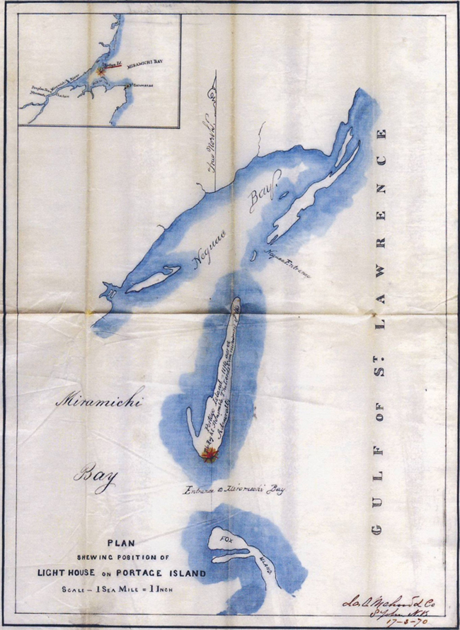
Photo: © Public Works and Government Services Canada, 1870
Long description for Figure 13
Figure 13. A historical map of Portage Island, Neguac Bay and Fox Island in Miramichi Bay, with a star at the south end of Portage Island indicating the position of the lighthouse. Map scale is 1 nautical mile to 1 inch. Inset map indicates the position of Portage Island relative to the coast of New Brunswick. Further details can be found in the preceding/next paragraph(s).
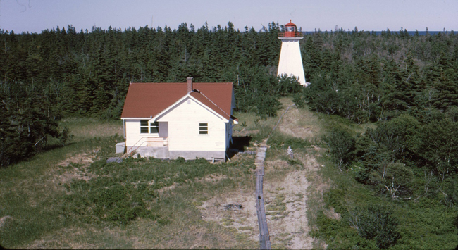
Photo: A.D. Smith © Environment Canada, 1971
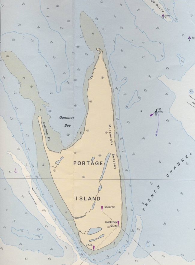
Photo: Canadian Hydrographic Service © Minister of Fisheries and Oceans Canada, 1993
Long description for Figure 15
Figure 15. A nautical chart (map) of Portage Island with surrounding water depths in metres and the position of 3 range lights at the south end of the island. Further details can be found in the preceding/next paragraph(s).
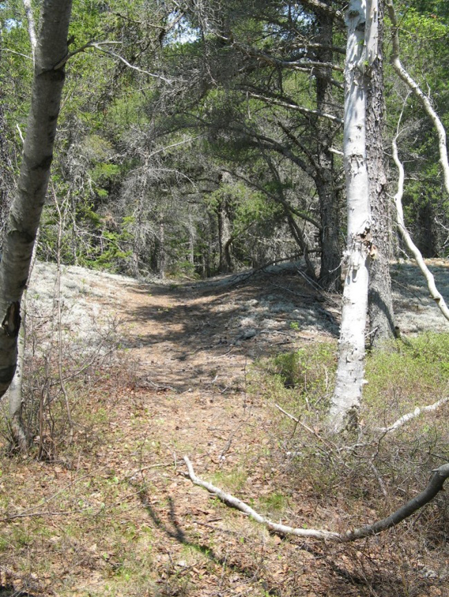
Photo: C. MacKinnon © Environment Canada, 2014