
Portage Island National Wildlife Area Management Plan: chapter 1
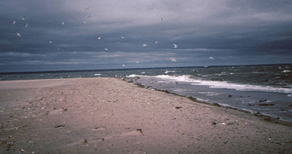
Photo: C. MacKinnon © Environment Canada, 1991
1 Description of the Protected area
Portage Island National Wildlife Area (NWA) is an island in Miramichi Bay at the mouth of the Miramichi River (Figure 2), New Brunswick (47°10’N, 65°02’W). The 348-ha island, measuring 5.7 km long by 1.15 km wide, comprises a variety of habitat types: 41% forest habitat, 25% unvegetated dunes, 12% salt marsh, 10% shrub-dominated (Myrica sp.) dunes, 9% grass-dominated (Ammophila sp.) dunes and 3% brackish ponds (Figure 3).
Portage Island NWA is an International Union for Conservation of Nature Category 1a protected area. This NWA is an important staging and migration area for waterfowl and supports a diversity of migrating shorebirds. A significant number of endangered Piping Plovers (Charadrius melodus) nest on the island ( five nests recorded in 2003 ). Large numbers of Red-breasted Mergansers (Mergus serrator) and non-breeding Double-crested Cormorants (Phalacrocorax auritus) are also found here during the summer months ( Barkhouse and Smith 1981; MacKinnon 1991 ).
Portage Island was declared an NWA on November 8, 1979. The NWA is administered under the Wildlife Area Regulations of the Canada Wildlife Act and is managed by the Canadian Wildlife Service of Environment Canada.
| Category | Information |
| Protected area designation | National Wildlife Area |
| Province or territory | New Brunswick |
| Latitude and longitude | 47°10’N, 65°02’W |
| Size | 451 ha (1114 acres) (Note: In 2000, due to erosion, the island size was 348 ha (860 acres)) |
| Protected Area Designation Criteria (Protected Areas Manual) | Historic: Note: Supports a population of a species or subspecies or a group of species which is concentrated, for any portion of the year. Specifically, Portage Island NWA supports concentrated populations of waterfowl and shorebirds, including 1% of the breeding population of Piping Plovers in the Atlantic Region. Current: Meets criteria 1(a), where “the area supports a population of a species or subspecies or a group of species which is concentrated, for any portion of the year. "Specifically, colonial species such as Double-crested Cormorant and Great Blue Heron utilize the wetlands on Portage Island NWA and are therefore concentrated on the island for a portion of the year. The area also satisfies criteria 2(b), where “the area has special value for maintaining the genetic and ecological diversity of a region because of the quality and uniqueness of its flora and fauna." |
| Protected Area Classification System | Species or Critical Habitat Conservation |
| International Union for Conservation of Nature (IUCN) Classification | 1a |
| Order-in-Council number | PC 1970-1932 and PC 1979-3017 |
| Directory of Federal Real Property (DFRP) number | 04618 |
| Gazetted | November 8, 1979 |
| Additional designations |
|
| Faunistic and floristic importance | Unique sequence of coastal dune succession |
| Invasive species | None documented |
| Species at risk | Piping Plover |
| Management agency | Environment Canada, Canadian Wildlife Service |
| Public access and use | Public access is allowed. Beaches, accessible by boat, are frequently used for summer recreation. No visitor infrastructure exists within the NWA. |

Photo: © Environment Canada, 2014
Long description for Figure 2
Figure 2. A map of the location of Portage Island National Wildlife Area within New Brunswick, showing nearby features such as Miramichi Bay, Neguac Provincial Park, and the towns of Neguac, Lower Neguac, Burnt Church and roads on the mainland. Map scale is in kilometres. Further details can be found in the preceding/next paragraph(s).
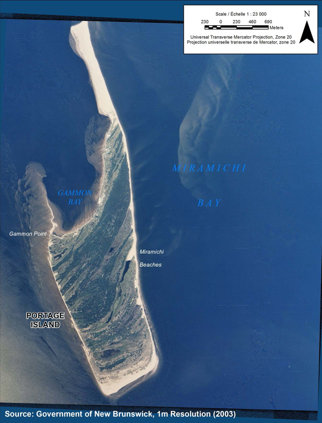
Photo: © Environment Canada, 2003
Long description for Figure 3
Figure 3. An aerial (satellite) photo of Portage Island in 2003 within Miramichi Bay showing features of Gammon Bay, Gammon Point, and Miramichi Beaches. Map scale is in hundreds of metres. Source: Government of New Brunswick 2003. Further details can be found in the preceding/next paragraph(s).
1.1 Regional context
Portage Island NWA is located in Miramichi Bay, 39 km northeast of Miramichi City, Northumberland County, New Brunswick (47°10’N, 65°02’W) and 6 km from the mainland. The mainland communities west of Portage Island, i.e., Neguac and Burnt Church (Esgenoôpetitj) First Nation, have a long history of human use of Portage Island associated with the coastal fishery ( Perley 1852; Ganong 1904 ). The usual boat launching point to access Portage Island is situated at Hay Island Provincial Park, 3.7 km northwest of the island (Figure 2).
Portage Island lies within the Atlantic Maritime ecozone, one of 15 terrestrial ecozones in Canada. Within this ecozone, the island is situated within the southeastern coastal extremity of the Caraquet ecodistrict ( Zelazny 2007 ). This ecodistrict follows the coastal rim of New Brunswick’s Acadian Peninsula, which begins at the mouth of the Miramichi River (site of Portage Island NWA) and ends at the mouth of the Nepisiguit River. The eastern arm of this ecodistrict, from Caraquet Island to Bartibog Bridge, consists of a series of sand dunes, protected bays and barrier islands. Portage Island is the most southern and removed of this linear chain of coastal habitat.
Portage Island is part of a series of coastal dunes and islands that border the east coast of New Brunswick ( McCann 1980; O’Carroll et al. 2006 ). To the immediate south of Portage Island lie Fox Island and Huckleberry Island, and to the southeast lie Bay du Vin Island and Egg Island. Another dune system, Neguac Bar, lies north of Portage Island.
This area is important to a variety of waterbirds. Bay du Vin Island supports a colony of Great Blue Herons, with 229 nests recorded in 1993, making it the largest colony in the province at that time ( MacKinnon 1993a ). A small isolated islet off the southern tip of Huckleberry Island also once supported a large colony of Common Terns. Egg Island has a colony of Double-crested Cormorants ( MacKinnon 1996 ). Neguac Bar once supported a significant Common Tern colony, with 3527 nests recorded in 1993. This colony was abandoned around 1994 due to human disturbance ( MacKinnon 1993b ). As bird colonies shift and relocate, Portage Island NWA may provide important undisturbed habitat for these species ( Boyne and Hudson 2002; Davis et al. 2011 ).
This entire network of coastal islands, including Portage Island, provides important habitat for the endangered Piping Plover ( Environment Canada 2012 ). The Piping Plover’s nesting habitat of exposed dune flats and areas of "wash-over" and "blow outs" make nesting precarious, as these sites are highly susceptible to flooding from high tides and storms ( Goodale et al. 2007; Cohen et al. 2009 ). Portage Island provides both a large area and a diversity of coastal habitat that is important for this species.
1.2 Historical background
This region has been the home of the Mi’kmaq people for generations. The nearby First Nation community of Eskinuopitijk, also known by the English name of Burnt Church, has a long history of settlement. Metepenagiag, located on the Miramichi River, has over 3000 years of continuous settlement, making it the oldest village in New Brunswick ( Allen 1994 ).
Portage Island probably received its present name from the Aboriginal people and early French settlers who often stopped at the island when crossing the bay ( Smethurst 1774 ). According to Perley (1852), the first year-round trading and fishing settlement on the Miramichi was established on Portage Island. Throughout the early 1800s, lobster fishing quickly developed as a supplement to the local economy. A small lobster processing facility was established on Portage Island, although the actual location of the facility is unknown and the site may have since eroded away.
In 1867, the island was divided into 31 "meadow lots" set aside primarily for harvesting native dune grasses for livestock forage. In 1869, a lighthouse was established on Portage Island to mark the northern half of the main entrance to Miramichi Bay. The lighthouse was eventually decommissioned and moved to the New Brunswick Aquarium and Marine Centre in Shippegan for preservation. Range lights are still maintained by the Canadian Coast Guard. For a more complete account of the history of Portage Island, see Appendix 1.
1.3 Land ownership
Portage Island in its entirety is owned and administered by the Government of Canada and contained within the NWA. The property boundary follows the mean high water mark (normal tide) around the periphery of the island, as per the standard definition of Crown land in New Brunswick.
The federal government does not hold the subsurface mineral rights for Portage Island NWA.
Except for a foot trail through the woods, there are no right-of-ways or fences on the island. All vehicle use is prohibited within Portage Island NWA.
1.4 Facilities and infrastructure
There are no designated roads or buildings on Portage Island NWA, making maintenance requirements minimal. As noted, a very old foot trail connects the northwestern cove, Gammon Bay, to the eastern side of the island. This trail is not maintained. The eastern terminus of the trail can be difficult to locate along the constantly changing coastline, which is reshaped in severe storms. Site visits, at least once every two years, include inspections and repairs or replacement of regulatory signage (including boundary, public notice and 2’ x 4’ NWA identification signs) (Table 2).
| Type of facility or infrastructure | Approximate size (m, m2;, km, km2; or linear m) or number | Responsibility holder or owner |
|---|---|---|
| Property boundary | 14.5 km | Environment Canada - Canadian Wildlife Service (EC-CWS) |
| Boundary signs | 25 | EC-CWS |
| NWA entry signs (Gammon Cove) | 1 | EC-CWS |
| Public notice signs | 4 | EC-CWS |
| Range lights (PWGSC map S-1011) | 3 towers | Department of Fisheries and Oceans - Canadian Coast Guard (DFO-CCG) |