
Prince Edward Point National Wildlife Area Management Plan: chapter 1
1 Description of the protected area
The Prince Edward Point National Wildlife Area (NWA) was established in 1978 and provides continentally and nationally important habitat for migratory birds, wildlife, and species at risk. The high concentrations and variety of species documented on the Long Point Peninsula on Lake Ontario are comparable to those occurring at Point Pelee and Long Point on Lake Erie (Goodwin 1971). There is no other location on the Canadian side of Lake Ontario where densities and abundance of migrating songbirds are comparable with those at this location (Okines 2009; Sprague and Weir 1984; Wake 1997; Weir 1974).
The Prince Edward Point National Wildlife Area occupies the eastern end of the Long Point Peninsula on Lake Ontario (Figure 1). It consists of 512.9 ha of a variety of upland and shoreline habitats in two parcels of land. This NWA was one of the first sites in Environment and Climate Change Canada’s Protected Areas Network to protect essential habitats for migrant songbirds.
| Category | Information |
|---|---|
| Protected area designation | National Wildlife Area |
| Province or territory | Ontario |
| Municipality | Regional Municipality of Prince Edward County |
| Latitude and longitude | 43°54’N, 76°53’W |
| Size | 512.9 ha |
| Environment and Climate Change Canada Protected Area designation criteria | Criteria 1(a) The area supports a population of a species or subspecies or a group of species which is concentrated, for any portion of the year.
Criteria 3 (a) The area is rare or unusual wildlife habitat, of a specific type in a biogeographic region.
|
| Environment and Climate Change Canada Protected Area classification system | Category A - Species or critical habitat conservation |
| International Union for Conservation of Nature (IUCN) classification | Category IV: Habitat/species management area. Category IV provides a management approach used in areas that have already undergone substantial modification, necessitating protection of remaining fragments, with or without intervention. |
| Order-in-Council number | P.C. 1978-3531, November 23, 1978 SOR/78-890 and amended by P.C. 1980-1827 July 10, 1980 SOR/80-538 |
| Directory of Federal Real Property (DFRP) number | 22851 |
| Gazetted | 1978 |
| Additional designations |
|
| Faunistic and floristic importance |
|
| Species at risk |
|
| Invasive species and/or non-native species |
|
| Management agency | Environment and Climate Change Canada - Canadian Wildlife Service, Ontario |
| Public access and use | Public access is allowed for interpretation and recreation on designated trails and roads for day use only which includes hiking, wildlife viewing, picnicking, photography, skiing, snowshoeing via main entrance on Long Point Road. Access to Point Traverse (Long Point) Harbour can be gained from the NWA via a boat launch and recreational boating opportunities in Lake Ontario (no lead sinkers). Facilities include: public parking lot, designated hiking trails, public boat launch, and washroom. |
Map source: Environment and Climate Change Canada, Canadian Wildlife Service - Ontario, 2016
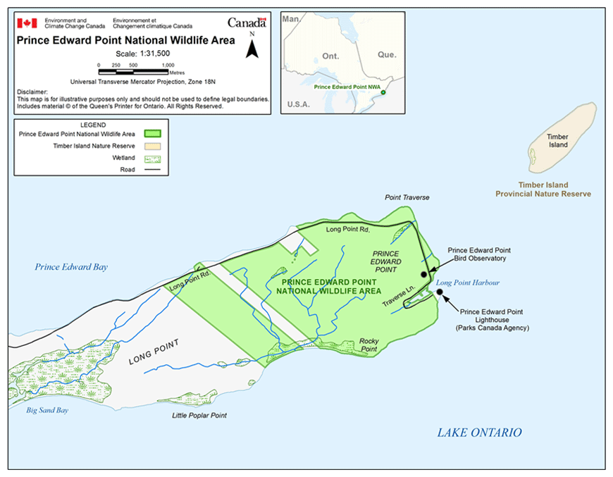
Long description for figure 1
Map showing Prince Edward Point National Wildlife Area and the surrounding area. The wildlife area is located at the eastern end of the Long Point Peninsula, along the northeastern shore of Lake Ontario. The Peninsula is surrounded by Prince Edward Bay on the North shore and Big Sand Bay on the South shore. The Wildlife Area is separated into two sections. The smaller section is located just west of the principal section on the point. Nearby features include Timber Island Provincial Nature Reserve, a bird observatory and lighthouse, and Long Point road that runs along the northern coast of the Peninsula to Long Point Harbour. The inset map shows the location of Prince Edward Point National Wildlife Area in the south-eastern area of Ontario, relative to Manitoba, Quebec, and the United-States. The scale of the map is in meters and the projection is Universal Transverse Mercator (Zone 18N).
1.1 Regional context
The Prince Edward Point NWA is within the Regional Municipality of Prince Edward County, along the northeastern shore of Lake Ontario (Figures 1 and 2). Nearby urban centres include the towns of Picton (the closest one, located 22 km to the northwest) and Belleville to the northwest, Napanee to the north, and the City of Kingston to the northeast.
Prince Edward County is an irregularly shaped peninsula characterized by flat limestone plains covered with a shallow layer of unconsolidated loamy soil. This physical feature was produced by the scouring action of glaciers on sedimentary rock. Agriculture has been the basis for the economy and the predominant land use in Prince Edward County for several generations. The climate, which is moderated by Lake Ontario, is suitable for orchards. In recent years, both wine production and the number of vineyards have increased in Prince Edward County attracting more tourism to the area.
Map source: Environment and Climate Change Canada, Canadian Wildlife Service - Ontario, 2016
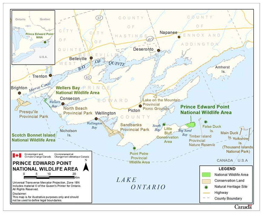
Long description for figure 2
Maps of Prince Edward Point National Wildlife Area in relation to the province of Ontario (inset map) and in relation to Prince Edward County on Lake Ontario (main map). The main map presents in more detail the boundaries and location in Prince Edward County of Prince Edward Point, Wellers Bay and Scotch Bonnet Island National Wildlife Areas, national and provincial parks and natural heritage sites. The inset map indicates that the Wildlife Area is located in southeastern Ontario. The map scale is expressed in kilometers and the projection is Universal Transverse Mercator (Zone 18N).
The Prince Edward Point NWA occurs at the tip of the Long Point Peninsula, at the southeastern end of Prince Edward County (Figures 1 and 2). Adjacent to the NWA along the north shore, there are cottages and a commercial recreational diving operation. Development pressures for marina, residential and tourist industry expansions appear to be increasing. In addition, wind power generation and the demand to increase wind turbine development is increasing along the Great Lakes shoreline.
The adjacent waters of Outlet Bay and eastern Lake Ontario have a long history of productive commercial, recreational, and Indigenous fisheries and are part of a key shipping route through the Great Lakes, and between Canada and the United States.
There a number of natural heritage sites in southern Prince Edward County in addition to the Prince Edward Point NWA including Big Sand Bay and provincially significant South Bay wetlands, Point Petrel Provincial Wildlife Area, Sandbanks Provincial Park, Little Bluff Conservation Area, Scotch Bonnet Island NWA and the Wellers Bay NWA. Additionally, Timber Island Provincial Nature Reserve and False Duck Island Conservation Area are part of the chain of islands that extend east of the NWA into Lake Ontario. These islands serve as a natural travel corridor for birds migrating in spring and fall across Lake Ontario between Canada and the United States. Yorkshire and Main Duck Islands are part of Thousand Islands National Park and Parks Canada once considered this area as a candidate National Marine Conservation Area to protect marine habitats and landforms representative of the Lake Ontario region (Figure 2).
Prince Edward Point NWA is one of three international Monarch Butterfly Reserves designated in southern Ontario as part of the 1995 Canada-Mexico declaration to create the International Network of Monarch Butterfly Reserves. Many thousands of migrating Monarch (Danaus plexippus) feed and rest at Prince Edward Point in late summer and early fall in preparation for their long journey south to Mexico (Hinterland Who’s Who 2003). The other two Canadian sites are Point Pelee National Park and Long Point NWA, which are both located on the northern shore of Lake Erie.
In 1998, the Canadian Nature Federation and Bird Studies Canada recognized Prince Edward County South Shore as a BirdLife International globally Important Bird Area (IBA). The IBA program seeks to identify and protect the most critical habitats for the world’s birds. The Prince Edward County South Shore IBA covers approximately 26 km2 of land along the south shore of Prince Edward County, including the entire Long Point peninsula and 65 km2 of nearshore waters of Lake Ontario and Prince Edward Bay (Wilson and Cheskey 2001). The Prince Edward County south shore was designated as a globally significant IBA because the numbers of Greater Scaup (Aythya marila), Long-tailed Duck (Clangula hyemalis), and White-winged Scoter (Melanitta fusca) exceed 1% of the global population. The south shore is also nationally significant because of the species at risk (as assessed by COSEWIC and Committee on the Status of Species at Risk in Ontario (COSSARO) Footnote1) found within the IBA (Wilson and Cheskey 2001).
Prince Edward Point has also been identified as a priority area for conservation in Bird Conservation Region (BCR) 13 under the North American Bird Conservation Initiative (NABCI)Footnote2 -- primarily because of its importance for waterfowl, waterbirds and landbirds.
1.2 Historical background
Before European settlement, most of the Long Point Peninsula and the Prince Edward Point NWA property were likely forested. During the Loyalist settlement days, lumbering removed most of the mixed hardwood forest in the area, and land was converted to mixed agriculture, including orchards and pasture. Most of the land was later abandoned, since the shallow soil was suitable only for light pasturing (Mohr and Maltby 1982).
Prince Edward County and the Long Point Peninsula have a long history as a wildlife and human travel corridor across Lake Ontario. In the mid-1960s, the Kingston Field Naturalists recognized Prince Edward County as an important staging area for migratory birds on the shore of Lake Ontario during spring and fall migration. They worked in co-operation with Environment and Climate Change Canada and prepared a proposal to acquire 190 ha of private land to establish one of Canada’s first NWA (Kingston Field Naturalists 1976). Subsequently, Environment and Climate Change Canada completed biological studies to assess the values of the proposed NWA. In 1978, Prince Edward Point NWA was established, and additional parcels were acquired between 1978 and 1981.
In the spring of 1985, under a permit from Environment and Climate Change Canada, the Prince Edward Point Bird Observatory (PEPtBO) established a banding and migration monitoring station within the NWA. Since its inception, staff and volunteers at this banding station, which is part of the Canadian Migration Monitoring Network, have recorded 334 species of birds, and have collaborated on research on other migratory species such as bats. In 1999, the Prince Edward Point Bird Observatory (PEPtBO) was designated as a full member of the Canadian Migration Monitoring Network, a program of Bird Studies Canada (Okines 2009).
Previous management plans have been prepared for the Prince Edward Point NWA (Lévesque 1985) and further rational for the management actions taken in the past can be found in these plans. This 2016 Prince Edward Point NWA Management Plan updates and replaces all previous versions.
1.3 Land ownership
The Surface title of the Prince Edward Point NWA belongs to the Crown in Right of Canada and is administered by Environment and Climate Change Canada’s Canadian Wildlife Service as described in Schedule 1 of the Wildlife Area Regulations of the Canada Wildlife Act. It is comprised of two parcels of land, which are separated by a segment of private property of approximately 40 ha (Figure 3). The Crown Right in Canada does not hold the subsurface mineral rights for either of the two parcels.
Map source: Environment and Climate Change Canada, Canadian Wildlife Service - Ontario, 2016
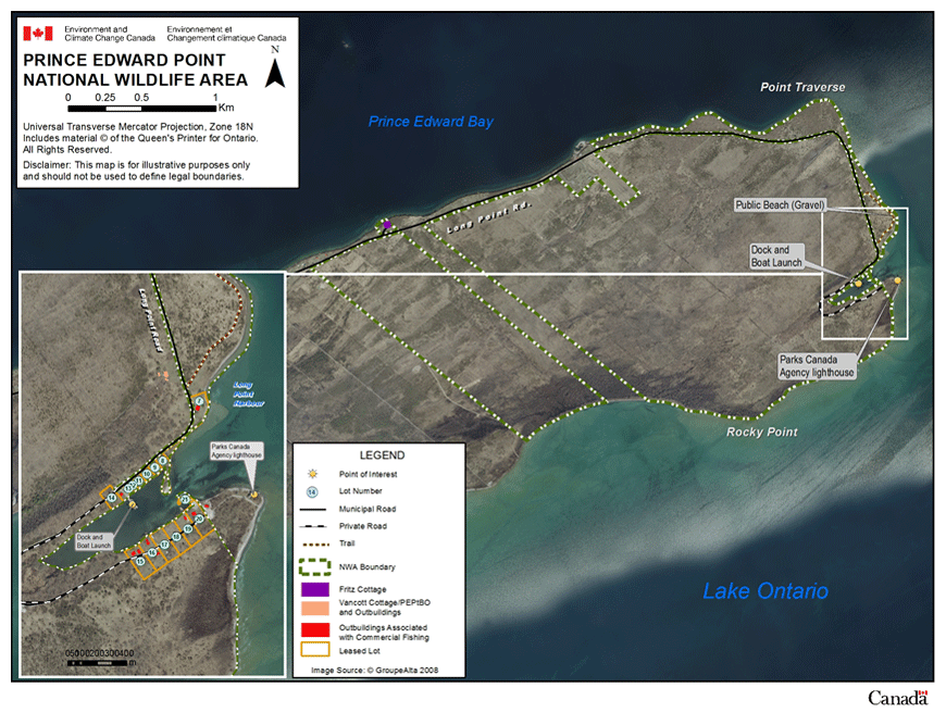
Long description for figure 3
Map showing an aerial (satellite) photo of Prince-Edward-Point National Wildlife Area in Lake Ontario, with its boundaries and features. Features are the municipal Long Point road, a private road, two parking areas along Long Point Harbour, a trail along the point of the Peninsula, a dock and boat launch, Parks Canada's lighthouse, and private and Wildlife Area buildings. The map scale is expressed in meters and the projection is Universal Transverse Mercator (Zone 18N).
The southern, eastern and northeastern NWA boundaries extend to the edge of Lake Ontario. Along the north-central and northwestern edge of the NWA, the boundary is Long Point Road. Land north of this road is privately owned except for the staff facilities known as the “Fritz Cottage”. A small section of land at the eastern tip of Prince Edward Point is owned by Parks Canada Agency and is administered by the Thousand Islands National Park. This is the location of the historic Point Traverse lighthouse, which is no longer in use. Entering the structure is prohibited, but visitors may walk on the property and view the exterior; access is through the NWA (around the harbor) by foot after the end of the municipal road.
Point Traverse (Long Point) Harbour is situated at the end of Long Point Road. A total of 21 small lots had been surveyed around the harbour (Figure 3) prior to the establishment of the NWA. Commercial use of leased lots is not ordinarily permitted in NWAs. When Environment and Climate Change Canada acquired the Prince Edward Point property in 1978, the Department made an exception and allowed commercial fishers with existing leases with the former landowner to continue to use the lots under permit for three years. In order to avoid any undue hardship, Environment and Climate Change Canada initially entered into 10 five-year leases with those leaseholders in 1981 to use the 21 lots for land-based activities to support their commercial fishing operations. These five-year leases allowed for a three-year extension. Therefore, in 1989, when they were not formally extended, if they had not already been terminated, the remaining leases went into “over-holding”, effectively a month-to-month lease situation. Some of the leaseholders are now retired or deceased, and their leases have been terminated.
The Prince Edward Point Bird Observatory leases one lot and its buildings, known as the “Vancott Cottage” for use and operation of the Canadian Migration Monitoring Network station. Their work contributes to the mission of the Canadian Wildlife Service.
Other commitments of federal land within the NWA include the municipal road allowance along Long Point Road, and agreements with Ontario Hydro and Bell Canada for service lines.
1.4 Facilities and infrastructure
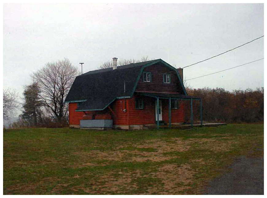
Structures on the NWA include: a) a field station (known as the Fritz cottage, named after the former owner) and garage, which serve as accommodation and equipment storage, respectively, for Environment and Climate Change Canada staff and researchers (Figure 4); b) a cottage (known as the Vancott cottage, named after the former owner), storage shed and bird banding shed; c) a number of small cabins and associated fishing net sheds and docks owned and used by commercial fishers; d) a recently-constructed public washroom facility; and e) a dock/wharf, vehicle and trailer parking area and boat ramp/launch (Table 2).
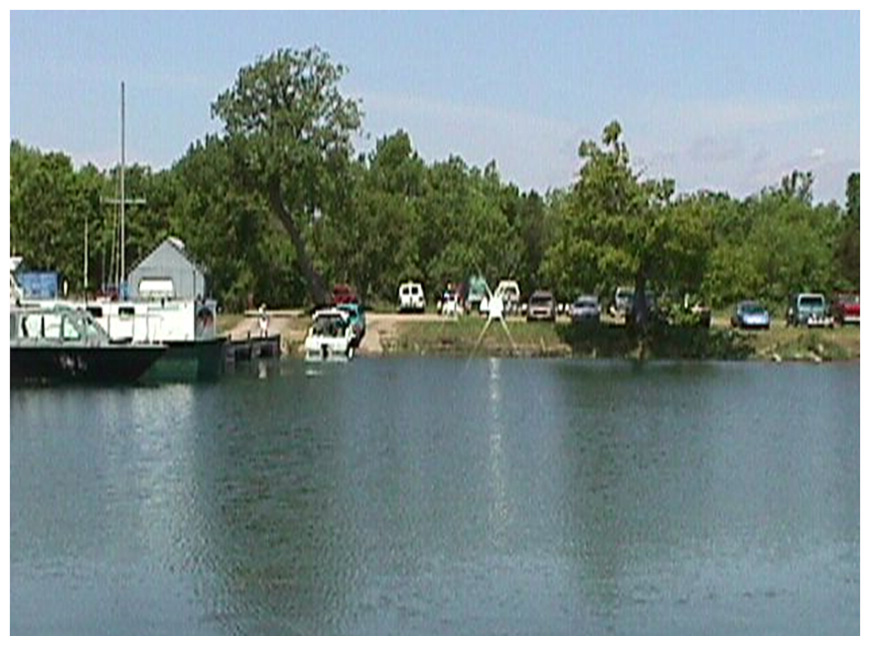
A capital project to refurbish the dock was completed in spring 2011. Overnight mooring is not permitted at this dock (Figure 5).
Long Point Road, which follows part of the northern border of the NWA, is owned and maintained by the Regional Municipality of Prince Edward County. This is the main access road to the NWA, and it ends at the dock and boat ramp. From this point onwards, the harbour access road is owned and maintained by Environment and Climate Change Canada. A fence and gate along Long Point Road, constructed 30 cm above the ground to allow wildlife to pass under it, was installed in 2010 to help prevent off-road vehicle accessing the NWA property. Visitors wanting to view the lighthouse are to walk on foot from the gate along the access road to the point. The use of motorized vehicles within the NWA, except on established roadways, is not allowed except by authorization from Environment and Climate Change Canada.
A public walking trail has been established (Figure 3). Additionally, a series of trails used for the bird observatory migration monitoring operations are open to the public seasonally after spring and fall migration. Two small, open grassed areas, adjacent to the boat launch in the harbour and on Point Traverse, are mowed and maintained for public use.
Concrete parking barriers were placed along the day use area shorefront in 2011 for safety reasons. Cable gates are in place to prevent vehicle access and protect the gravel beaches at this location.
Maintaining infrastructure is an ongoing need at the Prince Edward Point NWA. Regular maintenance is required in order to ensure the safety of authorized visitors, and to minimize potential risks associated with any built structures (e.g., dock, gates, and buildings).
Under the Connecting Canadians to Nature (CCtN) initiative (2015-2020), investments will be made over the next few years to repair and improve the existing trail network, signage, public access to various points of interest and infrastructure, and to update and improve interpretive materials.
Table 2: Facilities and infrastructure in Prince Edward Point National Wildlife Area
| Type of facility of infrastructure | Approximate Size | Responsibility holder or owner |
|---|---|---|
| Fritz cottage | 75 m2 | Environment and Climate Change Canada (ECCC) |
| Garage | 111 m2 | ECCC |
| Storage shed | 6 m2 | ECCC |
| Vancott cottage | 75 m2 | ECCC |
| Bird banding shed | 10 m2 | ECCC |
| Solar panel | 6 m2 | ECCC |
| Storage shed | 6 m2 | ECCC |
| Type of facility of infrastructure | Approximate Size | Responsibility holder or owner |
|---|---|---|
| 1 net shed | 10 m2 | Lot 7 |
| Fishing net sheds | 25 m2 | Lot 10 |
| Cabin / fishing net shed | 25 m2 | Lot 16 |
| Cabin | 25 m2 | Lot 18 |
| Trailer | 25 m2 | Lot 19 |
| Cabin | 25 m2 | Lot 20 |
| Fishing net shed | 25 m2 | Lot 21 |
| Type of facility of infrastructure | Approximate Size | Responsibility holder or owner |
|---|---|---|
| ECCC public dock / boat launch | 50 m2 | ECCC |
| Lot 16 dock | 15 m2 | Lot 16 |
| Lot 20 dock | 15 m2 | Lot 20 |
| Lot 21 dock | 15 m2 | Lot 21 |
| Type of facility of infrastructure | Approximate Size | Responsibility holder or owner |
|---|---|---|
| Long Point Road | 3.0 km | Municipality of Prince Edward County |
| Harbour Access Road / gate | 0.5 km | ECCC |
| Type of facility of infrastructure | Approximate Size | Responsibility holder or owner |
|---|---|---|
| Designated hiking trails | 0.5 km | ECCC |
| Parking / lawn area / dock | 0.5 ha | ECCC |
| Parking / lawn - day use | 0.5 ha | ECCC |
| Parking-day use concrete barricades | 30 | ECCC |
| Cable gates-day use area | 2 | ECCC |
| Fencing along west side of road-3 gates | 2km | ECCC |
| ECCC public washroom | 15 m2 | ECCC |
| Type of facility of infrastructure | Approximate Size | Responsibility holder or owner |
|---|---|---|
| Boundary signs | 100 | ECCC |
| NWA identification signs | 4 | ECCC |
| Public safety notices | 8 | ECCC |