
Sand Pond National Wildlife Area Management Plan: chapter 1
1 Description of the Protected Area
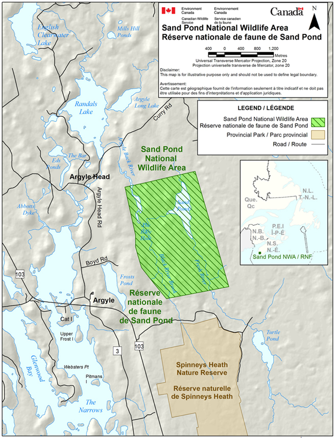
Sand Pond National Wildlife Area (NWA) is situated in southwestern Nova Scotia (43°48’N, 65°49’W), adjacent to Argyle in Yarmouth County (Figure 2). The larger municipality of Yarmouth is 22 km away. Sand Pond NWA encompasses an area of 532 hectares, of which 21% consists of vegetated wetlands and open water at Sand Pond, and 79% heath barrens and forest. The area is relatively remote and can only be accessed seasonally by Boyd Road. A portion of this road terminates within the NWA at an abandoned house site. A smaller trail extends from this point to a boat landing at the pond. Much of the habitat surrounding Sand Pond consists of dense woods, ericaceous bogs and meadows.
The area is important as a fall staging area for waterfowl, especially the American Black Duck (Anas rubripes). In fall, waterfowl that congregate along the coastal marshes and estuaries frequent this inland lake for food, grit and fresh water. Sand Pond NWA also provides protection to a diversity of Atlantic Coastal Plain Flora.
Sand Pond was designated the first NWA in Canada on April 27, 1978, and is administered under the Wildlife Area Regulations of the Canada Wildlife Act .
| Category | Information |
|---|---|
| Protected Area (PA) designation | National Wildlife Area |
| Province or territory | Nova Scotia |
| Latitude and longitude | 43°48’N, 65°49’W |
| Size | 532 ha (1315.5 acres) |
| Protected area designation criteria | Criteria 1(a), where the site supports significant concentrations of staging and migrating waterfowl. The site also supports Atlantic Coastal Plain Flora. |
| Protected area classification system | Category A - Conservation of species or critical habitat |
| International Union for Conservation of Nature (IUCN) classification | IV |
| Order in Council number | PC 1978-1439 |
| Directory of Federal Real Property (DFRP) number | DFRP number 2357 |
| Gazetted | April 27, 1978 |
| Additional designations | None |
| Faunistic and floristic importance | Important staging area for waterfowl. Significant concentration of Atlantic Coastal Plain Flora. |
| Invasive species | None recorded |
| Species at risk | None recorded |
| Management agency | Environment Canada - Canadian Wildlife Service |
| Public access and use | Public use is minimal. Day recreation is allowed within the NWA, including hiking, hunting and fishing. |
1.1 Regional context
Sand Pond, named for its sandy bottom, is a small freshwater lake situated 22 km due east of the town of Yarmouth, Nova Scotia, and 1.5 km inland from the tidal waters of the Argyle River. The adjacent coastal area consists of extensive tidal flats, inlets and coastal islands. This area, including nearby East River, Tusket Island and Goose Bay, is one of the more important fall staging and wintering areas for Black Ducks and Canada Geese (Branta canadensis) in Nova Scotia (Van Zoost 1969; MacKinnon et al. 1994).
Southwestern Nova Scotia, including Sand Pond, is important ecologically for its diversity of Atlantic Coastal Plain Flora (Crowley and Beals 2011), a unique group of unrelated plants that are mainly restricted to the flat lands along the Atlantic coast from Florida to Nova Scotia. Besides the inlets and coastal islands to the west and south, the NWA is bounded by the open barrens known locally as the Great Heath to the northeast, and Spinney’s Heath Nature Preserve to the south. Spinney’s Heath is a 640-hectare protected area administered by the Province of Nova Scotia under the Special Places Protection Act . This site was identified in 1971 under the International Biological Program as an excellent example of an undisturbed open Sphagnum bog.
The many bays and inlets along the coast of southwestern Nova Scotia, and close proximity to fishing grounds around the mouth of the Bay of Fundy and Gulf of Maine, make these coastal resources a significant driving force for the local economy. The region’s interior geography consists of generally rugged terrain unsuitable for larger farming operations; as a result, the majority of communities are coastal, with only a few small settled areas in the hinterland.
Sand Pond is situated within the Atlantic Maritime Ecozone (Figure 3). One of 15 terrestrial ecozones in Canada, the Atlantic Maritime Ecozone includes all of New Brunswick, Prince Edward Island, Nova Scotia and Quebec’s Gaspé Peninsula. Within this ecozone, the NWA is situated in the Southwest Nova Scotia Uplands Ecoregion (124), between the Tusket River (513) and Rossignol (514) ecodistricts (Webb and Marshall 1999).
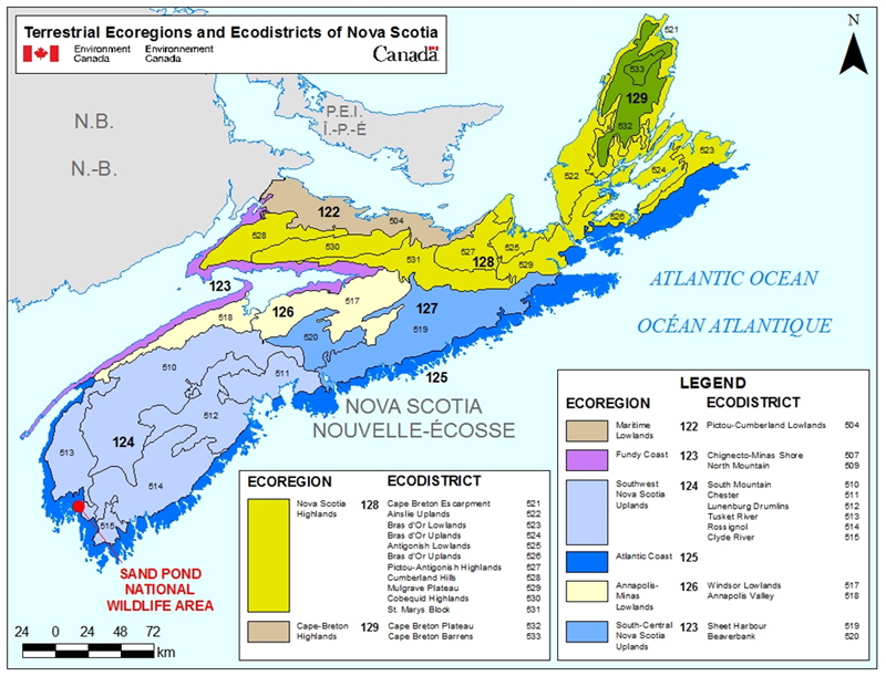
Long description for Figure 3
A map of terrestrial ecoregions and ecodistricts in Nova Scotia, indicating the location of Sand Pond National Wildlife Area within the Atlantic Maritime Ecozone and the Southwest Nova Scotia Uplands Ecoregion, and between the Tusket River and Rossignol ecodistricts. There are 8 ecoregions in the province, which are further subdivided into 26 ecodistricts. Map scale in kilometres.
1.2 Historical background
It was around 1895 that the first farms appeared on the uplands around Sand Pond. Forests were cleared, leaving significant stone walls around the remnant old fields that are a lasting legacy to this work. A flooding and drainage system was constructed to optimize cranberry production and harvest. On completion, most of Sand Pond was drained, and 25 acres were cultivated as a cranberry bog. A control structure was also built at the outflow of the lake so that cranberries could be flooded. A more complete account of historical land use at Sand Pond is contained in Appendix I.
1.3 Land ownership
The wetlands and entire uplands of Sand Pond NWA are owned by the Government of Canada and administered by the Canadian Wildlife Service of Environment Canada. The property is rectangular in shape and the linear boundaries are clearly delineated.
The access road (Boyd Road) to the site of the former homestead at Sand Pond is under the administration and control of the Province of Nova Scotia.
The federal government does not hold the subsurface mineral rights for Sand Pond NWA.
1.4 Facilities and infrastructure
There are no buildings and only minimal public use facilities within Sand Pond NWA. Boyd Road, the designated road connecting the old homestead to Sand Pond, is seasonally accessible by high-clearance vehicles and requires minor maintenance for EC employees, that are primarily the periodic removal of encroaching vegetation. Annual visits include site inspections and repairs and replacement of regulatory signage, such as boundary signs, public notices and 2' × 4' NWA identification signs (Van Zoost 1969; Hounsell 1974; MacKinnon et al. 2010; MacKinnon and MacPherson 2011).
| Type of facility or infrastructure | Approximate size (m, m2, km, km2 or linear m) or number |
Responsibility holder or owner |
|---|---|---|
| Property boundary | 9.7 km | Environment Canada - Canadian Wildlife Service (EC-CWS) |
| Boundary signs | 200 | EC-CWS |
| NWA entry signs | 1 | EC-CWS |
| Public notice signs | 5 | EC-CWS |
| Trail (Sand Pond) | 900 m | EC-CWS |
| Trail (unimproved) | 900 m | EC-CWS |
| Designated public road | 800 m | Province - Nova Scotia |
| Bridge | 1 | Province - Nova Scotia |
| Boat landing (<10 hp) | 1 | EC-CWS |
| Maintenance access points | 1 | EC-CWS |
| Water control structure | 1 | Ducks Unlimited Canada |