
Tway National Wildlife Area Management Plan, 2016: chapter 3
3 Management Challenges and Threats
There are six management challenges and threats affecting the future ecological condition of Tway NWA.
3.1 Alien invasive species
The majority of the upland grassland vegetation in the NWA is comprised of three invasive alien grasses (Smooth Brome, Quackgrass, Kentucky Bluegrass). Three invasive noxious weeds (Perennial Sow-thistle, Canada Thistle, Common Tansy) and a non-native legume (Sweet Clover) are widespread. These species have invaded the remnant native grassland communities, reduced plant community diversity, altered the structure of nesting habitats, and changed forage supplies for livestock and wild ungulates. Eradication of alien invasive plants is not feasible. Management efforts should focus on controlling invasive species to the extent that wildlife habitat values are maintained or enhanced.
The management decision to reseed cropland to tame forage grasses and legumes in the 1970s, and then to allow much of that vegetation to go unmanaged for years, has been the greatest source of seed for the widespread invasion of alien invasive species in Tway NWA. Habitat and landscape requirements for waterfowl are not always suitable for other bird species, particularly endemic grassland songbirds, many of which are species at risk. Perennial cover is still important to grassland songbirds (McMaster and Davis 2001), but responses to the structure of that cover and the surrounding landscape differ between songbirds and ducks (McMaster et al. 2005). For example, some songbird species depend upon grazed native grasslands with shorter cover and may avoid shrubland habitats or wetland margins (Koper and Schmiegelow 2006, 2007; Skinner and Clark 2008).
Feral Wild Boars are an emerging issue in the surrounding region, and this species may pose a threat to native biodiversity (Brook 2014).
3.2 Artificial water control structures
The natural course of the Carrot River was altered for the Tway Lakes Project. Two water control structures exist in Tway NWA (Figure 3), and several other water control structures that are managed by other agencies occur upstream and downstream of Tway NWA on the Carrot River. Water control structures tend to exacerbate floods in wet cycles and often interfere with fish passage. Flooding wetlands may raise groundwater tables in gravelly-sandy soils, leading to increased salinity and greater abundance of invasive alien species.
Historically, infrastructure on Tway NWA has required heavy equipment access, excavation and dumping of soil and subsoil, and installation of metal and cement structures. Operation of this infrastructure requires vehicle access several times each year between April and October to monitor water levels and make decisions regarding placement or removal of stoplogs. In this region, natural closed-basin wetlands fill early in the year with spring runoff from snowmelt and lose water from evaporation or seepage thereafter (Stewart and Kantrud 1971). However, several wetland basins on Tway NWA have artificial inlet and outlet connections that support an unnatural flow of fresh river water for several days or weeks in late spring each year to help fill downstream basins. Occasionally, Beavers and Muskrat must be trapped, trees and shrubs cut, grassland mowed, and ditch bottoms dredged in order to keep the engineered structures operating. This type of intensive management is not in keeping with DUC's current preference to minimize ecological management and avoid intensive project operations such as removing stoplogs to manage drawdowns (Uhrich, pers. comm.).
The DUC water control structures in Tway NWA have served their useful life and now need to be rebuilt or decommissioned. Continuing degradation of the structures may lead to safety hazards. Rebuilding the infrastructure at the Tway Lakes would involve installing fixed crest steel sheet pile weirs designed for a 50-year project life. Such control structures would have mild slope rock spillways to provide improved passage for fish (e.g., Northern Pike [Esox lucius] and Walleye[Sander vitreus]) and reduce vulnerability to beaver damage. DUC is looking for partners to fund reconstruction of the Tway Lakes Project and provide for long-term management.
Decommissioning the Tway Lakes Project would involve removing controls and modifying works to return the wetlands to a naturalized water level. The naturalized water levels would be lower, with reduced depth on Tway Lake and only remnant shallow wetlands remaining on the downstream basins (Uhrich, pers. comm.).
Either option, redevelopment or removal, will require time to make resources and personnel available. The activities necessary to rebuild or remove the water control structures in Tway NWA are prohibited activities described in section 3 of the Wildlife Area Regulations. The primary mitigating factor to allow these activities on Tway NWA is the potential positive outcome for wetland habitats, water bird populations and human safety.
If decommissioning were to occur, reductions in size of the wetlands would potentially require active vegetation restoration activities to avoid colonization of former wetlands areas by invasive species.
3.3 Fire and fire suppression
Fire suppression in the region has allowed many woody species to proliferate and invasive alien species to spread. Both of these changes reduce vegetation diversity. Historic air photos show an increase in Aspen stands from the 1970s to the present. In Fescue Prairie, spatial heterogeneity and species composition increase after a single burn, which results in patchier plant communities (Gross and Romo 2010). Fire return intervals of 10 to 11 years should be considered for Fescue Prairie (Pylypec and Romo 2003). This would benefit many wildlife species that use the habitat within Tway NWA, including grassland birds, which exhibit declines in abundance and nest densities as woody cover increases (Grant et al. 2004, Davis 2005).
3.4 Livestock grazing
Grazing has the potential to create spatial and temporal heterogeneity in grassland vegetation structure, which can have beneficial effects on native grassland as habitat for wildlife (Fuhlendorf et al. 2012). Deferred grazing with cattle has been used at Tway NWA to create heterogeneity in nesting habitat and remove litter build-up to reduce potential fire intensities.
Lack of active management of seeded grassland for several decades while deferring grazing to late summer and fall has resulted in seed production and widespread invasion by various perennial and biennial alien plant species. While this vegetation community serves as nesting cover for ducks and preferred habitat for Northern Pocket Gophers and mice, it is unsuitable habitat for most other upland migratory bird species or species at risk.
Grazing has been absent from Tway NWA since 2008, resulting in increased invasion of tame forages into native grasslands and the expansion of Aspen communities. The number of livestock producers in the Tway region may have declined, creating a possible challenge to find a permit holder willing to carry out the specific grazing prescriptions designed to benefit wildlife in the NWA.
3.5 Gravel extraction
Several gravel pits are located in the vicinity of Tway NWA, and gravel is hauled to Saskatoon via Highway 41. Gravel pit operations are noisy and may directly disturb wildlife in the immediate vicinity, or indirectly modify wildlife habitat by altering local water tables and drainage patterns and introducing new alien invasive species. There will be increasing pressure on adjacent lands as existing gravel pits are depleted. Every year, there are requests for permits to develop gravel resources on other NWAs in Saskatchewan, and a future request to do so on Tway is likely.
3.6 Agricultural effluents
The Carrot River Watershed is classified as Stressed due to reduced surface and groundwater quality and rangeland and riparian health issues (Saskatchewan Watershed Authority 2012b).
The surrounding watershed is several hundred square kilometres and includes lands subject to drainage. The runoff from that drainage contains unused fertilizers and pesticides, which can cause nutrient loading of wetlands along the Carrot River and contamination of wetlands with residual herbicides, fungicides and insecticides or their breakdown products. Fertilizer application (nitrogen and phosphorous) and pesticide application are rated as high intensity in the watershed. The severity of these effects over the long term is uncertain. Livestock effluents were rated as a moderate intensity in the watershed but may have more local impacts (Saskatchewan Watershed Authority 2012b).
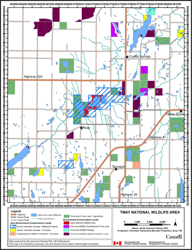
Long description for figure 4
Map showing conservation lands within the vicinity of Tway NWA. Tway NWA is shown in the centre of the map, included within a Ducks Unlimited Canada Wetland Project. There is another such project located southwest of the NWA. Map shows four lands purchased by Ducks Unlimited Canada, two southwest of the NWA and two northeast of the NWA. The Saskatchewan Wildlife Federation purchased land southeast of the NWA. Map also indicates government conservation lands such as fish and wildlife development fund lands, east and northeast of the NWA, a provincial wildlife refuge northeast of the NWA, and provincial wildlife habitat protection lands. Map shows other lakes, communities such as Crystal Springs, Yellow Creek, Tway and Tarnapol, highways 320, 41 and 20, and other roads. The scale on the map is in meters and the Universal Transverse Mercator Projection is Zone 13N. Disclaimer: This map is for illustrative purposes only and should not be used to define legal boundaries. Highways, paved and gravel roads, lakes and large wetlands, creeks and rivers and agricultural provincial Crown lands are indicated on the map, as well as Non-Government Conservation Land such as Ducks Unlimited Canada - Wetland Projects, Ducks Unlimited Canada - Purchase, and Saskatchewan Wildlife Federation - Purchase, and Government Conservation Land such as Tway NWA, Fish and Wildlife Development Fund Land, Provincial Wildlife Refuge, and Provincial Wildlife Habitat Protection Land.