
Vaseux–Bighorn National Wildlife Area Management Plan: chapter 1
1. Site description
Vaseux-Bighorn National Wildlife Area (NWA) is located in the South Okanagan- Similkameen region of British Columbia. The Canadian Wildlife Service (CWS) of Environment Canada manages several separate units of land that together comprise this NWA. The NWA is adjacent to Vaseux Lake (a federal Migratory Bird Sanctuary (MBS) established in 1923), large areas protected by the province, extensive Nature Trust of B.C. land holdings, and properties managed by the Land Conservancy of British Columbia (B.C.) and Nature Conservancy of Canada (Figure 1).
Vaseux-Bighorn NWA was established in 1979 to protect habitat for species deemed to be special and important, including the California Bighorn Sheep, which was at risk of disappearing from the valley at that time. As a result of continental-scale changes in population sizes and habitat quality and availability, many of the species found in Vaseux-Bighorn NWA have since been assessed by the Committee on the Status of Endangered Wildlife in Canada (COSEWIC); most of those species are now also listed under the federal Species at Risk Act (SARA).
In addition to providing significant habitat for species at risk, this NWA supports many other species of migratory birds, mammals, reptiles, insects and plants (Table 1). It is a dynamic natural system, and is influenced by erosion, flooding, fire, grazing and other natural processes.
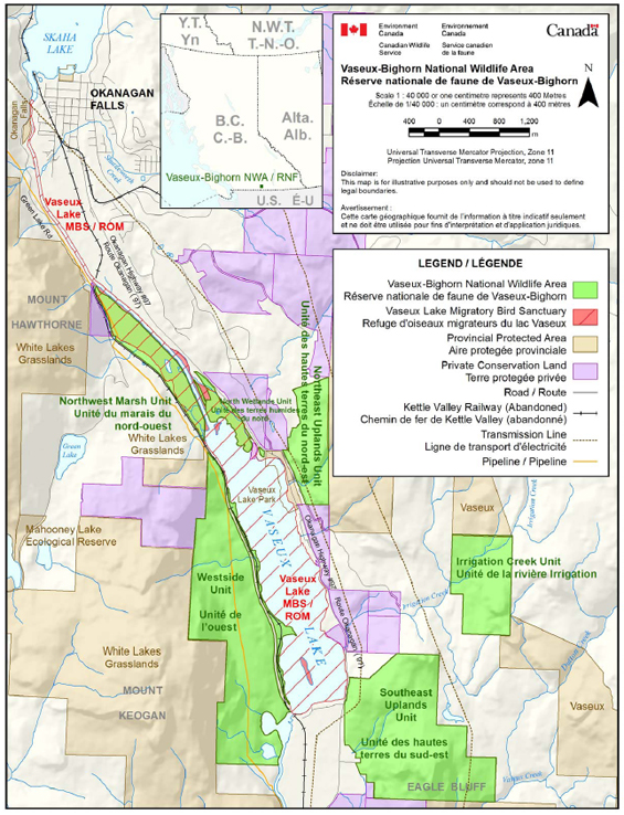
Long description for Figure 1
Map of the location of Vaseux-Bighorn NWA in relation to British Columbia. The Vaseux Lake is surrounded by six polygons representing the NWA, six other private conservation land polygons and several polygons representing provincial protected areas. On top of the Vaseux lake and few polygons of the NWA, there is the Vaseux Lake MBS.
| Category | Information |
|---|---|
| Protected Area designation | National Wildlife Area |
| Province/territory | British Columbia |
| Latitude/longitude | 49°17’ N 119°33’ W |
| Size (hectare (ha)) | 812 ha, comprising several disjunct parcels |
| Protected Area designation criteria | Historic: protection of critical winter range for California Bighorn Sheep. Current: 2(a) “the area supports an appreciable assemblage of rare, vulnerable, threatened or endangered species.” |
| Protected Area Classification System | A (high) species or critical habitatconservation |
| International Union for Conservation of Nature Classification | Category IV - Habitat Management Area |
| Order in Council Number | PC 1979 - 648 |
| Directory of Federal Real Property number | 70878 |
| Gazetted | 1979 |
| Additional designations | None |
| Faunistic and floristic importance | Rare plant communities (identified by the B.C. Conservation Data Centre as red- or bluelisted): Antelope Brush, Needle-and-Thread Grass, Water Birch, Red Osier Dogwood, Bluebunch Wheatgrass, Arrow-Leaved Balsamroot, and Ponderosa Pine-Bluebunch Wheatgrass communities |
| Invasive species | Riparian (example (e.g.), Purple Loosestrife), aquatic (e.g., Eurasian Milfoil), upland (e.g., Sulphur Cinquefoil, Reed Canary Grass, Cheatgrass, Smooth Brome, Bull Thistle, Diffuse Knapweed, Hound’s Tongue, St. John’s Wort |
| Species at risk | 30 listed on Schedule I of the Species at Risk Act |
| Land/aquatic use | Public wildlife viewing platform in the NorthWetlands Unit |
| Management agency | Canadian Wildlife Service |
| Public access/use | Public access allowed only on designated trail,wildlife viewing tower and boardwalk |
1.1 Regional context
Vaseux-Bighorn NWA occupi es 812 hectares (ha) of mainly low-elevation habitats in the Vaseux Lake basin. A dry climate and desert-like habitats characterize the basin, which forms the northern tip of the Great Basin Desert and contains one of the highest concentrations of species at risk and highest species diversity in Canada. At Vaseux Lake, the South Okanagan River valley narrows significantly and rises steeply from small wetlands, marshes and ravines to shrub-grasslands, forested benches, and parkland habitats, then to rocky outcrops, talus slopes, and finally to the higher-elevation cliffs above. Ponderosa Pine and mixed Ponderosa Pine-Douglas Fir parklands are the predominant forest types throughout the NWA. The NWA provides habitat connectivity between protected areas and grazing lands on either side of the South Okanagan Valley.
Situated 25 kilometres (km) south of Penticton, B.C., between Oliver and Okanagan Falls, Vaseux-Bighorn NWA includes the following six distinct management units:
- Irrigation Creek Unit: This unit spans Irrigation Creek in the hillsides east of Vaseux Lake. The western portion of the unit is relatively flat, consisting mostly of immature mixed Ponderosa Pine and Douglas Fir forests, interspersed with wet meadows and paper birch in the gullies. The eastern portion of the unit contains pockets of steeply sloped grassland that give way to more rugged terrain, chiefly rocky terraces and steep cliff faces (Chapman et al. 1997d).
- Southeast Uplands Unit: This unit extends from the southeastern shores of Vaseux Lake. It is characterized by rugged terrain, consisting of grasslands, steep cliffs, rocky outcrops, dense forest, and parkland forest. Grasslands dominated by Antelope Brush, Sagebrush and Bluebunch Wheatgrass are all found within this unit (Chapman et al. 1997e).
- Northeast Uplands Unit: This unit extends above the western shores of Vaseux Lake. Shoreline riparian areas give way to upland slopes and benches consisting primarily of open Ponderosa Pine forest. Moving further upslope, these benches, in turn, become rocky cliffs and outcroppings, talus slopes, higher-elevation grasslands, and Ponderosa Pine parklands (Chapman et al. 1997c). Adjacent lands include a vineyard, which runs along the northwest side of the unit and extends down to the Northwest Marsh Unit.
- Westside Unit: This unit extends above the western shores of Vaseux Lake. Similar to the Southeast Unit, the Westside Unit includes wetlands, forested benchlands, grassy parklands, rocky talus slopes, and higher-elevation ridges (Chapman et al. 1997b).
- North Wetlands Unit: This unit encompasses the extensive wetlands surrounding the Okanagan River channel and dyke system at the north end of Vaseux Lake (Barnett 2000). This wetlands complex is one of the largest remaining in the Okanagan Valley. Associated riparian vegetation provides important breeding habitat for migratory birds. These wetlands form part of Vaseux Lake MBS (Bryan et al. 1997).
- Northwest Marsh Unit: This unit extends up the channel from Vaseux Lake and includes over 2 km of shoreline. The riparian habitat consists of marshes and oxbows (old river-channel ponds and ditches separated from the river by channelization of the Okanagan River), riparian woodlands, moist pastures, and hayfields (Bryan et al. 1997).
The NWA partially overlaps the Vaseux Lake MBS designated in 1923. This sanctuary was designated under the Migratory Birds Convention Act to protect a wintering flock of Trumpeter Swans considered endangered at the time (Alvo 1996). The lake and associated marsh wetlands remain an important breeding and stopover site for waterfowl and many other species of migratory birds. The Vaseux Lake Important Bird Area includes part of Vaseux Lake MBS.
The old Kettle Valley Railway right-of-way runs through the Westside Unit, but is not part of the NWA.
1.2 Historical background
The South Okanagan-Similkameen Region was first occupied by the Okanagan (Syilx) First Nations people, and is considered by them to be part of the traditional territory of the members of the Okanagan Nation (Okanagan Nation Alliance 2004). The area that today comprises Vaseux-Bighorn NWA supported significant historical occupation and use by First Nations people, who used and managed the resources of the valley.
The Vaseux area has some of the most diverse, abundant and intact archaeological sites in the Okanagan Valley. Concentrations of archaeological sites are found at several locations near Vaseux Lake, some of which include pictographs drawn by the Okanagan Aboriginal peoples. Cultural sites of note within the Vaseux area include habitation features, rock shelters, shell middens, cache pits, drying rocks, fish weirs, quarry sites, lithic debris accumulations, burial sites and trails. Little physical evidence exists of traditional hunting and gathering areas in the NWA, but it was undoubtedly extensively used (and still is used) by First Nations people. In addition to the assertions of the Okanagan people themselves, several key factors have contributed to the prolific evidence of traditional Aboriginal use of the area. They include the close proximity of considerable resources (e.g., freshwater, firewood, rock shelters), and abundant faunal resources such as ungulates, waterfowl, upland game birds, fish and freshwater mussels (Chapman et al. 1997a).
Diverse and abundant plants were also used by Aboriginal peoples, including for food, tools and medicines (e.g., Arrow-Leaved Balsamroot, Saskatoon Berry, Chokecherry, Mariposa Lily, rabbitbrush, elderberry, tule, et cetera (etc.)).
In the early 1800s, Europeans began to explore and colonize the region, driven first by the fur trade and subsequently by the supply demands of the Cariboo gold rush. In the 1880s the area experienced its own small gold rush, but it was not until 1918, when the Southern Okanagan Lands Project was established, that major irrigation works were undertaken as part of a larger veteran settlement scheme. The town of Oliver, B.C., was laid out in the 1920s and water irrigation was used to intensify agricultural production (Brotherton 2004). With its rich soils and grassland benches, the South Okanagan-Similkameen Valley quickly became one of the most productive agricultural areas in Canada. Orchards and vineyards in the region today produce fruits and vine products of high quality. The channelization and damming of the Okanagan River for flood control purposes in the 1950s significantly altered the landscape of the South Okanagan, including a portion of Vaseux Lake MBS.
An NWA for the Vaseux Lake basin was first proposed in 1970. A feasibility study and assessment of the plant and wildlife species inhabiting the area was completed (Keller 1977, 1978, 1979) and lands were subsequently purchased with the assistance of the Okanagan-Similkameen Parks Society. The wildlife area officially became a federal property in 1979. Vaseux-Bighorn NWA took its name from Vaseux Lake and the area’s flagship wildlife species, the California Bighorn Sheep.
1.3 Land ownership
The surface title of Vaseux-Bighorn NWA is in the name of the federal government, while the subsurface mineral rights are held by the provincial Crown. Adjoining lands are owned by the province and private interests, including conservation organizations such as The Nature Trust of B.C., the Land Conservancy of B.C. and the Nature Conservancy of Canada.
There are three rights of way on title:
- one running along the Westside Unit of the NWA to facilitate operation of a pipeline; and
- two crossing the Southeast Upland Unit of the NWA to facilitate operation of transmission lines.
Access to and use of any of these are subject to agreements between the companies and Environment Canada, and require permits for maintenance or other works.
1.4 Facilities and infrastructure
The only facilities and infrastructure in the NWA consist of a boardwalk, a portion of a parking lot, a gate, and a wildlife viewing tower. The boardwalk is jointly maintained with the Nature Trust of B.C. Those assets that require funds to upgrade or manage, and are the responsibility of Environment Canada-CWS, are listed in Table 2.
| Type of AssetFootnote[1] | Approximate Size | Responsibility |
|---|---|---|
| Parking lot | 1408 meter (m)2 | CWS and Province of B.C. |
| Gate | not available (N/A) | CWS and Province of B.C. |
| Boardwalk | 375 m2 | CWS and The Nature Trust of B.C. |
| Viewing tower | 10 m2 | CWS |