
Wallace Bay National Wildlife Area Management Plan: chapter 1
1 Description of the protected area
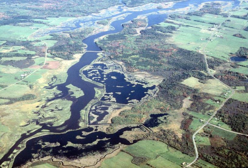
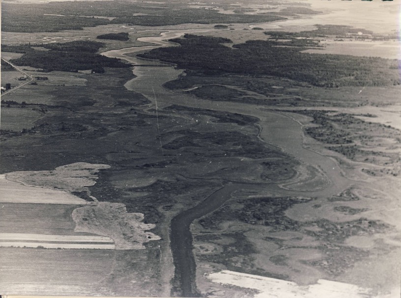
Wallace Bay National Wildlife Area (NWA) is located at the headwaters of Wallace Bay and is situated immediately west of the mouth of the North Wallace River in Cumberland County, Nova Scotia (45° 50’ N 63° 34’ W). This NWA is composed of a rich diversity of habitats in a comparatively small area, from a progression of salt marsh, brackish marsh and controlled water level freshwater marshes to an upland border of forests and open lands (Figure 1 and Figure 2).
The NWA is divided into two segments by a road and an adjacent tide gate, or aboiteau. This water control structure protects approximately 250 hectares (ha) of predominantly freshwater wetlands on the western side of the roadway including wooded swamp, freshwater impoundments, semi-tidal marshes, and river channel. On the harbour side of the aboiteau, the NWA is comprised of approximately 195 ha of salt marsh, tidal channels and impoundments. These saltwater wetlands are bordered by a mosaic of approximately 140 ha of uplands comprising mixed coniferous and deciduous forests, old fields in the early stages of plant succession, and agricultural lands.
This coastal site is an important staging and migration area for waterfowl and other wetland obligate birds. Wallace Bay NWA is managed by the Canadian Wildlife Service of Environment and Climate Change Canada and is classified as an International Union for Conservation of Nature (IUCN) Category VI protected area. IUCN classification is based on management objectives, and Category VI conserves ecosystems and habitats focusing on maintaining the sustainable use of natural resources.
Lands at Wallace Bay were purchased between 1971 and 1973 from private interests by the Government of Canada, and the site was declared a National Wildlife Area on June 5th, 1980. Wallace Bay NWA is administered under the Wildlife Area Regulations of the Canada Wildlife Act .
| Category | Information |
|---|---|
| Protected area designation | National Wildlife Area |
| Province or territory | Nova Scotia |
| Latitude and longitude | 45° 50’ N 63° 34’ W |
| Size (ha) | 585 ha |
| PA designation criteria | Historic: Protecting an area with concentrations of birds. Current: Meets criteria 1(a), where “the area supports a population of a species or a subspecies or a group of a species which is concentrated, for any portion of the year”. The area also satisfies criteria 2(b), where “the area has special value for maintaining the genetic and ecological diversity of a region because of the quality and uniqueness of its flora and fauna”. |
| PA classification system | Reference: PA Manual Appendix 8. |
| International Union for Conservation of Nature (IUCN) classification | VI |
| Order in Council number | PC 1980-1479 |
| Directory of Federal Real Property (DFRP) number | DFRP number 03217 |
| Gazetted | June 5, 1980 |
| Additional designations | None |
| Faunistic and floristic importance | The area contains significant coastal wetlands, including both freshwater and saltwater marshes, and is an important area for waterfowl and wetland birds. A high diversity of habitats occurs within a small area. |
| Invasive species | Localized Norway Maple (Acer platanoides) occurs at abandoned house sites. |
| Species at risk | Few species at risk have been recorded. Peregrine falcon is likely the only known common fall visitor (see Section 2.3). |
| Management agency | Canadian Wildlife Service |
| Public access & use | Access to Wallace Bay NWA is permitted for activities such as wildlife observation, photography, berry picking (non-commercial), hiking and canoeing. Hunting, fishing, and trapping (predominantly of muskrat) are allowed as authorized by posted notices at the entrance of the NWA and in accordance with applicable federal and provincial regulations. A public parking lot and boat launch is situated on the Aboiteau Road; use of watercraft under 10.0 horsepower is allowed. |
| Other appropriate information | Boaters must exercise caution if operating near the tide gate under Aboiteau Road, the public road that bisects the NWA. Check the tides. |
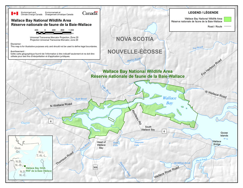
Long description for Figure 2
Map showing the boundaries of Wallace Bay National Wildlife Area, located in Nova Scotia. The wildlife area is at the headwaters of Wallace Bay and is divided in two fairly equal segments by the Aboiteau road. Several roads are shown including the 6, the 368, Wallace River Road, Thomson Road, N Wallace Road, Fox Harbour Road, and Aboiteau Road. The inset map shows the location of Wallace Bay National Wildlife Area in the north-eastern area of Nova Scotia, relative to New Brunswick, Newfoundland and Quebec. The scale on the map is in hundreds of meters and the projection is Universal Transverse Mercator (Zone 20).
1.1 Regional context
Wallace Bay NWA is an elongated 585 ha parcel of land, with irregular borders, situated at the headwaters of Wallace Bay in Cumberland County, Nova Scotia (Barkhouse 1980). The NWA lies within the Atlantic Maritime ecozone, one of fifteen terrestrial ecozones in Canada. The Atlantic Maritime ecozone includes all of New Brunswick, Prince Edward Island, Nova Scotia and Quebec's Gaspé Peninsula. Within this ecozone, the NWA is situated within the Maritime Lowlands ecoregion and the Pictou-Cumberland Lowlands Ecodistrict (Webb and Marshall 1999) (Figure 3).
In the classification system of the province of Nova Scotia, the NWA is also part of the Northumberland Bras d'Or Lowlands ecoregion and the Northumberland Lowlands Ecodistrict (Neily et al. 2003). This region is characterized as having a low elevation seldom greater than 50 m, and one of the best growing climates in Nova Scotia. The waters of the Northumberland Strait help moderate temperatures, delaying the onset of frost for a few weeks. The mean annual precipitation is comparatively low for the province, at 1128 mm; areas along the coast may be somewhat drier than inland (Neily et al. 2003).
The underlying geography consists of Carboniferous sediments of red sandstone with occasional deposits of gypsum and salt (Roland 1982). The closest commercial mining operation is the Canadian Salt Co. Ltd, situated 5 km west of the NWA near the village of Pugwash (Neily et al. 2003).
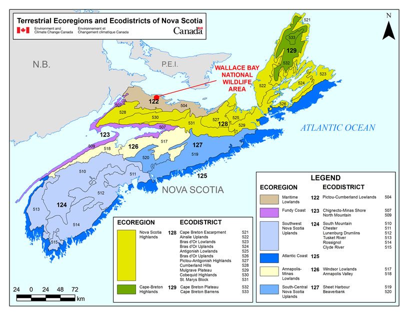
Long description for Figure 3
Illustration showing the terrestrial ecoregions and ecodistricts of Nova Scotia and the location of Wallace Bay National Wildlife Area. Eight ecoregions are shown, with Wallace Bay Wildlife Area being located within Ecoregion No. 122, Maritime Lowlands. 26 ecodistricts are shown, with Wallace Bay Wildlife Area being located within Ecodistrict No. 504, Pictou-Cumberland Lowlands, in the north-eastern area of the province. The scale on the map is in kilometers. The legend shows all ecoregions and ecodistricts present in Nova Scotia.
1.2 Historical background
The Wallace Bay area was once known as the Remsheg; the name is apparently derived from a Mi’kmaq word meaning “the place between” (Brown 1973). The area was undoubtedly important to the Mi’kmaq for its productive coastal waters rich in waterfowl, shellfish, and anadromous fish such as Gaspereau (Alosa pseudoharengus) and Blueback Herring (Alosa aestivalis).
Acadians established a small settlement at Wallace Harbour around 1710 and reclaimed the coastal marshes from the sea. Following the Acadian expulsion of 1755, the lands around Wallace Bay were resettled by United Empire Loyalists from New York in 1784. Much of the area they settled was included in what is called the “Remsheg Grant” (Brown 1973). Many of the names of families that settled the “Remsheg Grant” can be found on the Church map of circa 1873 (Figure 4); a number of the settlers’ descendants still have a strong attachment to the land and occupy these same farms today.
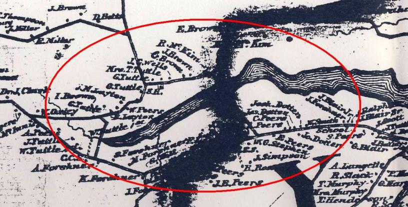
Long description for Figure 4
Historical 1873 map depicting homesteads in the vicinity of the head of Wallace Harbour. Roads and houses are shown on the map. Names of land owners are indicated on the map. Circle shows roughly the present-day Wallace Bay National Wildlife Area.
By the mid- to late 1800s, the dyked and drained reclaimed marshland produced very valuable hay crops. These low lying lands were suitable for horse-drawn hay making equipment, and the sale of this crop made an important contribution to the area's economy throughout the late nineteenth century. Hay farming continued for several years into the 20th century, but increased mechanization and a reduced labour force eventually resulted in less land being used. There were continued attempts to hold back the sea at the aboiteau into the beginning of the twentieth century (Figure 5). However, by the end of World War II, marginal lands and the marshlands were almost totally abandoned except for some pasture (Brown 1973).
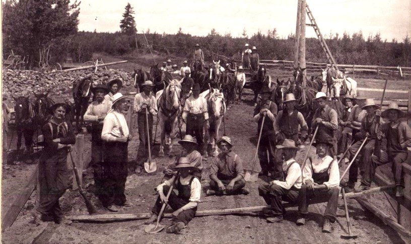
Today a provincial roadway and aboiteau divides Wallace Bay NWA into two roughly equal components of freshwater and saltwater wetlands. The aboiteau functions as a one-way tide gate, stopping the inflow of tidal waters from entering the predominantly freshwater wetlands west of the divide, while permitting the outflow of freshwater. The first structure at the aboiteau site, which was then known as “the narrows”, was built in 1838. Over the years, and as recently as 1984, major repairs and replacements have been necessary to maintain the tide gate. Starting in 1973 with the cooperation of Ducks Unlimited Canada (DUC), 138 ha of long-abandoned farmland, predominantly on the freshwater side of the aboiteau, was reverted to freshwater marsh through the building of dykes and water control structures (Ducks Unlimited Canada and Canadian Wildlife Service, 1989).
The tidal portion of the Wallace Bay channel provided the area’s inhabitants with fish and shellfish, principally smelt, gaspereau and oyster. Gaspereau and oyster are presently commercially harvested. There is a 2.2 ha aquaculture lease (site number 0331) within the Wallace Bay channel administered by the Nova Scotia Department of Fisheries and Aquaculture.
Most of the 134 ha of upland within the NWA, largely bordering the south side of the NWA, was cleared for farmland following the 1784 settlement of the Wallace Bay area. Traces of the locations of eight former homesteads, a store, and a mill site can be found within the boundary of the NWA (Brown 1973). All of these features were abandoned well before the establishment of the NWA.
1.3 Land ownership
The majority of the uplands and wetlands gazetted as the Wallace Bay NWA are owned by the Government of Canada. The property boundaries of these coastal parcels follow the mean high water mark (normal tide). Lands under tidal waters within the NWA are owned by the province of Nova Scotia.
The NWA includes 10 ha of agricultural upland that is maintained in pasture, hay, and grain crops by neighbouring farmers. This is a continuation of traditional land use and allows for the maintenance of an agroecosystem for the benefit of those species that utilize waste grain as well as for grassland nesting birds. These activities are authorized through permits issued under the authority of the Wildlife Area Regulations .
The federal government does not hold the sub-surface mineral rights for Wallace Bay NWA (Figure 6).
1.4 Facilities and infrastructure
There are no roads or buildings within Wallace Bay NWA. A public parking area and boat launch is maintained on the southwest side of the Aboiteau Road causeway, providing access to the freshwater impoundments and channel. The use of outboard motorboats less than 10.0 horsepower is allowed, and off-road vehicles are prohibited. Regular maintenance visits include site inspections and repairs and replacement of regulatory signage (including boundary, public notice, and 2’ x 4’ NWA identification signage) (Table 2).
The largest single infrastructure within the NWA is the system of dykes and control structures maintained by Ducks Unlimited Canada in cooperation with the Canadian Wildlife Service (Table 3).
| Type of Facility of Infrastructure | Approximate Size or Number | Responsibility Holder or Owner |
|---|---|---|
| Property boundary | 20.9 km | CWS - ECCC |
| Boundary signs | 300 | CWS - ECCC |
| NWA identification signs | 1 | CWS - ECCC |
| Public notice signs | 10 | CWS - ECCC |
| Trails (unimproved) | 3.7 km | CWS - ECCC |
| Foot bridges | 3 | CWS - ECCC |
| Boat landing | 1 | CWS - ECCC |
| Parking lot (1) | 900 m2 | CWS - ECCC |
| Maintenance access points | (2) | CWS - ECCC |
| Impoundments/projects (7)a | 186.5 ha | Ducks Unlimited Canada |
| Control structures | 7 | Ducks Unlimited Canada |
a Ducks Unlimited Canada and Canadian Wildlife Service
| Project Number | Project Name | Year Built | Size: (ha) | Level of Marsh (feet)b | Maximum Operating Level (feet)b | Normal Operating Level (feet)b |
|---|---|---|---|---|---|---|
| 6144 | 1 | 1973 | 52.6 | 0.2 | 4.0 | 1.7 |
| 6145 | 2A | 1973 | 44.5 | 0.2 | 2.8 | 1.2 |
| 6145 | 2B | 1973 (cross dyke 1979) | 8.9 | 0.3 | 2.7 | 2.7 |
| 6145 | 2C | 1973 (subdivided from 2A in 1988) | 9.7 | 0.3 | 2.8 | 1.1 |
| 6152 | 3A | 1974 | 18.2 | 3.2 | 5.5 | 3.9 |
| 6152 | 3B | 1978 | 4 | 3.6 | 5.5 | 5.3 |
| 6190 | Natural Marsh | 1977 | 48.6 | - | - | - |
| TOTAL | - | - | 186.5 | - | - | - |
b Canadian Geodetic Vertical Datum 1928 (CGVD28); elevation above sea level.