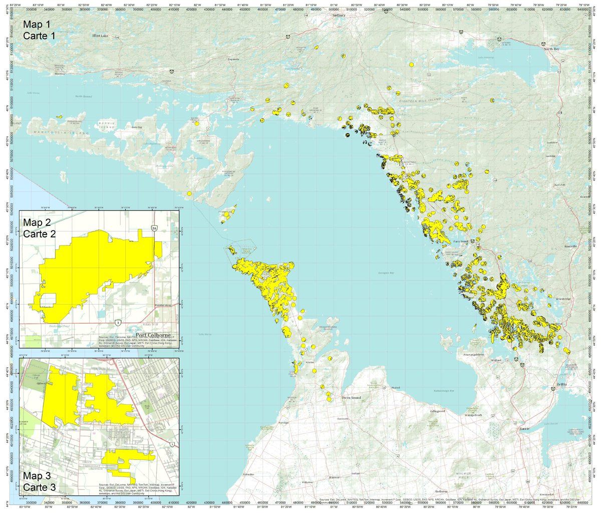
Massasauga in Ontario: critical habitat map
Massasauga (Sistrurus catenatus)
Areas Containing Critical Habitat
Ontario, Canada

Web Mercator Auxiliary Sphere
WGS 1984
1 : 500,000
Kilometres

Legend : Areas highlighted in yellow = Areas Containing Critical Habitat
Important Notice and Disclaimer
This map is created from a variety of public, private and 3rd party information sources:
- Extracted from: http://gotoarcgisonline.com/maps/World_Topo_Map Tuesday June 12th, 2012
- Sources: Esri, DeLorme, NAVTEQ, Tom Tom, Intermap, iPC, USGS, FAO, NPS, NRCAN, GeoBase, ICN, Kadaster NL, Ordnance Survey, Esri Japan, METI, Esri China (Hong Kong), and the GIS User Community.
The Government of Canada, Parks Canada Agency has made every effort to ensure the accuracy of the information depicted on this map. However, the Government of Canada, Parks Canada Agency cannot be held accountable for errors or omissions in the informatin displayed on this map.
Long description for map
For the Massasauga Rattlesnake, we considered critical habitat for the northern part of the species range as polygons with a 1.2 kilometre radius, based on the centroid of confirmed records of the species (2085 for Bruce Peninsula and 6726 for Eastern Georgian Bay.
For the southern populations, critical habitat was considered as the remaining areas with confirmed observations of Massasauga, and which continue to provide supporting habitat. The following parcels were identified:
- 277_3_1 Wainfleet Bog, straddling boundary of Wainfleet Township Municipality and City of Port Colborne, Niagara Regional Municipality, 2 kilometres from north shore of Lake Erie, southwestern Ontario.
- 277_3_2 Wainfleet Bog, City of Port Colborne, Niagara Regional Municipality, 5 kilometres from north shore of Lake Erie, southwestern Ontario.
- 277_4_1 LaSalle Woodlot, Town of LaSalle, Essex County, southwestern Ontario.
- 277_4_2 Spring Garden Natural Area, almost entirely City of Windsor, but some in Town of LaSalle, Essex County, southwestern Ontario.
- 277_4_3 Ojibway Provincial Nature Reserve, almost entirely City of Windsor, but some in Town of LaSalle, Essex County, southwestern Ontario