
Management Plan for the Threaded Vertigo (Nearctula sp.) in Canada - 2017 [Proposed]
Threaded Vertigo
- Part 1 - Federal Addition to the Management Plan for the Threaded Vertigo (Nearctula sp.) in British Columbia, prepared by Environment and Climate Change Canada
- Part 2 - Management Plan for Threaded Vertigo (Nearctula sp.) in British Columbia, prepared by the B.C. Ministry of Environment
- Document Information
- 1 COSEWIC ispecies assessment information
- 2 Species status information
- 3 Species information
- 4 Threats
- 5 Management goal and objectives
- 6 Approaches to meet objectives
- 7 Measuring progress
- 8 Effects on other species
- 9 References
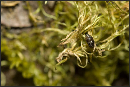
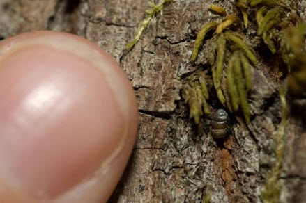
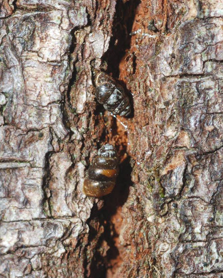
- Figure 1. Threaded Vertigo in situ on bigleaf maple bark.
- Figure 2. Threaded Vertigo in situ on bigleaf maple bark.
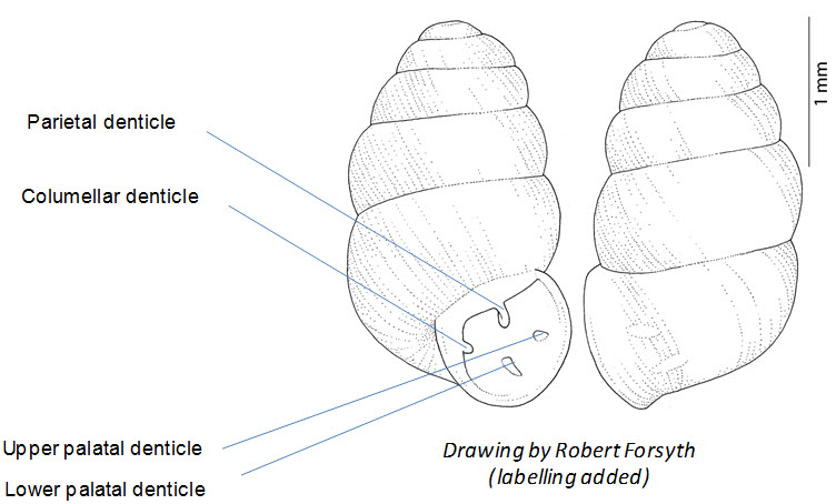
- Figure 3. Diagram of the shell of Threaded Vertigo, showing arrangement of apertural denticles.
- Figure 4. Threaded Vertigo distribution in Canada/North America (COSEWIC 2010).
- Figure 5. Threaded Vertigo distribution in British Columbia. Numbers correspond to sites listed in Table 1.
- Table 1. Status and description of Threaded Vertigo sites in British Columbia.
- Table 2. Summary of essential functions, features, and attributes of Threaded Vertigo habitat in British Columbia.
- Table 3. Threat classification table for Threaded Vertigo in British Columbia.
- Table 4. Existing mechanisms that afford habitat protection for Threaded Vertigo.
- Table 5. Recommended management actions for Threaded Vertigo.
- Appendix 1. Distribution records of Threaded Vertigo in Canada (FMNH = Field Museum of Natural History; RBCM = Royal British Columbia Museum).
- Appendix 2. Distribution of bigleaf maple in southwestern British Columbia (Source: COSEWIC 2010 [Figure 6].
Management Plan for the Threaded Vertigo (Nearctula sp.) in Canada - 2017 [Proposed]
Environment and Climate Change Canada. 2017. Management Plan for the Threaded Vertigo (Nearctula sp.) in Canada [Proposed]. Species at Risk Act Management Plan Series. Environment and Climate Change Canada, Ottawa. 2 parts, 4 pp. + 42 pp.
For copies of the management plan, or for additional information on species at risk, including the Committee on the Status of Endangered Wildlife in Canada (COSEWIC) Status Reports, residence descriptions, action plans, and other related recovery documents, please visit the Species at Risk (SAR) Public Registry.
Cover illustration: © Andy Teucher, British Columbia Ministry of Environment, Victoria, BC
Également disponible en français sous le titre
« Plan de gestion du vertigo à crêtes fines (Nearctula sp.) au Canada [Proposition] »
Content (excluding the illustrations) may be used without permission, with appropriate credit to the source.
Under the Accord for the Protection of Species at Risk (1996), the federal, provincial, and territorial governments agreed to work together on legislation, programs, and policies to protect wildlife species at risk throughout Canada.
In the spirit of cooperation of the Accord, the Government of British Columbia has given permission to the Government of Canada to adopt the Management Plan for the Threaded Vertigo (Nearctula sp.) in British Columbia (Part 2) under Section 69 of the Species at Risk Act (SARA). Environment and Climate Change Canada has included a federal addition (Part 1) which completes the SARA requirements for this management plan.
The federal management plan for the Threaded Vertigo in Canada consists of two parts:
Part 1 - Federal Addition to the Management Plan for the Threaded Vertigo (Nearctula sp.) in British Columbia, prepared by Environment and Climate change Canada.
Part 2 - Management Plan for Threaded Vertigo (Nearctula sp.) in British Columbia, prepared by the British Columbia Ministry of Environment.
The federal, provincial, and territorial government signatories under the Accord for the Protection of Species at Risk (1996) agreed to establish complementary legislation and programs that provide for effective protection of species at risk throughout Canada. Under the Species at Risk Act (S.C. 2002, c. 29) (SARA), the federal competent ministers are responsible for the preparation of management plans for listed species of special concern and are required to report on progress within five years after the publication of the final document on the SAR Public Registry.
The Minister of Environment and Climate Change is the competent minister under SARA for the Threaded Vertigo and has prepared the federal component of this management plan (Part 1), as per section 65 of SARA. To the extent possible, it has been prepared in cooperation with the Province of British Columbia as per section 66(1) of SARA. SARA section 69 allows the Minister to adopt all or part of an existing plan for the species if the Minister is of the opinion that an existing plan relating to wildlife species includes adequate measures for the conservation of the species. The Province of British Columbia provided the attached management plan for the Threaded Vertigo (Part 2) as science advice to the jurisdictions responsible for managing the species in British Columbia. It was prepared in cooperation with Environment and Climate Change Canada.
Success in the conservation of this species depends on the commitment and cooperation of many different constituencies that will be involved in implementing the directions set out in this plan and will not be achieved by Environment and Climate Change Canada or any other jurisdiction alone. All Canadians are invited to join in supporting and implementing this plan for the benefit of the Threaded Vertigo and Canadian society as a whole.
Implementation of this management plan is subject to appropriations, priorities, and budgetary constraints of the participating jurisdictions and organizations.
The following sections have been included to address specific requirements of the federal Species at Risk Act (SARA) that are not addressed in the Management Plan for the Threaded Vertigo (Nearctula sp.) in British Columbia (Part 2 of this document, referred to henceforth as “the provincial management plan”) and/or to provide updated or additional information.
Under SARA, general prohibitions regarding the protection of species and their habitat do not apply to species of special concern. Conservation measures in the provincial management plan dealing with the protection of individuals and their habitat are still adopted to guide conservation efforts but would not result in federal legal protection.
A strategic environmental assessment (SEA) is conducted on all SARA recovery planning documents, in accordance with the Cabinet Directive on the Environmental Assessment of Policy, Plan and Program Proposals. The purpose of a SEA is to incorporate environmental considerations into the development of public policies, plans, and program proposals to support environmentally sound decision-making and to evaluate whether the outcomes of a recovery planning document could affect any component of the environment or any of the Federal Sustainable Development Strategy's (FSDS) goals and targets.
Conservation planning is intended to benefit species at risk and biodiversity in general. However, it is recognized that implementation of management plans may also inadvertently lead to environmental effects beyond the intended benefits. The planning process based on national guidelines directly incorporates consideration of all environmental effects, with a particular focus on possible impacts upon non-target species or habitats. The results of the SEA are incorporated directly into the management plan itself, but are also summarized below in this statement.
The provincial management plan for the Threaded Vertigo contains a short section describing the effects of management activities on other species (i.e., Section 8). Environment and Climate Change Canada adopts this section of the provincial management plan as the statement on effects of management activities on the environment and other species. The distribution of Threaded Vertigo may overlap with that of other federally-listed species at risk occurring in coastal deciduous and mixed-wood forests (e.g., Blue-grey Taildropper (Prophysaon coeruleum), Dromedary Jumping-slug (Hemphillia dromedarius), Warty Jumping-slug (Hemphillia glandulosa), Oregon Forestsnail (Allogona townsendiana), Scouler's Corydalis (Corydalis scouleri) and Coastal Wood Fern (Dryopteris arguta)) that could be affected by management actions. Conservation planning activities for Threaded Vertigo will be implemented with consideration for all co-occurring species, with focus on species at risk, to avoid or minimize negative impacts to these species or their habitats. Some management actions for Threaded Vertigo (e.g., research and monitoring, habitat conservation, public education and mitigation about general threats to the species) may promote the conservation of other species at risk that overlap in distribution and rely on similar habitat attributes.
Management Plan for Threaded Vertigo (Nearctula sp.) in British Columbia
Prepared by British Columbia Ministry of Environment
British Columbia Ministry of Environment
November 2016
This series presents the management plans that are prepared as advice to the Province of British Columbia. Management plans are prepared in accordance with the priorities and management actions assigned under the British Columbia Conservation Framework. The Province prepares management plans for species that may be at risk of becoming endangered or threatened due to sensitivity to human activities or natural events.
A management plan identifies a set of coordinated conservation activities and land use measures needed to ensure, at a minimum, that the target species does not become threatened or endangered. A management plan summarizes the best available science-based information on biology and threats to inform the development of a management framework. Management plans set goals and objectives, and recommend approaches appropriate for species or ecosystem conservation.
Direction set in the management plan provides valuable information on threats and direction on conservation measures that may be used by individuals, communities, land users, conservationists, academics, and governments interested in species and ecosystem conservation.
To learn more about species at risk recovery planning in British Columbia, please visit the Ministry of Environment Recovery Planning webpage
B.C. Ministry of Environment. 2016. Management plan for Threaded Vertigo (Nearctula sp.) in British Columbia. B.C. Ministry of Environment, Victoria, BC. 42 pp.
Andy Teucher, British Columbia Ministry of Environment, Victoria, BC.
Additional copies can be downloaded from the B.C. Ministry of Environment Recovery Planning webpage
The British Columbia Ministry of Environment has prepared this management plan, as advice to the responsible jurisdictions and organizations that may be involved in managing the species.
This document identifies the management actions that are deemed necessary, based on the best available scientific and traditional information, to prevent Threaded Vertigo populations in British Columbia from becoming endangered or threatened. Management actions to achieve the goals and objectives identified herein are subject to the priorities and budgetary constraints of participatory agencies and organizations. These goals, objectives, and management approaches may be modified in the future to accommodate new objectives and findings.
The responsible jurisdictions, gastropod specialists, lands managers, and land owners have had an opportunity to review this document. However, this document does not necessarily represent the official positions of the agencies or the personal views of all individuals of the management team.
Success in the conservation of this species depends on the commitment and cooperation of many different constituencies that may be involved in implementing the directions set out in this management plan. The B.C. Ministry of Environment encourages all British Columbians to participate in the conservation of Threaded Vertigo.
This management plan was prepared by Jennifer Heron of the B.C. Ministry of Environment (ENV), Kristiina Ovaska (Biolinx Environmental Research), and Lennart Sopuck (Biolinx Environmental Research). Funding for this document was provided by Environment and Climate Change Canada, Canadian Wildlife Service, Pacific Region (ECCC-PAC), and the B.C. Ministry of Environment. Thank you to Lea Gelling and Dawn Marks (B.C. Conservation Data Centre) for assistance with element occurrence information and mapping. Jennifer Heron, Kristiina Ovaska, and Lennart Sopuck participated in the updated threats assessment. Thank you to Bruce Rea (B.C. Ministry of Forests, Lands and Natural Resource Operations), for creating the maps in this document. Brian Campbell and Véronique Lalande (ECCC-National Capital Region), Kella Sadler and Matt Huntley (ECCC-PAC), Peter Fielder (ENV), Jonathan Tillie (B.C. Ministry of Transportation and Infrastructure), Dave Trotter (B.C. Ministry of Agriculture), and Chris Pasztor (B.C. Ministry of Natural Gas Development) provided helpful review comments.
Jennifer Heron, B.C. Ministry of Environment, Vancouver, BC
Lennart Sopuck, Biolinx Environmental Research Ltd., Sidney, BC
Kristiina Ovaska, Biolinx Environmental Research Ltd., Sidney, BC
Trudy Chatwin, B.C. Ministry of Forests, Lands and Natural Resource Operations, Nanaimo, BC
Threaded Vertigo (Nearctula sp.) is a minute land snail in the family Vertiginidae. Snails in this family have high, columnar shells up to 3.5 mm in height at adulthood. The outer layer that covers the shell is dull dark brown and coarsely textured. In adult shells, four white tooth-like protuberances (denticles) are visible inside the shell when viewed from the opening (aperture). The shells need to be examined carefully for positive identification, which usually involves collection of a sample of specimens for microscopic examination.
Threaded Vertigo was assessed as Special Concern by the Committee on the Status of Endangered Wildlife in Canada (COSEWIC) and is listed on Schedule 1 of the federal Species at Risk Act (SARA). In British Columbia, Threaded Vertigo is ranked S2 (Imperiled) by the B.C. Conservation Data Centre and is on the provincial Red list. The B.C. Conservation Framework ranks Threaded Vertigo as a priority 2 under goal 3 (maintain the diversity of native species and ecosystems).
In British Columbia, Threaded Vertigo is at the northern extent of its range in western North America. It is found in lowland areas around the Strait of Georgia and on southern Vancouver Island and from southern Gulf Islands (Saturna Island and Saltspring Island). Most individuals live on the bark of bigleaf maple (Acer macrophyllum) trees. Undocumented sites are likely to exist on private properties and other unsurveyed areas within suitable bigleaf maple forest habitats. Threaded Vertigo appears to have a poor capacity for dispersal between trees and sites. The main threats are from removal of trees and habitat degradation, whether this be from urban expansion, roads and associated infrastructure, forestry, or agriculture.
The management goal is to maintain populations of Threaded Vertigo at all extant sites within the province, including any additional populations that may be identified in the future.
The population and distribution goal for Threaded Vertigo cannot be quantified at present because significant knowledge gaps exist relating to distribution and habitat requirements. The species may qualify for down-listing if: (1) threats to its habitats are managed with demonstrable effectiveness, and/or (2) a substantial number of new subpopulations are found and their habitats are secured.
The management objectives for Threaded Vertigo are:
- to secure protection Footnote1 (with no loss or degradation of habitat) for extant sites of Threaded Vertigo;
- to confirm the distribution of Threaded Vertigo within its range in British Columbia;
- to assess and mitigate threats to extant sites and, more broadly, to low-elevation, bigleaf maple-dominated stands within the range of Threaded Vertigo; and
- to address knowledge gaps, including, but not limited to: habitat requirements at the landscape, stand, and microhabitat scales; associations and roles within epiphytic communities; relationships with mosses and other organisms; and reproductive, and other life history features.
Recovery planning for Threaded Vertigo is concurrent with recovery planning approaches for species with similar habitats and threats. Because of the extensive knowledge gaps for this snail, most recovery planning activities focus on inventory, habitat information and mapping, and threat clarification.
i Committee on the Status of Endangered Wildlife in Canada.
- FRPA:iii No
- B.C. Wildlife Act:iv No
- SARA:v Schedule 1 - Special Concern
- OGAA:iii No
- B.C. Wildlife Act:iv No
- SARA:v Schedule 1 - Special Concern
- B.C. List: Blue
- B.C. Rank: S3 (2015)
- National Rank: N2(2013)
- Global Rank: G3G5 (2006)
- Other Subnational Ranks:vii California (SNR), Oregon (SNR), Washington (SNR)
- Data source: B.C. Conservation Data Centre (2016) unless otherwise noted.
- No = not listed in one of the categories of wildlife that requires special management attention to address the impacts of forest and range activities on Crown land under the Forest and Range Practices Act (FRPA; Province of British Columbia 2002) and/or the impacts of oil and gas activities on Crown land under the Oil and Gas Activities Act (OGAA; Province of British Columbia 2008).
- No = not designated as wildlife under the British Columbia Wildlife Act (Province of British Columbia 1982).
- No = not on any Schedules under the Species at Risk Act (SARA; Government of Canada 2002).
- S = subnational; N = national; G = global; X = presumed extirpated; H = possibly extirpated; 1 = critically imperiled; 2 = imperiled; 3 = special concern, vulnerable to extirpation or extinction; 4 = apparently secure; 5 = demonstrably widespread, abundant, and secure; NA = not applicable; NR = unranked; U = unrankable.
- Data source: NatureServe (2016).
- Data source: B.C. Ministry of Environment (2009).
- Six-level scale: Priority 1 (highest priority) through to Priority 6 (lowest priority).
Threaded Vertigo (Nearctula sp.) is a minute land snail in the family Vertiginidae. While the validity of the species is not in question, taxonomic complications and revisions have left the species without a formal scientific name (see COSEWIC 2010 for the background on the species' taxonomy). This situation has not changed since the COSEWIC 2010 status report, and this management plan follows the nomenclature by Forsyth (2004) and COSEWIC (2010).
Snails in the family Vertiginidae are very small, with high, columnar shells. Threaded Vertigo can be identified based on its shell characteristics. Possessing a shell of up to 3.5 mm in height at adulthood, Threaded Vertigo is a veritable giant among vertiginids (members of the family Vertiginidae) and the largest of member of this group in British Columbia. The outer layer that covers the shell is dull dark brown and coarsely textured (Figure 1 and Figure 2). In adult shells, four white tooth-like protuberances (denticles) are visible inside the shell when viewed from the shell opening (aperture); the slightly twisted, long and curved denticle on the upper surface of the shell opening is the largest (Figure 3). The denticles are lacking or poorly developed in immature specimens. Several other smaller vertiginid snails occur within the range of Threaded Vertigo and also have apertural denticles. The shells need to be examined carefully for positive identification, which usually involves collection of a sample of specimens for microscopic examination.
The life history of Threaded Vertigo is virtually unknown but probably resembles that of other species of vertiginid snails (see Habitat and Biological Needs, Section 3.3). Threaded Vertigo is hermaphroditic, possessing both female and male reproductive organs, but separate individuals probably mate and exchange sperm. It is unknown whether the species is capable of self-fertilization. Clutch size is also unknown. Adult snails have been recorded in both spring and fall in British Columbia, suggesting that at least some adults survive the winter. The snails probably hibernate during cold periods in winter and aestivate during dry, warm periods in summer. Generation time is probably about 1 year.
The global distribution of Threaded Vertigo is confined to western North America and extends from southwestern British Columbia southward to west-central California (Figure 4). Approximately 7% of the global distribution of the species is in Canada (COSEWIC 2010) and surveys since the COSEWIC (2010) assessment have not increased the species geographic range in Canada. Scattered records occur from throughout the northern portion of the species’ range in western Washington, Oregon, and British Columbia (COSEWIC 2010). The distributional boundaries in the east are poorly known.
In British Columbia, the species is known from Vancouver Island, from the mainland Pacific coast north of Vancouver referred to as the “Sunshine Coast,” which includes the Sechelt Peninsula, and from the southern Gulf Islands (Saturna Island and Saltspring Island) (Figure 5). The oldest records are from mid-1890s to early 1920s from the Victoria, Nanaimo, and Duncan areas on Vancouver Island (COSEWIC 2010) (Table 1). Forty-five recent (since 1984) records of the species are known from 29 sites. Records closer than 1 km were grouped together and are considered a single site based on the continuity of the habitat within the polygon and the inability of the snail to disperse between sites due to a physical barrier (Table 1; see Appendix 1 for the records). Physical barriers include unsuitable habitats such as sandy areas, large water bodies and developed areas including highways. Of the 29 sites, 17 (sites 1–17 in Table 1) are from the east and south coast of Vancouver Island, mostly within the Capital Regional District, four (sites 18–21) are from the Sunshine Coast, seven are from Saltspring Island (sites 22–28), and one (site 29) is from Saturna Island. Undocumented sites likely exist on private properties and/or other unsurveyed areas within the species’ current distribution, based on availability of suitable habitat and continued finding of new sites.
No gene flow among snails in the broad geographic areas (Vancouver Island, Sunshine Coast, Gulf Islands) is expected at present, as open expanses of water form barriers for dispersal. Within each of these three geographic areas, there is likely no or limited gene flow, as evidenced by the scattered records within widely separated sites, combined with human-caused habitat fragmentation, in the intervening areas. Cordeiro (2004) suggested that a distance of 1 km be used to delineate terrestrial snail sites, based on their generally poor dispersal abilities. Passive dispersal of Threaded Vertigo by wind or water during storms is a possibility among sites that are close together, but it is undocumented and unlikely over larger distances (e.g., > 1 km). There are no known or suspected animal vectors that could aid in dispersal. Survey effort of suitable habitats throughout the range of Threaded Vertigo is incomplete, making the delineation of these possible subpopulations unfeasible at this time.
No information is available on site or province-wide population or distribution trends of Threaded Vertigo for British Columbia or elsewhere within the species’ global range. Population declines of the species can be inferred from habitat loss and fragmentation primarily related to urban and rural development and land clearing on eastern and southern Vancouver Island, the Sunshine Coast, and the Gulf Islands, which continue today concomitantly with increasing human population. As part of field verification surveys for the COSEWIC (2010) status report, the presence of Threaded Vertigo was confirmed in the vicinity of two previous records where habitat remained intact (Egmont on the Sunshine Coast; Rocky Point on Vancouver Island), but not at three other previous records on Vancouver Island that were revisited and where little suitable forested habitat remained (Quamichan Lake; Departure Bay; Union Bay). In total, these surveys targeting Threaded Vertigo habitats recorded the species at 9 of 17 sites surveyed, two of which were previously known and seven of which were new. On the Sunshine Coast, the species was found at all four sites surveyed (one previously known and three new sites). On Vancouver Island, the species was found at three new sites within the Capital Regional District and at Rosewall Creek, between Union Bay and Horne Lake, filling in a large (33 km) distribution gap on Vancouver Island. The wide spread of recent records suggests that the species continues to persist across much of its known provincial range in areas where suitable forest habitat remains; additional sites are likely to be found with increased survey effort.
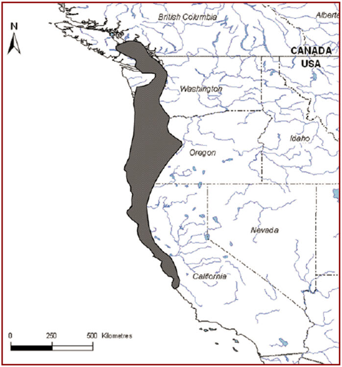
Long description for Figure 4
A map of the west coast of the US and Canada shows that Threaded Vertigo habitat spans from central California to southern British Columbia along the pacific coast. Within California, the band is relatively narrow along the coast. In Oregon and Washington State the distribution extends inland further. In Canada, the distribution exists on the southeastern region of Vancouver Island.
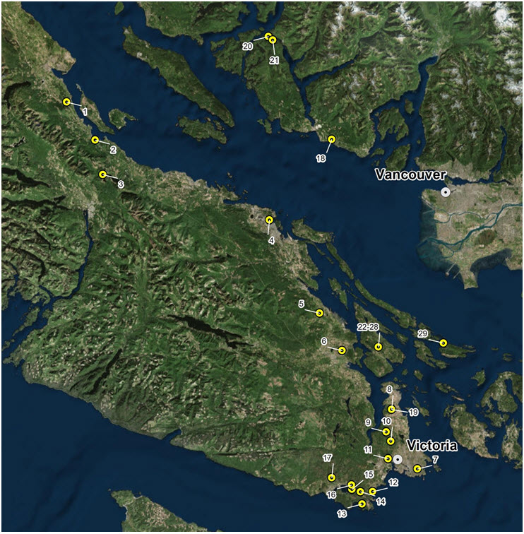
Long description for Figure 5
A map of the southeastern region of Vancouver Island and the mainland north of Vancouver shows that the highest concentration of Threaded Vertigo distribution lies clustered around the Victoria region, with a dozen sites. 3 sites occur on the mainland near the coast near Davis Bay and Eggmont. 3 sites also occur south of the Comox area on Vancouver Island.
| Site # | Site description | No. records | No. snails (total) | Year(s) | Land ownership | Population status a |
|---|---|---|---|---|---|---|
| 1 | Vancouver Island: Union Bay | 1 | 3 | 1996 | Private | Unknown; not found during survey in 2008 (COSEWIC 2010). |
| 2 | Vancouver Island: Rosewall Creek, south of Courtenay | 1 | 15 | 2008 | Provincial Crown (provincial park) | Extant |
| 3 | Vancouver Island: Lake Horne (sites 27 & 28) | 1 | 5 | 1984 | Presumably Provincial Crown (provincial park) | Unknown; not found during survey in 2008 (COSEWIC 2010). |
| 4 | Vancouver Island: “Wellington (Departure Bay)” | 1 | 17 | 1890–1920 | Unknown, likely private | Historical |
| 5 | Vancouver Island: Chemainus Lake (west side) | 1 | 2 | 1999 | Private forestry | Extant |
| 6 | Vancouver Island: “Quamichan Lake, Duncan” | 1 | 6 | 1890–1920 | Unknown, likely private | Historical |
| 7 | Vancouver Island: “Victoria” (no detailed location) | 1 | 11 | 1890–1920 | Unknown, likely private | Historical |
| 8 | Vancouver Island: John Dean Provincial Park, North Saanich | 1 | 13 | 2008 | Provincial Crown (provincial park) | Extant |
| 9 | Vancouver Island: Heals Rifle Range | 2 | 5 | 2008 | Federal (Department of National Defense) | Extant |
| 10 | Vancouver Island: Prospect Lake (Goward Road) | 1 | 1 | 2010 | Private (rural residential) | Extant |
| 11 | Vancouver Island: Thetis Lake Regional Park | 1 | 1 | 2008 | Private (Capital Regional District–local government) | Extant |
| 12 | Vancouver Island: Devonian Regional Park, Metchosin | - | 10 | 2008 | Private (Capital Regional District–local government) | Extant |
| 13 | Vancouver Island: Rocky Point, Metchosin (near Beecher Bay) | 5 | 11 | 2002, 2008 | Federal (Department of National Defense) | Extant |
| 14 | Vancouver Island: Metchosin | 1 | 3 | 2008 | Private (Capital Regional District–local government) or private (47 m W of trail) | Extant |
| 15 | Vancouver Island: Metchosin (Galloping Goose Trail near Gillespie Road) | - | 5 | 2008 | Private (Capital Regional District–local government) | Extant |
| 16 | Vancouver Island: Sooke | - | 11 | 2008 | Private (Capital Regional District–local government) | Extant |
| 17 | Vancouver Island: Galloping Goose Trail at Sooke River | - | 9 | 2008 | Private (Capital Regional District–local government) | Extant |
| 18 | Sunshine Coast: Robert's Creek Provincial Park, ca. 7 km SE of Sechelt | 1 | 5 | 2008 | Provincial Crown (provincial park) | Extant |
| 19 | Sunshine Coast: Suncoaster Trail near Ruby Lake, S of Egmont | 1 | 8 | 2008 | Unknown, likely private | Extant |
| 20 | Sechelt Peninsula: near Egmont | 2 | 7 | 1996, 2008 | Private (possibly municipal) | Extant |
| 21 | Sunshine Coast: Access road to Skookumchuk Narrows Provincial Park | 1 | 7 | 2008 | Unknown, likely private | Extant |
| 22 | Salt Spring Island: Cusheon Lake | 3 | 17 | 2011 | Provincial Crown | Extant |
| 23 | Salt Spring Island: Duck Creek Park | 2 | 5 | 2010, 2012 | Private; regional park, managed by PARC | Extant |
| 24 | Salt Spring Island: Mouat Regional Park | 2 | 12 | 2009, 2010 | Private; regional park, managed by PARC | Extant |
| 25 | Salt Spring Island: Musgrave triangle | 1 | 1 | 2013 | Provincial Crown | Extant |
| 26 | Salt Spring Island: Reginald Hill Community Park | 2 | 12 | 2010 | Private; regional park, managed by PARC | Extant |
| 27 | Salt Spring Island: Road easement, outside Tuam Special Management Area | 1 | 2 | 2011 | Road easement, outside Tuam Special Management Area | Extant |
| 28 | Salt Spring Island: Tuam Special Management Area | 5 | 11 | 2011 | Provincial Crown (special management area) | Extant |
| 29 | Saturna Island: Winter Cove, Gulf Islands National Park Reserve | 1 | 12 | 2009 | Federal (national park) | Extant |
a Extant: occurrence has been recently (within 10 years) verified as still existing. Historical: used for occurrences where habitat has been extensively modified and recent surveys have failed to find the species; generally these records are > 20 years old.
The habitat needs of the Threaded Vertigo snail are described at a larger, ecosystem or stand scale (deciduous and mixed-wood forest and riparian areas) and at a smaller scale (microsite and tree habitat). Different life stages require slightly different habitat requirements (Table 5), although little information is available on the details of these habitat requirements. As with other terrestrial gastropods in northern climates, Threaded Vertigo likely hibernates during cold winter months and aestivates during hot and dry summer months, perhaps as early as June (COSEWIC 2010). Hibernation and aestivation probably occurs in protected microsites, such as in crevices under bark of trees, or within thick moss mats or epiphytic vegetation: the same habitats as the snails use year-round.
3.3.1 Habitat
Deciduous and mixed-wood forest and riparian areas
In British Columbia, Threaded Vertigo has been recorded from moist low-elevation (< 200 m above sea level [asl]) deciduous and mixed-wood forests within the Coastal Douglas-fir and Coastal Western Hemlock biogeoclimatic zones (COSEWIC 2010; see Meidinger and Pojar 1991). Stands in which the species is found usually include a large component of bigleaf maple (Acer macrophyllum); alders (Alnus sp.) or cottonwoods (Populus sp.) may also be present. An understory of sword fern (Polystichum munitum), salmonberry (Rubus spectabilis), and other shrubs and herbs characteristic of moist, rich sites and riparian areas is often present. Older riparian forests with large bigleaf maple appear to be important for the snails, providing suitable moist shelter sites on the deeply furrowed bark of the standing maple trees.
High-quality bigleaf maple habitat may be more limiting than it would appear from the overall distribution of the trees throughout the province. Although bigleaf maples have a relatively wide distribution in southwestern British Columbia at latitudes below 51°N, the dense stands in which this species occurs encompasses more than 5% of the stand are restricted to a narrow belt along the southeast coast of Vancouver Island and the adjacent mainland coast (Appendix 2). Dense stands provide opportunities for the snails to move to and populate adjacent trees, whereas stands with scattered maples or other suitable deciduous trees may not support viable populations; however, no data are available to substantiate this.
Microsite and tree habitat
Threaded Vertigo is largely arboreal, inhabiting furrows on bark in bigleaf maple trunks and occasionally trunks of other deciduous trees such as alders and cottonwoods. For logistical reasons, most observations are from the lower portion of the tree trunks; however, one observation is recorded at an 18–21 m height on the trunk of a newly fallen bigleaf maple (L. Matthias, pers. comm., 2013). The snails are occasionally found on sword fern fronds or within the leaf litter, and may also occur on branches of bushes or small trees, as reported in Oregon (Frest and Johannes 1995). Whether they regularly occur in the litter or understory vegetation in the province is unknown.
| Life stage | Functionb | Feature(s)c | Attributesd |
|---|---|---|---|
| Eggs | Incubation | Unknown but likely a crack or furrow in bark of a large bigleaf maple or other deciduous tree. | High humidity and refuge from predators, such as provided by crevices and cracks on moss-covered limbs and trunk of large bigleaf maples. |
| Juvenile and adults snails | Feeding/foraging and overwintering | Tree trunks and limbs covered with a thick layer of mosses and lichens. Leaf litter of bigleaf maple in moist depressions (secondary). | High humidity and refuge from predators; abundance of older deciduous trees with a large component of epiphytes and other mossy habitat on the trunks. |
| Adult snails | Mating, egg laying | Moist tree trunks and limbs covered with a thick epiphytic moss layer. | Abundance of older deciduous trees with a large component of epiphytes and other mossy habitat on the trunks. |
| Juvenile and adults snails | Dispersal | Same as for foraging | High density of suitable large deciduous trees (e.g., stands in which bigleaf maples compose more than 5% of the stand); high moisture as in riparian habitats. |
b Function: a life-cycle process of the species (e.g., include either animal or plant examples: spawning, breeding, denning, nursery, rearing, feeding/foraging and migration; flowering, fruiting, seed dispersing, germinating, seedling development).
c Feature: the essential structural components of the habitat required by the species.
d Attribute: the building blocks or measurable characteristics of a feature.
Threaded Vertigo contributes to the biodiversity of the complex and poorly known arboreal plant and animal communities supported by large bigleaf maples (COSEWIC 2010). These unique communities include epiphytic mosses, liverworts, lichens, ferns, and other vascular plants that grow on limbs, trunks, and boles of old maples (Peterson et al. 1999). Epiphytes, in turn, enhance conditions for other organisms, from fungi and invertebrates to birds and mammals. The role of Threaded Vertigo in these communities and its relationships with other organisms are presently unknown.
Limiting factors are generally not human-induced and include characteristics that make the species less likely to respond to management and conservation efforts. For Threaded Vertigo, these characteristics include: poor dispersal ability, patchy distribution, presence at the northernmost range extent, and narrow habitat requirements.
3.5.1 Poor dispersal ability
Threaded Vertigo is a minute forest snail with poor dispersal ability, as reported for land snails in general (Cordeiro 2004). The heavily fragmented, low-elevation deciduous forests within the species’ distribution in the province severely limit its natural dispersal. Areas with high densities of bigleaf maples, in particular, are restricted to a small band within the populated and human-modified part of the west coast (COSEWIC 2010).
3.5.2 Patchy distribution
Surveys indicate that Threaded Vertigo is distributed patchily both among and within stands. Where the snail occurs, it may be found only within certain trees (Ovaska and Sopuck 2008; COSEWIC 2010). Whether patchy distribution pattern of snails within stands is related to some characteristics of the trees or stochastic factors is unknown. Snails that occur within sites that are small habitat patches are vulnerable to extirpation. The minimum abundance necessary to maintain a population at a site or a microsite (e.g., individual trees) is also unknown.
3.5.3 Northernmost extent of global range
Threaded Vertigo is at the northernmost extent of its global range in southwestern British Columbia. Populations at the extremities of their distribution may possess unique adaptations but may also be vulnerable to extreme weather events (such as prolonged cold periods in winter) within their present range. Cold winters probably also limit the expansion of their distribution northwards and eastwards on the mainland.
3.5.4 Narrow habitat requirements (high moisture)
Threaded Vertigo is an associate of older, low-elevation deciduous forests, with well-developed and dense understory or epiphytic vegetation that provides moist microhabitat necessary to maintain high humidity. Suitable microhabitat offers protection against daily or seasonal variations in temperature and water availability (as summarized in Prior 1985). Soil moisture and understory vegetation, which allows for the retention of moisture and availability of shelter, contribute to protective cover in times of drought and relative humidity at a location (numerous studies summarized in Prior 1985).
The physiology and activity patterns of gastropods inherently make them susceptible to continuous water loss through dehydration. All gastropods deposit a dilute mucous trail and experience constant evaporative water loss through the lung surface and integument. Snails make mucus trails upon which to move from place to place, and high humidity and moisture allow the production of slime. Snails are also known to follow the same slime trails, both of their own and other snail trails. High humidity and moisture allow these trails to persist. The physiology and apparent requirement for high moisture may make the snail inherently susceptible to dehydration and limit the habitats and trees that it can occupy. Numerous ecological and physiological studies show a relationship between varying body temperature hydration on locomotor activity (Machin 1975; Burton 1983; Riddle 1983; and Martin 1983 as cited in Prior 1985). In addition, the fungal food sources a snail likely consumes also require high moisture and humidity.
Threats are defined as the proximate activities or processes that have caused, are causing, or may cause in the future the destruction, degradation, and/or impairment of the entity being assessed (population, species, community, or ecosystem) in the area of interest (global, national, or subnational) (adapted from Salafsky et al. 2008). For purposes of threat assessment, only present and future threats are considered. Footnote2 Threats presented here do not include limiting factors, Footnote3 which are presented in Section 3.5.
For the most part, threats are related to human activities, but they can also be natural. The impact of human activity may be direct (e.g., destruction of habitat) or indirect (e.g., introduction of invasive species). Effects of natural phenomena (e.g., fire, flooding) may be especially important when the species is concentrated in one location or has few occurrences, which may be a result of human activity (Master et al. 2012). As such, natural phenomena are included in the definition of a threat, though they should be considered cautiously. These stochastic events should only be considered a threat if a species or habitat is damaged from other threats and has lost its ability to recover. In such cases, the effect on the population would be disproportionately large compared to the effect experienced historically (Salafsky et al. 2008).
The threat classification below is based on the IUCN–CMP (World Conservation Union–Conservation Measures Partnership) unified threats classification system and is consistent with methods used by the B.C. Conservation Data Centre. For a detailed description of the threat classification system, see the Open Standards website (Open Standards 2014). Threats may be observed, inferred, or projected to occur in the near term. Threats are characterized here in terms of scope, severity, and timing. Threat “impact” is calculated from scope and severity. For information on how the values are assigned, see Master et al. (2012) and table footnotes for details. Threats for Threaded Vertigo were assessed for the known extent of the species in the entire province (Table 3). This approach was taken because survey effort has been limited and more occurrences in suitable habitats are likely; however, threats to specific known sites were used as guidance, where applicable.
| Threat# e | Threat description | Impact f | Scope g | Severity h | Timing i | Sites (see Appendix 1 |
|---|---|---|---|---|---|---|
| 1 | Residential & commercial development | Low | Small | Extreme-Serious | High | - |
| 1.1 | Housing & urban areas | Low | Small | Extreme-Serious | High | The threat applies to at least 10 known sites or their vicinity (numbers as per Table 1): 1, 4 (historical), 6 (historical), 7 (historical), 10, 14, 15, 16, 17, 27) and to other suitable habitats across the species' known range. |
| 1.2 | Commercial & industrial areas | Negligible | Negligible | Extreme | High | Within the species' known range, applicable to suitable habitat near urban centres. |
| 1.3 | Tourism & recreation areas | Low | Small | Slight | High | 14 known sites are in national, regional, or municipal parks, and trail building and infrastructure development could happen, but no specific plans are known. Applicable sites include 8, 11, 12, 14, 15, 16, 17, 18, 19, 23, 24, 25, 26, and 29. |
| 2 | Agriculture & aquaculture | Negligible | Negligible | Serious | High | - |
| 2.1 | Annual & perennial non-timber crops | Negligible | Negligible | Serious | High | Applicable to suitable habitat within species' known range |
| 2.3 | Livestock farming & ranching | Negligible | Negligible | Serious | High | Applicable to suitable habitat within the species' known range. |
| 3 | Energy production & mining | Negligible | Negligible | Extreme | High | - |
| 3.2 | Mining & quarrying | Negligible | Negligible | Extreme | High | Applicable to suitable habitat within the species' known range. |
| 4 | Transportation & service corridors | Low | Small | Slight | High | - |
| 4.1 | Roads & railroads | Low | Small | Slight | High | New roads (within unsurveyed habitat) or expansion of existing roads are associated with urban expansion (see 1.1 & 1.2) and logging (see 5.3). Potential for roadside maintenance at sites 4, 5, 6, 20, 23, 26. |
| 5 | Biological resource use | Low | Small | Serious | High | - |
| 5.3 | Logging & wood harvesting | Low | Small | Serious | High | The threat applies to known 4 sites and their vicinity (numbers as per Table 1): 5, 19, 20, 21, as well as to other suitable habitat within the species' known range. |
| 6 | Human intrusions & disturbance | Negligible | Large | Negligible | High | - |
| 6.1 | Recreational activities | Negligible | Large | Negligible | High | 14 sites are in national, regional, or municipal parks (8, 11, 12, 14, 15, 16, 17, 18, 19, 23, 24, 25, 26, 29). |
| 6.2 | War, civil unrest & military exercises | Negligible | Small | Negligible | High | Species occurs on 2 military ranges: 13 (Rocky Point) and 9 (Heals Rifle Range). |
| 7 | Natural system modifications | Unknown | Pervasive | Unknown | High | - |
| 7.1 | Fire & fire suppression | Unknown | Pervasive | Unknown | High | Applicable across all extant sites and other suitable habitat within the species' known range. |
| 8 | Invasive & other problematic species & genes | Unknown | Pervasive | Unknown | High | - |
| 8.1 | Invasive non-native/alien species | Unknown | Pervasive | Unknown | High | Applicable across all extant sites and other suitable habitat within the species' known range. |
| 9 | Pollution | Negligible | Negligible | Unknown | Moderate | - |
| 9.3 | Agricultural & forestry effluents | Negligible | Negligible | Unknown | Moderate | 2–4 sites (15, 17, and perhaps 20 and 22), and other suitable habitat within the species' known range. |
| 11 | Climate change & severe weather | Unknown | Pervasive | Unknown | Moderate | - |
| 11.1 | Habitat shifting & alteration | Unknown | Pervasive | Unknown | Moderate–Low | Applicable across all extant sites and other suitable habitat within the species' known range. |
| 11.2 | Droughts | Unknown | Pervasive | Unknown | High | Applicable across all extant sites and other suitable habitat within the species' known range. |
e Threat numbers are provided for Level 1 threats (i.e., whole numbers) and Level 2 threats (i.e., numbers with decimals).
f Impact – The degree to which a species is observed, inferred, or suspected to be directly or indirectly threatened in the area of interest. The impact of each threat is based on severity and scope rating and considers only present and future threats. Threat impact reflects a reduction of a species population. The median rate of population reduction for each combination of scope and severity corresponds to the following classes of threat impact: Very High (75% declines), High (40%), Medium (15%), and Low (3%). Unknown: used when impact cannot be determined (e.g., if values for either scope or severity are unknown); Not Calculated: impact not calculated as threat is outside the assessment time (e.g., timing is insignificant/negligible [past threat] or low [possible threat in long term]); Negligible: when scope or severity is negligible; Not a Threat: when severity is scored as neutral or potential benefit.
g Scope – Proportion of the species that can reasonably be expected to be affected by the threat within 10 years. Usually measured as a proportion of the species' population in the area of interest. (Pervasive = 71–100%; Large = 31–70%; Restricted = 11–30%; Small = 1–10%; Negligible < 1%).
h Severity – Within the scope, the level of damage to the species from the threat that can reasonably be expected to be affected by the threat within a 10-year or 3-generation timeframe. For this species a 10-year time frame was used. Severity is usually measured as the degree of reduction of the species' population. (Extreme = 71–100%; Serious = 31–70%; Moderate = 11–30%; Slight = 1–10%; Negligible < 1%; Neutral or Potential Benefit ≥ 0%).
i Timing – High = continuing; Moderate = only in the future (could happen in the short term [< 10 years or 3 generations]) or now suspended (could come back in the short term); Low = only in the future (could happen in the long term) or now suspended (could come back in the long term); Insignificant/Negligible = only in the past and unlikely to return, or no direct effect but limiting.
Many Threaded Vertigo sites are within remnants of lowland bigleaf maple deciduous and mixed-wood forest. Threaded Vertigo has poor dispersal abilities and, as a result, forest fragmentation has led to further isolation and impairment of gene flow across the landscape. The snails have been found in small habitat patches, but the long-term viability of such populations is unknown. If a population within an isolated habitat patch was to experience a catastrophic event such as a fire or severe drought, it would be vulnerable to extirpation.
The overall, province-wide threat impact for this species is Low. Footnote4 This overall threat considers the cumulative impacts of multiple threats. Primary threats include residential and commercial development (rated as Medium impact) and biological resource use (rated as Low impact). Impacts currently considered negligible were included for future reference, and those considered Unknown were highlighted for future investigation and study. Threats are discussed below under their Level 1 headings, separated into two subsections: (1) those Level 1 threats having Medium or Low impacts, and (2) those with impacts that are Negligible or Unknown.
Threaded Vertigo likely has a short generation time of 1–2 years, and thus a 10-year time frame was used in determining severity scores. Threats were assessed for the entire distribution of the species in Canada (rather than focusing solely on known sites) because survey coverage is incomplete and more occurrences are likely in all broad areas where the species occurs (Vancouver Island, Gulf Islands, and Sunshine Coast) based on habitat suitability and the number of recent records in areas already searched.
4.2.1 Level 1 threats with low impacts
Threat 1. Residential & commercial development
1.1 Housing & urban areas and 1.2 Commercial & industrial areas
Urban expansion and associated habitat loss and fragmentation are ongoing threats to lowland deciduous and mixed-wood forests occupied by Threaded Vertigo, the distribution of which coincides with populated areas in southwestern British Columbia. Although many habitats have already been modified or lost, especially within the Capital Regional District, new subdivision creation and intensification of development in rural areas continues. Further habitat loss is expected concomitantly with human population growth, especially near large urban centres of Vancouver and Victoria. Many of the known sites are in parks or protected areas, whereas most of the suitable, largely unsurveyed habitat is on private lands.
The potential exists for the development of private properties within the Greater Victoria area, southeastern Vancouver Island, Sunshine Coast, southern Gulf Islands (Saltspring Island, Saturna Island). The development pressure in these areas is variable and may result in the subdivision of lowland forest into rural lots (on the Sunshine Coast and southeastern Vancouver Island) or further subdivision of existing lots into smaller lot sizes. It also includes localized threats from building or expanding individual houses on existing rural lots, which are unlikely to be subdivided. This threat applies to much potential lowland bigleaf maple forest habitat. Severity is Serious-Extreme because of development uncertainty, and the snails may exist in remnant tree patches within rural developments and larger bigleaf maple trees may remain standing around these developments, especially those on the Sunshine Coast and Gulf Islands. The threat potentially applies to at least 10 of 29 known sites (see Table 1 for sites) and the vicinity, but immediate plans for housing developments are not known.
1.3 Tourism & recreational areas
A minor contributor to this main threat category is the construction and upgrading of trails and infrastructure in parks and recreational areas, which is scored Small in scope and Slight in severity; however, such activities could have local impacts from habitat loss and edge effects, leading to desiccation. This habitat loss leads to opening of the forest and drying of the habitat, resulting in less humidity for snail movement and fungal (food) growth. Many known sites (14 of 29) are in parks, where trail building, or infrastructure development or replacement, could occur, but no information is available on such plans.
Threat 4. Transportation & service corridors
4.1 Roads & railroads
The entire Canadian range of Threaded Vertigo is fragmented with a network of roads that dissect habitats, although most of these roads are from past development. Urban expansion is associated with the construction of new roads (accounted for in Threat 1.1) and new logging roads also continue to be built where the species' distribution overlaps with forestry lands on Vancouver Island and the Sunshine Coast. The impacts to the snails are from loss of habitat by removal of trees for roadside maintenance, such as land clearing (e.g., for vehicle pull-outs) leading to fragmentation of habitat and possible isolation of snails distributed throughout a site and edge effects, resulting in drier conditions that reduce habitat quality. At least six (6/29=20%) sites have the potential for roadside expansion and clearing although these activities are not likely to occur annually. The extent of these activities are limited and at the edge of the habitat affected thus the Scope is Small and the Severity is Slight. This species is minute and primarily arboreal; roadkill is not considered a threat to this species.
Threat 5. Biological resource use
5.3 Logging & wood harvesting
Commercial logging occurs mainly on private forestry lands on southeastern Vancouver Island north of the Capital Regional District and on private and provincial lands on the Sunshine Coast, but firewood cutting and small-scale tree removal potentially occur throughout the species' range, including rural residential lots. Although bigleaf maples are not usually commercially harvested and are sometimes left standing, they may be damaged during forestry operations. Furthermore, opening up the stand creates drier conditions for the snails, leading to desiccation. Much tree removal on private lands is for activities such as agriculture or residential development (covered under other threats). Conversion of riparian hardwood stands to conifers may occur as part of forestry activities or aquatic habitat restoration, and also is a potential threat to Threaded Vertigo (COSEWIC 2010). The scope was scored as Small because much of the distribution of the species is outside forestry lands; it was not possible to estimate the percentage of land base expected to be subjected to logging within the next 10 years, but it is most likely less than 10%. The severity was scored as Low. Although the snails may persist in remnant tree patches and riparian areas within cutblocks, these habitats would be subject to edge effects and may not support viable populations over the long term. Threaded Vertigo has been observed in older tree patches within residential housing areas (e.g., site 15).
4.2.2 Level 1 threats with negligible or unknown impacts
Threat 2. Agriculture (Negligible impact)
2.1 Annual & perennial non-timber crops, and 2.3 Livestock farming & ranching
Hobby farms are expanding within the range of Threaded Vertigo and may include tree removal and conversion of land to agricultural activities, pastures, or livestock; however, these activities are expected to affect less than 1% of Threaded Vertigo habitat, resulting in a Negligible impact rating.
Threat 3. Energy production & mining (Negligible impact )
3.2 Mining & quarrying
Habitat loss may occur where borrow pits are created for gravel extraction for new roads and housing developments; however, this activity is expected to affect less than 1% of Threaded Vertigo habitats, resulting in a Negligible impact rating.
Threat 6. Human intrusions & disturbance (Negligible impact)
6.1 Recreational activities
Many known Threaded Vertigo sites are in multi-purpose parks that receive intensive recreational use. Recreational activities include camping, hiking, horseback riding, and bicycle traffic; unauthorized use of all-terrain vehicles and off-trail biking occurs in some parks. Some parks offer off-leash dog parks (e.g., sites 23 and 24) and experience heavy erosion and foot traffic in riparian areas. Off-road vehicle use and mudbogging are substantial at one site (site 25). Although snails occupying leaf litter may be subjected to trampling and habitat deterioration from soil compaction associated with these activities, snails in bigleaf maple trees would not be affected directly. Nevertheless, it is possible that soil compaction and repeated disturbances impede seed establishment and seedling growth, reducing recruitment and stand replacement over the long term. A large proportion of the species' range is affected (scope is Large), but the severity is scored as Negligible.
6.3 War, civil unrest & military exercises
Two of the known Threaded Vertigo sites are within properties managed by the Department of National Defense. Off-road military training activities by large groups can potentially compact soils and deteriorate habitat on the forest floor, whereas habitat in trees would be unaffected. This threat is considered Negligible both in scope and severity.
Threat 7. Natural systems modifications (Unknown impact)
7.1 Fire & fire suppression
Fire suppression has been ongoing in these habitats across the species' range for over 150 years and natural wildfires are controlled. Wildfires are not as likely in moist bigleaf maple habitats as in drier forest stands, such as those dominated by Garry oak or Douglas-fir. Over the long term, fire suppression may reduce regeneration of bigleaf maples. In-growth of Douglas-fir and other conifers may affect bigleaf maple regeneration by increasing light competition, thus possibly reducing continued habitat availability for Threaded Vertigo in the future.
Threat 8. Invasive & other problematic species, genes & diseases (Unknown impact)
8.1 Invasive non-native/alien species
Introduced invasive plants are prevalent across much of the Threaded Vertigo's range and include English ivy (Hedera helix), Scotch broom (Cytisus scoparius), gorse (Ulex europaeus), and spurge-laurel (Daphne laureola). English ivy can cover the ground as well as tree trunks and limbs in dense mats, most likely reducing habitat suitability for the snails through competition. Spurge-laurel forms dense thickets, suppresses growth of native vegetation, and alters litter composition on the forest floor through its toxic compounds. The effects on Threaded Vertigo and other gastropods are most likely deleterious but unknown, and require further study.
Introduced invertebrates, including other gastropods and predatory ground beetles, are present throughout the range of Threaded Vertigo, including known sites. Whether these species prey or compete with Threaded Vertigos is unknown. Because of their small body size and largely arboreal habitats in bark crevices and under moss mats, the snails may not be a preferred prey of vertebrate or larger invertebrate predators.
Threat 9. Pollution (Unknown impact)
9.3 Agricultural & forestry effluents
Agricultural run-off from the surrounding landscape into Threaded Vertigo habitat is a possibility in sites within agricultural landscapes, but these constitute a small proportion of occupied sites and potential habitat. Pesticides and herbicides are expected to be deleterious, but little information is available on their use in Threaded Vertigo habitats. Herbicides are used in some areas to control road- and trail-side vegetation and invasive species. For example, various herbicides have been tested to control two invasive species, Scotch broom and gorse, along roadsides in the Duncan area on Vancouver Island (Zielke et al. 1992).
Although herbicides are used less today than in the past, it is unclear how extensive this practice is within the range of Threaded Vertigo. Both the scope and severity of impact of pollution have many uncertainties and are scored as Unknown.
Threat 11. Climate change & severe weather (Unknown impact)
11.1 Habitat shifting & alteration, and 11.2 Droughts
Although warmer conditions predicted under climate change could theoretically increase habitat suitability further north, the snails are unlikely to benefit from such changes because of their limited dispersal ability. The greatest impacts of climate change on the snails are expected to be from the more frequent and prolonged summer droughts that are predicted. Effects of droughts on the snails are from reduced activity season and associated foraging opportunities and from reduced availability of moist refuges. Drier conditions could adversely affect populations especially here at the northern extremity of the species' range, where the weather conditions for snail reproduction and the growing season for the habitat is already relatively short; however, thresholds of tolerance of Threaded Vertigo to intensity and frequency of droughts are unknown. Dead shells are frequently found in dry moss mats on trees. The snails can probably withstand some degree of aridity considering their arboreal habits, which expose them to wind and generally drier conditions than those on the forest floor. Although not fully known, their survival likely depends on the availability of moist refuges and the snails' ability to seal themselves from the elements to reduce water loss. Although pervasive in scope, the severity of this threat is currently scored as Unknown.
The management goal is to maintain populations of Threaded Vertigo at all extant sites within the province, including any additional populations that may be identified in the future.
Threaded Vertigo is a very small snail that occupies tree trunks and epiphytic vegetation of older deciduous stands dominated by bigleaf maple. The overall management goal aims to ensure that the habitats of this species are maintained in a condition that is suitable for the snails and that both landscape and site connectivity is maintained or restored to the extent possible. Little current or historical information is available on the abundance of Threaded Vertigos at occupied sites or their distribution within these sites, and there is no information to indicate that the species was previously more widespread. Given the current status of the species, the uncertainty of the species' distribution throughout its range, its unknown population viability across known locations, the significant knowledge gaps relating to habitat requirements, and the unknown feasibility of habitat restoration, active management to increase the number of occupied sites is not currently specified as a management goal. The management goal can be met, and the species' condition possibly improved, by effectively managing threats at known sites and other suitable habitat within the species' range.
At present, the management goal for Threaded Vertigo cannot be quantified because of gaps in knowledge--that is, the population size at occupied sites is unknown, and the species is likely to occur at additional sites within suitable areas of the species' known range. The snails are not readily counted using conventional methods such as mark-recapture because of their small size, fragility, and occurrence in trees.
The following are the management objectives for Threaded Vertigo:
- to secure protection Footnote5 (with no loss or degradation of habitat) for the extant sites of Threaded Vertigo;
- to clarify the distribution of threaded vertigo within its range in british columbia
- to assess and mitigate threats to extant sites and more broadly to low-elevation bigleaf maple dominated stands within the range of Threaded Vertigo; and
- to address knowledge gaps, including, but not limited to: habitat requirements at the landscape, stand, and microhabitat scales; associations and roles within epiphytic communities, and relationships with mosses and other organisms; and reproductive and other life history features.
The following actions have been categorized by the action groups of the B.C. Conservation Framework Footnote6. Status of the action group for this species is given in parentheses.
Compile Status Report (complete)
COSEWIC report completed (COSEWIC 2010).
Send to COSEWIC (complete)
Threaded Vertigo assessed as Special Concern (COSEWIC 2010). Re-assessment due 2020.
Planning (complete)
British Columbia Management Plan completed (this document, 2016).
Inventory (in progress)
- 2008: Fieldwork and inventory completed in preparation for the COSEWIC (2010) status report for Threaded Vertigo (report by Biolinx Environmental Research Ltd. for COSEWIC Mollusc Specialist Subcommittee).
- Additional surveys done before 2009 are summarized in the COSEWIC (2010) status report.
- 2011–2015: Observations by Salt Spring Island Conservancy at several sites on Saltspring Island.
- 2010–2015: Serendipitous observations during the Metchosin Bioblitz (one day in May or June each year by various people) and selected sites by specialists (Robert Forsyth).
- The following surveys for terrestrial gastropods have been conducted as part of surveys targeting the Blue-grey Taildropper but have focused on terrestrial rather than arboreal habitats. No systematic surveys have specifically targeted Threaded Vertigo.
- 2006–2009: Surveys for the Blue-grey Taildropper in the Capital Regional District Parks (annual reports by Biolinx Environmental Research Ltd. for Regional Parks, Victoria, BC).
- 2010–2015: Surveys and stewardship activities for the Blue-grey Taildropper and other gastropods at risk by the Habitat Acquisition Trust (annual reports available at Surveys and stewardship activities for the Blue-grey Taildropper).
- 2006–2009: Surveys for the Blue-grey Taildropper in lands managed by the federal Department of National Defence (annual reports by Biolinx Environmental Research Ltd. for the CFS/CFB Esquimalt Natural Resources Program, Victoria, BC)
- 2008: Surveys for Parks Canada (Fort Rodd Hill) (report by Biolinx Environmental Research Ltd. for Parks Canada).
- 2010–2015: Surveys for the Blue-grey Taildropper on Observatory Hill (annual reports by Biolinx Environmental Research Ltd. for National Research Council, Ottawa, ON).
Habitat Protection, Habitat Restoration, and Private Land Stewardship (in progress)
Provincial parks
Threaded Vertigo occurs within John Dean, Rosewall Creek, and Horne Lake Caves provincial parks on Vancouver Island, and within Skookumchuk Narrows and Robert's Creek provincial parks on the Sunshine Coast (Table 4). The Horne Lake Caves and Robert's Creek provincial parks have an older approved master plan (B.C. Parks and Protected Areas 1981, 1985), whereas the other three provincial parks have a purpose statement and zoning plan but lack a park master plan (B.C. Parks and Protected Areas 2002, 2003a, 2003b). The protection of natural resources and habitats is the primary focus for John Dean and Horn Lake Caves provincial parks. The focus at the other parks is primarily on visitor experiences and recreational activities, although some of the plans identify the protection of natural habitat as a secondary objective.
Federal parks
Threaded Vertigo occurs within the Gulf Islands National Park Reserve in Winter Cove, Saturna Island (Table 4). A park management plan is under development for the Gulf Islands National Park Reserve (Parks Canada 2015). The draft plan includes provisions to manage species listed under SARA and their habitats to maintain populations in a stable or improved state (Parks Canada 2012). An assessment of impacts of new trails and trail decommissioning on terrestrial gastropods, including Threaded Vertigo, was conducted in 2008 and included recommendations to minimize impacts (Sopuck and Ovaska 2009).
Other federal lands
On southern Vancouver Island, Threaded Vertigo occurs on two properties (Rocky Point and Heals Rifle Range), managed by the Department of National Defence. From 2000 to 2010, the Department funded numerous surveys for species at risk, including terrestrial gastropod surveys, on these and other properties under their management. Currently, the provincial government is working towards data-sharing agreements between the Department and B.C. Conservation Data Centre.
Capital Regional District parks and municipal parks
On Vancouver Island, Threaded Vertigo is known from the Thetis Lake and Devonian regional parks and from several localities in the vicinity of the Galloping Goose Regional Trail. The Galloping Goose Trail, a 55-km long trail used mainly for recreational purposes, extends from Sooke to the Saanich Peninsula. The Capital Regional District Parks Department manages a narrow (30 m) right-of-way along the trail as a linear park corridor. The lands adjacent to the corridor are mainly forested along portions of the trail in Sooke and Metchosin but are mostly privately owned. The Capital Regional District's Parks management plans include protection of natural habitats and biodiversity values, although not specific to Threaded Vertigo.
On Saltspring Island, Threaded Vertigo occurs in several parks, as well as the Tuam Special Management Area. These parks are managed by the Salt Spring Parks and Recreation Commission, a local arm of the Capital Regional District and responsible to its Board.
Stewardship on private lands
The Garry Oak Ecosystems Recovery Team is involved in an outreach and landowner contact program for species at risk. Although Threaded Vertigo is not specifically found in Garry oak ecosystems, the team is aware of this species and includes information about it in its stewardship activities.
Several local stewardship organizations are active within the range of Threaded Vertigo. For example, the Fraser Valley Conservancy, South Coast Conservation Program, Habitat Acquisition Trust, and Saltspring Conservancy are all involved in outreach and landowner contact programs that help facilitate projects and activities to protect and restore species and ecological communities at risk within their areas of operation in southwest British Columbia.
| Existing mechanisms that afford habitat protection | Threat j or concern addressed | Site |
|---|---|---|
| British Columbia Parks Act | Primarily 1.1, 1.2, 1.3, 4.1, 5.3, 6.1 | Robert's Creek Provincial Park; Skookumchuk Narrows Provincial Park; John Dean Provincial Park. |
| Canada National Parks Act | Primarily 1.1, 1.2, 1.3, 4.1, 5.3, 6.1 | Winter Cove, Gulf Islands National Park Reserve Saturna Island |
j Threat numbers according to the IUCN–CMP classification (see Table 3 for details).
Management planning for Threaded Vertigo is concurrent with conservation planning approaches for species with similar habitats and threats. Because of the extensive knowledge gaps for this snail, most of the recommended management activities (Table 5) involve inventory, habitat information collection, habitat mapping, and threat clarification. These activities will help prioritize areas for future surveys and habitat protection efforts. A combined approach to management also includes engaging the academic, naturalist, and stewardship community in conservation projects for the species, including inventory, natural history, and habitat assessment.
| Objective | Conservation Framework action group k | Actions to meet objectives | Performance Measure | Threat l or concern addressed | Priority m |
|---|---|---|---|---|---|
| 1 | Habitat Protection Private Land Stewardship |
|
|
All identified threats (see Table 3), including main threats: 1.1–1.3, 4.1, 5.3 |
Essential |
| 1 | Habitat Protection Private Land Stewardship |
|
|
All identified threats (see Table 3), including main threats: 1.1–1.3, 4.1, 5.3 |
Essential |
| 1 | Habitat Protection Private Land Stewardship |
|
|
All identified threats (see Table 3), including main threats: 1.1–1.3, 4.1, 5.3 |
Essential |
| 1 | Habitat Protection Private Land Stewardship |
|
|
All identified threats (see Table 3), including main threats: 1.1–1.3, 4.1, 5.3 |
Essential |
| 1 | Habitat Protection Private Land Stewardship |
|
|
All identified threats (see Table 3), including main threats: 1.1–1.3, 4.1, 5.3 |
Essential |
| 1 | Habitat Protection Private Land Stewardship |
|
|
All identified threats (see Table 3), including main threats: 1.1–1.3, 4.1, 5.3 |
Essential |
| 1 | Habitat Protection Private Land Stewardship |
|
|
All identified threats (see Table 3), including main threats: 1.1–1.3, 4.1, 5.3 |
Essential |
| 1 | Habitat Protection Private Land Stewardship |
|
|
All identified threats (see Table 3), including main threats: 1.1–1.3, 4.1, 5.3 |
Essential |
| 1 | Habitat Protection Private Land Stewardship |
|
|
All identified threats (see Table 3), including main threats: 1.1–1.3, 4.1, 5.3 |
Essential |
| 1 | Habitat Protection Private Land Stewardship |
|
|
All identified threats (see Table 3), including main threats: 1.1–1.3, 4.1, 5.3 |
Beneficial |
| 1 | Habitat Protection Private Land Stewardship |
|
|
All identified threats (see Table 3), including main threats: 1.1–1.3, 4.1, 5.3 |
Beneficial |
| 1 | Habitat Protection Private Land Stewardship |
|
|
All identified threats (see Table 3), including main threats: 1.1–1.3, 4.1, 5.3 |
Beneficial |
| 2 | Planning Habitat Protection Private Land Stewardship Monitoring |
|
|
- | Essential |
| 2 | Planning Habitat Protection Private Land Stewardship Monitoring |
|
|
- | Essential |
| 2 | Planning Habitat Protection Private Land Stewardship Monitoring |
|
|
- | Necessary |
| 3 | Planning Habitat Protection Private Land Stewardship Monitoring |
|
|
All identified threats (see Table 3) | Essential |
| 3 | Planning Habitat Protection Private Land Stewardship Monitoring |
|
|
All identified threats (see Table 3) | Essential |
| 3 | Planning Habitat Protection Private Land Stewardship Monitoring |
|
|
All identified threats (see Table 3) | Essential |
| 3 | Planning Habitat Protection Private Land Stewardship Monitoring |
|
|
All identified threats (see Table 3) | Necessary |
| 4 | Planning Ecosystem and Habitat Protection Species Management |
|
|
4.1 5.3 7.3 8.1 11.2 |
Essential |
| 4 | Planning Ecosystem and Habitat Protection Species Management |
|
|
4.1 5.3 7.3 8.1 11.2 |
Necessary |
| 4 | Planning Ecosystem and Habitat Protection Species Management |
|
|
4.1 5.3 7.3 8.1 11.2 |
Beneficial |
| 4 | Planning Ecosystem and Habitat Protection Species Management |
|
|
4.1 5.3 7.3 8.1 11.2 |
Beneficial |
k See Species Status Information Section for link
l Threat numbers according to the IUCN–CMP classification (see Table 4 for details).
m Essential (urgent and important, needs to start immediately); Necessary (important but not urgent, action can start in 2–5 years); or Beneficial (action is beneficial and could start at any time that was feasible).
6.3.1 Planning and listing
Planning activities include landscape planning and zoning aimed towards protecting loss of low-elevation deciduous and mixed-wood stands with a high component of large bigleaf maples. The actions include identifying where the habitats are located and their ownership, working with municipalities on zoning and habitat protection, and clarifying threats. It also includes incorporating Threaded Vertigo and its habitats into site-specific plans for localities in which it is known to occur. Opportunities should be taken to include Threaded Vertigo habitats in various planning processes, such as new and updated provincial park master plans and local development areas, private conservation land management plans, and other similar documents.
Listing of Threaded Vertigo as Identified Wildlife under the province's Forest and Range Practices Act and Oil and Gas Activities Act is recommended to allow for various additional habitat protection mechanisms, such as the establishment of Wildlife Habitat Areas. Whenever feasible, including the species in multispecies management programs is recommended.
6.3.2 Inventory
Much suitable habitat across the Canadian range of Threaded Vertigo remains to be surveyed for this species. Actions in this management plan are intended to apply a systematic approach to inventory. The first step is to conduct GIS habitat suitability mapping based on existing vegetation, forest cover, and biophysical mapping. An updated GIS layer showing the distribution of low-elevation bigleaf maple stands is necessary. Developing standard survey protocols will improve the effectiveness of surveys, and a 10-year inventory schedule will enable the systematic tracking of progress. Because of the relatively large area involved, a prioritized sampling regime is required to cover different geographic areas across the species' range.
6.3.3 Ecosystem and habitat protection and private land stewardship
Much suitable habitat for Threaded Vertigo occurs on private lands; therefore, stewardship activities and securement through covenants and memoranda of understanding are an essential component of habitat protection and management. The actions include collaboration with local conservation groups who are already working with private landholders and encouraging them to protect habitat through habitat management or formal means such as conservation covenants. Actions also include raising awareness about Threaded Vertigo and its habitats among landholders and managers through outreach activities in partnership with governments and local conservation organizations, industry associations, farmer institutes, and/or researchers. Developing best management practices for Threaded Vertigo habitat is recommended as part of a best management practices document for terrestrial gastropods.
6.3.4 Monitoring
The actions focus on monitoring trends in the extent and quality of habitat, rather than patterns of abundance of the species throughout its known range. The presence of snails recorded during site surveys indicates the population is persisting if the habitat remains intact and threats remain constant or are minimized. Unfortunately, owing to their small size and cryptic habits, the resources required to carry out annual thorough surveys at all snail sites is not logistically feasible. Actions address the development and implementation of a program for monitoring habitat trends at prioritized sampling stations in different portions of the species' range. Collaborative opportunities to incorporate monitoring into a multispecies program (e.g., under climate change monitoring) are to be explored. At present, monitoring is ongoing at some sites.
The performance indicator presented below provides a way to define and measure progress toward achieving the management goal:
- Populations of Threaded Vertigo are maintained at all sites where they are known or found to occur.
Performance indicators toward meeting each of the four management objectives have been integrated into the Recovery Action Table in Section 6.2 (Table 5). The management plan will be reviewed in 5 years to assess progress and to identify additional approaches or changes that may be required to achieve recovery.
Management activities for Threaded Vertigo will be implemented with consideration for all co-occurring species at risk, such that these species or their habitats experience no negative impacts.
The actions in this management plan focus on identification and protection of habitat, primarily low-elevation deciduous and mixed-wood forest stands with a high component of bigleaf maple. Stewardship activities that result in the protection or public awareness of the conservation values of Threaded Vertigo habitat are expected to benefit all wild native species in these ecosystems. The protection and management of key areas may help to restore these ecosystems over the long term. No negative impacts are anticipated as a result of recovery efforts for this species.
Survey and habitat assessments for Threaded Vertigo may increase knowledge about other gastropod species at risk within similar habitats and overlapping geographic range. Although Threaded Vertigo is mainly arboreal, other gastropods can be surveyed simultaneously on the ground to ensure surveyors are not missing important microsites. Other gastropod species at risk that may be found include (note COSEWIC status is in brackets):
- Blue-grey Taildropper (Prophysaon coeruleum) (Endangered, 2006);
- Dromedary Jumping-slug (Hemphillia dromedarius) (Endangered, 2003).
- Warty Jumping-slug (Hemphillia glandulosa) (Special Concern, 2003); and
- Oregon Forestsnail (Allogona townsendiana) (Endangered, 2013).
Plant species that may benefit as a result of recovery efforts for Threaded Vertigo (note COSEWIC status is in brackets) include:
- Scouler's corydalis (Corydalis scouleri) (Threatened, 2001); and
- Coastal wood fern (Dryopteris arguta) (Special Concern, 2001).
Older forests within the Coastal Douglas-fir biogeoclimatic zone are among the most threatened ecosystems in British Columbia and encompass many listed plant associations. Low-elevation stands of large epiphyte-bearing bigleaf maples are an often overlooked subcomponent of these forests and support rich and unique ecological communities (Peterson et al. 1999). Older bigleaf maple trees support rich epiphyte (moss, lichen, liverwort, and fern) communities and contribute significantly to nutrient cycling and calcium sequestration through the weight of their leaf fall, high nutrient content, and relatively rapid decay rates. These trees also provide abundant coarse woody debris and nurse logs when they fall (Peterson et al. 1999). These ecosystems are important for many species, including additional at-risk arthropods. They face many threats from urban and rural development, fragmentation, and ecological changes from introduced plants and animals. These ecosystems would benefit from a detailed evaluation of habitat quality as well as the threats posed by human activities; therefore, habitat work for Threaded Vertigo will benefit this ecosystem as a whole.
B.C. Conservation Data Centre. 2016. BC Species and Ecosystems Explorer. B.C. Min. Environ., Victoria, BC. [Accessed September 30, 2015]
B.C. Ministry of Environment. 2009. Conservation Priorities for Species and Ecosystems Primer (PDF; 950 KB). Ecosystems Br., Environ. Stewardship Div., Victoria, BC. [Accessed October 09, 2015]
B.C. Ministry of Lands, Parks and Housing (PDF; 730 KB). 1981. Robert's Creek Provincial Park master plan. Parks and Outdoor Recreation Div., Park Operations Br., North Vancouver, B.C. [Accessed October 4, 2015]
B.C. Ministry of Lands, Parks and Housing. 1985. Horne Lake Caves Provincial Park master plan (PDF; 661 KB). Parks and Outdoor Recreation Div., South Coast Region, Victoria, BC. [Accessed October 9, 2015]
B.C. Parks and Protected Areas. 2002. Skookumchuck Narrows Provincial Park purpose statement and zoning plan (PDF; 18.1 KB). B.C. Environ., Environ. Stewardship Div., Victoria, BC. [Accessed October 4, 2015]
B.C. Parks and Protected Areas. 2003a. John Dean Provincial Park purpose statement and zoning plan (PDF; 340 KB). B.C. Environ., Environ. Stewardship Div., Victoria, BC. [Accessed October 7, 2015]
B.C. Parks and Protected Areas. 2003b. Rosewall Creek Provincial Park purpose statement and zoning plan (PDF; 195 KB). B.C. Environ., Environ. Stewardship Div., Victoria, BC. [Accessed October 9, 2015]
Burton, R.F. 1983. Ionic regulation and water balance. In The Mollusca, Vol. V, Part 2 (Physiology). A.S.M. Saleuddin and K.M. Wilbur (eds.). Academic Press, New York, NY. pp. 291–352.
Cameron, R.A.D. 1986. Environment and diversities of forest snail faunas from coastal British Columbia. Malacologia 27: 341 – 355.
Committee on the Status of Endangered Wildlife in Canada (COSEWIC). 2010. COSEWIC assessment and status report on the Threaded Vertigo Nearctula sp. in Canada (PDF; 1.4 MB), ON. [Accessed September 30, 2015]
Forsyth, R. 2004. Land snails of British Columbia. Royal BC Museum, Victoria, BC. Royal BC Museum Handbook.
Frest, T.J. and E.J. Johannes. 1995. Interior Columbia Basin mollusk species of special concern. Interior Columbia Basin Ecosystem Management Project, Walla Walla, WA. Contract #43-0E00-4-9112.
Government of Canada. 2002. Species at Risk Act [S.C. 2002] c. 29. [Accessed September 30, 2015]
Machin, J. 1975. Water relationships. In Pulmonates, Vol. I. V. Fretter and J. Peake (eds.). Academic Press, New York, NY. pp. 105–163.
Martin, A.W. 1983. Excretion. In The Mollusca, Vol. V, Part 2 (Physiology). A.S.M. Saleuddin and K.M. Wilbur (eds.). Academic Press, New York, NY. pp. 353–405.
Master, L.L., D. Faber-Langendoen, R. Bittman, G.A. Hammerson, B. Heidel, L. Ramsay, K. Snow, A. Teucher, and A. Tomaino. 2012. NatureServe conservation status assessments: factors for evaluating species and ecosystems at risk (PDF; 2.1 MB). NatureServe, Arlington, VA. [Accessed September 30, 2015]
Meidinger, D., and J. Pojar. 1991. Ecosystems of British Columbia. B.C. Min. For., Victoria, BC. [Accessed June 08, 2016]
NatureServe. 2016. NatureServe explorer: an online encyclopedia of life [web application]. Version 7.1. NatureServe, Arlington, VA. [Accessed September 30, 2015]
Open Standards. 2014. Threats taxonomy. [Accessed September 30, 2015]
Ovaska, K., and L. Sopuck. 2000. Evaluation of the potential of terrestrial gastropods (slugs and snails) for monitoring ecological effects of logging practices on forest-floor conditions on Vancouver Island, British Columbia. A pilot study, October - November 1999. Unpublished report prepared by Biolinx Environmental Research ltd. For Weyerhauser Company ltd., Nanaimo, British Columbia (now Western Forest Products, Campbell River, British Columbia, 44pp.
Ovaska, K., and L. Sopuck. 2002. Surveys for terrestrial and freshwater molluscs on DND lands near Victoria, Vancouver Island, British Columbia. Unpublished report prepared by Biolinx Environmental Research Ltd., for CFS/CFB (Canadian Forest Service/Canadian Forces Base) Esquimalt Natural Resources Management Program, CFB Esquimalt, Victoria, British Columbia. 56pp.
Ovaska, K., and L. Sopuck. 2008. Summary of fieldwork associated with COSEWIC status report for Threaded Vertigo. Prepared for COSEWIC Mollusc Specialist Sub-committee. Unpubl. Rep.
Ovaska, K., and L. Sopuck. 2009. Surveys for the Blue-grey Taildropper slug (Prophysaon coeruleum) on federal lands on southern Vancouver Island, BC, autumn 2008. Unpublished report prepared by Biolinx Environmental Research Ltd., for CFS/CFB (Canadian Forest Service/Canadian Forces Base) Esquimalt Natural Resources Management Program, CFB Esquimalt, Victoria, British Columbia. 124pp.
Parks Canada. 2012. Gulf Islands National Park Reserve management plan Newsletter #5. [Accessed April 18, 2016]
Parks Canada. 2015. Gulf Islands National Park Reserve [Accessed October 7, 2015]
Peterson, E.B., N.M. Peterson, P.G. Comeau, and K.D. Thomas. 1999. Bigleaf maple managers' handbook for British Columbia. B.C. Ministry of Forests, Research Branch, Victoria, BC. Misc. Rep. No. 090.
Prior, D.J. 1985. Water-regulatory behaviour in terrestrial gastropods. Biol. Rev.60(3):403–424.
Province of British Columbia. 1982. Wildlife Act [RSBC 1996] c. 488. Queen's Printer, Victoria, BC. [Accessed September 30, 2015]
Province of British Columbia. 2002. Forest and Range Practices Act [RSBC 2002] c. 69. Queen's Printer, Victoria, BC. [Accessed September 30, 2015]
Province of British Columbia. 2008.Oil and Gas Activities Act [SBC 2008] c. 36. Queen's Printer, Victoria, BC. [Accessed September 30, 2015]
Riddle, W.A. 1983. Physiological ecology of land snails and slugs. In The Mollusca, Vol. 6 (Ecology). W.D. Russell-Hunter (ed.). Academic Press, New York, NY. pp. 431–461.
Salafsky, N., D. Salzer, A.J. Stattersfield, C. Hilton-Taylor, R. Neugarten, S.H.M. Butchart, B. Collen, N. Cox, L.L. Master, S. O'Connor, and D. Wilkie. 2008. A standard lexicon for biodiversity conservation: unified classifications of threats and actions. Conserv. Biol. 22:897–911.
Sopuck, L., and K. Ovaska. 2009. Risk assessment for gastropods on the Winter Cove property of Gulf Islands National Park Reserve, March 2009. Prepared by Parks Canada. Unpubl. Rep.
Zielke, K., J. Boateng, N. Caldicott, and H. Williams. 1992. Broom and gorse in British Columbia: a forestry perspective problem analysis. B.C. Min. For., Silv. Br., Victoria, BC.
Matthias, L. Biologist, Salt Spring Conservancy, Saltspring Island, BC.
| Site # | Location description | Collection date | No. snails | Collector | Elevation (m) | Habitat notes | Database, collection, or source |
|---|---|---|---|---|---|---|---|
| 1 | Vancouver Island, BC: Union Bay, end of Greene Avenue | 13-Nov-96 | 3 | Tammy Forsyth, Robert Forsyth | 80–100 | Alder, fir, and salmonberry (on leaf litter on ground) | Robert Forsyth personal collection (#4330); CDC EO#5 |
| 2 | Vancouver Island: Rosewall Creek, south of Courtenay | 03-Nov-08 | 15 | Biolinx Environmental Research Ltd. (K. Ovaska and L. Sopuck) | 36 | Riparian forest with Douglas-fir, bigleaf maple, western hemlock, western redcedar, and red alder; moist, rich site with abundant large bigleaf maples (maple trunk; most snails in crevices or furrowed bark or under moss of large trees) | K. Ovaska, personal collection; fieldwork associated with COSEWIC status report |
| 3 | Vancouver Island: Lake Horne (Sites 27 & 28) | 14–17 Aug-84 | 5 | R.A.D. Cameron | - | Second-growth mixed-wood forest with bigleaf maple; damp mull type litter; sword fern and thimbleberry in understory (presumably within litter) | Cameron, R.A.D. 1986. Malacologia 27:341–355. |
| 4 | Vancouver Island, BC: “Wellington (Departure Bay)” | Undated | 17 | Unknown | - | - | FMNH (#132267) “Ex Alan Solem Collection” |
| 5 | Vancouver Island, BC: Chemainus Lake (west side) | 08-Nov-99 | 2 | Biolinx Environmental Research Ltd. (K. Ovaska, L. Sopuck, S. Beauchesne) | 90 | Mature mixed-wood stand with red alder, Douglas-fir, western hemlock, and western redcedar; 80% canopy cover; sparse understory; moderately deep leaf/needle litter layer (within litter) | RBCM (#000-00046-005; verified by R. Forsyth in 2000); Ovaska and Sopuck (2000); CDC EO#6 |
| 6 | Vancouver Island, BC: “Quamichan Lake, Duncan” | Undated | 6 | Unknown | - | - | FMNH (#52665) “Ex ROM Zoology” |
| 7 | Vancouver Island, BC: "Victoria" | Undated | 11 | Unknown | - | - | FMNH (#132500) “Ex Alan Solem Collection” |
| 8 | Vancouver Island: John Dean Provincial Park, North Saanich | 25-Oct-08 | 13 | Biolinx Environmental Research Ltd. (K. Ovaska and L. Sopuck) | 160 | Mature forest with Douglas-fir, bigleaf maple, western redcedar, red alder, and grand fir; moist site with large maples (maple trunk, large tree with grooved bark) | K. Ovaska, personal collection; fieldwork associated with COSEWIC status report |
| 9 | Vancouver Island, BC: Heals Rifle Range, Saanich, Vancouver Island (ca. 450 m east of Durrance Lake and 175 m south of Durrance Creek at Heals Rifle Range; Maple transect 3) | 30-Mar-02 | 4 | Biolinx Environmental Research Ltd. (K. Ovaska and L. Sopuck) | 80–100 | Mixed-wood stand with large bigleaf maples (> 60% canopy coverage) and Douglas-fir, grand fir, and western redcedar; understory with dense sword ferns (within maple leaf litter) | K. Ovaska personal collection (#S1); Ovaska and Sopuck (2002); CDC EO#3 |
| 9 | Vancouver Island: Heals Rifle Range (Plot 5, ACO 10B) | 22-Nov-08 | 1 | Biolinx Environmental Research Ltd. (K. Ovaska and L. Sopuck) | 80–100 | Older, mainly coniferous forest with western redcedar and grand fir; few scattered bigleaf maples; understory of swordfern (under cardboard cover-object) | K. Ovaska, personal collection; Ovaska and Sopuck (2009) |
| 10 | Vancouver Island: Prospect Lake (Goward Road) | - | Unknown | Robert Forsyth, Leah Ramsay | - | Bigleaf maple | - |
| 11 | Vancouver Island: Thetis Lake Regional Park (Plot 2, ACO) | 13-Oct-08 | 1 | Biolinx Environmental Research Ltd. (K. Ovaska and L. Sopuck) | - | Woodland with Douglas-fir, Garry oak, and bigleaf maple; dense shrub understory with Oregon grape and snowberry (under cardboard cover-object) | K. Ovaska, personal collection; Ovaska and Sopuck (2008) |
| 12 | Vancouver Island: Devonian Regional Park, Metchosin | 26-Oct-08 | 10 | Biolinx Environmental Research Ltd. (K. Ovaska and L. Sopuck) | < 50 | Riparian forest with large bigleaf maples, Douglas-fir, and red alder; dense understory of shrubs (maple trunk, in grooves of bark in one large tree) | K. Ovaska, personal collection; fieldwork associated with COSEWIC status report |
| 13 | Vancouver Island, BC: Rocky Point, Metchosin (Near Beecher Bay, south of Garbaldi Hill; Alder transect 1) | 25-Oct-02 | 1 | Biolinx Environmental Research Ltd. (K. Ovaska and L. Sopuck) | 30–35 | Mature red alder with a minor component of big-leaf maple, Douglas-fir, grand fir, and cottonwood; understory of sword fern, salmonberry, and salal; sedges and skunk cabbage in wet areas (within litter) | K. Ovaska personal collection (#234); Ovaska and Sopuck (2002); CDC EO#1 |
| 13 | Vancouver Island, BC: Rocky Point, Metchosin (Near Beecher Bay, south of Garibaldi Hill; Maple transect 3) | 20-Nov-02 | 1 | Biolinx Environmental Research Ltd. (K. Ovaska and L. Sopuck) | 30–40 | Mixed-wood stand dominated by mature big-leaf maple; some Douglas-fir, red alder, grand fir, and cottonwood present; understory of sword ferns, salal, and salmonberry (within litter) | K. Ovaska personal collection (#1055); Ovaska and Sopuck (2002); CDC EO#1 |
| 13 | Vancouver Island, BC: Rocky Point, Metchosin (West side of Pedder Bay near northern end, east of Garibaldi Hill; Maple transect 2) | 13-Nov-02 | 7 | Biolinx Environmental Research Ltd. (K. Ovaska, L. Sopuck and L. Matthias) | 30–40 | Mixed-wood stand dominated by mature big-leaf maple, interspersed with Douglas-fir, red alder, grand fir, and cottonwood; understory of sword ferns, salal, and salmonberry (within litter [6 snails]; on fern frond [1 snail]) | K. Ovaska personal collection (#2, #31, #122; 1 per sample); Ovaska and Sopuck (2002); CDC EO#2 |
| 13 | Vancouver Island, BC: Rocky Point, Metchosin, Near Beecher Bay, south of Garibaldi Hill (Alder transect 2) | 25-Oct-02 | 1 | Biolinx Environmental Research Ltd. (K. Ovaska and L. Sopuck) | 30–35 | Mature red alder with a minor component of big-leaf maple, Douglas-fir, grand fir, and cottonwood; understory of sword fern, salmonberry, and salal; sedges and skunk cabbage in wet areas (on fern frond) | K. Ovaska personal collection (#119); Ovaska and Sopuck (2002); CDC EO#1 |
| 13 | Vancouver Island: Rocky Point (aspen grid T3: ACO 8B) | 14-Oct-08 | 1 | Biolinx Environmental Research Ltd. (K. Ovaska and L. Sopuck) | - | Moist depression with abundant sword fern and some salal, surrounded by Douglas-fir (about 80 years old) and some alder/willow (under cardboard cover-object) | K. Ovaska, personal collection; Ovaska and Sopuck (2009) |
| 13 | Vancouver Island: Rocky Point, Metchosin | 28-Oct-08 | 12 | Biolinx Environmental Research Ltd. (K. Ovaska and L. Sopuck) | < 50 | Riparian forest with large bigleaf maples, cottonwoods, and red alders; dense understory of mostly sword fern; very moist site (maple trunk [7 snails]; cottonwood trunk [3 snails]; alder trunk [1 snail]) | K. Ovaska, personal collection; fieldwork associated with COSEWIC status report |
| 14 | Vancouver Island: Metchosin, Capital Regional District | 13-Jun-08 | 3 | Robert Forsyth | 37 | On bigleaf maple trunks, up to 2 m above ground; exposed, on bark, or in crevices; no moss or a thin network of moss only | Robert Forsyth, personal collection (cn 1795) |
| 15 | Vancouver Island: Metchosin, Capital Regional District (Sooke Land District), Galloping Goose Trail near Gillespie Road | 13-Jun-08 | 5 | Robert Forsyth; Leah Ramsay; Lea Gelling | 27 | On bigleaf maple tree trunks; in crevices of bark and in moss, 1–2 m above the ground; in leaf litter. Coll: Robert Forsyth; Leah Ramsay; Lea Gelling, VI4. 5 specimens | Robert Forsyth, personal collection (cn 08.048.1803 ) |
| 16 | Vancouver Island: Sooke, Capital Regional District | 13-Jun-08 | 11 | Robert Forsyth | 20 | On trunk of bigleaf maple, to 2 m above ground; sunny side, no moss; snails exposed | Robert Forsyth, personal collection (cn 1789) |
| 17 | BC, Vancouver Island: Galloping Goose Trail at Sooke River | 15-Oct-08 | 9 | Biolinx Environmental Research Ltd. (K. Ovaska and L. Sopuck) | 82 | Forested rail right-of way with bigleaf maple, western redcedar, western hemlock, and Douglas-fir; understory of ferns and some shrubs; very moist site (maple trunk, in grooves of bark [most snails] or on smooth bark [1 snail]) | K. Ovaska, personal collection; fieldwork associated with COSEWIC status report |
| 18 | Sunshine Coast: Robert’s Creek Provincial Park, ca. 7 km SE of Sechelt | 19-Oct-08 | 5 | Biolinx Environmental Research Ltd. (K. Ovaska and L. Sopuck) | 123 | Old stand of mixed-wood forest with western redcedar, western hemlock, Douglas-fir, and scattered bigleaf maple; understory of sword ferns and some shrubs (trunk of large maple with grooved bark) | K. Ovaska, personal collection; fieldwork associated with COSEWIC status report |
| 19 | Sunshine Coast: Suncoaster Trail near Ruby Lake, S of Egmont | 19-Oct-08 | 8 | Biolinx Environmental Research Ltd. (K. Ovaska and L. Sopuck) | 100 | Grove of large bigleaf maples in a depression within disturbed landscape (maple trunk, on bare bark or under moss) | K. Ovaska, personal collection; fieldwork associated with COSEWIC status report |
| 20 | Sechelt Peninsula, BC: near Egmont: Maple Road: 2.6 km from Egmont Road (just past the sharp corner down the hill) | 10-Nov-96 | 1 | Robert Forsyth, Tammy Forsyth | - | At side of the road on flattened shoulder; grass, sword ferns; a few maiden-hair ferns (on maple leaves on ground) | Robert Forsyth personal collection (#4271); CDC EO #4 |
| 20 | Sunshine Coast: Maple Road, ca. 2 km NW of Egmont | 19-Oct-08 | 6 | Biolinx Environmental Research Ltd. (K. Ovaska and L. Sopuck) | 87 | Second-growth stand with western redcedar, western hemlock, and large bigleaf maples; understory of sword ferns and some shrubs (maple trunk, in crevices and under moss) | K. Ovaska, personal collection; fieldwork associated with COSEWIC status report |
| 21 | Sunshine Coast: Access road to Skookumchuk Narrows Provincial Park | 19-Oct-08 | 7 | Biolinx Environmental Research Ltd. (K. Ovaska and L. Sopuck) | - | Riparian forest along small creek with bigleaf maple, western hemlock, and western redcedar; understory of ferns and some shrubs (maple trunk [2 snails]; alder trunk [1 snail]; fern [1 snail]) | K. Ovaska, personal collection; fieldwork associated with COSEWIC status report |
| 22 | Salt Spring Island: Cusheon Lake | 6-Aug-11 | 1 | Laura Matthias | - | Collected from large big-leaf maple tree, 1.2 m up tree under thick, dry moss, on the side where tree is facing 320° | Salt Spring Island Conservancy data files |
| 22 | Salt Spring Island: Cusheon Lake | 6-Aug-11 | 15 | Laura Matthias | - | Collected from large big-leaf maple tree, 0.9m up tree under thick, dry moss, on the side where tree is facing 162° | Salt Spring Island Conservancy data files |
| 22 | Salt Spring Island: Cusheon Lake | 6-Aug-11 | 1 | Laura Matthias | - | Collected from large big-leaf maple tree, 1.2m up tree under thick, dry moss, on the side where tree is facing 30° | Salt Spring Island Conservancy data files |
| 23 | Salt Spring Island: Duck Creek Park | 25-Jul-10 | 2 | Laura Matthias | - | One large big-leaf maple tree by creek | Salt Spring Island Conservancy data files |
| 23 | Salt Spring Island: Duck Creek Park | 29-Jun-12 | 3 | Laura Matthias | - | On large bigleaf maple under moss | Salt Spring Island Conservancy data files |
| 24 | Salt Spring Island: Mouat Regional Park | 27-Nov-09 | 1 | Laura Matthias | - | Found at head height on large maple tree on trail beside W end of horse ring in forest behind Farmer’s Institute | Salt Spring Island Conservancy data files |
| 24 | Salt Spring Island: Mouat Regional Park | 3-May-10 | 1 | Laura Matthias | - | One on large bigleaf maple tree, west side of tree at head height | Salt Spring Island Conservancy data files |
| 25 | Salt Spring Island: Musgrave triangle | 10-Jul-13 | 1 | Laura Matthias | - | Under moss on large bigleaf maple tree about 15–18m along tree trunk | Salt Spring Island Conservancy data files |
| 26 | Salt Spring Island: Reginald Hill Community Park | 8-Apr-10 | 6 | Laura Matthias | - | Found on large maple tree at eye height along edge of Reginald Hill trail at bottom of trail, just where hill starts up; on SW side of tree | Salt Spring Island Conservancy data files |
| 26 | Salt Spring Island: Reginald Hill Community Park | 8-Apr-10 | 6 | Laura Matthias | - | collected from large bigleaf maple at base of trail that heads up Reginald Hill to summit; on border of park trail and Reginald Hill strata lands; at head height on S–SW side of tree under thick moss | Salt Spring Island Conservancy data files |
| 27 | Salt Spring Island: Road easement, outside Tuam Special Management Area | 30-Nov-11 | 2 | Laura Matthias | - | On large bigleaf maple under moss | Salt Spring Island Conservancy data files |
| 28 | Salt Spring Island: Tuam Special Management Area | 19-Oct-11 | 2 | Laura Matthias | - | On small waterfront Crown land parcel near end of Mountain Road before Cape Keppel | Salt Spring Island Conservancy data files |
| 28 | Salt Spring Island: Tuam Special Management Area | 30-Nov-11 | 3 | Laura Matthias | - | On large bigleaf maple under moss | Salt Spring Island Conservancy data files |
| 28 | Salt Spring Island: Tuam Special Management Area | 30-Nov-11 | 3 | Laura Matthias | - | On large bigleaf maple under moss | Salt Spring Island Conservancy data files |
| 28 | Salt Spring Island: Tuam Special Management Area | 30-Nov-11 | 2 | Laura Matthias | - | On large bigleaf maple under moss | Salt Spring Island Conservancy data files |
| 28 | Salt Spring Island: Tuam Special Management Area | 30-Nov-11 | 1 | Laura Matthias | - | On large bigleaf maple under moss | Salt Spring Island Conservancy data files |
| 29 | Saturna Island: Winter Cove, Gulf Islands National Park Reserve | 20-Mar-09 | 12 | Biolinx Environmental Research Ltd. (K. Ovaska and L. Sopuck) | - | On bigleaf maple tree trunks; in crevices of bark and in moss, < 2 m above the ground specimens | Sopuck and Ovaska (2009) |
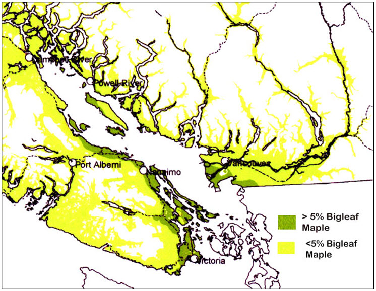
Long description for Appendix 2 - Figure
A map of Southern Vancouver Island including the southwestern mainland of British Columbia showing regions that are either greater or less than 5% Bigleaf Maple. Most of the greater than 5% Bigleaf maple regions occur along the east and southeast of Vancouver Island, especially on the many small Islands between Nanaimo and Victoria, and on the mainland south of Vancouver along the coast. The less than 5% Bigleaf Maple occurs inland and where more the 5% Bigleaf Maple does not occur, most notably through river valleys and inlets at lower elevations.