
Behr’s hairstreak (Satyrium behrii) recovery strategy 2016: part 2
Appendix 1. Maps of Critical Habitat for Behr's Hairstreak in Canada
Critical habitat for Behr's Hairstreak has been identified at seven known extant sites in the South Okanagan Valley of British Columbia, Canada (Figures A1-A8). Critical habitat is only partially identified at four of these sites (i.e., Kaleden, Vaseux Lake and McIntyre Bluff, East of Oliver, and South of Oliver):
- Kaleden (Figure A1): corresponds with BC CDC EO #11
- Okanagan Falls (Figure A2), Vaseux Lake and McIntyre Bluff (Figure A3): corresponds with BC CDC EO #5
- West of Oliver (Fairview) (Figure A4): corresponds with BC CDC EO #7
- East of Oliver (Figure A5): corresponds with BC CDC EO #15
- South of Oliver (Figure A6): corresponds with BC CDC EO #13
- Osoyoos (Figure A7): corresponds with BC CDC EO #10
- East of Osoyoos (Figure A8): corresponds with BC CDC EO #8
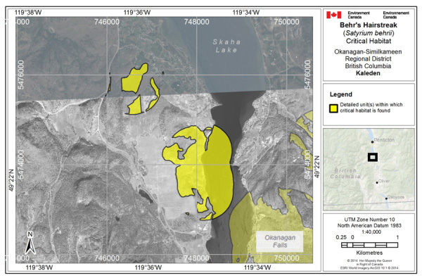
Long description for Figure A.1.
Figure A1 shows a map of the Critical habitat for Behr’s Hairstreak at Kaleden, British Columbia (corresponds with BC CDC EO #11) is represented by polygons, where the criteria and methodology set out in Section 6.1 are met (i.e., 238.3 ha in total).
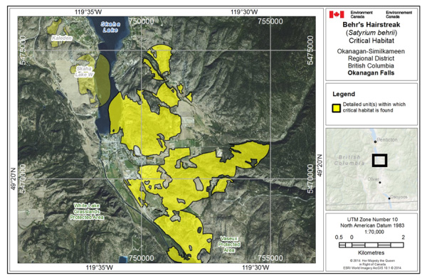
Long description for Figure A.2.
Figure A2 shows a map of the Critical habitat for Behr’s Hairstreak at Okanagan Falls, British Columbia (corresponds with BC CDC EO #5) is represented by polygons, where the criteria and methodology set out in Section 6.1 are met (i.e., 1512.2 ha in total).
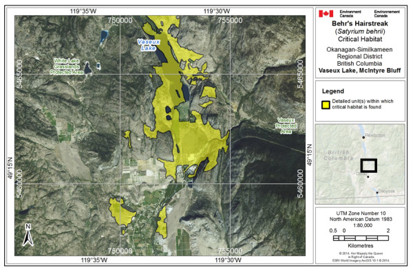
Long description for Figure A.3.
Figure A3 shows a map of the Critical habitat for Behr’s Hairstreak at Vaseux Lake and McIntyre Bluff, British Columbia (corresponds with BC CDC EO #5) is represented by polygons, where the criteria and methodology set out in Section 6.1 are met (i.e., 1273.2 ha in total).
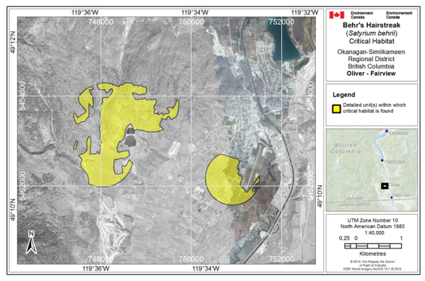
Long description for Figure A.4.
Figure A4 shows the Critical habitat for Behr’s Hairstreak at west Oliver - Fairview, British Columbia (corresponds with BC CDC EO #7) is represented by polygons, where the criteria and methodology set out in Section 6.1 are met (i.e., 306.3 ha in total).
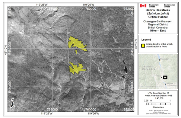
Long description for Figure A.5.
Figure A5 shows the Critical habitat for Behr’s Hairstreak at east Oliver, British Columbia (corresponds with BC CDC EO #15) is represented by the polygons, where the criteria and methodology set out in Section 6.1 are met (i.e., 73.7 ha in total).
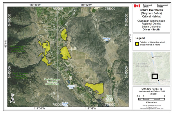
Long description for Figure A.6.
Figure A6 shows the Critical habitat for Behr’s Hairstreak south of Oliver, British Columbia (corresponds with BC CDC EO #13) is represented by the polygons, where the criteria and methodology set out in Section 6.1 are met (i.e., 374.0 ha in total).
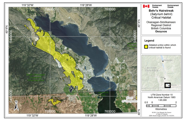
Long description for Figure A.7.
Figure A7 shows the Critical habitat for Behr’s Hairstreak at Osoyoos, British Columbia (corresponds with BC CDC EO #10) is represented by the polygons, where the criteria and methodology set out in Section 6.1 are met (i.e., 682.5 ha in total).
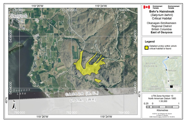
Long description for Figure A.8.
Figure A8 shows the Critical habitat for Behr’s Hairstreak at east Osoyoos, British Columbia (corresponds with BC CDC EO #8) is represented by polygons, where the criteria and methodology set out in Section 6.1 are met (i.e., 51.6 ha in total).