
Mormon metalmark (Apodemia mormo) proposed recovery strategy 2017
Official title: Recovery Strategy for the Mormon Metalmark (Apodemia mormo), Southern Mountain Population, in Canada [Proposed] - 2017
Table of contents
Species at Risk Act
Recovery Strategy Series
Adopted under Section 44 of SARA
Mormon Metalmark
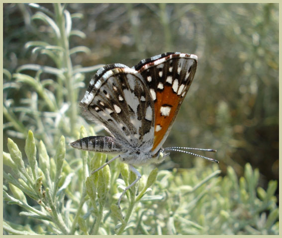
Credit: Jennifer Heron © B.C. Ministry of Environment
Part 1 - Table of contents
- Part 1 – Federal addition to the Recovery Strategy for the Mormon Metalmark (Apodemia mormo) Southern Mountain Population in British Columbia, prepared by Environment and Climate Change Canada
- Table of contents
- Preface
- Acknowledgements
- Additions and modifications to the adopted document
- Executive summary
- Recovery feasibility summary
- 1 COSEWIC species assessment information
- 2 Species status information
- 3 Species information
- 4 Threats
- 5 Population and distribution objective
- 6 Broad strategies and general approaches to meet objectives
- 7 Critical habitat
- 8 Measuring progress
- 9 Statement on action plans
- 10 Effects on the environment and other species
- 11 References
List of figures
- Figure 1. Critical habitat for Mormon Metalmark at Keremeos (location #2), Bullock Creek, N (location #9), and Keremeos, SW – Riverside Estates (location #16), B.C. is represented by the yellow shaded polygons (unit(s)), in accordance with the criteria set out in Section 7.1. The detailed polygons show a total of 328.6 ha containing critical habitat at these locations (16.7 ha at #2 and 311.8 ha at #9 & #16).
- Figure 2. Critical habitat for Mormon Metalmark at Richter Mountain, SW (location #3) and Frank Lake, N (location #14), B.C. is represented by the yellow shaded polygons (unit(s)), in accordance with the criteria set out in Section 7.1. The detailed polygons show a total of 300.2 ha containing critical habitat at these locations (224.37 ha at #3 and 75.9 ha at #14).
- Figure 3. Critical habitat for Mormon Metalmark at Similkameen River – Goat view, B.C. (location #5) is represented by the yellow shaded polygon (unit), in accordance with the criteria set out in Section 7.1. The detailed polygon shows a total of 130.3 ha containing critical habitat at this location.
- Figure 4. Critical habitat for Mormon Metalmark at Keremeos-Suncatchers, B.C. (location #6) is represented by the yellow shaded polygon (unit), in accordance with the criteria set out in Section 7.1. The detailed polygon shows a total of 74.6 ha containing critical habitat at this location.
- Figure 5. Critical habitat for Mormon Metalmark at Olalla, B.C. (location #7) is represented by the yellow shaded polygons (unit(s)), in accordance with the criteria set out in Section 7.1. The detailed polygons show a total of 94.9 ha containing critical habitat at this location.
- Figure 6. Critical habitat for Mormon Metalmark at Keremeos – Gravel Pit (location #10) and Cawston, W of (location #13), B.C. are represented by the yellow shaded polygons (unit(s)), in accordance with the criteria set out in Section 7.1. The detailed polygons show a total of 246.2 ha containing critical habitat at these locations (75.9 ha at #10 and 170.3 ha at #13).
- Figure 7. Critical habitat for Mormon Metalmark Southern Mountain population at Paul Creek, North, B.C. (location #12) is represented by the yellow shaded polygon (unit), in accordance with the criteria set out in Section 7.1. The detailed polygon shows a total of 61.1 ha containing critical habitat at this location.
- Figure 8. Critical habitat for Mormon Metalmark Southern Mountain population at Spotted Lake, B.C. (location #15) is represented by the yellow shaded polygon (unit), in accordance with the criteria set out in Section 7.1. The detailed polygon shows a total of 113.7 ha containing critical habitat at this location.
List of tables
- Table 1. Conservation status of Mormon Metalmark Southern Mountain population (from NatureServe 2015 and B.C. conservation framework 2015).
- Table 2. Summary of Mormon Metalmark Southern Mountain population locations in Canada, as of 2015. Location numbers align with those provided by COSEWIC (2014), with the addition of location 17 (not numbered by COSEWIC); with last observation (Last Obs.) and status shown for each site.
- Table 3. IUCN-CMP threats classification for Mormon Metalmark Southern Mountain population.
- Table 4. Summary of ongoing recovery-related Mormon Metalmark work completed as of 2015.
- Table 5. Recovery planning table for Mormon Metalmark Southern Mountain population in Canada. Threats are according to the IUCN-CMP classification (refer to Table 3). Priority is characterized as essential (urgent and important, needs to start immediately), necessary (important but not urgent, action can start in 2-5 years), or beneficial (action would be beneficial at any time that it was feasible to start).
- Table 6. Schedule of studies to identify critical habitat.
- Table 7. Activities likely to result in the destruction of critical habitat for Mormon Metalmark Southern Mountain population. IUCN threat numbers are in accordance with the IUCN-CMP (World Conservation Union–Conservation Measures Partnership) unified threats classification system (CMP 2010).
Part 2 - Table of contents
- Part 2 – Recovery Strategy for the Mormon Metalmark (Apodemia mormo) Southern Mountain population in British Columbia, prepared by the British Columbia Ministry of Environment
- Table of contents
- Background
- Recovery
- Recovery feasibility
- Recovery goal
- Rationale for the recovery goal and objectives
- Recovery objectives (2008 to 2012)
- Approaches recommended to meet recovery objectives
- Performance measures
- Critical habitat
- Existing and recommended approaches to habitat protection
- Effects on other species
- Socioeconomic considerations
- Recommended approach for recovery implementation
- Statement on action plans
- References
List of tables
List of figures
Page details
- Date modified: