
Pugnose shiner (Notropis anogenus): recovery strategy 2012
Table of contents
- Preface
- Responsible jurisdictions
- Authors
- Acknowledgements
- Strategic environmental assessment statement
- Executive summary
- 1. Background
- 2. Recovery
- 2.1 Recovery feasibility
- 2.2 Recovery goals
- 2.3 Population and distribution objective(s)
- 2.4 Recovery objectives
- 2.5 Approaches recommended to meet recovery objectives
- 2.6 Performance measures
- 2.7 Critical habitat
- 2.7.1 Identification of the Pugnose Shiner critical habitat
- 2.7.2 Information and methods used to identify critical habitat
- 2.7.3 Identification of critical habitat: biophysical function, features and their attributes
- 2.7.4 Identification of critical habitat: geospatial
- 2.7.5. Schedule of studies to identify critical habitat
- 2.7.6. Examples of activities likely to result in the destruction of critical habitat
- 2.8 Existing and recommended approaches to habitat protection
- 2.9 Effects on other species
- 2.10 Recommended approach for recovery implementation
- 2.11 Statement on action plans
- 3. References
- 4. Recovery team members
- Appendix 1
List of figures
- Figure 1. Pugnose Shiner (Notropis anogenus)
- Figure 2. North American distribution of the Pugnose Shiner
- Figure 3a. Distribution of Pugnose Shiner in southwestern Ontario
- Figure 3b. Distribution of Pugnose Shiner in southeastern Ontario
- Figure 4. Area within which critical habitat is found in the Teeswater River
- Figure 5. Area within which critical habitat is found in the Old Ausable Channel
- Figure 6. Area within which critical habitat is found in Mouth Lake
- Figure 7. Area within which critical habitat is found in the St. Clair National Wildlife Area
- Figure 8. Area within which critical habitat is found in Little Bear Creek
- Figure 9a. Area within which critical habitat is found in Long Point Bay
- Figure 9b. Area within which critical habitat is found in Big Creek
- Figure 10. Area within which critical habitat is found in Wellers Bay
- Figure 11. Area within which critical habitat is found in West Lake and East Lake
- Figure 12. Area within which critical habitat is found in Waupoos Bay
- Figure 13a. Area within which critical habitat is found in the St. Lawrence River
- Figure 13b. Area within which critical habitat is found in the St. Lawrence River
List of tables
- Table 1. Canadian and U.S. national and sub-national status ranks for Pugnose Shiner from NatureServe 2012
- Table 2. Population status and associated certainty of individual Pugnose Shiner populations in Canada
- Table 3. Summary of threats to Pugnose Shiner populations in Canada
- Table 4. Summary of recent (since 2000) fish assemblage surveys in areas of known Pugnose Shiner occurrence
- Table 5. Recovery planning table – research and monitoring
- Table 6. Recovery planning table – management and coordination
- Table 7. Recovery planning table – stewardship, outreach and awareness
- Table 8. Performance measures for evaluating the achievement of recovery objectives
- Table 9. Essential functions, features and attributes of critical habitat for each life stage of the Pugnose Shiner
- Table 10. Coordinates locating the boundaries within which critical habitat is found for the Pugnose Shiner at twelve locations
- Table 11. Comparison of area within which critical habitat is found for each Pugnose Shiner population, relative to the estimated minimum area for population viability (MAPV)
- Table 12. Schedule of studies to identify critical habitat
- Table 13. Human activities likely to result in the destruction of critical habitat for Pugnose Shiner

About the Species at Risk Act Recovery Strategy Series
What is the Species at Risk Act (SARA)?
SARA is the Act developed by the federal government as a key contribution to the common national effort to protect and conserve species at risk in Canada. SARA came into force in 2003 and one of its purposes is “to provide for the recovery of wildlife species that are extirpated, endangered or threatened as a result of human activity.”
What is recovery?
In the context of species at risk conservation, recovery is the process by which the decline of an endangered, threatened, or extirpated species is arrested or reversed and threats are removed or reduced to improve the likelihood of the species’ persistence in the wild. A species will be considered recovered when its long-term persistence in the wild has been secured.
What is a recovery strategy?
A recovery strategy is a planning document that identifies what needs to be done to arrest or reverse the decline of a species. It sets goals and objectives and identifies the main areas of activities to be undertaken. Detailed planning is done at the action plan stage.
Recovery strategy development is a commitment of all provinces and territories and of three federal agencies -- Environment Canada, Parks Canada Agency, and Fisheries and Oceans Canada -- under the Accord for the Protection of Species at Risk. Sections 37–46 of SARAoutline both the required content and the process for developing recovery strategies published in this series.
Depending on the status of the species and when it was assessed, a recovery strategy has to be developed within one to two years after the species is added to the List of Wildlife Species at Risk. Three to four years is allowed for those species that were automatically listed when SARA came into force.
What’s next?
In most cases, one or more action plans will be developed to define and guide implementation of the recovery strategy. Nevertheless, directions set in the recovery strategy are sufficient to begin involving communities, land users, and conservationists in recovery implementation. Cost-effective measures to prevent the reduction or loss of the species should not be postponed for lack of full scientific certainty.
The series
This series presents the recovery strategies prepared or adopted by the federal government under SARA. New documents will be added regularly as species get listed and as strategies are updated.
To learn more about the Species at Risk Act and recovery initiatives, please consult the SARA Public Registry.
Recommended citation
Fisheries and Oceans Canada. 2012. Recovery strategy for the Pugnose Shiner (Notropis anogenus) in Canada (Proposed). Species at Risk Act Recovery Strategy Series. Fisheries and Oceans Canada, Ottawa ON. xi +75 p.
Additional copies
Additional copies can be downloaded from the SARA Public Registry.
Cover, title page illustration
© Konrad Schmidt
Également disponible en français sous le titre
« Programme de rétablissement du méné camus(Notropis anogenus) au Canada »
Her Majesty the Queen in Right of Canada, represented by the Minister of Fisheries and Oceans, 2012. All rights reserved.
ISBN En3-4/129-2012E-PDF
Catalogue Number (no.) 978-1-100-19999-3
Content (excluding the illustrations) may be used without permission, with appropriate credit to the source.
Preface
The Pugnose Shiner is a freshwater fish and is under the responsibility of the federal government. The Species at Risk Act (SARA, Section 37) requires the competent minister to prepare recovery strategies for listed Extirpated, Endangered and Threatened species. The Pugnose Shiner was listed as Endangered under SARA in June 2003. The development of this recovery strategy was led by Fisheries and Oceans Canada – Central and Arctic region, in cooperation and consultation with many individuals, organizations and government agencies, as indicated below. The strategy meets SARA requirements in terms of content and process (Sections 39-41).
Success in the recovery of this species depends on the commitment and cooperation of many different constituencies that will be involved in implementing the directions set out in this strategy and will not be achieved by Fisheries and Oceans Canada, Environment Canada (Canadian Wildlife Service – Ontario) and Parks Canada Agency or any other party alone. This strategy provides advice to jurisdictions and organizations that may be involved or wish to become involved in the recovery of the species. In the spirit of the National Accord for the Protection of Species at Risk, the Minister of Fisheries and Oceans and the Minister of the Environment invite all responsible jurisdictions and Canadians to join Fisheries and Oceans Canada, Environment Canada (Canadian Wildlife Service – Ontario), and Parks Canada Agency in supporting and implementing this strategy for the benefit of the Pugnose Shiner and Canadian society as a whole. Fisheries and Oceans Canada, Environment Canada (Canadian Wildlife Service – Ontario) and Parks Canada Agency will support implementation of this strategy to the extent possible, given available resources and their overall responsibility for species at risk conservation.
The goals, objectives and recovery approaches identified in the strategy are based on the best existing knowledge and are subject to modifications resulting from new information. The competent ministers will report on progress within five years.
This strategy will be complemented by one or more action plans that will provide details on specific recovery measures to be taken to support conservation of the species. The Minister of Fisheries and Oceans will take steps to ensure that, to the extent possible, Canadians interested in or affected by these measures will be consulted.
Responsible jurisdictions
Fisheries and Oceans Canada
Environment Canada, Canadian Wildlife Service - Ontario
Parks Canada Agency
Authors
This document was prepared by Andrea Doherty (Fisheries and Oceans Canada), Amy L. Boyko (Fisheries and Oceans Canada), Sarah P. Matchett (contractor) and Shawn K. Staton (Fisheries and Oceans Canada) on behalf of Fisheries and Oceans Canada.
Acknowledgements
Fisheries and Oceans Canada would like to thank the following organizations for their support in the development of the Pugnose Shiner recovery strategy: Ontario Freshwater Fish Recovery Team, Ontario Ministry of Natural Resources, Ontario Parks, Ausable Bayfield Conservation Authority, Essex Region Conservation Authority, Trent University, Environment Canada (Canadian Wildlife Service), University of Western Ontario, Parks Canada Agency, St. Clair Region Conservation Authority, Cataraqui Region Conservation Authority, Quinte Region Conservation Authority and the Saugeen Valley Conservation Authority.
Strategic environmental assessment
In accordance with the Cabinet Directive on the Environmental Assessment of Policy, Plan and Program Proposals, the purpose of a Strategic Environmental Assessment (SEA) is to incorporate environmental considerations into the development of public policies, plans, and program proposals to support environmentally-sound decision making.
Recovery planning is intended to benefit species at risk and biodiversity in general. However, it is recognized that strategies may also inadvertently lead to environmental effects beyond the intended benefits. The planning process based on national guidelines directly incorporates consideration of all environmental effects, with a particular focus on possible impacts on non-target species or habitats.
This recovery strategy will clearly benefit the environment by promoting the recovery of the Pugnose Shiner. The potential for the strategy to inadvertently lead to adverse effects on other species was considered. The SEA concluded that this strategy will clearly benefit the environment and will not entail any significant adverse effects. Refer to the following sections of the document in particular: Description of the Species’ Habitat and Biological Needs, Ecological Role, and Limiting Factors; Effects on Other Species; and, the Recommended Approaches to Meet Recovery Objectives.
Residence
SARA defines residence as: “a dwelling-place, such as a den, nest or other similar area or place, that is occupied or habitually occupied by one or more individuals during all or part of their life cycles, including breeding, rearing, staging, wintering, feeding or hibernating” (SARA S2(1)).
The residence concept is interpreted by Fisheries and Oceans Canada as being constructed by the organism. In this context, Pugnose Shiner do not construct residences during their life cycle and therefore the concept does not apply (Bouvier et al. 2010).
Executive summary
The Pugnose Shiner is a small minnow that is distinguished from similar species by its tiny, upturned, mouth and black stomach cavity lining. Colouration is mostly silver with yellow and olive tints above the lateral black band where scales are heavily outlined. Male Pugnose Shiner can reach total lengths (TL) of 50 mm, while females can reach up to 60 mm TL. This species is found in highly vegetated, clear, slow-moving water, and its distribution and recovery potential is believed to be limited by the distribution and abundance of these habitat types. The Pugnose Shiner is considered globally rare to uncommon (G3), and was designated as Endangered in Canada in November 2002 by the Committee on the Status of Endangered Wildlife in Canada. Status at state levels varies from extirpated (SX – Ohio) to vulnerable (S3 in Michigan and Minnesota).
In Canada, Pugnose Shiner distribution is limited to four main regions of Ontario: the southern drainage of Lake Huron, Lake St. Clair, Lake Erie, Lake Ontario and the St. Lawrence River. The species was known historically from Lake Erie (Point Pelee National Park, Rondeau Bay and Long Point Bay) and the St. Lawrence River (Gananoque). Recent captures have confirmed that the species is extant in the following areas:
- Teeswater River,
- Old Ausable Channel,
- Mouth Lake,
- Canard River,
- Lake St. Clair (including Walpole Island) and two of its tributaries (Whitebread Drain/Grape Run Drain and Little Bear Creek),
- St. Clair National Wildlife Area,
- Long Point Bay/Big Creek (including Long Point National Wildlife Area [both Thoroughfare Point Unit and Long Point Unit] and Big Creek National Wildlife Area [Big Creek Unit only]),
- Wellers Bay (including all occasionally exposed lands of Wellers Bay National Wildlife Area lying between the high-water mark and the water’s edge of Wellers Bay, which forms the boundary of Wellers Bay National Wildlife Area and which varies with water level fluctuations of Lake Ontario),
- West Lake,
- East Lake,
- Waupoos Bay, and,
- St. Lawrence River (from Eastview to Mallorytown Landing, including the St. Lawrence Islands National Park).
Extant populations in Ontario occur in areas that are vulnerable to declining habitat quality. Habitat loss and degradation is the principal threat to Pugnose Shiner and may be the result of various factors, such as poor agricultural practices leading to siltation and turbidity, increases in lakeshore development and the removal of aquatic vegetation, as well as human-induced changes in water quality/quantity. The fragmented nature of preferred habitat prevents connectivity of existing populations and may prevent gene flow and/or inhibit colonization of other suitable habitats. Changes in fish communities where Pugnose Shiner are found may have negative effects on the species due to increased predation and/or interspecific competition for resources. Increases in some exotic species, such as Common Carp and Eurasian watermilfoil, may also affect Pugnose Shiner, due to the negative impacts these species can have on native aquatic vegetation.
The long-term recovery goal (over the next 20 years) for Pugnose Shiner is to maintain self-sustaining populations at existing locations and restore self-sustaining populations to historic locations, where feasible.
The following short-term objectives have been established to assist with meeting the long-term recovery goal over the next five to ten years:
- Refine population and distribution objectives;
- Refine and protect critical habitat;
- Determine long-term population and habitat trends;
- Evaluate and minimize threats to the species and its habitat;
- Investigate the feasibility of population supplementation or repatriation for populations that may be extirpated or reduced;
- Enhance efficiency of recovery efforts through coordination with aquatic and terrestrial ecosystem recovery teams and other relevant or complementary groups/initiatives; and,
- Improve overall awareness of Pugnose Shiner and the role of healthy aquatic ecosystems, and their importance to humans.
The recovery team has identified several approaches necessary to ensure that recovery objectives for Pugnose Shiner are met. These approaches have been organized into three categories: Research and Monitoring; Management and Coordination; and, Stewardship, Outreach, and Awareness. Research and Monitoring strategies are crucial to the recovery of Pugnose Shiner because many aspects of its life history and biology are not well known, including its capacity to rebound demographically. Initial surveys will verify extant and uncorroborated accounts of Pugnose Shiner across its range, while a detailed, permanent monitoring program will observe the health of the species and its habitat, as well as potential predators, competitors and exotic species. Research projects will help resolve some uncertainty related to specific habitat requirements, feasibility of population repatriations, and threat mitigation. Management and Coordination strategies include working with other relevant groups, recovery teams and aquatic ecosystem-level recovery strategies that are currently being implemented within a number of the watersheds where Pugnose Shiner is known to occur, namely the Old Ausable Channel, Lake St. Clair (Walpole Island) and the Essex-Erie region. This will allow relevant groups and teams to share information and implement recovery actions. Lastly, through the broad approaches of Stewardship, Outreach and Awareness, the importance of the recovery of Pugnose Shiner will be conveyed to the community at large and stakeholder groups in particular, to obtain support for recovery implementation.
Critical habitat has been identified to the extent possible based upon the best available information for extant Pugnose Shiner locations in the following areas:
- Teeswater River,
- Old Ausable Channel,
- Mouth Lake,
- St. Clair National Wildlife Area,
- Little Bear Creek (Lake St. Clair tributary),
- Long Point Bay/Big Creek (including Long Point National Wildlife Area [both Thoroughfare Point Unit and Long Point Unit] and Big Creek National Wildlife Area [Big Creek Unit only]),
- Wellers Bay (including all occasionally exposed lands of Wellers Bay National Wildlife Area lying between the high-water mark and the water’s edge of Wellers Bay, which forms the boundary of Wellers Bay National Wildlife Area which varies with water level fluctuations of Lake Ontario),
- West Lake,
- East Lake,
- Waupoos Bay, and,
- St. Lawrence River (from Eastview to Mallorytown Landing, including the St. Lawrence Islands National Park).
A schedule of studies has been developed that outlines necessary steps to obtain the information to further refine these critical habitat descriptions.
A dual approach to recovery implementation will be taken combining an ecosystem-based approach with a single-species focus. This will be accomplished through coordinated efforts with relevant ecosystem-based recovery teams (Ausable River, Essex-Erie region, Walpole Island) and their associated Recovery Implementation Groups. The recovery strategy will be supported by one or more action plans that will be developed within five years of the final strategy being posted on the public registry. The success of recovery actions in meeting recovery objectives will be evaluated through the performance measures provided. The entire recovery strategy will be reported on every five years to evaluate progress and to incorporate new information.
1. Background
1.1 Species Assessment Information from COSEWIC
Common name (population): Pugnose Shiner
Scientific name: Notropis anogenus
Current COSEWICstatus & year of designation:Endangered 2002
Canadian occurrence: Ontario
Reason for designation: The Pugnose Shiner has a limited, fragmented Canadian distribution, being found only in Ontario where it is subject to declining habitat quality. The isolated nature of its preferred habitat may prevent connectivity of fragmented populations and may prevent gene flow between existing populations and inhibit re-colonization of other suitable habitats.
COSEWICstatus history: Designated Special Concern in April 1985. Status re-examined and designated Endangered in November 2002.
1.2 Description
The Pugnose Shiner (Notropis anogenus Forbes, 1885) (Figure 1) is a slender, moderately compressed, silvery minnow with a lateral black stripe, and a blunt snout ending in an extremely small, upturned, mouth (Becker 1983; Holm and Mandrak 2002). Total length (TL) is approximately 50 mm for males and 60 mm for females (Holm and Mandrak 2002), but individuals have been caught as large as 72 mm. Overall colouration is silvery with pale yellow tints on the back and silvery below This species is sexually dimorphic during the breeding season when the males take on a bright golden colouration (Smith 1985). The dark lateral band extends from the snout through the eye to the end of the caudal peduncle, terminating in a small dark wedge-shaped caudal spot. All fins are transparent and, unlike other Notropis spp., the peritoneum (lining of abdominal cavity) is black (Holm and Mandrak 2002). The mouth is positioned almost vertical to the body axis (Becker 1983) and is the distinguishing feature that separates the Pugnose Shiner from other species in the black-lined shiner group, especially when they are age-0 juveniles (Leslie and Timmins 2002). This species is most similar in appearance to the Blackchin Shiner (N. heterodon), which is distinguished from the Pugnose Shiner by its larger mouth (Holm and Mandrak 2002). The Pugnose Shiner is also similar in appearance to the Pugnose Minnow (Opsopoeodus emiliae) and Bridle Shiner (N. bifrenatus). The Pugnose Minnow can be distinguished from the Pugnose Shiner by dark areas on the dorsal fin, crosshatched areas on the upper surface and nine dorsal rays (Pugnose Shiner typically has eight dorsal rays) (Page and Burr 1991; Scott and Crossman 1998). The Bridle Shiner is distinguished from the Pugnose Shiner by its larger, upturned mouth, seven anal rays and incomplete lateral line (Page and Burr 1991; Scott and Crossman 1998).
Figure 1. Pugnose Shiner (Notropis anogenus)
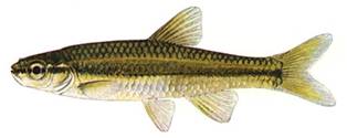
(Illustration by Ellen Edmonson, New York State Department of Environmental Conservation)
Long description of Figure 1
Figure 1 is a coloured illustration by Ellen Edmonson, New York State Department of Environmental Conservation, from the side, of a Pugnose Shiner.
1.3 Populations and distribution
Global range
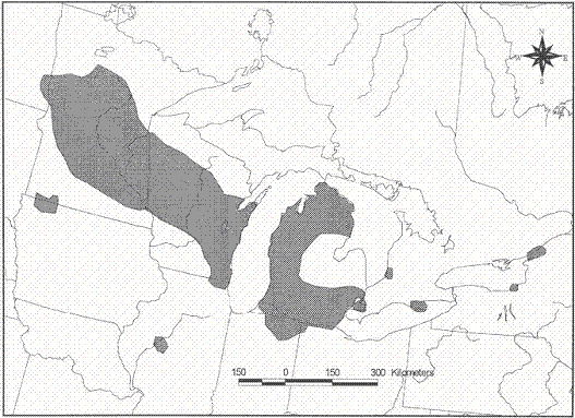
The Pugnose Shiner has a limited and disjunct distribution in North America (Figure 2). It is found in the upper Mississippi River, Red River of the North and the Great Lakes basins (Holm and Mandrak 2002). It is found in several tributaries of the Mississippi River in Illinois, Minnesota and Wisconsin, and in the upper Red River of the North drainage of Minnesota and North Dakota (Holm and Mandrak 2002). Within the Great Lakes basin, the Pugnose Shiner is known from tributaries of lakes Huron, Michigan, St. Clair, Erie, eastern Lake Ontario and the upper St. Lawrence River (Holm and Mandrak 2002). Recent declines have been observed across its distribution, although this species has not been monitored sufficiently to determine population trends throughout its range (NatureServe 2012).
Figure 2. North American distribution of the Pugnose Shiner modified from Page and Burr (1991).
Long description of Figure 2
Figure 2 is a line drawing of a map of the Great Lakes area and surrounding regions of the United States and Canada. A scale is provided. The map shows two major areas identified with Pugnose Shiner populations as well as several disjunct smaller areas. These areas are shaded in grey and include tributaries of the Mississippi River in Illinois, Minnesota and Wisconsin, and the upper Red River of the North drainage of Minnesota and North Dakota and, within the Great Lakes basin, tributaries of lakes Huron, Michigan, St. Clair, Erie, eastern Lake Ontario and the upper St. Lawrence River. The map has been modified from A Field Guide to Freshwater Fishes of North America North of Mexico (Page and Burr 1991).
Canadian range
In Canada, this species has only been recorded south of 46 degrees latitude (Leslie and Timmins 2002) in four main areas of Ontario (Figure 3a, 3b): southern Lake Huron, Lake St. Clair, Lake Erie, and eastern Lake Ontario/upper St. Lawrence River.
The species is considered to be extant in the following areas:
- Teeswater River (Saugeen watershed) (Fisheries and Oceans Canada [DFO], unpublished data),
- Old Ausable Channel (Ausable River Recovery Team [ARRT] 2006),
- Mouth Lake (DFO, unpublished data),
- Canard River (Royal Ontario Museum [ROM], unpublished data),
- Lake St. Clair (including Walpole Island) (Holm and Mandrak 2002) and two of its tributaries (Whitebread Drain/Grape Run Drain and Little Bear Creek) (Mandrak et al. 2006b; ROM unpublished data),
- St. Clair National Wildlife Area (Bouvier et al. 2010),
- Long Point Bay/Big Creek (including Long Point National Wildlife Area [both Thoroughfare Point Unit and Long Point Unit] and Big Creek National Wildlife Area [Big Creek Unit only] (Marson et al. 2010) - from this point forward, the phrase Long Point Bay/Big Creek includes reference to the National Wildlife Areas) (Marson et al. 2009),
- Wellers Bay (including all occasionally exposed lands of Wellers Bay National Wildlife Area lying between the high water mark and the water’s edge of Wellers Bay, which forms the boundary of Wellers Bay National Wildlife Area which varies with water level fluctuations of Lake Ontario [DFO, unpublished data] – from this point forward, the phrase Wellers Bay includes reference to the National Wildlife Areas),
- West Lake (DFO, unpublished data),
- East Lake (DFO, unpublished data),
- Waupoos Bay (DFO, unpublished data), and,
- St. Lawrence River (from Eastview to Mallorytown Landing, including the St. Lawrence Islands National Park) (Carlson 1997; Mandrak etal.2006a; J. Van Wieren, Parks Canada [PCA] unpublished data).
Pugnose Shiner was last captured from the Gananoque River in 1935, Point Pelee National Park in 1941, and Rondeau Bay in 1963 (Holm and Mandrak 2002).
Scott and Crossman (1998) described the Canadian range of Pugnose Shiner as diminishing and surmised that it probably occurred historically between the two widely separated areas where it is now found, along the northern shores of lakes Erie and Ontario.
Percentage of global distribution in Canad
Less than 10% of the species’ global range occurs in Canada (ARRT2006).
Distribution trend
The change in the distribution of Pugnose Shiner is difficult to assess due to a lack of data, which has been attributed to the species’ small size, difficulties with field identification and a lack of time-series data (Holm and Mandrak 2002). Three Canadian occurrences are believed to have been lost over the last 50 years (Gananoque River, Point Pelee National Park and Rondeau Bay); however, Pugnose Shiner has been found at a number of new locations across its range, including Mouth Lake, Teeswater River, Little Bear Creek and Whitebread Drain, Wellers Bay, West Lake, East Lake, and Waupoos Bay, as well as numerous locations within the stretch of the St. Lawrence River (approximately 45 km long) between Eastview and Mallorytown Landing, including the St. Lawrence Islands National Park.
Global population size and status
Global population estimates for Pugnose Shiner are not available; however, it is considered generally rare but sometimes locally abundant (NatureServe 2012). It is listed as globally vulnerable, extirpated in Ohio, critically imperilled in Illinois, Indiana, Iowa, New York, and North Dakota, and, vulnerable in Michigan and Minnesota (NatureServe 2012). National and sub-national status ranks are summarized in Table 1.
| Rank level | Rank1 | Jurisdictions |
|---|---|---|
| National (N) | N2 | Canada |
| National (N) | N3 | United States |
| Sub-national (S): Canada | S2 | Ontario |
| Sub-national (S): United States | S1 | Illinois, Indiana, Iowa, New York, North Dakota |
| Sub-national (S): United States | S2 | Wisconsin |
| Sub-national (S): United States | S3 | Michigan, Minnesota |
| Sub-national (S): United States | SX | Ohio |
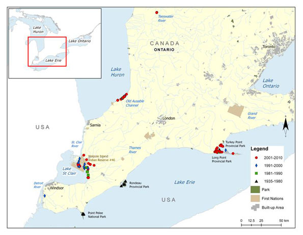
Figure 3a. Distribution of Pugnose Shiner in southwestern Ontario
Long description of Figure 3a
Figure 3a is a map of southwestern Ontario with an inset at the top left of the map showing the geographical location of this map on a larger scale map. A legend and scale are provided. The legend provides symbols denoting years of capture (2001–2010, 1991–2000, 1981–1990, and 1935–1980) as well as for Parks, First Nations, and Built-up Areas. Individual data points are identified by year of capture. The map shows that, for the time period 2001–2010, Pugnose Shiner was found at, or near, the Old Ausable Channel along the Lake Huron shoreline, the Teeswater River, in areas in, or near, the Walpole Island Indian Reserve along the Lake St. Clair shoreline and the mouth of the St. Clair River, and at, or near, Long Point Provincial Park and Turkey Point Provincial Park. Distribution for the time period 1991–2000 was in, or near, the Walpole Island Indian Reserve along the Lake St. Clair shoreline and the mouth of the St. Clair River, with several data points in Long Point Provincial Park and along the Lake Huron shoreline near the Old Ausable Channel. Data points for the 1981–1990 time period are scattered along the shoreline of Lake St. Clair, south of Walpole Island Indian Reserve. Older data points from 1935–1980 are shown at Point Pelee National Park, and Rondeau Provincial Park.
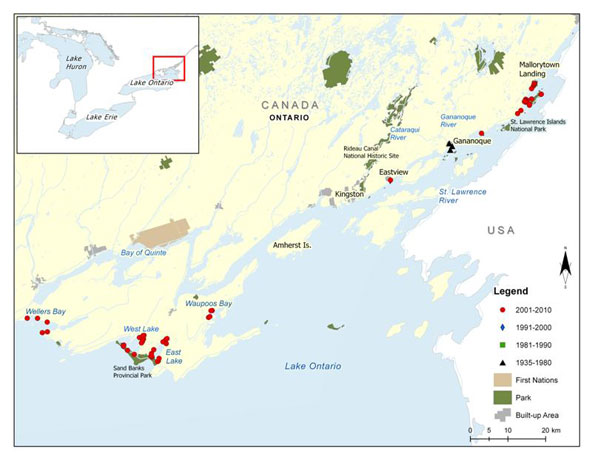
Figure 3b. Distribution of Pugnose Shiner in southeastern Ontario
Long description of Figure 3b
Figure 3b is a map of the eastern end of Lake Ontario with an inset at the top left of the map showing the geographical location of this map on a larger scale map. A legend and scale are provided. The legend provides symbols denoting years of capture (2001–2010, 1991–2000, 1981–1990, and 1935–1980) as well as for Parks, First Nations, and Built-up Areas. Individual data points are identified by year of capture. The map shows that, for the time period 2001–2010, Pugnose Shiner was found in the in the upper St. Lawrence River, upstream of Mallorytown Landing and at, or near Gananoque, Eastview, Waupoos Bay, West Lake, East Lake, and Sand Banks Provincial Park. Older data points from 1935–1980 are shown at the mouth of the Gananoque River.
Canadian population size and status
The status of Pugnose Shiner populations in Canada was assessed by Bouvier et al. (2010) (Table 2). Populations were ranked with respect to abundance and trajectory. Population abundance and trajectory were then combined to determine the population status. A certainty level was also assigned to the population status, which reflected the lowest level of certainty associated with either population abundance or trajectory. Refer to Bouvier et al. (2010) for further details on the methodology.
| Drainage Area | Population2 | Population status | Certainty3 |
|---|---|---|---|
| Lake Huron drainage | TeeswaterRiver | Unknown | 3 |
| Lake Huron drainage | Old Ausable Channel | Fair | 2 |
| Lake Huron drainage | MouthLake4 | Unknown | 3 |
| Lake St. Clair drainage | St. Clair National Wildlife Area | Unknown | 3 |
| Lake St. Clair drainage | Lake St. Clair and Tributaries | Fair | 2 |
| Lake Erie drainage | Long Point Bay/Big Creek | Poor | 2 |
| Lake Erie drainage | Canard River | Unknown | 3 |
| Lake Erie drainage | Point Pelee National Park | Extirpated | 3 |
| Lake Erie drainage | Rondeau Bay | Extirpated | 3 |
| Lake Ontario drainage | GananoqueRiver | Extirpated | 3 |
| Lake Ontario drainage | Wellers Bay4 | Unknown | 3 |
| Lake Ontario drainage | West Lake | Unknown | 2 |
| Lake Ontario drainage | East Lake4 | Unknown | 3 |
| Lake Ontario drainage | Waupoos Bay4 | Unknown | 3 |
| Lake Ontario drainage | St. Lawrence River | Good | 2 |
(modified from Bouvier et al. 2010)
Lake Huron drainage
The first record of Pugnose Shiner from the Teeswater River, located in the Saugeen River watershed, was in 2005 when three specimens were captured (S. D’Amelio, Trout Unlimited Canada, pers. comm. 2005). Pugnose Shiner was subsequently detected in 2009 and 2010 when two specimens were captured in a reservoir (Cargill Mill Pond) on the river and two were captured downstream of the reservoir (Marson et al.2009). In 2010, 24 individuals were caught within the reservoir from three sampling sites (DFO, unpublished data).
Pugnose Shiner was first collected from the Old Ausable Channel in the early 1980s (ARRT 2006). Between 1982 and 2010, the Old Ausable Channel was sampled extensively, with a variety of gear types, relative to some other Canadian Pugnose Shiner populations. The population in the Old Ausable Channel is believed to have declined in recent years, as only 21 specimens were captured during a survey in 1997 compared to 110 in 1982, despite an increase in effort (Holm and Boehm 1998; ARRT 2006). In 2002, DFO sampled a 5 km reach of the Old Ausable Channel using various gear types and caught 43 Pugnose Shiner, only seven of which were caught in the 1 km reach sampled in 1982 and 1997, suggesting a further decline. However, DFO did not use a beach seine as was done by Holm and Boehm (1998), making inter-annual comparisons difficult. In 2004 and 2005, a total of 291 Pugnose Shiner were captured throughout the Old Ausable Channel (DFO, unpublished data).
L Lake, located near the Old Ausable Channel and containing similar habitat, was sampled in 2007 and 2010 by DFO but Pugnose Shiner was not captured, despite the fact that Lake Chubsucker (Erimyzon sucetta) (a species often found in association with Pugnose Shiner) and other black-lined shiners were detected (DFO, unpublished data). Further sampling at this location and other oxbow lakes near the Old Ausable Channel may detect the presence of the species.
Mouth Lake, located near the Old Ausable Channel and containing similar habitat, was sampled in 2010 by DFO at four sites and a total of 17 Pugnose Shiner were captured (DFO, unpublished data).
Lake St. Clair drainage
In Lake St. Clair, 222 Pugnose Shiner have been captured in Mitchell’s Bay as a result of sampling conducted in 1983, 1996, 2006, and 2007 (Holm and Mandrak 2002; DFO, unpublished data; ROM, unpublished data; K. Soper, Ontario Ministry of Natural Resources [OMNR], pers. comm., 2010). Sampling conducted in 1983 and 2006 yielded seven specimens from St. Luke’s Bay (Holm and Mandrak 2002; DFO, unpublished data; ROM, unpublished data). Additional sites in Lake St. Clair (31 sites) were sampled in 2007 by the Essex Region Conservation Authority; however, no Pugnose Shiner were captured (Nelson and Staton 2007).
The delta channels and freshwater coastal marshes of Walpole Island, located at the north end of Lake St. Clair, yielded 281 individuals during a survey in 1999 (Holm and Mandrak 2002) and three specimens were captured in 2002 (ROM, unpublished data).
The species was detected for the first time from the western diked marsh in the St. Clair unit of the St. Clair National Wildlife Area during a graduate study in 2003 and was caught again in 2004 (Bouvier et al.2010).
In 2003, DFOcompleted targeted, wadeable, surveys for fish species at risk in tributaries of Lake St. Clair and captured five Pugnose Shiner (two from Little Bear Creek and three from Whitebread Drain/Grape Run) (Mandrak et al. 2006b). In 2006, nine specimens were captured from Little Bear Creek (ROM, unpublished data), and in 2010 another two specimens were captured (DFO, unpublished data).
Lake Erie drainage:
In the westernmost part of its Canadian range, Pugnose Shiner is known from the Lake Erie drainage. The species was captured in Lake Erie from Point Pelee National Park in 1940 and 1941; from Rondeau Bay in 1940 and 1963; and, from Long Point Bay in 1947 and 1996 (Holm and Mandrak 2002). Despite surveys conducted between 1979 and 1996 at all three locations (with surveys dating back to 1946 in Point Pelee National Park), Pugnose Shiner were only collected in Long Point Bay.
The species was first recorded within Inner Long Point Bay in 1947, Turkey Point in 2007, and the tip of Long Point in 2007 (OMNR, unpublished data). Recent sampling within Inner Long Point Bay has added to our understanding of the species’ distribution within the bay. In 2004, DFO caught 29 specimens in Inner Long Point Bay and one specimen in the Thoroughfare Point unit of Long Point National Wildlife Area during a fish community survey (Marson et al. 2010). In 2007, 38 Pugnose Shiner were caught at eight sites in Turkey Point (Nelson and Staton 2007). Sampling conducted by DFO in 2008 and 2009 yielded 24 specimens from Inner Long Point Bay.
Sampling in 2008 and 2009 vielded six specimens from Big Creek (Haldimand-Norfolk County), which is connected to Inner Long Point Bay (DFO, unpublished data). The Big Creek specimens represent the first records of the species at this location. Sampling conducted by DFO in 2007 and 2008 yielded 15 specimens from Big Creek and Big Creek National Wildlife Area (Big Creek Unit only) (Haldimand-Norfolk County) (DFO, unpublished data). Sampling by Long Point Conservation Authority and OMNR in 2008 - 2010 has captured additional specimens.
Pugnose Shiner was first recorded from the Canard River, close to the confluence of the Detroit River, in 1994 when four specimens were captured (ROM, unpublished data).
Lake Ontario drainage
In Canada, Pugnose Shiner was first collected in the Gananoque River and the upper St. Lawrence River near the town of Gananoque in 1935 (Toner 1937, as cited in Holm and Mandrak 2002). It has not been collected in the Gananoque River since 1935 and it was last recorded from the St. Lawrence site in 1937 (Holm and Mandrak 2002); however, individuals were caught in 1989 at points east (Mallorytown Landing) and west (Eastview) of the original location (Holm and Mandrak 2002). In 2005, DFO captured 256 Pugnose Shiner from three sites adjacent to St. Lawrence Islands National Park, near the Grenadier Island Wetland Complex (Mandrak et al. 2006a; J. Van Wieren, PCA, pers. comm., 2007). From 2006 to 2011, PCAcaptured a total of 495 Pugnose Shiner at over 20 sites (both inside and outside of Park boundaries) from east of Mallorytown Landing to Wolfe Island near Kingston (OMNR 2006; J. Van Wieren, PCA, pers. comm., 2011).
Pugnose Shiner was detected for the first time in West Lake (Prince Edward County, eastern Lake Ontario) in 2009. Two specimens were collected during an electrofishing study conducted by DFO in June 2009 (DFO, unpublished data) and another 32 specimens were captured in September 2009 as a result of targeted sampling for the species (DFO, unpublished data). Subsequent targeted sampling around the lake in 2010 yielded an additional 70 Pugnose Shiner (DFO, unpublished data).
Pugnose Shiner was detected for the first time in Wellers Bay, East Lake, and Waupoos Bay in 2010 as a result of targeted sampling by DFO (DFO, unpublished data). Sixtyfive Pugnose Shiner were caught from four locations in Wellers Bay; 112 Pugnose Shiner were caught from 11 locations in East Lake; and, 172 Pugnose Shiner were caught from four locations in Waupoos Bay.
Percent of global abundance in Canada
Roughly 5 to 10% of the species’ global abundance probably occurs in Canada (ARRT2006).
Population trend
The abundance of Pugnose Shiner has declined in Canada over the last 25 years, with an apparent decline in the Old Ausable Channel and likely losses at Point Pelee National Park, Rondeau Bay (ARRT 2006), and the Gananoque River. Although there are no data available for remaining extant sites, there is a reasonable expectation that similar declines may be occurring at these locations. There are no trend data available for new locations.
1.4 Needs of the Pugnose Shiner
1.4.1 Habitat and biological needs
Spawn to embryonic (yolk-sac stage)
The northern extent of this species may be limited by its temperature requirements for spawning (21-29°C), which occurs in early to mid - June in Ontario (Holm and Mandrak 2002), but can be anywhere from mid - May into July over the distribution of this species. Spawning occurs in densely vegetated waters, no deeper than 2 m, with sand/silt and sometimes gravel substrates (Lane et al. 1996a). The Pugnose Shiner is a lithophil (a non-guarding, open substrate spawner) and eggs are broadcast over vegetation and substrate (Leslie and Timmins 2002). Submersed plants are required for successful reproduction, as they provide essential cover for the highly photophobic (sensitive to light) embryos (Leslie and Timmins 2002). Furthermore, Pugnose Shiner was observed to only move into shallow depths once beds of submergent vegetation appeared at or near the time of spawning (Becker 1983). Becker (1983) also described evidence of ‘prespawning schools’ large schools of individuals (500+), much larger than the normal school size of 15-35 that aggregate prior to spawning events.
Young-of-the-Year (YOY)
YOY Pugnose Shiner require shallow (< 2 m), heavily vegetated habitats, with substrates of sand and silt (Lane et al. 1996b). Juvenile Pugnose Shiner in Ontario have been associated with stonewort (Charavulgaris), Eurasian watermilfoil (Myriophyllum spicatum), wild celery (Vallisneriaamericana), pondweeds (Potamogeton spp), and naiad (Najas flexilis) (Leslie and Timmins 2002).
Adult
Adult Pugnose Shiner are typically found in slow-moving, clear, waters of streams, large lakes and embayments with low gradients and abundant rooted vegetation (Carlson 1997; ARRT 2006). Records of Pugnose Shiner have also been obtained from sheltered inshore ponds, diked wetlands, stagnant channels, and protected bays adjacent to large waterbodies (Parker et al.1987; DFO, unpublished data). Substrates that are associated with adults of this species include sand, mud, organic detritus, clay, and marl (Parker et al. 1985; NatureServe 2012). Both emergent and submergent aquatic plants characterize the areas where Pugnose Shiner is typically found, especially stonewort (Becker 1983). Other types of aquatic vegetation that adults are often associated with include filamentous algae (especially Spirogyra spp.), wild celery, naiad, pondweed and waterweed (Elodea spp.), as well as emergent plants such as cattail (Typha spp.), bulrush (Scirpus spp.) and sedge (Carex spp.) (Becker 1983; Holm and Mandrak 2002; Leslie and Timmins 2002). Additionally, adult Pugnose Shiner are often associated with Eurasian watermilfoil, an exotic plant species. However, Eurasian watermilfoil in high densities may have negative impacts on the species. For example, a proliferation of Eurasian watermilfoil was linked to the extirpation of the Pugnose Shiner and seven other minnow species in a Wisconsin lake (Lyons 1989). Recent habitat analysis of data from the St. Lawrence Islands National Park found a correlation between the presence of greater than 83% submergent vegetation and Pugnose Shiner presence. Additionally, the presence of Potamageton species (particularly Sago Pondweed) appears to be important (J. Van Wieren, PCA, unpublished data).
Pugnose Shiner is typically collected at shallow depths in less than 3 m of water (Holm and Mandrak 2002), but such sampling often occurs in warmer months and this species is believed to move to deeper waters in cool months (Becker 1983). Although it has been suggested that Pugnose Shiner prefers areas with low turbidity (Trautman 1981; Scott and Crossman 1998; Holm and Mandrak 2002), specimens have been captured in areas with higher turbidity levels (e.g., Secchi depths of 0.3 m in Rondeau Bay) (Parker et al. 1987). The species has occasionally been collected from shallow, turbid, waters devoid of aquatic vegetation (Leslie and Timmins 2002).
Pugnose Shiner has been described as a detritivore (feeds on decomposing organic matter) that scrapes accumulated detritus from plant leaves (Goldstein and Simon 1999). However, other accounts suggest the species could be an omnivore. For example, Smith (1985) states that the diet is predominantly made up of various plants and animals up to 2 mm in size, especially stonewort and filamentous green algae, cladocerans, small leeches, and caddisfly larvae (Holm and Mandrak 2002). However, Becker (1983) did not find food items to be limited by this species’ small gape. The stomach contents of eight specimens caught in Mitchell’s Bay (Lake St. Clair) consisted primarily of cladocerans (Chydorus sphaericusand Bosmina longirostris); one individual contained an estimated 1210 C. sphaericus and 370 B. longirostris (Holm and Mandrak 2002). In aquaria, Pugnose Shiner preferentially grazed on plant material, a fact reinforced by its elongated intestine, and only switched to animal sources after the plant source was exhausted (Becker 1983).
1.4.2 Ecological role
Although there are scant data on the physiology, behaviour, and ecology of this species (Leslie and Timmins 2002), it is frequently noted that the Pugnose Shiner is generally sensitive to habitat change, and its continued presence is indicative of good environmental conditions (Smith 1985; Carlson 1997; Essex-Erie recovery team (EERT 2008). Additionally, the Pugnose Shiner is considered by some to be the most sensitive of the black-lined shiner group (Fago 1992, as cited in Carlson 1997). The presence of Blackchin Shiner has been shown to be a good indicator of the presence of the more secretive and timid Pugnose Shiner (Carlson 1997). The Pugnose Shiner is known to be a prey item for a number of piscivorous fishes (Nelson 2006).
1.4.3 Limiting factors
Limiting factors for Pugnose Shiner are not known with certainty; however, available information suggests that they are limited to quiet, clear, densely vegetated waters (ARRT 2006). Even as early as the late 1950s, researchers were indicating that localized populations of this species had been reduced or extirpated due to turbidity and the removal of aquatic vegetation (Bailey 1959; Trautman 1981; Scott and Crossman 1998). Its close association with wetlands may limit the recovery of this species due to the loss of suitable habitat across its range (ARRT 2006).
1.5 Threats
1.5.1 Threat classification
Bouvier et al. (2010) assessed threats to Pugnose Shiner populations in Canada (Table 3). Known and suspected threats were ranked with respect to threat likelihood and threat impact for each population. The threat likelihood and threat impact were then combined to produce an overall threat status. A certainty level was also assigned to the overall threat status, which reflected the lowest level of certainty associated with either threat likelihood or threat impact. See Bouvier et al.(2010) for further details. Additional information is provided in the subsequent threat summaries.
| Threats | Lake Erie drainage: Long Point Bay/Big Creek | Lake Erie drainage: Canard River | Lake Erie drainage: Point Pelee National Park | Lake Erie drainage: Rondeau Bay | Lake Huron drainage: Old Ausable Channel | Lake Huron drainage: Teeswater River |
|---|---|---|---|---|---|---|
| Habitat modifications | High (3) |
High (3) |
Medium (3) |
High (3) |
High (3) |
Unknown (3) |
| Aquatic vegetation removal | Medium (3) |
Medium (3) |
Medium (3) |
High (3) |
Medium (3) |
Unknown (3) |
| Sediment loading/turbidity | High (3) |
High (3) |
Medium (3) |
High (3) |
High (3) |
Unknown (3) |
| Nutrient loading | High (3) |
High (3) |
Medium (3) |
High (3) |
High (3) |
Unknown (3) |
| Exotic species | Medium (3) |
Medium (3) |
Medium (3) |
Medium (3) |
Medium (3) |
Unknown (3) |
| Baitfish industry | Low (3) |
Low (3) |
Low (3) |
Low (3) |
Low (3) |
Low (3) |
| Changes in trophic dynamics |
Unknown (3) |
Unknown (3) |
Low (3) |
Low (3) |
Low (3) |
Unknown (3) |
| Threats | Lake St. Clair drainage: Lake St. Clair and Tributaries | Lake St. Clair drainage: St. Clair6 National Wildlife Area |
Lake Ontario drainage: St. Lawrence River | Lake Ontario drainage: Gananoque River | Lake Ontario drainage: West Lake | Lake Huron drainage7: Mouth Lake | Lake Ontario drainage7: Wellers Bay | Lake Ontario drainage7: Waupoos Bay | Lake Ontario drainage7: EastLake |
|---|---|---|---|---|---|---|---|---|---|
| Habitat modifications | High (3) |
Medium (3) |
Medium (3) |
Unknown (3) |
Medium (3) |
Medium (3) |
High (3) |
High (3) |
Medium (3) |
| Aquatic vegetation removal |
Medium (3) |
Low (3) |
Medium (3) |
Unknown (3) |
Medium (3) |
Medium (3) |
Medium (3) |
Medium (3) |
Medium (3) |
| Sediment loading/turbidity | High (3) |
Low (3) |
High (3) |
Unknown (3) |
High (3) |
Medium (3) |
Medium (3) |
Medium (3) |
High (3) |
| Nutrient loading | High (3) |
Medium (3) |
High (3) |
Unknown (3) |
High (3) |
High (3) |
High (3) |
High (3) |
High (3) |
| Exotic species | Medium (3) |
Medium (3) |
Medium (3) |
Unknown (3) |
Medium (3) |
Unknown (3) |
Medium (3) |
Medium (3) |
Medium (3) |
| Baitfish industry | Low (3) |
Low (3) |
Low (3) |
Low (3) |
Low (3) |
Low (3) |
Low (3) |
Low (3) |
|
| Changes in trophic dynamics | Unknown (3) |
Unknown (3) |
Unknown (3) |
Unknown (3) |
Unknown (3) |
Unknown (3) |
Unknown (3) |
Unknown (3) |
Unknown (3) |
(Table revised from Bouvier et al. 2010)
1.5.2 Description of threats
Habitat modifications
The preferred habitat of Pugnose Shiner has become isolated as a result of habitat loss and/or degradation across its range. This has been suggested by Leslie and Timmins (2002) to prevent connectivity of fragmented populations and may prevent gene flow between existing populations and/or inhibit colonization of other suitable habitats. Habitat loss can occur in the form of lake and river shoreline modifications (e.g., shoreline hardening projects, piers, docks, marinas) (Holm and Mandrak 2002). Parker et al. (1987) suggested that the amount of available habitat for Pugnose Shiner may have been diminished in quality and quantity due to a general decline in water quality and an increase in lakeshore development. The loss of wetland and riparian forest habitats across southern Ontario has been dramatic since the late 1800s. Continued development of wetlands is a concern. Currently, the general regions where Pugnose Shiner is known to exist have experienced changes in habitat due to development. For example, the Grenadier Island Wetland Complex (Thousand Islands region in the St. Lawrence River), which currently supports a large population of Pugnose Shiner, is threatened by proposed development projects, including three large subdivisions as well as cottage development proposals (J. Van Wieren, PCA, pers. comm., 2007). Some fishermen and resource users from Walpole Island First Nation have noted a decrease in aquatic vegetation, which they attribute to scouring as a result of wakes from ships and lower water levels (C. Jacobs, Walpole Island First Nation, pers. comm., 2011).
Aquatic vegetation removal/control
The removal of aquatic plants from the shallow littoral areas of lakes and rivers is believed to be a serious threat to Pugnose Shiner, given that it is a timid species that requires aquatic plants for cover as well as a source of food, spawning, and larval habitat (Eddy and Underhill 1974; Holm and Mandrak 2002). Pugnose Shiner larvae are highly photophobic when first hatched and require vegetation for cover (Leslie and Timmins 2002). The physical act of removing aquatic vegetation would be harmful to the species; the mechanical removal of vegetation disturbs sediments and creates turbid conditions, and vegetation removal using herbicides introduces potentially harmful chemicals into the water.
Sediment loading/turbidity
Pugnose Shiner is believed to be sensitive to turbidity (Bailey 1959; Carlson 1997; Scott and Crossman 1998; ARRT 2006). As such, excessive sediment inputs constitute a serious threat to the species. Bailey (1959) stated that areas once inhabited by Pugnose Shiner had suffered radical changes in habitat quality, particularly an increase in turbidity and loss of aquatic vegetation, as a result of human land and water use. Sediment loadings could affect Pugnose Shiner by impacting the species’ respiration rates and vision, as well as altering preferred habitat through decreased water clarity, increased siltation of substrates, and the possible selective transport of pollutants, including phosphorus. The excessive siltation of substrates could negatively affect Pugnose Shiner by smothering eggs deposited in the substrate or by degrading potential spawning habitat.
Nutrient loading
Excess nutrient (nitrates and phosphorus) inputs into waterbodies can negatively influence Pugnose Shiner habitat through the development of algal blooms and associated reduced dissolved oxygen concentrations when these blooms die off. Nutrient loading is listed as a primary threat in some areas currently and historically occupied by Pugnose Shiner (i.e., Long Point Bay, Point Pelee National Park, Rondeau Bay) (Essex-Erie recovery strategy (EERT) 2008). This is particularly evident in Rondeau Bay where nutrient loading from adjacent agriculture and residential areas is negatively impacting wetland habitats. Vegetation diversity tends to decline with increased nutrients as species such as cattail and common reed (Phragmites australis) are superior competitors for the excess nutrients (Gilbert et al. 2007). Although wetlands are highly valued for their water filtering capacity, these systems are negatively impacted when nutrient (and chemical) concentrations far exceed background levels (Gilbert et al. 2007).
The persistent elevated concentrations of total phosphorus and apparent trend of increasing nitrate ion concentrations in some watercourses suggest that this is an ongoing concern (EERT 2008).
Exotic species
Common Carp (Cyprinus carpio) may potentially harm Pugnose Shiner by uprooting essential aquatic vegetation required for spawning and cover. Common Carp could also cause an increase in turbidity levels as a result of bioturbation (disturbance of sediments through feeding and other activities) (Lougheed et al. 2004); this would be unlikely in areas with sandy substrates (ARRT2006), but it may pose a risk in Pugnose Shiner locations with finer substrates where Common Carp occur.
Exotic plant species are also a potential concern for Pugnose Shiner in that they can significantly alter wetland vegetation communities (EERT 2008). Two species of particular concern include common reed and Eurasian watermilfoil. Eurasian watermilfoil is an aggressive submerged aquatic plant native to Europe that grows quickly in spring and produces dense mats of vegetation (Environment Canada 2006). This robust plant is able to out-compete established native plant species and create a monoculture, removing the preferred plants of the Pugnose Shiner. In the 1960s, an explosion of Eurasian watermilfoil replaced abundant beds of submerged plants at Rondeau Bay. The watermilfoil mysteriously died out in 1977 and left the habitat unsuitable for re-colonization by any native submerged aquatic plants. It was thought that this was due to increased wave effect that caused erosion and prevented settling of the sediment load entering the bay (Hanna 1984). Also, the extirpation of Pugnose Shiner as well as seven other species in one lake in Wisconsin was linked to the proliferation of Eurasian watermilfoil (Lyons 1989). The thick canopies of vegetation can contribute extra phosphorus and nitrogen to the water column; these extra nutrients can increase algal production, which in turn can result in a decrease in dissolved oxygen when the algae die off. Unfortunately, the removal of Eurasian watermilfoil may also be detrimental to Pugnose Shiner, as the preferred methods of removal include use of the herbicide 2,4-D or mechanical harvesting, which may compromise remaining native plants, particularly in Rondeau Bay (EERT 2008).
Incidental harvest (baitfishing)
Fishery activities that indirectly harvest Pugnose Shiner have the potential to negatively impact population abundance. Of concern is the incidental by-catch of the species in commercial baitfish operations. Pugnose Shiner is not a legal baitfish in Ontario (Cudmore and Mandrak 2011; Ontario Ministry of Natural Resources (OMNR) OMNR2011) and the extent to which the species is a by-catch of baitfish harvesting in Ontario is unknown. Due to the species' relative rarity and sparse distribution, the probability of it being captured incidentally are likely to be low; however, by-catch is still of concern and should be considered a potential threat.
Changes in trophic dynamics
Apparent shifts in fish communities from a cyprinid-dominated (minnows) assemblage to one dominated by centrarchids (sunfishes), have been suggested to have negative impacts on Pugnose Shiner (Holm and Boehm 1998), particularly in the Old Ausable Channel (ARRT 2006). Results of these shifts could include an increase in the number and diversity of predators present and/or an increase in interspecific competition for resources (Holm and Mandrak 2002). Evidence suggests that minnow diversity and abundance decreases with an increase in the number and diversity of littoral predators such as basses (Micropterus spp.) and pikes (Esoxspp.) (Whittier et al. 1997). Species such as Grass Pickerel (Esox americanus vermiculatus) and Northern Pike (E. lucius), co-existed with Pugnose Shiner at Point Pelee National Park in the 1940s; however, other potential predators, such as Black Crappie (Pomoxis nigromaculatus), Largemouth Bass (Micropterus salmoides), and Warmouth (Lepomis gulosus), were not recorded in the Park until 1958 (Holm and Mandrak 2002). It is possible that this increase in predators may have negatively impacted Pugnose Shiner. However, the species was found in association with a wide range of potential predators at sites near Walpole Island in 1999, where it is relatively common (Holm and Mandrak 2002). Potential predators were frequently abundant and included Black Crappie, Bowfin (Amia calva), bullheads (Ameiurus spp.), Grass Pickerel, Largemouth Bass, Longnose Gar (Lepisosteus osseus), Northern Pike, Rock Bass (Ambloplites rupestris), and Yellow Perch (Perca flavescens) (Holm and Mandrak 2002).
It has been theorized that increased competition for resources with juveniles of species such as Black Crappie, Bluegill (Lepomis macrochirus) and adult Brook Silverside (Labidesthes sicculus), (none of which were collected until 1958) may have also played a role in the decline of Pugnose Shiner at Point Pelee National Park. These species have a diet similar to Pugnose Shiner, feeding heavily on cladocerans and occasionally on plant material (Holm and Mandrak 2002). However, Brook Silverside as well as juvenile Bluegill and Black Crappie, occurred together with Pugnose Shiner in 1999 collections at Walpole Island (Holm and Mandrak 2002), so it is uncertain to what extent competition for food is a threat.
Climate change
Climate change has the potential to have significant effects on aquatic communities of the Great Lakes basin through several mechanisms. These include increases in water and air temperatures; changes (decreases) in water levels; shortening of the duration of ice cover; increases in the frequency of extreme weather events; emergence of diseases; and, shifts in predator-prey dynamics (Lemmen and Warren 2004). This may be particularly relevant for the Pugnose Shiner due to its use of coastal wetlands and nearshore habitats. However, it is not possible to predict the likelihood and impact of climate change on each population. Therefore, climate change was not included in the population-specific threat analysis.
1.6 Actions already completed or underway
Ecosystem-based recovery strategies
The following aquatic ecosystem-based recovery strategies include Pugnose Shiner and are currently being implemented by their respective recovery teams. Each recovery team is co-chaired by DFO and a Conservation Authority and receives support from a diverse partnership of agencies and individuals. Recovery activities implemented by these teams include active stewardship and outreach/awareness programs to reduce identified threats; for further details on specific actions currently underway, see Section 2.5.1 (Recovery planning). Funding for these actions is supported by Ontario’s Species at Risk Stewardship Fund and the Government of Canada’s Habitat Stewardship Program (HSP) for species at risk. Additionally, research requirements for species at risk identified in recovery strategies are funded, in part, by the federal Interdepartmental Recovery Fund (IRF). Note: Although these Recovery Strategies are supported by DFO, they are not formally endorsed as recovery strategies under the Species at Risk Act (SARA).
Ausable River ecosystem recovery strategy
The ARRT has developed an ecosystem-based recovery strategy for the 16 aquatic species assessed as at risk by the Committee on the Status of Endangered Wildlife in Canada (COSEWIC) in the Ausable River basin. This plan covers six aquatic species at risk listed under SARA, including Pugnose Shiner. The goal of the strategy is to “prepare a recovery plan (recovery strategy and action plan) that sustains and enhances the native aquatic communities of the Ausable River through an ecosystem approach that focuses on species at risk” (ARRT2006).
Essex-Erie recovery strategy
The ecosystem approach has also been taken in the Essex-Erie recovery strategy, which covers 14 aquatic species assessed by COSEWICas being at risk, including Pugnose Shiner (EERT 2008). The Essex-Erie region is located on the north shore of Lake Erie, bordered to the east by the Grand River watershed, to the west by the Detroit River and to the north by Lake St. Clair and the Thames River watershed. The long-term goal of this strategy is “to maintain and restore ecosystem quality and function in the Essex-Erie region to support viable populations of fish species at risk, across their current and former range” (EERT 2008).
Walpole Island ecosystem recovery strategy
The Walpole Island Ecosystem recovery team was established in 2001 to develop an ecosystem-based recovery strategy for the area containing the St. Clair River delta, the largest freshwater delta in the Great Lakes, with the goal of outlining steps to be taken to maintain or rehabilitate the ecosystem and species at risk (Bowles 2005). This recovery strategy covers several aquatic species listed under SARA, including Pugnose Shiner. The recovery goal of the Walpole Island Ecosystem recovery strategy is “to conserve and recover the ecosystems of the Walpole Island Territory in a way that is compliant with the Walpole Island First Nation Environmental Philosophy Statement, provides opportunities for cultural and economic development and provides protection and recovery for Canada’s species at risk” (Bowles 2005).
Recent surveys
Table 4 summarizes recent fish surveys conducted by various agencies within areas of known Pugnose Shiner occurrence.
| Waterbody/general area | Survey description (years of survey effort) | Gear Type | Pugnose Shiner detected (Yes/No) |
|---|---|---|---|
| Old Ausable Channel/Mouth Lake | Targeted sampling for species at risk, DFO, Ausable Bayfield Conservation Authority (ABCA )(2002, 2004, 2005, 2009, 2010) | seine, boat electrofishing unit, fyke nets |
Yes
|
| Teeswater River | Targeted sampling, DFO (2005, 2009, 2010) | seine, backpack electrofishing unit |
Yes
|
| Lake St. Clair and Tributaries | Nearshore fish community survey, OMNR (2007, 2008) | seine, boat electrofishing unit |
Yes
|
| Lake St. Clair and Tributaries | Index Surveys of Lake St. Clair, OMNR (annually) |
No
|
|
| Lake St. Clair and Tributaries | Fish community survey, Michigan Department of Natural Resources (1996-2001) | trawl |
Yes
|
| Lake St. Clair and Tributaries | Fish community survey at Walpole Island, ROM (1999 - 2002) | seine, boat electrofishing unit |
No
|
| Lake St. Clair and Tributaries | Essex-Erie targeted sampling for fishes at risk, DFO (2007) | seine, trap nets |
No
|
| Lake St. Clair and Tributaries | YOY index seine survey, OMNR (intermittently since 1979) | seine |
No
|
| Lake St. Clair and Tributaries | Fall trap net survey, OMNR (1974-2007, excluding 1999 and 2002, annual) | trap nets |
Yes
|
| Lake St. Clair and Tributaries | Targeted sampling for species at risk in Lake St. Clair watershed, DFO (2003, 2005-2010) | seine, backpack electrofishing unit |
No
|
| Lake St. Clair and Tributaries | Nearshore fish community survey, DFO (2010) | trawl |
No
|
| Detroit River | Fish-habitat associations of the Detroit River, DFO and the University of Windsor (2003-2004) | seine, boat electrofishing unit |
No
|
| Detroit River | Coastal wetlands of Detroit River, DFO and the University of Guelph (2004-2005) | boat electrofishing unit, fyke nets |
No
|
| Detroit River | Fish community surveys, DFO and OMNR(2003-2004) | boat electrofishing unit |
No
|
| Essex region | Inland watercourses (2000-2001), targeted sampling (2004), surveys of drains and inland watercourses (2004, 2007), DFO and Essex Region Conservation Authority (ERCA) | backpack electrofishing unit |
Yes
|
| Point Pelee National Park and Nearshore Habitats | Fish species composition study (Surette 2006), University of Guelph, DFO and Point Pelee National Park (2002-2003) | seine, trap nets, fyke nets, minnow trap, Windermere trap |
No
|
| Point Pelee National Park and Nearshore Habitats | Spotted Gar (L. oculatus) research, University of Windsor, DFO (2007-2009) | boat electrofishing unit, fyke nets |
No
|
| Rondeau Bay | Fish community surveys, OMNR and DFO (2004-2005) | seine, boat electrofishing unit, fyke nets |
No
|
| Rondeau Bay | Spotted Gar research, University of Windsor, DFO (2007-2009) | boat electrofishing unit, fyke nets |
No
|
| Long Point Bay | Index Surveys of Long Point Bay, OMNR (annually) | trawl |
Yes
|
| Long Point Bay | Fish community assessment, OMNR (2007-2009) | seine, boat electrofishing unit, fyke nets |
Yes
|
| Long Point Bay | Essex-Erie targeted sampling for species at risk (Turkey Point), ERCA/DFO (2007) | seine, boat electrofishing unit, trap nets |
Yes
|
| Long Point Bay | Long Point Bay Conservation Authority targeted sampling for species at risk in Long Point Bay, Long Point Region Conservation Authority (2009, 2010) | seine, fyke nets |
Yes
|
| Wellers Bay, West Lake, East Lake, Waupoos Bay | Fish community assessment, DFO (2009) | seine, backpack electrofishing unit |
Yes
|
| Wellers Bay, West Lake, East Lake, Waupoos Bay | Targeted sampling DFO (2009, 2010) | seine, backpack electrofishing unit |
Yes
|
| Wellers Bay, West Lake, East Lake, Waupoos Bay | Spotted gar targeted sampling (2009) |
No
|
|
| St. Lawrence River | Fish assemblage surveys, DFO/St. Lawrence Islands National Park (2005) | seine, boat electrofishing unit, fyke nets, minnow trap |
Yes
|
| St. Lawrence River | Nearshore fish community long-term monitoring program, PCA (2006 – 2011) | seine,boat electrofishing unit, fyke nets, minnow trap |
Yes
|
| St. Lawrence River | Fish assemblage survey, DFO (2004) | boat electrofishing unit |
No
|
| St. Lawrence River | Targeted sampling, DFO (2009, 2010) | seine |
Yes
|
| St. Lawrence River | Fish community survey, OMNR (annually) | gill nets |
No
|
1.7 Knowledge gaps
There are numerous aspects regarding the biology and ecology of the Pugnose Shiner that remain unknown. This information is required to refine recovery approaches and to aid in refining critical habitat identification. Threat clarification is required to determine the exact nature and extent of threats facing Pugnose Shiner. For example, the species has been recorded in regions affected by a suite of chemicals exceeding provincial and/or federal guidelines and the specific indirect/direct effects of these chemicals and their interactions with other stressors on Pugnose Shiner are not known (EERT 2008). Another source of uncertainty is the effect that the loss and deterioration of coastal and inland wetlands will have on the distribution of Pugnose Shiner and its abilities to move between and colonize new areas (Leslie and Timmins 2002; EERT 2008). The impacts of exotic fishes (e.g., Common Carp, Round Goby [Neogobius melanostomus]) on Pugnose Shiner and its habitat are unknown and require assessment.
2. Recovery
The following goals, objectives, and recovery approaches were adapted from the Essex-Erie Recovery Strategy (EERT 2008), which covers a substantial portion of the Canadian range of the Pugnose Shiner. Additional considerations were included from the Ausable River Recovery Strategy (ARRT 2006).
2.1 Recovery feasibility
The recovery of Pugnose Shiner is believed to be biologically and technically feasible. The following feasibility criteria8 have been met for the species:
- Are individuals capable of reproduction currently available to improve the population growth rate or population abundance?
Yes. Reproducing populations currently exist in the Old Ausable Channel, Long Point Bay (Lake Erie), Lake St. Clair, and the St. Lawrence River and could provide a basis for natural expansions and potential translocations or artificial propagation if necessary.
- Is sufficient suitable habitat available to support the species or could it be made available through habitat management or restoration?
Yes. Suitable habitat is present at several locations where extant populations exist, particularly the Old Ausable Channel, the area around Walpole Island (Lake St. Clair), Prince Edward County inland bays, and the St. Lawrence River (area near the Grenadier Island Wetland Complex). Improved water quality and habitat management (through stewardship and Best Management Practices [BMPs]) could restore suitable habitat in locations where populations have been extirpated or are in decline.
- Can significant threats to the species or its habitat be avoided or mitigated through recovery actions?
Yes. Threats believed to pose a serious risk to Pugnose Shiner, such as siltation/turbidity and the removal of aquatic vegetation, can be addressed through recovery actions. Identifying and remediating the sources of nutrients and suspended sediments affecting the health of occupied coastal wetlands will be critical to ensuring these habitats can continue to support Pugnose Shiner (EERT2008).
- Do the necessary recovery techniques exist and are they demonstrated to be effective?
Yes. Techniques to reduce identified threats (e.g., BMPs) and restore habitats are well known and have proven to be effective. Repatriations may be feasible through captive rearing or adult transfers. Although there are no published studies on captive rearing for Pugnose Shiner, these techniques have been successful for other freshwater cyprinids (e.g., DeMarais and Minckley 1993). Bryan et al. (2002) found that, although native predators influenced the behaviour of the Little Colorado Spinedace (Lepidomeda vittata) (a federally Threatened cyprinid in the U.S.), the presence of non-native predators had a greater impact on the species, and they recommended the control or elimination of non-native predators from the minnow’s established critical habitat or potential repatriation sites.
Removal of vegetation and site disturbance have been cited as the best documented causes for invasion of plant species, but general strategies and goals for wetland restoration can be derived at the ecoregion scale using information on current and historic wetland extent and type distributions (Detenbeck et al. 1999).
2.2 Recovery goal
The long-term (> 20 years) recovery goal for the Pugnose Shiner is to maintain self-sustaining population(s) at existing locations and restore self-sustaining population(s) to historic locations, where feasible.
2.3 Population and distribution objective(s)
COSEWIC assessed the Pugnose Shiner as Endangered in 2002, in part, because of its limited distribution. At the time of the report’s publication, Pugnose Shiner was considered extant at four locations in Canada and extirpated from two (Holm and Mandrak 2002). Since the publication of the COSEWIC report, eight new Pugnose Shiner locations have been confirmed extant and another location has been confirmed extirpated. Currently, the total number of confirmed Pugnose Shiner locations, both extant and extirpated, is 15.
An important factor to consider when determining population and distribution objectives is the number of populations that may be at a given location, as it is possible that a location may contain more than one discrete population. In this context, location does not refer to the locality of the discrete population, but rather a geographically or ecologically distinct area in which a single threatening event can rapidly affect all individuals of this species present (COSEWIC 2011).
To recover the species to a level lower than Threatened under COSEWIC criteria, a minimum of 11 extant locations with at least one self-sustaining population are required. Where present, multiple populations at a single location should be maintained. Currently, the number of populations present at each Pugnose Shiner location in Canada is unknown and further research is required to investigate this.
The population and distribution objective for the Pugnose Shiner is to ensure the persistence of self-sustaining population(s) at the 12 extant locations (Teeswater River, Old Ausable Channel, Mouth Lake, Lake St. Clair and tributaries, St. Clair National Wildlife Area, Canard River, Long Point Bay/Big Creek, Wellers Bay, West Lake, East Lake, Waupoos Bay, and the St. Lawrence River [between Eastview and Mallorytown Landing, including the St. Lawrence Islands National Park]) and restore self-sustaining population(s) in Rondeau Bay, Point Pelee National Park, and the Gananoque River, where feasible.
Recent modelling conducted by Venturelli et al. (2010) estimated that the minimum viable population size (MVP) for Pugnose Shiner is 14 325 adults, given a 10% chance of a catastrophic event occurring per generation. However, the implementation of such a target is difficult without also having information on population(s) size, trends, and spatial distribution, as well as habitat quality. This information is mostly lacking for the majority of Pugnose Shiner locations in Canada. Further research is required to validate the model results. More quantifiable objectives relating to MVP can be developed and the recovery goal refined if abundance information is obtained.
2.4 Recovery objectives
In support of the long-term goal, the following short-term recovery objectives will be addressed over the next 5 -10 years:
- Refine population and distribution objectives;
- Refine and protect critical habitat;
- Determine long-term population and habitat trends;
- Evaluate and minimize threats to the species and its habitat;
- Investigate the feasibility of population supplementation or repatriation for populations that may be extirpated or reduced;
- Enhance efficiency of recovery efforts through coordination with aquatic and terrestrial ecosystem recovery teams and other relevant or complementary groups/initiatives; and,
- Improve overall awareness of the Pugnose Shiner and the role of healthy aquatic ecosystems, and their importance to humans.
2.5 Approaches recommended to meet recovery objectives
2.5.1 Recovery planning
There are three broad approaches, outlined in Tables 5 - 7, that are recommended to meet recovery objectives: Research and Monitoring (Table 5); Management and Coordination (Table 6); and, Stewardship, Outreach, and Awareness (Table 7). The tables include a priority rank (urgent, necessary, beneficial), a reference to the recovery objectives to be addressed (listed above), a list of the broad approaches to address threats, a description of the threat addressed, specific steps to be taken, and suggested outcomes or deliverables to measure progress. A narrative is included after each table when further explanation is required with respect to a specific approach.
Implementation of the following approaches will be accomplished in coordination with relevant ecosystem-based recovery teams already in place (as described in section 1.6 Actions already completed or underway) and associated implementation groups. Higher priority will be given to urgent priorities for Research and Monitoring (Table 5), as these data will be used to inform the approaches in Tables 6 and 7.
| Priority | Objective addressed | Broad approach to address threats | Threats addressed | Specific steps | Outcomes or deliverables (identify measurable targets) |
|---|---|---|---|---|---|
| Urgent | i, ii | 1-1. Background surveys and monitoring – extant locations | All | Conduct targeted surveys in areas where Pugnose Shiner is known to persist: un-sampled regions of the Old Ausable Channel, Long Point Bay, St. Lawrence River, Lake St. Clair, and Canard River. | Will determine health, range, abundance, and population demographics and assist with refining critical habitat descriptions. |
| Urgent | i, ii | 1-2. Background surveys and monitoring – new and suspected locations | All | Conduct targeted surveys at new (where the species has only recently been discovered) and suspected locations: interior marshes of Turkey Point (Long Point Bay), Teeswater River (Saugeen watershed), Wellers Bay, West Lake, East Lake, Waupoos Bay, Big Creek (Haldimand – Norfolk County), south shore of Lake St. Clair, Lake St. Clair tributaries and oxbow lakes near the Old Ausable Channel. | Will determine presence/absence of the species at these locations. |
| Urgent | i, ii | 1-3. Background surveys and monitoring – historical locations | All | Conduct targeted surveys at historic locations: Point Pelee National Park, Rondeau Bay, and the Gananoque River. | Will determine presence/absence of the species at these locations. |
| Urgent | i, ii, iii | 1-4. Monitoring – populations and habitat | All | Develop and implement standardized index population and habitat monitoring program with specific sampling and training protocol. | Will enable an assessment of changes in range, abundance, key demographic characters and changes in habitat features, extent and quality. Will assist with the development of a habitat model. |
| Urgent | ii, iii | 1-5. Research -habitat requirements | Habitat modifications; aquatic vegetation removal; sediment loading; nutrient loading | Determine seasonal habitat needs of all life stages of the Pugnose Shiner. | Will assist with refining critical habitat descriptions for Pugnose Shiner. Will assist with the development of a habitat assessment model. |
| Urgent | ii, iv, v | 1-6. Research – water quality parameters | Habitat modifications; aquatic vegetation removal; sediment loading; nutrient loading | Determine the physiological tolerance thresholds of the Pugnose Shiner with respect to various water quality parameters (e.g., dissolved oxygen, nutrients) and check against existing standards. | Will determine whether current provincial and/or federal water quality guidelines are sufficient to protect Pugnose Shiner. |
| Urgent | iv | 1-7. Research - wastewater treatment plants, storm-water management facilities and septic systems | Sediment loading; nutrient loading | Identify potential areas of operation that might be contributing to siltation and nutrient loading downstream. Suggest improvements that may aid in reducing nutrient and suspended solid inputs from urban areas. | Will determine what impact, if any, wastewater and/or storm-water effluent has on Pugnose Shiner. Will assist with the recovery of Pugnose Shiner and the amelioration of water quality in the watersheds where it is found. |
| Urgent | iv | 1-8. Threat evaluation changes in habitat conditions | All | Compare habitats of extant populations with formerly occupied sites (e.g., Point Pelee National Park, Rondeau Bay). Investigate and evaluate the significance of threat factors that may be impacting extant populations. Take steps to mitigate immediate threats identified. | Will clarify which threats exist and help identify suitable habitat for repatriations. Will help evaluate the severity of specific threats to individual populations and alleviate their impacts. May assist with refining critical habitat descriptions for Pugnose Shiner. |
| Necessary | iv | 1-9. Threat evaluation - changes in trophic dynamics; exotic species | Changes in trophic dynamics; exotic species | Use population and time comparisons of fish community data to resolve uncertainty about negative effects of centrarchids on cyprinids, generally, and Pugnose Shiner, specifically. Evaluate the impacts of exotic species (including Common Carp, Eurasian watermilfoil and common reed) on the Pugnose Shiner and its habitat. | Will determine what effects, if any, centrarchids have on the Pugnose Shiner (particularly in the Old Ausable Channel and Mouth Lake). Will help evaluate the severity of the threat posed by exotic species in preferred wetland habitats. |
| Necessary | iv | 1-10. Water quality monitoring | Sediment loading; nutrient loading | Measure sediment and nutrient loads emitted from streams. | Will determine priority areas for restoration/stewardship. |
| Necessary | v | 1-11. Population augmentation (research) | All | Examine the feasibility of translocations and repatriations in areas of suitable habitat where the species has been extirpated. Develop a repatriation plan where appropriate (see section 2.1 Recovery feasibility for further detail). | Will determine if small populations can be augmented or if the species can be repatriated in historical locations. |
| Beneficial | iv | 1-12. Monitoring – exotic species | Exotic species | Monitor watersheds for exotic species of concern in cooperation with aquatic ecosystem recovery teams. | Will monitor the progress/establishment of exotic species and provide early opportunities to mitigate potential threats. |
Background surveys and monitoring (1-1, 1-2, and 1-3)
Background surveys are required to confirm the full extent of the range of this species and its habitat in the four main locations where it is known to persist. Targeted surveys should be conducted at historic as well as new and suspected locations to verify recent records. Sampling methods should be standardized and include a relevant assessment of habitat characteristics, and should employ techniques proven effective at detecting Pugnose Shiner (e.g., beach seining) (ARRT 2006) (see Portt et al. 2008 for effective species-specific sampling methods). These surveys will also help in determining what the precise habitat requirements are for this species to persist.
Monitoring – populations and habitat (1-4)
A long-term monitoring program should allow for quantitative tracking of changes in population abundance and demographics; analyses of habitat use and availability and changes in these parameters over time; and, the ability to detect the presence of exotic species such as Common Carp and common reed. Monitoring protocols should take into account the sampling methods used in the background survey work and provide guidance on the time of sampling and the types of biological samples that should be collected (e.g., scales, fin rays, length, weight).
Population augmentation (1-11)
Repatriation efforts to re-establish viable populations of Pugnose Shiner need to consider the following:
- Prior to developing repatriation plans, it is necessary to conduct intensive sampling and confirm that they are no longer present.
- The success of repatriations will depend on an understanding of the species’ habitat needs and on a sufficient quantity of suitable habitat being available at the repatriation site. Surveys need to be undertaken to characterize current habitat conditions and identify appropriate actions to improve degraded habitats. If habitat requirements are poorly understood, then studies of habitat use will need to be undertaken.
- Repatriations should not be considered until the factors for extirpation are understood and addressed.
- Source populations to support repatriations need to be identified. Ideally, source populations possess a high level of genetic diversity and genetic composition developed under similar historic conditions as the repatriation site. Where possible, source populations within the same watershed are preferred.
- Removal of individuals from source populations should not negatively affect the status of these populations.
- The preferred method of repatriation (e.g., adult transfer versus captive-reared) needs to be determined. If captive rearing is the preferred option, propagation and rearing methods and an appropriate rearing facility will need to be identified.
- To successfully establish self-sustaining populations and preserve the genetic composition, the number of individuals to be repatriated, appropriate life stages, and the frequency and duration of supplemental stockings needs to be determined.
- Monitoring is required to ensure that newly established populations are viable, that the stocking rate is appropriate, and habitat conditions remain suitable.
- All proposed repatriations associated with this strategy will involve the preparation of a repatriation plan that will address the logistic and ecological aspects discussed above, as well as stakeholder issues.
Repatriations should follow the American Fisheries Society Guidelines for Introductions of Threatened and Endangered Fishes (PDF 36,4 KB) and the National Code on Introductions and Transfers or Aquatic Organisms (PDF 198,9 KB).
| Priority | Objective addressed | Broad approach to address threats | Threats addressed | Specific steps | Outcomes or deliverables (identify measurable targets) |
|---|---|---|---|---|---|
| Urgent | vi | 2-1. Coordination with other recovery teams and relevant groups | All | Work with existing relevant ecosystem recovery teams, First Nations and groups to share knowledge, implement recovery action plans and to obtain incidental sightings. | Will combine knowledge, resources, ensure information dissemination, help prioritize most urgent actions and allow for a coordinated recovery approach. Will ensure efficient use of resources (human, fiscal, equipment). |
| Urgent | iv, vii | 2-2. Municipal planning – involvement | Habitat modifications; sediment loading; nutrient loading; aquatic vegetation removal | Encourage municipal planning authorities and local First Nations to consider the recovery goal and associated objectives in Official Plans and the determination of land use designations. Support that future development does not degrade habitat of the Pugnose Shiner. Suggest improvements that may aid in reducing nutrient and suspended solid inputs from urban areas. | Will assist with the recovery of the Pugnose Shiner and the amelioration of water quality in the watersheds where it is found. |
| Urgent | iv, vi | 2-3. Evaluation of watershed-scale stressors | All | Address watershed-scale stressors to Pugnose Shiner populations and their habitat in cooperation with existing relevant aquatic ecosystem recovery teams. | Will evaluate multiple stressors that may be affecting Pugnose Shiner populations. |
| Beneficial | iv | 2-4. Exotic species plan | Exotic species | Develop a plan that addresses potential risks, impacts, and proposed actions in response to existing exotic species and the arrival or establishment of new exotics. | Will ensure timely response should this threat more fully materialize. Will assist with addressing key threats to populations. |
| Beneficial | iv | 2-5. Prohibitions - baitfishes | Exotic species | Evaluate the feasibility of prohibitions on the use of live baitfishes. | Will help to prevent the establishment of exotics new locations. |
Coordination with other recovery teams and relevant groups (2-1)
Many of the threats facing the Pugnose Shiner are related to habitat loss and degradation that affects many aquatic and wetland-dependent species. Ecosystem-based recovery strategies, such as those for the Ausable River and the Essex-Erie region, have incorporated the requirements of Pugnose Shiner in their basin-wide strategies. As well as species-specific considerations, these ecosystem-based recovery strategies employ basin-wide strategies to improve environmental conditions such as water quality, benefiting Pugnose Shiner and other species. A coordinated, cohesive approach between relevant groups, the Ontario Freshwater Fish Recovery Team (OFFRT), First Nations and ecosystem-based recovery teams that maximizes opportunities to share resources, information and combine efficiencies, is recommended.
Municipal planning – involvement (2-2)
Two major threats affecting the Pugnose Shiner are habitat modifications and poor water quality (i.e., sediment loading, nutrient loading), which can seriously impact its recovery potential. This approach allows planning and management agencies to be aware of habitats that are important to Pugnose Shiner. Communicating and coordinating with municipal planning boards and First Nations will increase the likelihood that further negative impacts on preferred habitat are avoided.
Stewardship and habitat improvement actions (Table 7) should be directed geographically to address the most serious threats identified in waterbodies inhabited by Pugnose Shiner (refer to Table 3 for threat information).
| Priority | Objective addressed | Broad approach to address threats | Threats addressed | Specific steps | Outcomes or deliverables (identify measurable targets) |
|---|---|---|---|---|---|
| Urgent | iv, vi, vii | 3-1. Stewardship - promotion of habitat initiatives9 | Habitat modifications; sediment loading; nutrient loading; aquatic vegetation removal | Promote stewardship among landowners and First Nations abutting aquatic habitats of Pugnose Shiner, and other local landowners with potential to have direct or indirect effects on the habitat of Pugnose Shiner. | Will raise community support and awareness of recovery initiatives. Will raise profile of the Pugnose Shiner and increase awareness of opportunities to improve water quality and species habitat |
| Urgent | vi, vii | 3-2. Collaboration and information sharing9 | All | Collaborate with relevant groups, First Nations, initiatives and recovery teams to address recovery actions to benefit Pugnose Shiner. | Will combine efficiencies in addressing common recovery actions, and ensure information is shared in a timely, cooperative fashion. |
| Urgent | iv, vi, vii | 3-3. Stewardship – implementation of BMPs9 | Habitat modifications; sediment loading; nutrient loading; aquatic vegetation removal | Work with landowners, First Nations and relevant interest groups to implement BMPs in areas where they will provide the most benefit. Encourage the completion and implementation of Environmental Farm Management Plans (EMPs) and Nutrient Management Plans (NMPs). | Will minimize threats from soil erosion, sedimentation, and nutrient contamination. |
| Necessary | vii | 3-4. Communication strategy | All | Develop and implement a communications strategy that identifies partners, target audiences, approaches, information products, and educational and outreach opportunities, that will assist with the recovery of the species. | Will provide a strategic basis for improving public awareness of species at risk and promote ways in which community and public involvement can be most effectively solicited for the recovery of the species. |
| Necessary | vii | 3-5. Stewardship – Financial Assistance/ Incentives10 | All | Facilitate access to federal and provincial funding sources for landowner and local community groups engaged in stewardship activities. | Will facilitate the implementation of recovery efforts, BMPs associated with water quality improvements, sediment load reduction etc. |
| Necessary | vii | 3-6. Awareness – addressing landowner concerns10 | All | Provide clear communications addressing funding opportunities as well as landowner concerns for their responsibilities under the SARA. | Will address landowner concerns surrounding the implications of having Pugnose Shiner on or near their property and facilitate public interest and involvement in stewardship initiatives. |
| Beneficial | iv, vii | 3-7. Awareness – incidental harvest | Incidental harvest - baitfish | Provide a Pugnose Shiner information package to bait harvesters. Request avoidance of occupied habitats, and the release and reporting of Pugnose Shiner captured. | Will help to prevent Pugnose Shiner being incidentally harvested as baitfish and will build upon monitoring efforts of this species. |
| Beneficial | iv, vii | 3-8. Awareness – exotic species/baitfish introductions | Exotic species | Increase public awareness about potential impacts of exotic species on the ecosystem, including Pugnose Shiner. Discourage the emptying of bait buckets. | Will help to prevent the introduction of new exotic species in areas occupied by Pugnose Shiner. |
Stewardship and habitat initiatives (3-1)
Large-scale efforts to improve habitat quality are required in watersheds inhabited by Pugnose Shiner. This represents an opportunity to engage landowners, local communities, First Nations and stewardship councils on the issues of Pugnose Shiner recovery, environmental and ecosystem health, clean water protection, nutrient management, BMPs, stewardship projects and related financial incentives. To this end, the ecosystem recovery teams for the Ausable River and Essex-Erie region have already established ongoing stewardship programs and activities (implemented by multiple agencies) that will benefit Pugnose Shiner.
Stewardship – implementation of BMPs (3-3)
The implementation of BMPs will be largely facilitated through established stewardship programs. Additional stewardship activities will be coordinated with existing agencies in areas outside the boundaries of ecosystem-based programs. To be effective, BMPs should be targeted to address the primary threats affecting critical habitat. BMPs implemented will include those relating to: the establishment of riparian buffers, soil conservation, septic improvements to prevent nutrient run-off, herd management, nutrient and manure management, and tile drainage. Environmental Farm Plans prioritize BMP implementation at the level of individual farms and are often a prerequisite for funding programs. For more information on BMPs see Ministry of Agriculture and Food, Best Management Practices Series. Stewardship agencies can work with Drainage Engineers to improve upon and incorporate features beneficial to Pugnose Shiner while providing for drainage activities through an Engineer’s Report, which will allow these features to be protected under the Drainage Act. The Stewardship Guide for the Lake Huron Coastline (PDF 5,6 MB) provides similar materials for cottagers and rural, non-farm landowners, which outline suitable BMPs in Lake Huron area.
2.6 Performance measures
The success of the recommended recovery approach implementation will be evaluated primarily through routine population (abundance and distribution) and habitat (quality and quantity) surveys and monitoring. Quantifiable targets will be established for Pugnose Shiner over the next five years. The recovery strategy will be reported on in five years to evaluate progress made towards short-term and long-term targets. Current goals and objectives will be reviewed within an adaptive management framework (i.e., new information will inform management decisions in an iterative process) with input from relevant ecosystem recovery teams. Measurable performance indicators have been identified in Table 8 for urgent approaches covering each recovery objective.
| Recovery objective | Performance measure |
|---|---|
| i. Refine population and distribution objectives |
|
| ii. Refine and protect critical habitat. |
|
| iii. Determine long-term population and habitat trends. |
|
| iv. Evaluate and minimize threats to the species and its habitat. |
|
| v. Investigate the feasibility of population supplementation or repatriation for populations that may be extirpated or reduced. |
|
| vi. Enhance efficiency of recovery efforts through coordination with aquatic and terrestrial ecosystem recovery teams and other relevant or complementary groups/initiatives. |
|
| vii. Improve overall awareness of the Pugnose Shiner and the role of healthy aquatic ecosystems, and their importance to humans. |
|
2.7 Critical Habitat
2.7.1 Identification of the Pugnose Shiner's critical habitat
The identification of critical habitat for Endangered species (on Schedule 1) is a requirement of SARA. Once identified, critical habitat must be legally protected by provisions in, or measures under, SARA or any other Act of Parliament (including an agreement under s.11 of SARA), or by a critical habitat protection order. Critical habitat is defined under Section 2(1) of SARAas:
“…the habitat that is necessary for the survival or recovery of a listed wildlife species and that is identified as the species’ critical habitat in the recovery strategy or in an action plan for the species”. (s. 2(1))
SARA defines habitat for aquatic species at risk as:
“… spawning grounds and nursery, rearing, food supply, migration and any other areas on which aquatic species depend directly or indirectly in order to carry out their life processes, or areas where aquatic species formerly occurred and have the potential to be reintroduced.” (s. 2(1))
For the Pugnose Shiner, critical habitat has been identified to the extent possible, using the best available information. The critical habitat identified in this recovery strategy describes the geospatial areas that contain the habitat necessary for the survival or recovery of the species. Critical habitat was identified in all locations where extant populations have been identified with the exception of the Canard River and Whitebread Drain. The decision to not identify critical habitat in these two locations was supported by the recovery team. The rationale was based on several factors: low occurrences despite multi-year targeted sampling; proximity to other extant populations; and, availability of suitable habitat. The current areas identified may be insufficient to achieve the population and distribution objectives for the species. As such, a schedule of studies has been included to further refine the description of critical habitat (in terms of its biophysical functions/features/attributes as well as its spatial extent) to support its protection.
2.7.2 Information and methods used to identify critical habitat
Using the best available information, critical habitat has been identified using a 'bounding box' approach for the following areas where the species occurs: the Teeswater River, Old Ausable Channel, Mouth Lake, St. Clair National Wildlife Area, Little Bear Creek, Long Point Bay/Big Creek, Wellers Bay, West Lake, East Lake, Waupoos Bay, and the St. Lawrence River/St. Lawrence Islands National Park. Additional areas of potential critical habitat within the Lake St. Clair/Walpole Island area will be considered in collaboration with Walpole Island First Nation.
Using this approach, the 'bounding box' outlines areas within which the species is known to occur (i.e., areas where multiple adults and/or YOY have been captured). It is further refined through the use of essential functions, features and attributes for each life stage of the Pugnose Shiner to identify patches of critical habitat within the 'bounding box'. Life stage habitat information was summarized in chart form using available data and studies referred to in Section 1.4.1 (Habitat and biological needs). The 'bounding box' approach was the most appropriate, given the limited information available for the species and the lack of detailed habitat mapping for these areas. Where habitat information was available (e.g., bathymetry data), it was used to inform the identification of critical habitat.
For all river locations, critical habitat was identified based on a ‘bounding box’ approach and further refined with an ecological classification system, the Aquatic Landscape Inventory System (ALIS version 1) (Stanfield and Kuyvenhoven 2005). ALIS was developed by the OMNR to define stream segments based on a number of unique characteristics found only within those valley segments. Each valley segment is defined by a collection of landscape variables that are believed to have a controlling effect on the biotic and physical processes within the catchments. Therefore, if a population has been found in one part of the ecological classification, there is no reason to believe that it would not be found in other spatially contiguous areas of the same valley segment. Critical habitat for the Pugnose Shiner was therefore identified as the reach of rivers that includes all contiguous ALIS segments from the uppermost stream segment with the species present to the lowermost stream segment with the species present.
For lake locations, critical habitat is currently identified, based on a 'bounding box' approach, and refined using National Oceanic and Atmospheric Administration (NOAA) bathymetry data.
Critical habitat in the St. Lawrence River/St. Lawrence Islands National Park used a different approach, which is described below.
All data were included for the identification of critical habitat. Any additional detail on the specific methods and data used to identify critical habitat is provided in the individual critical habitat descriptions (below), when relevant.
Teeswater River
The first record of Pugnose Shiner in the Teeswater River was in 2005 when three specimens were captured, and it was subsequently detected in 2009 and 2010. Two specimens were captured in a reservoir (Cargill Mill Pond) on the river and two were captured downstream of the reservoir. The records downstream of the dam were not included as an area within which critical habitat is found. It seems likely that the Pugnose Shiner specimens captured downstream originated in the reservoir and were washed over the dam, and the habitat did not appear suitable. Further surveys should be undertaken to clarify the distribution. In 2010, 24 individuals were caught within the reservoir from three sampling sites.
Old Ausable Channel
Sampling data in the river were taken from the DFO database for the period of 1982 - 2010. These populations have been sampled extensively, relative to some other Canadian Pugnose Shiner populations. Additionally, a detailed spatial analysis linking species occurrence to habitat conditions within a portion of the Old Ausable Channel has been completed by the Ausable River Recovery Team (AART) and is the basis of determining critical habitat within the Old Ausable Channel.
Long Point Bay and Big Creek (Haldimand-Norfolk County)
The 1 m contour was used to delineate the area within which critical habitat is found as the vast majority of records were contained within this shallow region (only one record, from 1947, falls outside of the 1 m contour)
Waupoos Bay
The 2 m contour was used to delineate the area within which critical habitat is found as all records were contained within this contour.
St. Lawrence River/St. Lawrence Islands National Park
The first record of Pugnose Shiner in the St. Lawrence River is from 1935 at a dock at Gananoque and the most recent record is from 2010. There is an additional record for the species in the Gananoque River proper also in 1935, located just over 1 km upstream from the confluence with the St. Lawrence River. However, a dam located just north of Hwy #2 separates this record from the records in the St. Lawrence River and it was considered separately from the St. Lawrence River population. Critical habitat was identified based on a specific 'bounding box' approach called the population range envelope and refined using bathymetry and high-water mark data. A population range envelope is a projected rectangle around occurrence points based on the minimum and maximum latitude and longitude values. This rectangle is then buffered by a value of 10% to the minimum and maximum latitude and longitude values of all occurrence points for the population. Within the projected rectangle, the area within which critical habitat is found was further refined using bathymetry data generated by DFO, to exclude areas deeper than 3 m.
Population Viability
Comparisons of the area of critical habitat identified for each population were made with estimates of the spatial requirements for a minimum sustainable population size. The minimum area for population viability (MAPV) for Pugnose Shiner was estimated for Canadian populations for both riverine (river) and lacustrine (lake) populations (refer to Section 2.7.4 Identification of critical habitat - geospatial). The MAPV is defined as the amount of exclusive and suitable habitat required for a demographically sustainable recovery target based on the concept of a MVPsize (Vélez-Espino et al.2008). The estimated MVP for adult and YOY and 1 231 327 respectively (Venturelli et al. 2010). For more information on the MVP and MAPV and associated methodology please refer to Venturelli et al. (2010).
The MAPV is a quantitative metric of critical habitat that can assist with the recovery and management of species at risk (Vélez-Espino et al.2008). The MAPV for the Pugnose Shiner has been estimated to be 0.015 km² and 0.050 km² in rivers and lakes, respectively (Venturelli et al. 2010). MAPV values are somewhat conservative in that they represent the sum of habitat needs calculated for all life history stages of the Pugnose Shiner; these numbers do not take into account the potential for overlap in the habitat of the various life history stages and may overestimate the area required to support an MVP. However, since many of these populations occur in areas of degraded habitat (MAPV assumes habitat quality is optimal), areas larger than the MAPV may be required to support an MVP. In addition, for many populations, it is likely that only a portion of the habitat within that identified as the critical habitat would meet the functional requirements of the species’ various life stages.
2.7.3 Identification of critical habitat: biophysical function, features and their attributes
Table 9 summarizes available knowledge on the essential functions, features and attributes for each life stage of the Pugnose Shiner. Refer to Section 1.4.1 Habitat and biological needs for full references. Note that not all attributes in Table 9 must be present for a feature to be identified as critical habitat. If the features as described in Table 9 are present and capable of supporting the associated function(s), the feature is considered critical habitat for the species, even though some of the associated attributes might be outside of the range indicated in the table.
| Life stage | Habitat requirement (function) | Feature(s) | Attribute(s) |
|---|---|---|---|
| Spawn to embryo |
|
Areas that seasonally support aquatic vegetation |
|
| YOY |
|
Areas that seasonally support aquatic vegetation |
|
| Adult (ages 1 [sexual maturity] to 4 years old) |
|
Areas that seasonally support aquatic vegetation |
|
Studies to further refine knowledge on the essential functions, features and attributes for various life stages of the Pugnose Shiner are described in Section 2.7.5 (Schedule of studies to identify critical habitat).
2.7.4 Identification of critical habitat: geospatial
Using the best available information, critical habitat has been identified for Pugnose Shiner populations in the following waterbodies:
- Teeswater River
- Old Ausable Channel
- Mouth Lake
- St. Clair National Wildlife Area
- Little Bear Creek (Lake St. Clair tributary)
- Long Point Bay/Big Creek
- Wellers Bay (including all occasionally exposed lands of Wellers Bay National Wildlife Area lying between the high-water mark and the water’s edge of Wellers Bay, which forms the boundary of Wellers Bay National Wildlife Area and which varies with water level fluctuations of Lake Ontario)
- West Lake
- East Lake
- Waupoos Bay
- St. Lawrence River/St. Lawrence Islands National Park
In the future, with new information, additional areas could be identified and/or additional information may be obtained to allow further clarification about the functional descriptions. Areas of critical habitat identified at some locations may overlap with critical habitat identified for other co-occurring species at risk; however, the specific habitat requirements within these areas may vary by species.
The areas delineated on the following maps (Figures 4-13) represent the area within which critical habitat is found for the aforementioned waterbodies. Using the ‘bounding box’ approach, critical habitat is not comprised of all areas within the identified boundaries, but only those areas where the specified biophysical features/attributes are present that are capable of supporting one or more habitat functions (refer to Table 9). Note that existing permanent anthropogenic features that may be present within the areas delineated (e.g., marinas, navigational channels) are specifically excluded from the critical habitat description as the habitat in these areas are unlikely to possess the required attributes for Pugnose Shiner. Brief explanations for the areas identified as critical habitat are provided below.
Table 10 provides the geographic coordinates that situate the boundaries within which critical habitat is found for the Pugnose Shiner; these points are indicated on Figures 4-13.
| Location | Point 1 (NW) | Point 2 (NE) | Point 3 (SE) | Point 4 (SW) |
|---|---|---|---|---|
| Big Creek | 42°40’01.093”N 80°19’48.514”W |
42°36’25.938”N 80°27’31.782”W |
42°34’40.366”N 80°26’08.907”W |
42°34’27.839”N 80°28’08.040”W |
| Little Bear Creek13 | 42° 32' 27.274”N 82° 12' 0.855”W |
42° 31' 52.887''N 82° 24' 7.217”W |
||
| Mouth Lake | 43°13’40.645”N 81°55’06.233”W |
43°13’39.171”N 81°54’55.971”W |
43°13’32.017”N 81°55’14.881”W |
43°13’33.912”N 81°55’25.150”W |
| Old Ausable Channel13 | 43°18’34.733”N 81°45’45.389”W |
43°13’55.870”N 81°52’38.918”W |
||
| Long Point Bay | 42°41’04.199”N 80°19’45.480”W |
42°33’02.752”N 80°02’29.918”W |
42°34’42.274”N 80°26’21.217”W |
42°36’30.667”N 80°27’30.951”W |
| St. Clair National Wildlife Area | 42°22’12.836”N 82°24’51.233”W |
42°22’51.515”N 82°23’53.110”W |
42°21’29.884”N 82°24’13.856”W |
42°22’02.967”N 82°24’54.9476”W |
| St. Lawrence River | 44°14’43.153”N 76°24’26.442”W |
44°28’17.320”N 75°50’18.899”W |
44°27’56.059”N 75°48’44.730”W |
44°14’29.369”N 76°09’59.125”W |
| Teeswater River13 | 44°11’38.375”N 81°15’00.491”W |
44°11’05.408”N 81°15’17.197”W |
||
| Waupoos Bay | 44°00’03.372”N 77°01’24.602”W |
44°00’24.216”N 76°58’53.033”W |
43°59’13.900”N 76°59’58.884”W |
43°58’45.592”N 77°02’00.516”W |
| Wellers Bay | 44°01’52.300”N 77°38’08.447”W |
44°02’32.020”N 77°35’29.574”W |
43°59’58.652”N 77°30’51.872”W |
43°58’36.512”N 77°34’19.848”W |
| West Lake | 43°57’16.035”N 77°20’36.573”W |
43°58’26.131”N 77°14’47.864”W |
43°57’49.185”N 77°13’54.911”W |
43°54’28.570”N 77°16’28.219”W |
| East Lake | 43°54’37.237”N 77°14’18.218”W |
43°57’06.953”N 77°09’40.875”W |
43°56’18.008”N 77°09’17.032”W |
43°53’06.459”N 77°12’38.151”W |
Teeswater River
The area within which critical habitat is found in the Teeswater River has been identified as the area from the dam in Cargill Mill Pond extending up to the end of the first ALIS segment, upstream of the reservoir (Figure 4). This extent includes all contiguous waters and wetlands within Cargill Mill Pond and the first upstream ALIS segment. The area within which critical habitat is found represents a stretch of the river approximately 1.4 km long and an approximate area of 0.014 km². The critical habitat geospatial limit includes the active channel/bankfull, which is often the 1:2 year flood flow return level.
Figure 4. Area within which critical habitat is found for the Pugnose Shiner in the Teeswater River.
Long description of Figure 4
Figure 4 is a map of the Teeswater River with critical habitat identified (shaded in pink). These areas include the area from the dam in Cargill Mill Pond, and the first Aquatic Landscape Inventory System segment, upstream of the reservoir. An inset illustrates the geographical location of the map on a larger scale map. Individual data points for capture of Pugnose Shiner (2005–2010; 2005) are shown, as well as sites for Ontario fish sampling (1846–2010). A legend and scale are provided.
Old Ausable Channel
The area within which critical habitat is found in the Old Ausable Channel has been identified as the area from the mouth of the channel at the Ausable River, upstream to its end near Grand Bend (Figure 5). The majority of this area lies within the boundaries of the Pinery Provincial Park. The area within which critical habitat is found represents an area of approximately 13 km of river or 0.61 km². The critical habitat geospatial limit includes the active channel/bankfull, which is often the 1:2 year flood flow return level.
Figure 5. Area within which critical habitat is found for the Pugnose Shiner in the Old Ausable Channel.
Long description of Figure 5
Figure 5 is a map of the Old Ausable Channel with critical habitat identified (shaded in pink). These areas include the area from the mouth of the channel at the Ausable River, upstream to its end near Grand Bend. The majority of this area is within the boundaries of the Pinery Provincial Park. An inset illustrates the geographical location of the map on a larger scale map. Individual data points for capture of Pugnose Shiner (1982–2009) are shown, as well as sites for Ontario fish sampling (1846–2010). A legend and scale are provided.
Mouth Lake
The area within which critical habitat is found in Mouth Lake has been identified as the entire lake (Figure 6). This area represents an area of approximately 0.05 km². The critical habitat geospatial limit includes the contiguous waters and wetlands, extending up to the high-water mark.
Figure 6. Area within which critical habitat is found for the Pugnose Shiner in Mouth Lake.

Long description of Figure 6
Figure 6 is a map of Mouth Lake and surrounding area, with critical habitat identified (shaded in pink). These areas include the entire lake. An inset illustrates the geographical location of the map on a larger scale map. Individual data points for capture of Pugnose Shiner (2010) are shown, as well as sites for Ontario fish sampling (1846–2010). A legend and scale are provided.
St. Clair National Wildlife Area
The area within which critical habitat is found has been identified as the contiguous waters and wetlands (excluding permanently dry areas), up to the high-water mark, of the entire western diked marsh in the St. Clair unit of the St. Clair National Wildlife Area (Figure 7). This area represents an area of approximately 1.24 km². The critical habitat geospatial limit includes the contiguous waters and wetlands, extending up to the high-water mark.
Figure 7. Area within which critical habitat is found for the Pugnose Shiner in the St. Clair National Wildlife Area.
Long description of Figure 7
Figure 7 is a map of the St. Clair National Wildlife Area and surrounding areas, with critical habitat identified (shaded in pink). These areas include the contiguous waters and wetlands (excluding permanently dry areas), up to the high water mark, of the entire western diked marsh in the St. Clair unit of the St. Clair National Wildlife Area. An inset illustrates the geographical location of the map on a larger scale map. Individual data points for capture of Pugnose Shiner (2003–2004; 2006) are shown, as well as sites for Ontario fish sampling (1846–2010). A legend and scale are provided.
Little Bear Creek
The area within which critical habitat is found has been identified to occur from the mouth of Little Bear Creek at the Chenail Ecarte, to a point approximately 2.4 km upstream of Centre Sideroad, northwest of Appledore (Figure 8). This area includes all contiguous ALIS segments from the uppermost stream segment with the species present to the lowermost stream segment with the species present. This represents a stretch of river approximately 22 km long and 0.42 km2. The critical habitat geospatial limit includes the active channel/bankfull, which is often the 1:2 year flood flow return level. Note that Little Bear Creek is designated as a municipal drain under the Ontario provincial Drainage Act.
Figure 8. Area within which critical habitat is found for the Pugnose Shiner in Little Bear Creek.
Long description of Figure 8
Figure 8 is a map of the Little Bear Creek and surrounding areas, with critical habitat identified (shaded in pink). These areas are identified from the mouth of Little Bear Creek at the Sydenham River upstream to Lindsay Road near Appledore, ON. An inset illustrates the geographical location of the map on a larger scale map. Individual data points for capture of Pugnose Shiner (2003–2010) are shown, as well as sites for Ontario fish sampling (1846–2010). A legend and scale are provided.
Long Point Bay/Big Creek
The area within which critical habitat is found has been identified as the contiguous waters and wetlands of Big Creek and Long Point Bay. In Long Point Bay, this area extends from the high-water mark down to the 1 m contour (Figure 9a). In Big Creek, the area within which critical habitat is found includes all contiguous waters and wetlands from the causeway west to, and including, the Big Creek unit of Big Creek National Wildlife Area, except habitat contained within the interior diked cell of the National Wildlife Area (Figure 9b). This area also includes all contiguous wetlands to the north of Big Creek and the first two contiguous ALIS segments of Big Creek proper, extending to Concession Road A. The area within which critical habitat is found extends up to the high-water mark elevation for Lake Erie at 174.62 m above sea level (International Great Lakes Datum 1985). The high-water mark may extend to areas that are dry due to low water levels and may extend higher where coastal wetlands exist and habitat function is connected to Lake Erie. The area within which critical habitat is found represents an area of approximately 117 km².
Figure 9a. Area within which critical habitat is found for the Pugnose Shiner in Long Point Bay.
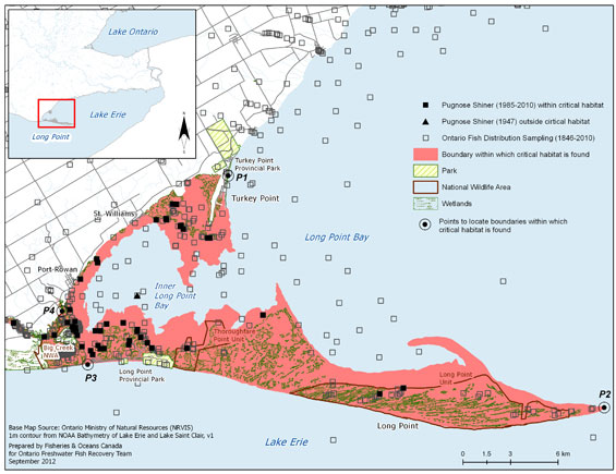
Long description of Figure 9a
Figure 9a is a map of Long Point and the Lake Erie shoreline up to, and east of, Turkey Point, with critical habitat identified (shaded in pink). These areas include the contiguous waters and wetlands of Big Creek and Long Point Bay and, in Long Point Bay, extend from the high water mark down to the 1 m contour. An inset illustrates the geographical location of the map on a larger scale map. Individual data points for capture of Pugnose Shiner (1985–2010; 1947) are shown, as well as sites for Ontario fish sampling (1846–2010). A legend and scale are provided.
Figure 9b. Area within which critical habitat is found for the Pugnose Shiner in Big Creek.
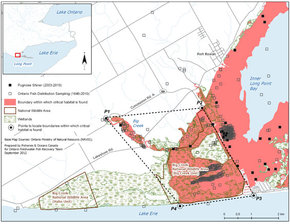
Long description of Figure 9b
Figure 9b is a map of Big Creek, the Big Creek National Wildlife Area, and surrounding areas, with critical habitat identified (shaded in pink). These areas include the contiguous waters and wetlands of Big Creek and Long Point Bay. In Big Creek, it includes all contiguous waters and wetlands from the causeway west to, and including, the Big Creek unit only of Big Creek National Wildlife Area, except habitat contained within the interior diked cell within the National Wildlife Area, and also including all contiguous wetlands to the north of Big Creek and the first two contiguous Aquatic Landscape Inventory System segments of Big Creek proper, extending to Concession A Rd. An inset illustrates the geographical location of the map on a larger scale map. Individual data points for capture of Pugnose Shiner (2003, 2009) are shown, as well as sites for Ontario fish sampling (1846–2010). A legend and scale are provided.
Wellers Bay
The area within which critical habitat is found has been identified as all contiguous waters and wetlands of Wellers Bay up to the high-water mark elevation for Lake Ontario at 75.32 m above sea level (International Great Lakes Datum 1985). This includes all occasionally exposed lands of Wellers Bay National Wildlife Area lying between the high-water mark (75.32 m above sea level) and the water’s edge of Wellers Bay, which forms the boundary of Wellers Bay National Wildlife Area, and which varies with water level fluctuations in Lake Ontario. The existing maintained, dredged, channel at the northwest end of Wellers Bay, which provides the only water access for Wellers Bay, is not included as an area within which critical habitat is found (Figure 10). The high-water mark may extend to areas that are dry due to low water levels and may extend higher where coastal wetlands exist and habitat function is connected to Lake Ontario. The area within which critical habitat is found represents an area of approximately 19 km².
Figure 10. Area within which critical habitat is found for the Pugnose Shiner in Wellers Bay.
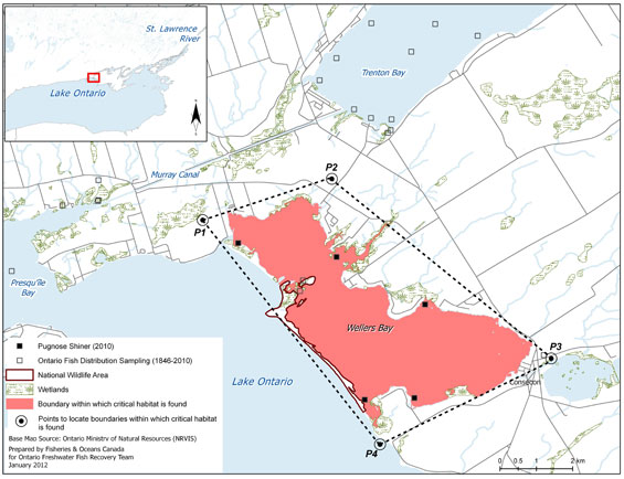
Long description of Figure 10
Figure 10is a map of Wellers Bay and a portion of the Lake Ontario shoreline, and surrounding areas, with critical habitat identified (shaded in pink). These areas include all contiguous waters and wetlands of Wellers Bay and Wellers Bay National Wildlife Area. An inset illustrates the geographical location of the map on a larger scale map. Individual data points for capture of Pugnose Shiner (2010) are shown, as well as sites for Ontario fish sampling (1846–2010). A legend and scale are provided.
West Lake and East Lake
The area within which critical habitat is found has been identified as all contiguous waters and wetlands of West Lake and East Lake (Figure 11), up to the high-water mark elevation for Lake Ontario at 75.32 m above sea level (International Great Lakes Datum 1985). The high-water mark may extend to areas that are dry due to low water levels and may extend higher where coastal wetlands exist and habitat function is connected to Lake Ontario. The area within which critical habitat is found includes the creek that flows into West Lake, upstream to the junction with Wesley Acres Road and the creek that flows into West Lake, upstream to the junction with Highway 12. This area within which critical habitat is found represents an area of approximately 19 km² in West Lake. The area within which critical habitat is found for East Lake also includes the creek that flows into East Lake from downstream of Highway 10. This area within which critical habitat is found represents an area of approximately 12 km² in East Lake.
Figure 11. Area within which critical habitat is found for the Pugnose Shiner in West Lake and East Lake.
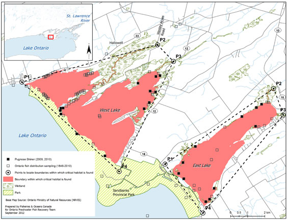
Long description of Figure 11
Figure 11 is a map of West Lake and East Lake, a portion of the Lake Ontario shoreline, and surrounding areas, with critical habitat identified (shaded in pink). These areas include all contiguous waters and wetlands of West Lake and East Lake including the creek that flows into West Lake, upstream to the junction with Wesley Acres Rd., and the creek that flows into East Lake. An inset illustrates the geographical location of the map on a larger scale map. Individual data points for capture of Pugnose Shiner (2009, 2010) are shown, as well as sites for Ontario fish sampling (1846–2010). A legend and scale are provided.
Waupoos Bay
The area within which critical habitat is found has been identified as all contiguous waters and wetlands of Waupoos Bay (Figure 12), up to the high-water mark elevation for Lake Ontario at 75.32 m above sea level (International Great Lakes Datum 1985) and down to the 2 m contour. The high-water mark may extend to areas that are dry due to low water levels and may extend higher where coastal wetlands exist and habitat function is connected to Lake Ontario. The area within which critical habitat is found represents an area of approximately 1.6 km².
Figure 12. Area within which critical habitat is found for the Pugnose Shiner in Waupoos Bay.
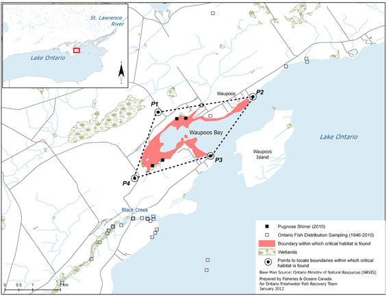
Long description of Figure 12
Figure 12 is a map of Waupoos Bay, a portion of the Lake Ontario shoreline, and surrounding areas, with critical habitat identified (shaded in pink). These areas include all contiguous waters and wetlands of Waupoos Bay from the high water mark down to the 2 m contour. An inset illustrates the geographical location of the map on a larger scale map. Individual data points for capture of Pugnose Shiner (2010) are shown, as well as sites for Ontario fish sampling (1846–2010). A legend and scale are provided.
St. Lawrence River/St. Lawrence Islands National Park
The area within which critical habitat is found includes all contiguous waters and wetlands, down to the 3 m contour and up to the high water mark elevation for Lake Ontario at 75.32 m above sea level (International Great Lakes Datum 1985). The high-water mark may extend to areas that are dry due to low water levels and may extend higher where coastal wetlands exist and habitat function is connected to Lake Ontario. The area within which critical habitat is found extends downstream from just southwest of Eastview to just northeast of Mallorytown Landing, south to the Canada/U.S. border, and including the mouth of the Gananoque River up to the dam above Highway 2 (Figures 13a and 13b). This represents an area of approximately 44 km².
Figure 13a. Area within which critical habitat is found for the Pugnose Shiner in the St. Lawrence River.
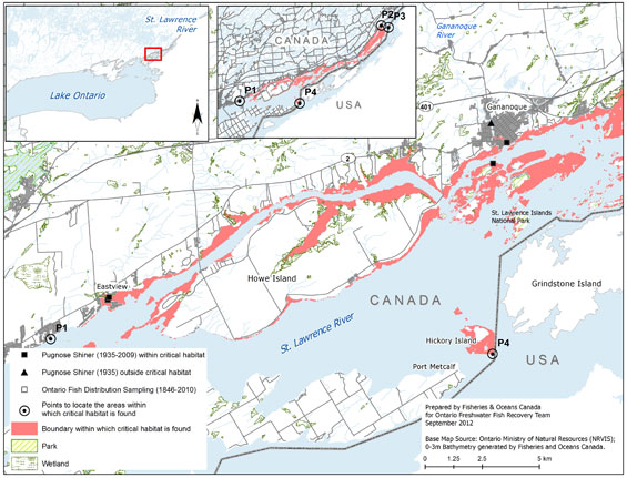
Long description of Figure 13a
Figure 13a is a map of the St. Lawrence River, just downstream of the eastern end of Lake Ontario, in the vicinity of Howe Island from Eastview to just downstream of Gananoque. Critical habitat identified (shaded in pink), as shown in both maps, includes all contiguous waters and wetlands and extends downstream from just south-west of Eastview to just north-east of Mallorytown Landing, south to the Canada/U.S. border and including the mouth of the Gananoque River up to the dam above Hwy #2. An inset for each map illustrates the geographical location of the map on a larger scale map. Individual data points for capture of Pugnose Shiner (1935–2009, 1935) are shown, as well as sites for Ontario fish sampling (1846–2010). A legend and scale are provided on each map.
Figure 13b. Area within which critical habitat is found for the Pugnose Shiner in the St. Lawrence River.

Long description of Figure 13b
Figure 13b shows the St. Lawrence River from Gananoque, downstream to Mallorytown Landing and vicinity. Critical habitat identified (shaded in pink), as shown in both maps, includes all contiguous waters and wetlands and extends downstream from just south-west of Eastview to just north-east of Mallorytown Landing, south to the Canada/U.S. border and including the mouth of the Gananoque River up to the dam above Hwy #2. An inset for each map illustrates the geographical location of the map on a larger scale map. Individual data points for capture of Pugnose Shiner (1935–2009, 1935) are shown, as well as sites for Ontario fish sampling (1846–2010). A legend and scale are provided on each map.
These identifications of areas within which critical habitat is found ensure that currently occupied habitat within the Teeswater River, Old Ausable Channel, Mouth Lake, St. Clair National Wildlife Area, Little Bear Creek, Long Point Bay/Big Creek, Wellers Bay, West Lake, East Lake, Waupoos Bay, and the St. Lawrence River/St. Lawrence Islands National Park will be protected, until such time as critical habitat for the species is further refined according to the schedule of studies (Section 2.7.5 Schedule of studies to identify critical habitat). The schedule of studies outlines activities necessary to refine the current critical habitat descriptions at confirmed extant locations, but will also apply to new locations should new locations with established populations be confirmed. Critical habitat descriptions will be refined as additional information becomes available to support the population and distribution objectives.
2.7.4.1 Population viability
The area within which critical habitat is found for each population was compared to the estimated (MAPV) for Pugnose Shiner in Canada (Table 11). It should be noted that for some populations, it is likely that only a portion of the habitat within that identified as the critical habitat would meet the functional habitat requirements of the species’ various life stages. In addition, since these populations occur in areas of degraded habitat (MAPV assumes habitat quality is optimal), areas larger than the MAPV may be required to support an MVP. Future studies may help quantify the amount and quality of available habitat within currently identified critical habitats for all populations; such information, along with the verification of the MAPV model, will allow greater certainty for the determination of population viability. As such, the results below are preliminary and should be interpreted with caution.
| Population15 | Area within which critical habitat is identified (km²) | Habitat type | MAPV area (km²) | MAPV achieved? |
|---|---|---|---|---|
| Teeswater River |
0.014
|
Lacustrine |
0.050
|
No
|
| Old Ausable Channel |
0.61
|
Riverine |
0.015
|
Yes
|
| Mouth Lake |
0.05
|
Lacustrine |
0.050
|
Unknown
|
| St. Clair National Wildlife Area |
1.24
|
Lacustrine |
0.050
|
Yes
|
| Little Bear Creek |
0.42
|
Riverine |
0.015
|
Yes
|
| Long Point Bay/Big Creek |
116.15
|
Lacustrine |
0.050
|
Yes
|
| Wellers Bay |
19.07
|
Lacustrine |
0.050
|
Yes
|
| West Lake |
19.32
|
Lacustrine |
0.050
|
Yes
|
| East Lake |
11.6
|
Lacustrine |
0.050
|
Yes
|
| Waupoos Bay |
1.6
|
Lacustrine |
0.050
|
Yes
|
| St. Lawrence River |
44.03
|
Riverine |
0.015
|
Yes
|
2.7.5 Schedule of studies to identify critical habitat
This recovery strategy includes an identification of critical habitat to the extent possible, based on the best available information. Further studies are required to refine critical habitat identified for the Pugnose Shiner to support the population and distribution objectives for the species. The activities listed in Table 12 are not exhaustive and it is likely that the process of investigating these actions will lead to further knowledge gaps that need to be addressed.
| Description of activity | Rationale | Approximate timeline |
|---|---|---|
| Conduct studies to determine the habitat requirements for all life stages (especially juvenile and YOY life stages). | There is little known about YOY and juvenile habitat requirements. Determining habitat requirements for each life stage will help identify all types of critical habitat for this species. | 2013-2015 |
| Survey and map habitat quality and quantity within historical and current sites, as well as sites adjacent to currently occupied habitat. | Strengthen confidence in data used to determine if sites meet the criteria to identify critical habitat; monitor current sites for changes in population data that may result in changes to critical habitat identification; surveying adjacent habitat ensures accuracy of area of occurrence, on which critical habitat is being partly defined. | 2013-2015 |
| Conduct additional species surveys to fill in distribution gaps, and to aid in determining population connectivity. | Additional populations and corresponding critical habitat may be required to meet the population and distribution objectives. | 2013-2015 |
| Create a population-habitat supply model for each life stage. | Will aid in developing recovery targets and determining the amount of critical habitat required by each life stage to meet these targets. | 2016-2017 |
| Based on information gathered, review population and distribution goals. Determine amount and configuration of critical habitat required to achieve goal if adequate information exists. Validate model. | Once the information above is gathered, recovery targets should be reviewed to ensure that they are still achievable and logical. Determining the amount and configuration of critical habitat based on recovery targets will be required for the Action Plan. | 2016-2017 |
Activities identified in this schedule of studies will be carried out through collaboration between DFO, relevant ecosystem recovery teams, and other groups and land managers. Note that many of the individual recovery approaches will address some of the information requirements listed above.
2.7.6 Examples of activities likely to result in the destruction of critical habitat
The critical habitat for the Pugnose Shiner will be legally protected through the application of subsection 58(1) of SARA, which prohibits the destruction of any part of the critical habitat of aquatic species listed as Endangered or Threatened, and any part of the critical habitat of aquatic species listed as Extirpated if a recovery strategy has recommended their reintroduction into the wild in Canada.
Activities that ultimately increase siltation/turbidity levels and/or result in the decrease of water quality or cause direct habitat modification can negatively impact Pugnose Shiner habitat. Without appropriate mitigation, direct destruction of habitat may result from work or activities such as those identified in Table 13.
The activities described in this Table are neither exhaustive nor exclusive and have been guided by the threats described in Section 1.5 (Threats). The absence of a specific human activity does not preclude the department’s ability to regulate it pursuant to SARA. Furthermore, the inclusion of an activity does not necessarily result in its prohibition since it is destruction of critical habitat that is prohibited. Since habitat use is often temporal in nature, every activity is assessed on a case-by-case basis and sitespecific mitigation measures are applied where they are reliable and available. In every case, where information is available, thresholds and limits are associated with attributes to better inform management and regulatory decision-making. However, in many cases the knowledge of a species and its critical habitat may be lacking and in particular, information associated with a species’ or habitat’s thresholds of tolerance to disturbance from human activities, is lacking and must be acquired.
| Activity | Effect - pathway | Function affected | Feature affected | Attribute affected |
|---|---|---|---|---|
| Habitat modifications: Dredging Placement of material or structures in water (e.g., groynes, piers, infilling, partial infills, jetties) Shoreline hardening |
Changes in bathymetry and shoreline morphology caused by dredging and nearshore grading and excavation can remove (or cover) preferred substrates, change water depths, change flow patterns potentially affecting nutrient levels and water temperatures. Placing material or structures in water reduces habitat availability (e.g., the footprint of the infill or structure is lost). Placing of fill can cover preferred substrates. Changing shoreline morphology can result in altered flow patterns, change sediment depositional areas, reduce oxygenation of substrates, cause erosion and alter turbidity levels. These changes can promote aquatic plant growth and cause changes to nutrient levels. Hardening of shorelines can reduce organic inputs into the water and alter water temperatures potentially affecting the availability of prey for this species. |
Spawning Nursery Feeding Cover |
Areas that seasonally support aquatic vegetation |
|
Habitat modifications:
|
Water extraction can affect surface water levels and flow, and groundwater inputs into streams and rivers, affecting habitat availability. Altered flow patterns can affect sediment deposition. |
Spawning Nursery Feeding Cover |
Areas that seasonally support aquatic vegetation |
|
Habitat modifications:
|
Resulting damage to shorelines, banks and watercourse bottoms from unfettered access by livestock can cause increased erosion and sedimentation, affecting substrate oxygenation and water temperatures. Such access can also increase organic nutrient inputs into the water, causing nutrient loading and potentially promoting algal blooms. |
Spawning Nursery Feeding Cover |
Areas that seasonally support aquatic vegetation |
|
Habitat modifications: Mechanical removal of riparian vegetation
|
Removal of riparian vegetation can cause erosion and increase turbidity, ultimately affecting preferred substrates and oxygenation of substrates. Water temperatures can also be negatively affected by removal of riparian vegetation and water velocities can be increased during high water events. | Spawning Nursery Feeding Cover |
Areas that seasonally support aquatic vegetation |
|
| Deliberate introduction of exotic species | Common Carp uproot aquatic vegetation and increase turbidity levels. Eurasian milfoil can grow in dense mats, blocking sunlight, increasing phosphorous and nitrogen levels, increasing temperature and may become too dense to be used by Pugnose Shiner for spawning. | Spawning Nursery Feeding Cover |
Areas that seasonally support aquatic vegetation |
|
| Nutrient loadings: Over-application of fertilizer and improper nutrient management (e.g., organic debris management, wastewater management, animal waste, septic systems and municipal sewage) |
Improper nutrient management can cause nutrient loading of nearby waterbodies. Elevated nutrient levels can cause increased aquatic plant growth changing water temperatures and slowly change preferred flows and substrates. Oxygen levels in substrates can also be negatively affected. | Spawning Nursery Feeding Cover |
Areas that seasonally support aquatic vegetation |
|
| Sediment loading and turbidity: Altered flow regimes causing erosion and changing sediment transport (e.g., tiling of agricultural drainage systems, removal of riparian zones) Work in or around water with improper sediment and erosion control (e.g., overland runoff from ploughed fields, use of industrial equipment, cleaning or maintenance of bridges or other structures) |
Improper sediment and erosion control or mitigation can cause increased turbidity levels, changing preferred substrates and their oxygen levels, potentially reducing feeding success or prey availability, impacting the growth of aquatic vegetation and possibly excluding fish from habitat due to physiological impacts of sediment in the water (e.g., gill irritation). Also see: Habitat Modifications: Change in timing, duration and frequency of flow. |
Spawning Nursery Feeding Cover |
Areas that seasonally support aquatic vegetation |
|
| Aquatic vegetation removal: Vegetation clearing (mechanical and chemical removal) |
Removal of aquatic vegetation required by the species to spawn and for cover can negatively affect recruitment and predation success. Plant die-off following chemical treatments and the removal of plant material can also negatively impact water quality affecting turbidity and water temperatures. | Spawning Nursery Feeding Cover |
Areas that seasonally support aquatic vegetation |
|
Barriers such as dikes and dams at three locations (Old Ausable Channel, St. Clair National Wildlife Area and Big Creek National Wildlife Area) maintain habitat conditions for Pugnose Shiner populations. As such, the loss of these structures in these locations may result in the destruction of critical habitat.
Certain habitat management activities are recognized as being beneficial to the long-term survival and/or recovery of the species and may be permitted under s.73 of SARA when required, as long as DFO is satisfied that the conditions of s.73 can be met. Such activities may include, but are not limited to, the removal/control of exotic aquatic/semi-aquatic vegetation, water level management (including dike maintenance) and habitat restoration activities (e.g., fire management). For example, in National Wildlife Areas, water levels may be managed and some aquatic vegetation may be removed, to maintain hemi-marsh conditions (i.e., 50/50 emergent/open water habitat). Big Creek National Wildlife Area and St. Clair National Wildlife Area, have been diked and have had ongoing water level/aquatic vegetation management (approximately once a decade) for the past 25 to 60 years (J. Robinson, Canadian Wildlife Service, pers. comm. 2008). Short-term water level draw-downs result in improved habitat conditions for waterfowl and, despite the obvious loss of habitat in the short term, also appear to improve habitat conditions for Pugnose Shiner in the long term. However, the impacts to the population and its long-term viability are unknown and require further investigation. In future, research will inform such water management approaches to minimize short-term impacts to existing Pugnose Shiner populations. Many other restoration activities that improve the quality and/or quantity of available wetland habitat for the Pugnose Shiner may be necessary.
Note that in cases where critical habitats of multiple species occur, as in National Wildlife Areas, that an ecosystem approach to the management of habitat is required to maximize benefit to co-occurring species at risk (of all taxa, including fishes, birds, reptiles, etc). Such an approach would require multi-jurisdictional discussions and recognizes that negative impacts to some species and their habitats may result from habitat management practices aimed at achieving an overall net benefit to the ecosystem and the species at risk that it supports. This approach could be formalized within a management plan for the relevant National Wildlife Areas, developed by Environment Canada in consultation with DFO.
2.8 Existing and recommended approaches to habitat protection
When the Canadian Environmental Assessment Act, 2012 (CEAA 2012) applies and a species at risk has been identified as a valued ecosystem component within the scope of the review pursuant to that Act, the environmental assessment will take into account, any change that might be caused to aquatic species as defined in s.2(1) of SARA. Furthermore, under s.79 of SARA, during an environmental assessment of a project under CEAA 2012, the competent minister must be notified if the project will affect a listed wildlife species or its critical habitat. Once identified, SARA includes provisions to prevent the destruction of critical habitat of the Pugnose Shiner.
The critical habitat of Pugnose Shiner in the St. Clair, Big Creek, and Long Point National Wildlife Areas will be protected by the prohibition against destruction of critical habitat, pursuant to subsection 58(2) of the SARA, 90 days after the description of critical habitat as identified in the recovery strategy is published in the Canada Gazette. This prohibition provides additional protection to that already afforded and available under the Canada Wildlife Act, as well as the Wildlife Area Regulation associated with this statute.
Provincial
Provincially, protection is also afforded under the Planning Act. Planning authorities are required to be “consistent with” the provincial Policy Statement under Section 3 of Ontario’s Planning Act, which prohibits development and site alteration in the habitat of Endangered or Threatened species. Stream-side development in Ontario is managed through floodplain regulations enforced by local conservation authorities. Under the Public Lands Act, a permit may be required for work in the water and along the shore. In the Ausable River watershed, the majority of the Old Ausable Channel, where Pugnose Shiner occurs, is protected within the boundaries of Pinery Provincial Park, conferring some degree of protection from development pressures and activities through the Provincial Parks and Conservation Reserves Act. Additionally, the entire Old Ausable Channel was designated as a Provincially Significant Wetland in 2008 by the OMNR (K. Jean, ABCA, pers. comm.).
The Pugnose Shiner is listed as an Endangered species under Ontario’s Endangered Species Act, 2007. Under the Act, the species itself is currently protected and the habitat of Pugnose Shiner will be protected under the general habitat protection provisions of the Act as of June 30, 2013 unless a specific habitat regulation is developed by the provincial government at an earlier date.
2.9 Effects on other species
Pugnose Shiner habitat is shared by many other species, including multiple species at risk. These include not only aquatic species but also a number of amphibians, turtles, plants, and birds. While some of the proposed recovery activities will benefit the environment in general and are expected to positively affect other sympatric native species, there could be consequences to those species whose requirements may differ from those of Pugnose Shiner. Thus, it is important that habitat management activities for Pugnose Shiner be considered through the development, with input from responsible jurisdictions, of multi-species plans, ecosystem-based recovery programs, or area management plans that take into account the needs of multiple species, including other species at risk.
Many of the stewardship and habitat improvement activities will be implemented through existing ecosystem-based recovery programs that have already taken into account the needs of other species at risk. No negative impacts on other species resulting from implementation of Pugnose Shiner recovery actions are expected.
2.10 Recommended approach for recovery implementation
The recovery team recommends a dual approach to recovery implementation that combines an ecosystem-based approach with a single-species focus. This will be accomplished by working closely with existing ecosystem recovery teams to combine efficiencies and share knowledge on recovery initiatives. There are currently three aquatic ecosystem-based recovery strategies (Ausable River, Essex-Erie region, and Walpole Island) being implemented that address several populations of Pugnose Shiner. Pugnose Shiner populations also occur outside the boundaries of existing ecosystem-based recovery programs in Lake St. Clair, Wellers Bay, West Lake, East Lake, Waupoos Bay, the St. Lawrence River/St. Lawrence Islands National Park, and the Teeswater River. A single-species approach to recovery will facilitate implementation of recovery actions within these watersheds through partnerships with local watershed management and stewardship agencies. If ecosystem-based recovery initiatives are developed in the future for these watersheds, the present single-species strategy will provide a strong foundation to build upon.
2.11 Statement on action plans
Action plans are documents that describe, among other things, the activities designed to achieve the population and distribution objectives identified in the recovery strategy. Under SARA, an action plan provides the detailed recovery planning that supports the strategic direction set out in the recovery strategy for the species. The plan outlines what needs to be done to achieve the population and distribution objectives identified in the recovery strategy, including the measures to be taken to address the threats and monitor the recovery of the species, as well as the measures to protect critical habitat. Action plans offer an opportunity to involve many interests in working together to find creative solutions to recovery challenges.
One or more action plans relating to this recovery strategy will be produced within five years of the final strategy being posted to the Species at Risk Public Registry.
3. References
ARRT (Ausable River Recovery Team). 2006. Recovery strategy for species at risk in the Ausable River: an ecosystem approach, 2005-2010. Draft Recovery Strategy submitted to RENEW Secretariat.
Bailey, R.M. 1959. Distribution of the American cyprinid fish Notropis anogenus. Copeia 1959 (2):119-123.
Becker, G.C. 1983. Fishes of Wisconsin. University of Wisconsin Press, Madison, Wisconsin. 1052 pp.
Bouvier, L.D., A.L. Boyko, and N.E. Mandrak. 2010. Information in support of a Recovery Potential Assessment of Pugnose Shiner (Notropis anogenus) in Canada. DFO Canadian Science Advisory Secretariat Research Document 2010/009. vi + 23 pp.
Bowles, J.M. 2005. Walpole Island ecosystem recovery strategy – Draft 8. Prepared for Walpole Island Heritage Centre, Environment Canada and the Walpole Island Recovery Team. vii + 43 pp.
Bryan, S.D., A.T. Robinson, and M.G. Sweetser. 2002. Behavioural responses of a small native fish to multiple introduced predators. Environmental Biology of Fishes 63: 49-56.
Carlson, D.M. 1997. Status of the Pugnose and Blackchin Shiners in the St. Lawrence River in New York, 1993-95. Journal of Freshwater Ecology 12:131-139.
COSEWIC (Committee on the Status of Endangered Wildlife in Canada). 2011. COSEWIC's assessment process and criteria, November 2011. (Accessed: September 2012)
Cudmore, B. and N.E. Mandrak. 2011. The baitfish primer – a guide to identifying and protecting Ontario’s baitfishes. Fisheries and Oceans Canada 40 pp.
DeMarais, B.D. and W.L. Minckley. 1993. Genetics and morphology of Yaqui Chub, Gila purpurea, an endangered cyprinid fish subject to recovery efforts. Biological Conservation 66:195-206.
Detenbeck, N.E., S.M. Galatowitsch, J. Atkinson, and H. Ball. 1999. Evaluating perturbations and developing restoration strategies for inland wetlands in the Great Lakes Basin. Wetlands 19:789-820.
EERT(Essex-Erie Recovery Team). 2008. Recovery strategy for the fishes at risk of the Essex-Erie region: an ecosystem approach. Prepared for the Department of Fisheries and Oceans. July 2008 – Draft.
Eddy, S., and J.C. Underhill. 1974. Northern fishes: with special reference to the upper Mississippi Valley. University of Minnesota Press, Minneapolis, MN. 414 pp.
Environment Canada. 2012. Eurasian watermilfoil, Myriophyllum spicatum. St. Lawrence Centre. Biological Information website. (accessed: March 2007).
Gilbert, J., G. Dunn, and B. Locke. 2007. Rondeau Bay ecological assessment report. Report prepared for the Ontario Ministry of Natural Resources. May 2007.
Goldstein, R.M., and T.P. Simon. 1999. Toward a united definition of guild structure for feeding ecology of North American freshwater fishes. pp. 123–202. In: Assessing the sustainability and biological integrity of water resources using fish communities. Edited by T.P. Simon. CRC Press, New York, NY, USA.
Hanna, E. 1984. Restoration of aquatic vegetation in Rondeau Bay, Lake Erie. The Plant Press 2: 99-101.
Holm, E., and D.Boehm. 1998. Sampling for fishes at risk in southwestern Ontario. Unpublished report prepared by the Centre for Biodiversity and Conservation Biology, Royal Ontario Museum, for the Ontario Ministry of Natural Resources, Southcentral Region and Aylmer District. Revised 2001.
Holm, E., and N.E. Mandrak. 2002. Update COSEWICstatus report on the Pugnose Shiner, Notropis anogenus, in Canada, In COSEWICassessment and update status report on the Pugnose Shiner, Notropis anogenus, in Canada. Committee on the Status of Endangered Wildlife in Canada. Ottawa. 15 pp.
Lane, J.A., C.B. Portt, and C.K. Minns. 1996a. Spawning habitat characteristics of Great Lakes fishes. Canadian Manuscript Report of Fisheries and Aquatic Sciences 2368: v + 48 pp.
Lane, J.A., C.B. Portt, and C.K. Minns. 1996b. Nursery habitat characteristics of Great Lakes fishes. Canadian Manuscript Report of Fisheries and Aquatic Sciences 2338: v + 42 pp.
Lemmen, D.S. and F.J. Warren. 2004. Climate change impacts and adaptation: a Canadian perspective. Natural Resources Canada: Ottawa, Ontario.
Leslie, J.K., and C.A. Timmins. 2002. Description of age 0 juvenile Pugnose Minnow, Opsopoeodus emiliae (Hay), and Pugnose Shiner, Notropis anogenus (Forbes), in Ontario. Canadian Technical Report of Fisheries and Aquatic Sciences 2397: iii + 11 pp.
Lougheed, V.L., T. Theÿsmeÿer, T. Smith, and P. Chow-Fraser. 2004. Carp exclusion, food-web interactions, and the restoration of Cootes Paradise Marsh. Journal of Great Lakes Research 30: 44-57.
Lyons, J. 1989. Changes in the abundance of small littoral-zone fishes in Lake Mendota, Wisconsin. Canadian Journal of Zoology 67:2910-2916.
Mandrak, N.E., J. Barnucz, and D. Marson. 2006a. Survey of the fish assemblages of St. Lawrence Islands National Park in 2005. Canadian Manuscript Report of Fisheries and Aquatic Sciences 2777: v + 17 pp.
Mandrak, N.E., J. Barnucz, D. Marson, and G.J. Velema. 2006b. Targeted, wadeable sampling of fish species at risk in the Lake St. Clair watershed of southern Ontario, 2003. Canadian Manuscript Report of Fisheries and Aquatic Sciences 2779: v + 26 pp.
Marson, D., N.E. Mandrak, and D.A.R. Drake. 2009. Sampling of the fish communities in the Saugeen River watershed, 2005-2006. Canadian Manuscript Report of Fisheries and Aquatic Sciences 2919: vii + 19 pp.
Marson, D., J. Barnucz, and N.E. Mandrak. 2010. Fish community sampling in National Wildlife Areas in southwestern Ontario, 2002-2005. Canadian Manuscript Report of Fisheries and Aquatic Sciences 2918: v + 47 pp.
NatureServe. 2012. NatureServe explorer: an online encyclopedia of life. Version 7.1 NatureServe, Arlington, Virginia. (accessed: September 1, 2012).
Nelson, M. 2006. Towards a recovery strategy for fishes at risk of the Essex-Erie region: synthesis of background Information. Prepared for the Essex-Erie Recovery Team. Draft 4 – September 2006.
Nelson, M.R. and S.K. Staton. 2007. Draft. Targeted surveys for endangered and threatened fishes of the Essex-Erie region. Canadian Manuscript Report of Fisheries and Aquatic Sciences.
OMNR(Ontario Ministry of Natural Resources). 2006. Lake Ontario Management Unit Report.
OMNR(Ontario Ministry of Natural Resources). 2011. Ontario fishing regulations – permitted baitfish species. (Accessed: November 2011).
Page, L.M., and B.M. Burr. 1991. A field guide to freshwater fishes of North America north of Mexico. Houghton Mifflin Company, Boston, Massachusetts. 432 pp.
Parker, B., P. McKee, and R.R. Campbell. 1985. COSEWICstatus report on the Pugnose Shiner, Notropis anogenus, in Canada. Committee on the Status of Endangered Wildlife in Canada. Ottawa. 14 pp.
Parker, B., P. McKee, and R.R. Campbell. 1987. Status of the Pugnose Shiner, Notropis anogenus, in Canada. Canadian Field Naturalist 101: 208-212.
Portt, C.B., G.A. Coker, N.E. Mandrak and D.L. Ming. 2008. Protocol for the detection of fish Species At Risk in Ontario Great Lakes Area (OGLA). Canadian Science Advisory Secretariat Research Document 2008/026. v + 31 pp.
Scott, W.B., and E.J. Crossman. 1998. Freshwater fishes of Canada. Bulletin 184, Fisheries Research Board of Canada. 966 pp.
Smith, C.L. 1985. Inland fishes of New York State. New York State Department of Environmental Conservation, Albany, New York. 522 pp.
Stanfield, L. and R. Kuyvenhoven. 2005. Protocol for applications used in the Aquatic Landscape Inventory software application for delineating, characterizing and classifying valley segments within the Great Lakes basin. Ontario Ministry of Natural Resources Report, July 27, 2005.
Surette, H.J. 2006. Processes influencing temporal variation in fish species composition in Point Pelee National Park. Thesis (M.Sc.). University of Guelph, Guelph, ON. 105 pp.
Trautman, M.B. 1981. The fishes of Ohio. Ohio State University Press, Columbus, OH. 782 pp.
Vélez-Espino, L.A., R.G. Randall, M.A. Koops. 2008. Quantifying habitat requirements of four freshwater species at risk in Canada: Northern Madtom, Spotted Gar, Lake Chubsucker, and Pugnose Shiner. Canadian Science Advisory Secretariat Research Document 2009/115. iv + 21 pp.
Venturelli, P.A., L.A. Vélez-Espino, and M.A. Koops. 2010. Recovery potential modelling of Pugnose Shiner (Notropis anogenus) in Canada. Fisheries and Oceans Canada. Canadian Science Advisory Secretariat Research Document 2010/007. iv + 22 pp.
Whittier, T.R., D.B. Halliwell, and S.G. Paulsen. 1997. Cyprinid distributions in Northeast USA lakes: evidence of regional-scale minnow biodiversity losses. Canadian Journal of Fisheries and Aquatic Sciences 54: 1593-1607.
4. Recovery team members
The following individuals were involved in the development of the recovery strategy for the Pugnose Shiner:
- Muriel Andreae - St. Clair Region Conservation Authority (distribution list only)
- Tom Beaubiah - Cataraqui Region Conservation Authority (distribution list only)
- Lynn Bouvier - Fisheries and Oceans Canada
- Amy Boyko (Chair) - Fisheries and Oceans Canada
- Don Bucholtz - Ontario Parks (distribution list only)
- Andrea Doherty (Chair) - Fisheries and Oceans Canada
- Alan Dextrase - Ontario Ministry of Natural Resources
- Mark Ferguson - Fisheries and Oceans Canada
- Trevor Friesen - Ontario Ministry of Natural Resources
- Kari Jean - Ausable Bayfield Conservation Authority
- Brian Locke - Ontario Ministry of Natural Resources
- Dr. Nicholas Mandrak - Fisheries and Oceans Canada
- Brad McNevin - Quinte Conservation Authority (distribution list only)
- Mike Nelson - Essex Region Conservation Authority
- Dr. Scott Reid - Ontario Ministry of Natural Resources (formerly Trent University)
- Jeff Robinson - Environment Canada (Canadian Wildlife Service)
- Katie Stammler - University of Western Ontario
- Shawn Staton - Fisheries and Oceans Canada
- Josh Van Wieren - Parks Canada Agency (St. Lawrence Islands National Park)
- Mari Veliz - Ausable Bayfield Conservation Authority
- Shannon Wood - Saugeen Valley Conservation Authority
Appendix 1
Definition of Status Rankings
G-Rank (global): Rank assigned to an element based on its range-wide conservation status rank (G1 to G5, in decreasing order of priority). Elements ranked G1, G2, or G3 are considered imperilled. G-rank is assigned by NatureServe or the conservation data centre responsible for the element in question.
N-Rank (national): Rank assigned to an element based on its national conservation status rank (N1 to N5, in decreasing order of priority). Elements ranked N1, N2, or N3 are considered imperilled.
S-Rank (subnational): Rank assigned to element based on its provincial or state conservation status rank (S1 to S5, in decreasing order of priority. ,Elements ranked S1, S2 or S3 are considered imperilled).
Priority Ranking Value - Priority Ranking Definition
S1 (extremely rare) - usually 5 or fewer occurrences in the province or very few remaining individuals; often especially vulnerable to extirpation.
S2 (very rare) - usually between 5 and 20 occurrences in the province or with many individuals in fewer occurrences; often susceptible to extirpation.
S3 (rare to uncommon) - usually between 20 and 100 occurrences in the province; may have fewer occurrences, but with a large number of individuals in some populations; may be susceptible to large-scale disturbances.
S4 (common) - apparently secure in Ontario; usually with more than 100 occurrences in the province.
S5 (very common) - demonstrably secure in Ontario.
For more information on status ranks visit the Natural Heritage Information Centre.
1 Refer to Appendix 1 for definition of status rankings.
2 Note that, for lack of supporting data, a location was assumed to have a single population when population status was assessed by Bouvier et al. (2010).
3 Certainty: 1=quantitative analysis; 2=CPUE or standardized sampling; 3=best guess.
4 Population was not included in Bouvier et al.(2010).
5 Certainty: 1=causative studies; 2=correlative studies; and, 3=expert opinion.
6 Threat status revised from Bouvier et al. (2010) based on the expert opinion of J. Robinson, Environment Canada June 2010.
7 Pugnose Shiner were detected in four new locations after the recovery potential assessment was completed. Discussions with local conservation authorities, OMNR, Provincial Park staff, National Wildlife Area staff, and DFO staff, using the same criteria as Bouvier et al. (2010), determined threat status for these locations.
8 Draft Policy on the Feasibility of Recovery, Species at Risk Act Policy. January 2005.
9 Approaches currently being implemented by one or more ecosystem-based recovery programs (see Section 1.6 Actions already completed or underway).
10 Approaches currently being implemented by one or more ecosystem-based recovery programs (see Section 1.6 Actions already completed or underway).
11 Where known or supported by existing data.
12 All coordinates obtained using map datum NAD 83.
13 Riverine habitats are delineated to the midpoint of channel of the uppermost stream segment and lowermost stream segment (i.e., two points only).
14 The MAPV estimate is based on modelling approaches described in Section 2.7.2 (Information and methods used to identify critical habitat).
15 Note that some locations may contain more than one population (e.g., some of the larger areas such as Long Point Bay). In such cases, the MAPV would be applied to each individual population.
Important notice and disclaimer: DFO does not assume any responsibility for the quality of information, products or services listed in the Web sites provided above. Users should also be aware that information from external sources is available only in the language in which it was provided.