
Recovery Strategy for the Western Rattlesnake, the Great Basin Gophersnake and the Desert Nightsnake in Canada 2017
Recovery Strategy for the Western Rattlesnake (Crotalus oreganus), the Great Basin Gophersnake (Pituophis catenifer deserticola) and the Desert Nightsnake (Hypsiglena chlorophaea) in Canada
- Part 1 – Multi-species Federal Addition to the Recovery Plan for the Western Rattlesnake (Crotalus oreganus) in British Columbia, the Recovery Plan for the Gopher Snake, deserticola subspecies (Pituophis catenifer deserticola) in British Columbia and the Recovery Plan for the Desert Nightsnake (Hypsiglena chlorophaea) in British Columbia, prepared by Environment and Climate Change Canada
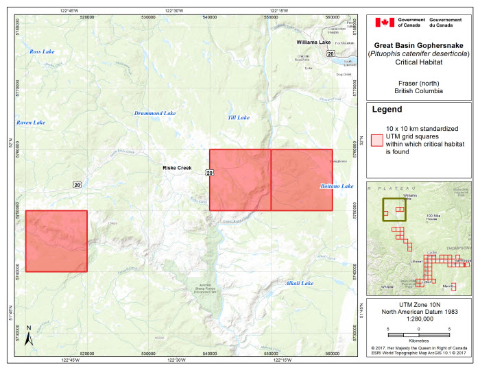
- Figure 1. Critical habitat for the Great Basin Gophersnake in the Fraser River area (north) in B.C. occurs within the 10 x 10 km standardized UTM grid squares where the criteria and methodology set out in section 1.1 are met. This standardized national grid system indicates the general geographic area within which critical habitat is found; detailed critical habitat mapping is not shown.
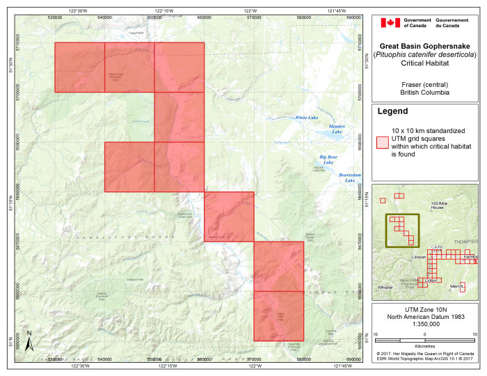
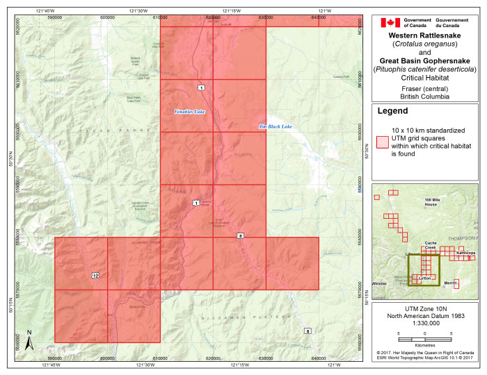
- Figure 2. Critical habitat for the Great Basin Gophersnake in the Fraser River area (central) in B.C. occurs within the 10 x 10 km standardized UTM grid squares where the criteria and methodology set out in section 1.1 are met. This standardized national grid system indicates the general geographic area within which critical habitat is found; detailed critical habitat mapping is not shown.
- Figure 3. Critical habitat for the Western Rattlesnake and the Great Basin Gophersnake in the Fraser-Thompson area, B.C. occurs within the 10 x 10 km standardized UTM grid squares where the criteria and methodology set out in section 1.1 are met. This standardized national grid system indicates the general geographic area within which critical habitat is found; detailed critical habitat mapping is not shown.
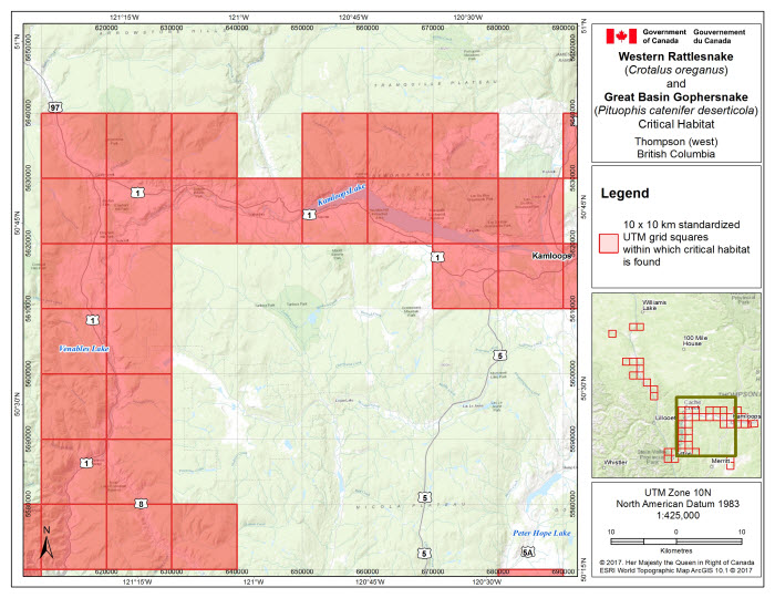
- Figure 4. Critical habitat for the Western Rattlesnake and the Great Basin Gophersnake in the Thompson area (west), B.C. occurs within the 10 x 10 km standardized UTM grid squares where the criteria and methodology set out in section 1.1 are met. This standardized national grid system indicates the general geographic area within which critical habitat is found; detailed critical habitat mapping is not shown.
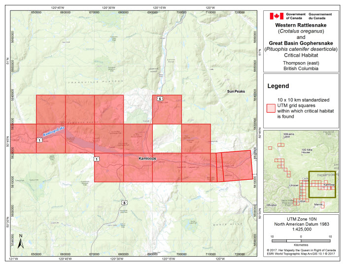
- Figure 5. Critical habitat for the Western Rattlesnake and the Great Basin Gophersnake in the Thompson area (east), B.C. occurs within the 10 x 10 km standardized UTM grid squares where the criteria and methodology set out in section 1.1 are met. This standardized national grid system indicates the general geographic area within which critical habitat is found; detailed critical habitat mapping is not shown.
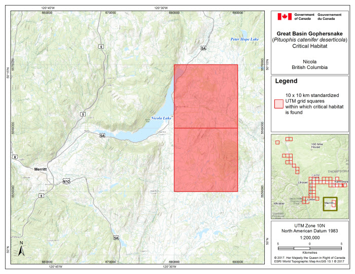
- Figure 6. Critical habitat for the Great Basin Gophersnake in the Nicola area, B.C. occurs within the 10 x 10 km standardized UTM grid squares where the criteria and methodology set out in section 1.1 are met. This standardized national grid system indicates the general geographic area within which critical habitat is found; detailed critical habitat mapping is not shown.
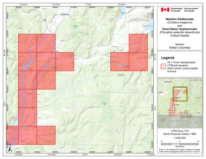
- Figure 7.Critical habitat for the Western Rattlesnake and the Great Basin Gophersnake in the Vernon area, B.C. occurs within the 10 x 10 km standardized UTM grid squares where the criteria and methodology set out in section 1.1 are met. This standardized national grid system indicates the general geographic area within which critical habitat is found; detailed critical habitat mapping is not shown.
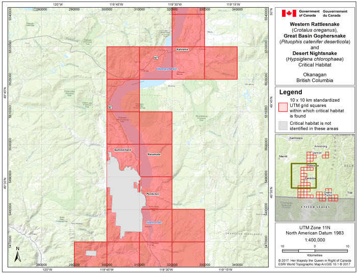
- Figure 8. Critical habitat for the Western Rattlesnake, the Great Basin Gophersnake and the Desert Nightsnake in the Okanagan area, B.C. occurs within the 10 x 10 km standardized UTM grid squares where the criteria and methodology set out in section 1.1 are met. This standardized national grid system indicates the general geographic area within which critical habitat is found; detailed critical habitat mapping is not shown.
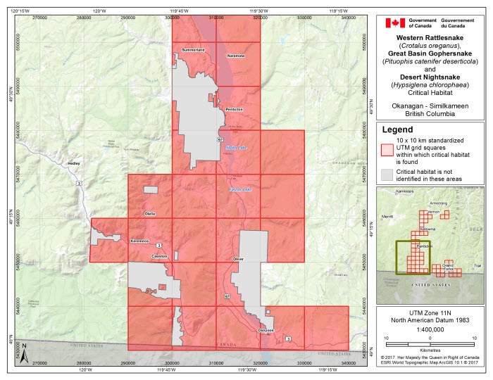
- Figure 9. Critical habitat for the Western Rattlesnake, the Great Basin Gophersnake and the Desert Nightsnake in the Okanagan-Similkameen area, B.C. occurs within the 10 x 10 km standardized UTM grid squares where the criteria and methodology set out in section 1.1 are met. This standardized national grid system indicates the general geographic area within which critical habitat is found; detailed critical habitat mapping is not shown.
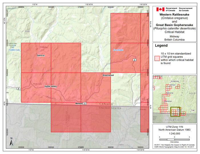
- Figure 10. Critical habitat for the Western Rattlesnake and the Great Basin Gophersnake in the Midway area, B.C. occurs within the 10 x 10 km standardized UTM grid squares where the criteria and methodology set out in section 1.1 are met. This standardized national grid system indicates the general geographic area within which critical habitat is found; detailed critical habitat mapping is not shown.
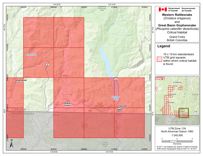
- Figure 11. Critical habitat for the Western Rattlesnake and the Great Basin Gophersnake in the Grand Forks area, B.C. occurs within the 10 x 10 km standardized UTM grid squares where the criteria and methodology set out in section 1.1 are met. This standardized national grid system indicates the general geographic area within which critical habitat is found; detailed critical habitat mapping is not shown.
- Tables 1. Summary of essential functions, biophysical features, and key attributes of Western Rattlesnake (CROR), Great Basin Gophersnake (PICA – core, connective), and Desert Nightsnake (HYCH) critical habitat.
- Tables 2. Schedule of Studies to Identify Critical Habitat for the Western Rattlesnake, the Great Basin Gophersnake and the Desert Nightsnake..
- Tables 3. Activities likely to result in destruction of critical habitat for the Western Rattlesnake (CROR), the Great Basin Gophersnake (PICA – core, connective), and the Desert Nightsnake (HYCH).
- Part 2 – Three adopted provincial recovery plans:
- A. Recovery Plan for the Western Rattlesnake (Crotalus oreganus) in British Columbia, prepared by the Southern Interior Reptile and Amphibian Working Group for the B.C. Ministry of Environment
- B. Recovery Plan for the Gopher Snake, deserticola subspecies (Pituophis catenifer deserticola) in British Columbia, prepared by the Southern Interior Reptile and Amphibian Working Group for the B.C. Ministry of Environment.
- C. Recovery Plan for the Desert Nightsnake (Hypsiglena chlorophaea) in British Columbia, prepared by the Southern Interior Reptile and Amphibian Working Group for the B.C. Ministry of Environment.
Recovery Strategy for the Western Rattlesnake (Crotalus oreganus), the Great Basin Gophersnake (Pituophis catenifer deserticola) and the Desert Nightsnake (Hypsiglena chlorophaea) in Canada
Environment and Climate Change Canada. 2017. Recovery Strategy for the Western Rattlesnake (Crotalus oreganus), the Great Basin Gophersnake (Pituophis catenifer deserticola) and the Desert Nightsnake (Hypsiglena chlorophaea) in Canada [Proposed]. Species at Risk Act Recovery Strategy Series. Environment and Climate Change Canada, Ottawa. Part 1, 28 pp., Part 2, A. 37 pp., B. 36 pp., C. 28 pp.
For copies of the recovery strategy, or for additional information on species at risk, including the Committee on the Status of Endangered Wildlife in Canada (COSEWIC) Status Reports, residence descriptions, action plans, and other related recovery documents, please visit the Species at Risk (SAR) Public Registry.
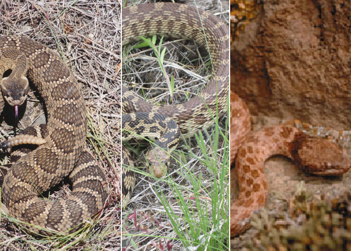
Cover illustration: © Karl W. Larsen (image of Western Rattlesnake - left); Kella Sadler, Environment and Climate Change Canada (image of Great Basin Gophersnake - center); Andrius Valadka (image of Desert Nightsnake - right).
Également disponible en français sous le titre « Programme de rétablissement du crotale de l’Ouest (Crotalus oreganus), de la couleuvre à nez mince du Grand Bassin (Pituophis catenifer deserticola) et de la couleuvre nocturne du désert (Hypsiglena chlorophaea) au Canada [Proposition] »
Content (excluding the illustrations) may be used without permission, with appropriate credit to the source.
Under the Accord for the Protection of Species at Risk (1996), the federal, provincial, and territorial governments agreed to work together on legislation, programs, and policies to protect wildlife species at risk throughout Canada.
In the spirit of cooperation of the Accord, the Government of British Columbia has given permission to the Government of Canada to adopt the Recovery Plan for the Western Rattlesnake (Crotalus oreganus) in British Columbia, the Recovery Plan for the Gopher Snake, deserticola subspecies (Pituophis catenifer deserticola) in British Columbia, and the Recovery Plan for the Desert Nightsnake (Hypsiglena chlorophaea) in British Columbia (Part 2) under Section 44 of the Species at Risk Act (SARA). Environment and Climate Change Canada has included a federal addition (Part 1) which completes the SARA requirements for this recovery strategy.
The federal recovery strategy for the Western Rattlesnake (Crotalus oreganus), the Great Basin Gophersnake (Pituophis catenifer deserticola) and the Desert Nightsnake (Hypsiglena chlorophaea) in Canada consists of two parts:
Part 1 – Multi-species federal addition to the Recovery Plan for the Western Rattlesnake (Crotalus oreganus) in British Columbia, the Recovery Plan for the Gopher Snake, deserticola subspecies (Pituophis catenifer deserticola) in British Columbia and the Recovery Plan for the Desert Nightsnake (Hypsiglena chlorophaea) in British Columbia, prepared by Environment and Climate Change Canada.
Part 2 – Three adopted provincial recovery plans:
- A. Recovery Plan for the Western Rattlesnake (Crotalus oreganus) in British Columbia, prepared by the Southern Interior Reptile and Amphibian Working Group for the B.C. Ministry of Environment.
- B. Recovery Plan for the Gopher Snake, deserticola subspecies (Pituophis catenifer deserticola) in British Columbia, prepared by the Southern Interior Reptile and Amphibian Working Group for the B.C. Ministry of Environment.
- C. Recovery Plan for the Desert Nightsnake (Hypsiglena chlorophaea) in British Columbia, prepared by the Southern Interior Reptile and Amphibian Working Group for the B.C. Ministry of Environment.
The federal, provincial, and territorial government signatories under the Accord for the Protection of Species at Risk (1996) agreed to establish complementary legislation and programs that provide for effective protection of species at risk throughout Canada. Under the Species at Risk Act (S.C. 2002, c.29) (SARA), the federal competent ministers are responsible for the preparation of recovery strategies for listed Extirpated, Endangered, and Threatened species and are required to report on progress within five years after the publication of the final document on the SAR Public Registry.
The Minister of Environment and Climate Change is the competent minister under SARA for the Western Rattlesnake (Crotalus oreganus), the Great Basin Gophersnake (Pituophis catenifer deserticola) and the Desert Nightsnake (Hypsiglena chlorophaea) and has prepared the federal component of this recovery strategy (Part 1), as per section 37 of SARA. To the extent possible, it has been prepared in cooperation with the Province of British Columbia as per section 39(1) of SARA. SARA section 44 allows the Minister to adopt all or part of an existing plan for the species if it meets the requirements under SARA for content (sub-sections 41(1) or (2)). The Province of British Columbia provided the attached recovery plans for the Snakes of the British Columbia Southern Interior - Western Rattlesnake, Great Basin Gophersnake and Desert Nightsnake (Part 2) as science advice to the jurisdictions responsible for managing the species in British Columbia. It was prepared in cooperation with Environment and Climate Change Canada.
Success in the recovery of this species depends on the commitment and cooperation of many different constituencies that will be involved in implementing the directions set out in this strategy and will not be achieved by Environment and Climate Change Canada, or any other jurisdiction alone. All Canadians are invited to join in supporting and implementing this strategy for the benefit of the Western Rattlesnake, Great Basin Gophersnake, Desert Nightsnake and Canadian society as a whole.
This recovery strategy will be followed by one or more action plans that will provide information on recovery measures to be taken by Environment and Climate Change Canada and other jurisdictions and/or organizations involved in the conservation of the species. Implementation of this strategy is subject to appropriations, priorities, and budgetary constraints of the participating jurisdictions and organizations.
The recovery strategy sets the strategic direction to arrest or reverse the decline of the species, including identification of critical habitat to the extent possible. It provides all Canadians with information to help take action on species conservation. When critical habitat is identified, either in a recovery strategy or an action plan, SARA requires that critical habitat then be protected.
In the case of critical habitat identified for terrestrial species including migratory birds SARA requires that critical habitat identified in a federally protected areaFootnote1 be described in the Canada Gazette within 90 days after the recovery strategy or action plan that identified the critical habitat is included in the public registry. A prohibition against destruction of critical habitat under ss. 58(1) will apply 90 days after the description of the critical habitat is published in the Canada Gazette.
For critical habitat located on other federal lands, the competent minister must either make a statement on existing legal protection or make an order so that the prohibition against destruction of critical habitat applies.
If the critical habitat for a migratory bird is not within a federal protected area and is not on federal land, within the exclusive economic zone or on the continental shelf of Canada, the prohibition against destruction can only apply to those portions of the critical habitat that are habitat to which the Migratory Birds Convention Act, 1994 applies as per SARA ss. 58(5.1) and ss. 58(5.2).
For any part of critical habitat located on non-federal lands, if the competent minister forms the opinion that any portion of critical habitat is not protected by provisions in or measures under SARA or other Acts of Parliament, or the laws of the province or territory, SARA requires that the Minister recommend that the Governor in Council make an order to prohibit destruction of critical habitat. The discretion to protect critical habitat on non-federal lands that is not otherwise protected rests with the Governor in Council.
The development of this recovery strategy addition was coordinated by Kella Sadler, Matt Huntley, and David Cunnington (Environment and Climate Change Canada, Canadian Wildlife Service - Pacific Region (ECCC CWS-PAC)). Astrid van Woudenberg (Cascadia Natural Resource Consultants Inc.) compiled information for the first draft of this recovery strategy under contract with Environment and Climate Change Canada. Substantial input and/or collaborative support was provided by Kim Borg (ECCC CWS – National Capital Region), and a working group of species’ experts including Orville Dyer and Robyn Reudink (B.C. Ministry of Forests, Lands and Natural Resource Operations), Christine Bishop (ECCC – Science and Technology), Jared Hobbs (Hemmera Envirochem Inc.), Mike Sarrell (Ophiuchus Consulting) and Purnima Govindarajulu (B.C. Ministry of Environment). Danielle Yu, Jeffrey Thomas, Sean Butler, and Meaghan Leslie-Gottschligg (ECCC CWS – PAC) provided additional assistance with mapping and figure preparation.
The following sections have been included to address specific requirements of the federal Species at Risk Act (SARA) that are not addressed, or which need more detailed comments, in the Recovery Plan for the Western Rattlesnake (Crotalus oreganus) in British Columbia, the Recovery Plan for the Gopher Snake, deserticola subspecies (Pituophis catenifer deserticola) in British Columbia and the Recovery Plan for the Desert Nightsnake (Hypsiglena chlorophaea) in British Columbia (Part 2 of this document, referred to henceforth as “the provincial recovery plans”, or “the provincial recovery plan” as appropriate) and/or to provide updated or additional information.
Under SARA, there are specific requirements and processes set out regarding the protection of critical habitat. Therefore, statements in the provincial recovery plan referring to protection of survival/recovery habitat may not directly correspond to federal requirements. Recovery measures dealing with the protection of habitat are adopted; however, whether these measures will result in protection of critical habitat under SARA will be assessed following publication of the final federal recovery strategy.
This section replaces the “Section 7.2: Spatial Description of the Species’ Survival/Recovery Habitat” section in the provincial recovery plans.
Section 41 (1)(c) of SARA requires that recovery strategies include an identification of the species’ critical habitat, to the extent possible, as well as examples of activities that are likely to result in its destruction. The provincial recovery plans for the Western Rattlesnake, the Great Basin Gophersnake and the Desert Nightsnake each include a description of the biophysical attributes of survival/recovery habitat. This science advice was used to inform the following critical habitat sections in this federal recovery strategy.
Critical habitat can only be partially identified at this time for the Western Rattlesnake, the Great Basin Gophersnake, and the Desert Nightsnake, owing to (i) the extent of location uncertainty associated with a portion of dens and/or occurrence records (applies to all species), (ii) incomplete information about the actual area of occupancy (owing to lack of applied focused search effort throughout the species ranges) (applies to all species), (iii) further work with applicable organizations is required to secure the necessary information for portions of the South Okanagan Valley and Lower Similkameen Valley (applies to all species), and (iv) unavailable and inadequate information about dispersal habitat needed by the Western Rattlesnake and the Desert Nightsnake.
The schedule of studies (Section 1.2) outlines the activities required to complete the identification of additional critical habitat necessary to support the population and distribution objectivesFootnote 2 for these species. Critical habitat for the Western Rattlesnake, the Great Basin Gophersnake and the Desert Nightsnake is identified in this document to the extent possible; as responsible jurisdictions and/or other interested parties conduct research to address knowledge gaps, the existing critical habitat methodology and identification may be modified and/or refined to reflect new knowledge.
Western Rattlesnakes, Great Basin Gophersnakes and Desert Nightsnakes all require both dens (hibernaculaFootnote3) and surrounding terrestrial habitat (for active-season use, such as foraging, gestation and/or egg-laying, basking, shedding, and refuge) to complete their life history functions. These species also require habitat for longer distance dispersal, to allow for colonization of new sites and/or movement between sites. Dispersal movements support gene flow and long-term persistence of viable populations of snakes within the landscape.
Western Rattlesnakes, Great Basin Gophersnakes and Desert Nightsnakes share some similarities in regards to habitat requirements, threats, and geographic distribution within the British Columbia southern interior. For example, all three species are known to utilize portions of the same active season habitat, and have been observed sharing hibernacula (Radke 1989; Gregory 2001; B.C. Conservation Data Centre 2014). Therefore, a multi-species approach in recovery planning is considered appropriate. Critical habitat is identified by applying a similar methodology for each species, as outlined below.
Geospatial locations of areas containing critical habitat for the Western Rattlesnake are based on locations of known hibernacula, whereas geospatial locations of areas containing critical habitat for the Great Basin Gophersnake and the Desert Nightsnake are based on all known occurrence records. This difference is applied owing to the fact that the Western Rattlesnake uses permanent rock features as hibernacula, with considerable site fidelity, i.e., often returning to the same hibernacula each fall (Didiuk et al. 2004). Western Rattlesnake hibernacula typically harbour relatively high numbers of individuals, often of multiple snake species, and can persist for over 100 years (COSEWIC 2013).
The Great Basin Gophersnake and the Desert Nightsnake are known to share hibernacula with the Western Rattlesnake in rock outcrops and talus slopes, and thus critical habitat based on known Western Rattlesnake hibernacula sites will encompass some of the critical habitat requirements for these species. However, while Great Basin Gophersnakes can utilize the same hibernacula as Western Rattlesnakes, they show a weaker association to rock habitats overall, and commonly utilize earthen burrow dens as over-wintering sites (Bertram et al. 2001; White 2008; Williams et al. 2015). Earthen dens are less stable and less identifiable features, and are less frequently re-used; therefore an occurrence-based approach is deemed appropriate for records not associated with known hibernacula. Desert Nightsnakes will use the same hibernacula as Western Rattlesnakes but less is known about Desert Nightsnake over-wintering in B.C. and therefore an occurrence-based approach is considered appropriate likewise, for records not associated with known hibernacula.
Western Rattlesnake
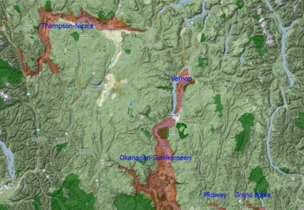
Critical habitat for the Western Rattlesnake is identified in five geographic areas of southern interior British Columbia. These five geographic areas align with those described in the provincial recovery plan for the Western Rattlesnake (i.e., Figure 3 of that document):
- Thompson-Nicola
- Vernon
- Okanagan - Similkameen
- Midway
- Grand Forks
Critical habitat for the Western Rattlesnake is based on all hibernaculaFootnote4 documented for the species. The area of terrestrial habitat that is used by the Western Rattlesnake over the course of an active season is estimated as approximately 2.8 km distance around hibernacula (Gomez 2007; Lomas 2013; Harvey 2015; see also section 3.3.2 of the provincial recovery plan for related discussion about seasonal movements of the Western Rattlesnake). Habitat for longer distance dispersal movements is also required for survival and recovery, however very little is known about long distance dispersal of this species in B.C. The longest recorded movement in B.C. is about 4 km within a home range (Harvey 2015), but it is considered likely that dispersal distances can be greater than 4 km, depending on habitat suitability (noting species’ needs for dispersal may or may not be different than what is required for regular seasonal use). Due to this knowledge gap regarding longer distance dispersal, connective habitat for the Western Rattlesnake cannot be identified at this time.
The areas containing critical habitat for the Western Rattlesnake are identified based on sequential application of the following methods:
- application of a 2.8 km radial distance around documented hibernacula, delineated to represent the essential terrestrial areas required by the species for life history functions;
- application of minimum convex polygonsFootnote5 around groups of overlapping essential terrestrial areas; and
- geospatial exclusion of any areas above 1850 m in elevationFootnote6.
Identification of additional connective (dispersal) habitat for the Western Rattlesnake is included in the schedule of studies (Section 1.2).
Great Basin Gophersnake
Critical habitat for the Great Basin Gophersnake is identified in four geographic areas of southern interior British Columbia. These four geographic areas align with those described in the provincial recovery plan for the Great Basin Gophersnake (i.e., Figure 3 of that document):
- Fraser - Thompson - Nicola
- Okanagan - Similkameen
- Midway
- Grand Forks
Critical habitat for the Great Basin Gophersnake is based on all available verified occurrence recordsFootnote7 for the species. The area of terrestrial habitat that is used by the Great Basin Gophersnake over the course of an active season is estimated as approximately 520 m distance around over-wintering sites (Williams et al. 2012; see also section 3.3.2 of the provincial recovery plan for related discussion about seasonal movements of the Great Basin Gophersnake). The longest recorded movement within a home range in B.C. is approximately 2.4 km (White 2008).
The areas containing critical habitat for the Great Basin Gophersnake are identified based on sequential application of the following methods:
- application of a 520 m radial distance around all available verified occurrence records, delineated to represent the essential terrestrial areas required by the species for life history functions;
- application of minimum convex polygons around groups of overlapping essential terrestrial area areas to create “core” critical habitat;
- selection of any occurrence records that were within 2.4 km of another occurrence record (i.e., to account for maximum movement capabilities), and identification of additional “connective” critical habitat between their essential terrestrial areas (identified in step (1)) wherever not already identified as “core” critical habitat; and,
- geospatial exclusion of any areas above 1700 m elevationFootnote8.
Desert Nightsnake
Critical habitat for the Desert Nightsnake is identified in one geographic area of southern interior British Columbia. This geographic area aligns with the one described in the provincial recovery plan for the Desert Nightsnake (i.e., Figure 3 of that document):
- Okanagan - Similkameen
Critical habitat for the Desert Nightsnake is based on all available verified occurrence recordsFootnote9 for the species. The area of terrestrial habitat that is used by the Desert Nightsnake over the course of an active season is estimated as approximately 500 m from den sites (based on Hammerson (2013) in NatureServe (2015); see also section 3.3.2 of the provincial recovery plan for related discussion about seasonal movements of the Desert Nightsnake). Habitat for longer distance dispersal movements is also required for survival and recovery, however there is no available science advice on long distance dispersal for this species.
The areas containing critical habitat for the Desert Nightsnake are identified based on sequential application of the following methods:
- application of a 500 m distance around all available verified occurrence records, delineated to represent the essential terrestrial areas required by the species for life history functions; and
- application of minimum convex polygons around groups of overlapping essential terrestrial areas.
Identification of additional connective (dispersal) habitat for the Desert Nightsnake is included in the schedule of studies (Section 1.2).
The biophysical features and attributes required for snake life history functions in critical habitat areas (Table 1) overlap biophysically, geospatially, seasonally, and across life history stages.
| Species | Life stage | Function | Biophysical feature(s) | Attributes |
|---|---|---|---|---|
| CROR, PICA (core), HYCH | All life stages | Over-wintering (denning/hibernation) | Cliff, talus, rock outcrop, or earth covered rock outcrop |
|
| PICA (core) | All life stages | Over-wintering (denning/hibernation) | Grassland or open shrub-steppe |
|
| CROR, PICA (core), HYCH | All life stages | Foraging, mating, shedding, refuge (all species); basking (CROR, PICA) | Grassland, shrub-steppe, open coniferous forest, rock outcrop, cliff, talus (all species); riparian, wetland (CROR, PICA) |
|
| CROR | Adults | Gestation | Cliff, talus, rock outcrop, rock piles or large rocks |
|
| PICA (core), HYCH |
Adults | Egg-laying | Grassland or open shrub-steppe |
|
| PICA (connective) | Adults and juveniles | Dispersal between sites and/or to new sites | Grassland, shrub-steppe, open coniferous forest, rock outcrop, cliff, talus, riparian, wetland |
|
Within the geospatial areas containing critical habitat for the Western Rattlesnake, the Desert Nightsnake, and “core” critical habitat for the Great Basin Gophersnake, only clearly unsuitable areas that do not support the species in any life history stage (i.e., do not contain any of the biophysical features and attributes required by the species at any time) are not identified as critical habitat. Within the geospatial areas containing “connective” critical habitat for the Great Basin Gophersnake, only clearly unsuitable areas that do not support the needs of adult and juvenile dispersal are not identified as connective habitat.
Examples of clearly unsuitable areas include: (i) existing permanent infrastructure (running surface of paved roads and/or artificial surfaces, buildings); (ii) portions of water bodies that are > 1 km from an adjacent shoreline, and (iii) any portions of habitat above elevation limits described above for the species (1850 m for Western Rattlesnake, and 1700 m for Great Basin Gophersnake).Footnote10
The areas containing critical habitat for the Western Rattlesnake, the Great Basin Gophersnake, and the Desert Nightsnake are presented in Figures 1-11:
- Fraser-Thompson-Nicola (Figures 1-6)
- Okanagan-Similkameen (Figure 7)
- Vernon (Figures 8-9)
- Midway (Figure 10)
- Grand Forks (Figure 11)
Critical habitat for the Western Rattlesnake, the Great Basin Gophersnake, and the Desert Nightsnake in Canada occurs within the 10 km x 10 km standardized UTM grid squares where the critical habitat criteria and methodology described in this section are met except where clearly unsuitable habitats (as described above) occur. The UTM grid squares shown on these figures are part of a standardized national grid system that highlights the general geographic area containing critical habitat, for land use planning and/or environmental assessment purposes.
Detailed critical habitat mapping is not presented in this document owing to identified risk of persecution or harm as assessed by the province of B.C.Footnote11 and COSEWICFootnote12. More detailed information on the location of critical habitat to support protection of the species and its habitat may be requested, on a need-to-know basis, by contacting Environment and Climate Change Canada’s Recovery Planning.
A schedule of studies has been included to provide the information necessary to complete the identification of critical habitat. The identification of critical habitat will be updated when the information becomes available, either in a revised recovery strategy or action plan(s).
Long description for Figure 1
Critical habitat for the Great Basin Gophersnake in the Fraser River area (north) in B.C. occurs within the 10 x 10 km standardized UTM grid squares. Two Squares occur northeast of Junction Sheep Range Provincial Park, and one square occurs to the West.
Long description for Figure 2
Critical habitat for the Great Basin Gophersnake in the Fraser River area (central) in B.C. occurs within the 10 x 10 km standardized UTM grid squares. A swath of squares stretching from the northwest corner of the map over Churn Creek Protected Area extends in a diagonal fashion southwest over to Edge Hills Park. The area covers 9 standard UTM squares in total.
Long description for Figure 3
Critical habitat for the Western Rattlesnake and the Great Basin Gophersnake in the Fraser-Thompson area, B.C. occurs within the 10 x 10 km standardized UTM grid squares. The map extent covers habitat that fills a stretch of land nearly continuously on both sides of the Thompson River, running relatively north to south and mainly 2 squares wide from Lytton in the Southwest to Ashcroft in the North.
Long description for Figure 4
Critical habitat for the Western Rattlesnake and the Great Basin Gophersnake in the Fraser-Thompson area (west), B.C. occurs within the 10 x 10 km standardized UTM grid squares. The map extent covers habitat that fills a stretch of land nearly continuously on both sides of the Thompson River, running relatively north to south and mainly 2 squares wide from from the Soap Lake Ecological Reserve in the south to Arrow stone Provincial Park in the north. The habitat follows the river to the northeast as it curves towards the Kamloops area.
Long description for Figure 5
Critical habitat for the Western Rattlesnake and the Great Basin Gophersnake in the Thompson area (east), B.C. occurs within the 10 x 10 km standardized UTM grid squares. The habitat in the Kamloops area largely follows the Thompson River in an east/west fashion. The habitat also covers most of Lac du Bois Grasslands Park located north of Kamloops Lake.
Long description for Figure 6
Critical habitat for the Great Basin Gophersnake in the Nicola area, B.C. occurs within the 10 x 10 km standardized UTM grid squares. Two standard squares are marked running from the north east shore of Nikola Lake southwards. This region is located around 25 km east of Merrit, BC.
Long description for Figure 7
Critical habitat for Western Rattlesnake and Great Basin Gophersnake in the Vernon area, B.C. occurs within the 10 x 10 km standardized UTM grid squares. The habitat covers two large patches. One consisting of 9 grid squares covers Okanagan Lake and the 5 lakes that lie to the east of it (Ellison Lake, Wood Lake, Oyama Lake, Swan Lake and Kalamalka Lake). A smaller patch consisting of 3 grid squares, separated from the first patch lies to the East over the Echo Lake Provincial Park region.
Long description for Figure 8
Critical habitat for Western Rattlesnake, Great Basin Gophersnake and Desert Nightsnake in the Okanagan area, B.C. occurs within the 10 x 10 km standardized UTM grid squares. The habitat stretches from Ellison Lake and Kelowna in the north, running south covering Okanagan Lake down to Vaseux lake. A large patch west of Penticton is classified as not having Critical Habitat identified.
Long description for Figure 9
Critical habitat for Western Rattlesnake, Great Basin Gophersnake and Desert Nightsnake in the Okanagan-Similkameen area, B.C. occurs within the 10 x 10 km standardized UTM grid squares. The habitat extent spans from Penticton in the north down to the BC/US border in a bell shape 5 grid squares wide at the southernmost part of British Columbia and 2 squares wide in the north at Penticton. Several large regions within the grid squares are identified as not having critical habitat identified, including west of Penticton, south of Cawson, and a stretch running from north to south from Osoyoos to northeast of Oliver.
Long description for Figure 10
Critical habitat for Western Rattlesnake and Great Basin Gophersnake in the Midway area, B.C. occurs within the 10 x 10 km standardized UTM grid squares. The map extent covers a region located southeast of Grand Forks along the Canada/US border. 7 Grid squares cover the area around Zamora, Kettle Valley, Midway and Greenwood.
Long description for Figure 11
Critical habitat for Western Rattlesnake and Great Basin Gophersnake in the Grand Forks area, B.C. occurs within the 10 x 10 km standardized UTM grid squares. The region is located along the Canada US border. A set of 6 grid squares runs west to east covering Grand Forks to Cascade extending over the border. A set of 4 grid squares connected to the first 6, lies northeast of Cascade.
The following schedule of studies (Table 2) outlines the activity required to complete the identification of critical habitat for the Western Rattlesnake, the Great Basin Gophersnake and the Desert Nightsnake. This section addresses parts of critical habitat that are known to be missing from the identification based on information that is available at this time. Actions required to address future refinement of critical habitat (such as fine-tuning boundaries, and/or providing greater detail about use of biophysical attributes) are not included here. Priority recovery actions to address these kinds of knowledge gaps are outlined in the recovery planning table(s) within respective provincial recovery plans.
| Description of activity | Rationale | Timeline |
|---|---|---|
| Conduct survey/inventory in areas with dens and occurrence records that were not included in the critical habitat identification owing to location uncertainty distance. | Critical habitat has not been identified for a portion of known dens and/or occurrence records due to high location uncertainty (i.e., > 100 m); of the data available to Environment and Climate Change Canada, this currently implicates 31 Western Rattlesnake dens, 12 Great Basin Gophersnake occurrences, and 4 Desert Nightsnake occurrences. | 2017-2022 |
| Inventory to identify the full extent of area(s) of occupancy for the Western Rattlesnake, the Great Basin Gophersnake, and the Desert Nightsnake. | The current critical habitat underestimates the full extent of area(s) occupied by these species owing to insufficient spatial information, i.e., lack of applied focused search effort throughout the species ranges. | 2017-2022 |
| Work with applicable organizations to complete identification of critical habitat for the Western Rattlesnake, the Great Basin Gophersnake and the Desert Nightsnake | Further work is required to identify critical habitat for a portion of lands in the South Okanagan and Lower Similkameen Valley, B.C. | 2017-2022 |
| Conduct targeted research to determine the amount and configuration of additional connective (dispersal) habitat required by the Western Rattlesnake and the Desert Nightsnake. | Connective (dispersal) critical habitat has not been identified for the Western Rattlesnake and the Desert Nightsnake due to inadequate and/or unavailable information about maximum movement distance capabilities and habitat suitability requirements for dispersing individuals. | 2017-2022 |
Understanding what constitutes destruction of critical habitat is necessary for the protection and management of critical habitat. Destruction is determined on a case by case basis. Destruction would result if part of the critical habitat were degraded, either permanently or temporarily, such that it would not serve its function when needed by the species. Destruction may result from a single or multiple activities at one point in time or from the cumulative effects of one or more activities over time. The provincial recovery plans provide detailed descriptions of limitations and potential threats to the snakes of the B.C. southern interior. Activities described in Table 3 include those likely to cause destruction of critical habitat for target species; however, destructive activities are not limited to those listed.
| Species | Description of activity | Justification | Related IUCN threatFootnote13 |
|---|---|---|---|
| CROR, PICA (core, connective), HYCH |
Land conversion for human development (e.g., housing and urban areas; agriculture) | This activity can result in the direct loss of critical habitat outright, or it could degrade habitat to a point where it no longer meets the needs of the species. This could occur for example through the destruction of suitable den sites, vegetation changes impacting availability of prey, soil compaction and/or reduction of cover objects. | IUCN-CMP threat 1.1, 2.1, 2.3 Impacts of urban and residential developments are continuing throughout the species’ ranges. Vineyards and orchards are prevalent in the Okanagan Valley and the associated loss of essential habitats through agricultural development is a threat for all species. |
| CROR, PICA (core, connective), HYCH |
Development and/or maintenance or modification of transportation and service corridor infrastructure, including: road building, expansion, upgrading, or installation of other types of barriers to snake movement without installation of mitigations such as safe movement passages and fencing. | Can destroy critical habitat outright through direct loss of habitat; can reduce and/or destroy habitat needed to maintain longer-distance dispersal within or between occupied areas | IUCN-CMP threat 4.1 (all species), 4.2 (HYCH) In association with continuing urban and residential developments, road densities are expected to increase the fragmentation of habitat. |
| CROR, PICA (core), HYCH |
Inappropriate level and concentration of livestock use, i.e., that results in significant adverse effectsFootnote 14, Footnote15 | Overgrazing by livestock can result in loss of suitable habitat through disruption or alteration of features and attributes required for life history functions, e.g., through soil compaction, collapsing of soil burrows (PICA), disruption or dislodging of rock and other cover objects, or vegetation changes impacting availability of prey. | IUCN-CMP Threat 2.3 Ranching occurs throughout these species’ ranges, and impacts are likely variable depending on the location of grazing (e.g., upland or riparian), terrain features, and localized grazing intensities. |
| CROR, PICA (core) |
Areas of high-use recreational activity, e.g., off-road vehicle tracks, mountain biking and/or hiking trails, rock climbing routes; and/or alteration of natural habitats for recreational purposes | Recreation activities may cause direct impacts to biophysical attributes (i.e., collapsing of earthen burrows (PICA), damaging retreat locations), and/or may indirectly cause habitat features to be unsuitable owing to the recreation disturbance (i.e., snakes will not use these areas for foraging and/or basking; disturbance may influence availability of local prey items). | IUCN-CMP 6.1 Recreation activities are prevalent within the species’ ranges. Destructive impacts within core critical habitat may happen at any time of year. |
| CROR, PICA (core, connective), HYCH |
Fire suppression and/or human-caused high-intensity fire resulting in destruction to biophysical features and attributes of critical habitat | Fire suppression changes habitat features over time by increasing shrub and tree cover in grassland and shrub-steppe habitats. Vegetation changes can alter important habitat features such as thermal properties, availability of earthen denning and/or foraging, and prey type and abundance. Conversely, fuel build up can lead to hot-burning and catastrophic wildfires. | IUCN-CMP threat 7.1 Fire suppression by wildfire protection programs is an ecosystem-level threat to the persistence grassland and shrub steppe habitats in B.C. |
| HYCH | Mining and quarrying | Mining and quarrying can result in direct loss of hibernacula as well as reduction/loss of suitability of other habitat features and attributes required by the species. | IUCN-CMP threat 3.2 Exploitation of talus for landscaping, road beds, rip-rap and fill for construction is possible in locations with road access. |
One or more action plans for the Western Rattlesnake, the Great Basin Gophersnake, and the Desert Nightsnake will be posted on the Species at Risk Public Registry by 2022.
This section replaces the “Effects on Other Species” section in the provincial recovery plans.
A strategic environmental assessment (SEA) is conducted on all SARA recovery planning documents, in accordance with the Cabinet Directive on the Environmental Assessment of Policy, Plan and Program Proposals. The purpose of a SEA is to incorporate environmental considerations into the development of public policies, plans, and program proposals to support environmentally sound decision-making and to evaluate whether the outcomes of a recovery planning document could affect any component of the environment or any of the Federal Sustainable Development Strategy’s (FSDS) goals and targets.
Recovery planning is intended to benefit species at risk and biodiversity in general. However, it is recognized that strategies may also inadvertently lead to environmental effects beyond the intended benefits. The planning process based on national guidelines directly incorporates consideration of all environmental effects, with a particular focus on possible impacts upon non-target species or habitats. The results of the SEA are incorporated directly into the strategy itself, but are also summarized below in this statement.
The provincial recovery plans for the Western Rattlesnake, the Great Basin Gophersnake, and the Desert Nightsnake each contain a section (i.e., section 9) describing the effects of recovery activities on other species. Environment and Climate Change Canada adopts these sections of the provincial recovery plans as the statement on effects of recovery activities on the environment and other species. Many other SARA-listed species at risk occupy habitats that are used by the Western Rattlesnake, the Great Basin Gophersnake, and the Desert Nightsnake in the south interior of British Columbia, including prey species such as the Western Harvest Mouse (Reithrodontomys megalotis; Special Concern) and the Western Skink (Plestiodon skiltonianus; Special Concern). Recovery planning activities for snakes will be implemented with consideration for all co-occurring species at risk.
Bertram, N., K.W. Larsen, and J. Surgenor. 2001. Identification of critical habitat and conservation issues for the Western Rattlesnake and Great Basin Gopher Snake within the Thompson-Nicola Region of British Columbia. Report prepared for the B.C. Ministry of Water, Land, and Air Protection, Kamloops, BC.
B.C. Conservation Data Centre. 2014. Element occurrences and den data. B.C. Min. Environ., Victoria, BC. [Accessed September 3, 2014]
BCCF (B.C. Conservation Framework). 2015. Conservation Framework Summary: Pituophis catenifer deserticola, Crotalus oreganus, and Hypsiglena chlorophaea. B.C. Ministry of the Environment. Available: BC Species and Ecosystem Explorer (Accessed: January 20, 2015).
Bunge, S. pers. comm. 2016. Email correspondence with Matt Huntley and Orville Dyer. B.C. Ministry of Environment.
COSEWIC. 2011. COSEWIC status appraisal summary on the Desert Nightsnake Hypsiglena chlorophaea in Canada. Committee on the Status of Endangered Wildlife in Canada. Ottawa. xiii pp.
COSEWIC. 2013. COSEWIC assessment and status report on the Great Basin Gophersnake Pituophis catenifer deserticola in Canada. Committee on the Status of Endangered Wildlife in Canada. Ottawa. xii + 53 pp. (www.registrelep-sararegistry.gc.ca/default_e.cfm).
COSEWIC. 2015. COSEWIC assessment and status report on the Western Rattlesnake Crotalus oreganus in Canada. Committee on the Status of Endangered Wildlife in Canada. Ottawa. xi + 44 pp.
Didiuk, A.B., J.M. Macartney and L.A. Gregory. 2004. COSEWIC status report on the western rattlesnake Crotalus oreganus in Canada, in COSEWIC assessment and status report on the western rattlesnake Crotalus oreganus in Canada. Committee on the Status of Endangered Wildlife in Canada. Ottawa. 1-26 pp.
Gomez, L.M. 2007. Habitat use and movement patterns of the Northern Pacific Rattlesnake. MSc Thesis, University of Victoria, Victoria, BC.
Gregory, L. 2001. COSEWIC status report on the night snake Hypsiglena torquata in Canada, in COSEWIC assessment and status report on the night snake Hypsiglena torquata in Canada. Committee on the Status of Endangered Wildlife in Canada. Ottawa. 1-25 pp.
Harvey, J.A. 2015. Thermal Influences on Summer Habitat Use by Western Rattlesnake (Crotalus oreganus) in British Columbia. MSc Thesis, Thompson Rivers University.
Hammerson, G. 2013. Population/Occurrence Delineation for medium to large Colubrid Snakes. In NatureServe Explorer: An online encyclopedia of life [web application]. Version 7.1. NatureServe, Arlington, Virginia. Available: (Accessed: January 20, 2015).
Hobbs, J. 2013. Den survey and population assessment of the Northern Pacific Rattlesnake in BC. Report prepared for the BC Ministry of Forests, Lands and Natural Resource Operations. 44 pp.
Lomas, E. 2013. Effects of disturbance on the Northern Pacific Rattlesnake (Crotalus oreganus oreganus) in British Columbia. MSc Thesis, Thompson Rivers University, Kamloops, BC.
Macartney, J.M. 1985. The ecology of the Northern Pacific Rattlesnake, Crotalus viridis oreganus, in British Columbia. M.Sc. thesis. Univ. Victoria, Dep. Biol., Victoria, BC.
Radke, W.R. 1989. Ecology of the Northern Pacific Rattlesnake on Columbia NWR – 1989 Progress report. Wash. State Fish and Wildlife Serv., Othello, WA.
Sarrell, M. pers. comm. 2016. Email correspondence with Matt Huntley and Orville Dyer. Ophiuchus Consulting.
White, K.E. 2008. Spatial ecology and life history of the Gopher Snake, deserticola subspecies (Pituophis catenifer deserticola) in British Columbia’s Okanagan Valley. MSc Thesis, University of British Columbia, Department of Biology, Okanagan. 131 pp.
Williams, K.E., K.E. Hodges, and C.A. Bishop. 2012. Small reserves around hibernation sties may not adequately protect mobile snakes: the example of Great Basin Gophersnakes (Pituophis catenifer deserticola) in British Columbia. Canadian Journal of Zoology 98:304-312.
Williams, K.E., K.E. Hodges, and C.A. Bishop. 2015. Hibernation and Oviposition Sites of Great Basin Gophersnakes (Pituophis catenifer deserticola) Near Their Northern Range Limit. Journal of Herpetology 49(2):207-216.
Recovery Strategy for the Western Rattlesnake (Crotalus oreganus), the Great Basin Gophersnake (Pituophis catenifer deserticola) and the Desert Nightsnake (Hypsiglena chlorophaea) in Canada
- Document Information
- Acknowledgements
- Working group members
- Executive summary
- Recovery feasibility summary
- 1 COSEWIC species assessment information
- 2 Species status information
- 3 Species information
- 4 Threats
- 5 Recovery goal and objectives
- 6 Approaches to meet recovery objectives
- 7 Species survival and recovery habitat
- 8 Measuring progress
- 9 Effects on other species
- 10 References
- Table 1. Rattlesnake dens by land tenure type
- Table 2. Summary of essential functions and features of Western Rattlesnake denning
habitat in British Columbia. - Table 3. Attributes and descriptions for the feature: Dens
- Table 4. Summary of essential functions and features of Western Rattlesnake foraging/migration habitat in British Columbia.
- Table 5. Attributes and descriptions for the feature: Grassland, shrub–steppe, riparian, open ponderosa pine or Douglas-fir forest
- Table 6. Summary of essential functions and features of Western Rattlesnake gestation
habitat in British Columbia. - Table 7. Attributes and descriptions for the features: Rookeries
- Table 8. Summary of essential functions and features of Western Rattlesnake dispersal/connectivity habitat in British Columbia
- Table 9. Attributes and descriptions for the feature: Grassland, shrub–steppe, riparian, open ponderosa pine or Douglas-fir forest.
- Table 10. Threat classification table for Western Rattlesnake in British Columbia
- Table 11. Recovery planning table for Western Rattlesnake.
This series presents the recovery documents that are prepared as advice to the Province of British Columbia on the general approach required to recover species at risk. The Province prepares recovery documents to ensure coordinated conservation actions and to meet its commitments to recover species at risk under the Accord for the Protection of Species at Risk in Canada and the Canada–British Columbia Agreement on Species at Risk.
Species at risk recovery is the process by which the decline of an endangered, threatened, or extirpated species is arrested or reversed, and threats are removed or reduced to improve the likelihood of a species’ persistence in the wild.
Recovery documents summarize the best available scientific and traditional information of a species or ecosystem to identify goals, objectives, and strategic approaches that provide a coordinated direction for recovery. These documents outline what is and what is not known about a species or ecosystem, identify threats to the species or ecosystem, and explain what should be done to mitigate those threats, as well as provide information on habitat needed for survival and recovery of the species. The provincial approach is to summarize this information along with information to guide implementation within a recovery plan. For federally led recovery planning processes, information is most often summarized in two or more documents that together make up a recovery plan: a strategic recovery strategy followed by one or more action plans used to guide implementation.
Information in provincial recovery documents may be adopted by Environment and Climate Change Canada for inclusion in federal recovery documents that federal agencies prepare to meet their commitments to recover species at risk under the Species at Risk Act.
The Province of British Columbia accepts the information in these documents as advice to inform implementation of recovery measures, including decisions regarding measures to protect habitat for the species.
Success in the recovery of a species depends on the commitment and cooperation of many different constituencies that may be involved in implementing the directions set out in this document. All British Columbians are encouraged to participate in these efforts.
To learn more about species at risk recovery in British Columbia, please visit the B.C. Recovery Planning webpage.
Southern Interior Reptile and Amphibian Working Group. 2016. Recovery plan for the Western Rattlesnake (Crotalus oreganus) in British Columbia. Prepared for the B.C. Ministry of Environment, Victoria, BC. 37 pp.
Jared Hobbs
Additional copies can be downloaded from the B.C. Recovery Planning webpage.
This recovery plan has been prepared by the Southern Interior Reptile and Amphibian Working Group as advice to the responsible jurisdictions and organizations that may be involved in recovering the species. The B.C. Ministry of Environment has received this advice as part of fulfilling its commitments under the Accord for the Protection of Species at Risk in Canada and the Canada–British Columbia Agreement on Species at Risk.
This document identifies the recovery strategies and actions that are deemed necessary, based on the best available scientific and traditional information, to recover Western Rattlesnake populations in British Columbia. Recovery actions to achieve the goals and objectives identified herein are subject to the priorities and budgetary constraints of participatory agencies and organizations. These goals, objectives, and recovery approaches may be modified in the future to accommodate new findings.
The responsible jurisdictions and all members of the working group have had an opportunity to review this document. However, this document does not necessarily represent the official positions of the agencies or the personal views of all individuals on the recovery team.
Success in the recovery of this species depends on the commitment and cooperation of many different constituencies that may be involved in implementing the directions set out in this plan. The B.C. Ministry of Environment encourages all British Columbians to participate in the recovery of Western Rattlesnake.
This recovery plan was prepared by Orville Dyer (British Columbia Ministry of Environment), with advice from Southern Interior Reptile and Amphibian Working Group members (see below), Peter Fielder (B.C. Ministry of Environment), and Kim Borg (Environment and Climate Change Canada). Funding was provided by Environment and Climate Change Canada–Canadian Wildlife Service (ECCC–CWS).
This recovery plan was updated from a document drafted by Astrid M. van Woudenberg (Cascadia Natural Resource Consultants Inc.) in February 2015, with input from Kella Sadler, David Cunnington, and Matt Huntley (ECCC–CWS); Emily Lomas (Cascadia Natural Resource Consultants Inc.); Jared Hobbs (Consultant); and Karl Larsen (Thompson Rivers University). The document was adapted and updated from the previous recovery strategy for the species, which was prepared by the Southern Interior Reptile and Amphibian Recovery Team (2008).
Christine Bishop Environment and Climate Change Canada, Science and Technology Branch, Delta, BC (co-chair)
Purnima Govindarajulu, B.C. Ministry of Environment, Victoria, BC (co-chair)
Lindsay Anderson, B.C. Ministry of Forests, Lands and Natural Resource Operations, Nelson, BC
David Cunnington, Environment and Climate Change Canada–Canadian Wildlife Service, Delta, BC
Orville Dyer, B.C. Ministry of Environment, Penticton, BC
Jared Hobbs, Consultant, Victoria, BC
Matt Huntley, Environment and Climate Change Canada–Canadian Wildlife Service, Delta, BC
Karl Larsen, Thompson Rivers University, Kamloops, BC
Robyn Reudink, B.C. Ministry of Forests, Lands and Natural Resource Operations, Kamloops, BC
Kella Sadler, Environment and Climate Change Canada–Canadian Wildlife Service, Delta, BC
Mike Sarell, Ophiuchus Consulting, Oliver, BC
Lisa Tedesco, B.C. Ministry of Forests, Lands and Natural Resource Operations, Nelson, BC
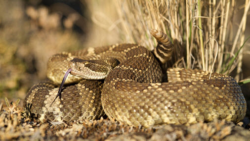
The Western Rattlesnake (Crotalus oreganus) is a large snake (up to 1.3 m long) with a triangular head, narrow neck, vertical pupil, and a tail that ends with a rattle or button. The background body colour is brown, olive, or grey. A series of large dark-brown blotches surrounded by light-coloured borders, or “halos,” run down the middle of the back, with smaller, similar blotches along the sides. A dark line runs between the eye and the jaw. Juveniles have a lighter background colour with more contrasting blotches on the back. Neonates (newborns) are ~285 mm long and have a “button” instead of a rattle. Western Rattlesnakes use fangs to inject chemicals that subdue prey and begin digestion. If threatened or harassed, rattlesnakes may use venom for defence, although unprovoked bites on humans are relatively uncommon and human deaths are extremely rare in British Columbia.
Western Rattlesnakes occur in the dry Southern Interior of the province within five geographic areas: Thompson-Nicola, Vernon, Okanagan-Similkameen, Midway, and Grand Forks. They are associated with relatively low-elevation (mostly < 1430 m) rock outcrops, talus, riparian, shrub–steppe, and open ponderosa pine and Interior Douglas-fir forest habitats. Their active season is from March to October.
The Western Rattlesnake was designated as Threatened by the Committee on the Status of Endangered Wildlife in Canada (COSEWIC) because of historic and ongoing habitat loss and mortality caused by vehicles and persecution. It is listed as Threatened in Canada on Schedule 1 of the Species at Risk Act. In British Columbia, the Western Rattlesnake is ranked “S3” (vulnerable) by the Conservation Data Centre and is on the provincial Blue List. The B.C. Conservation Framework ranks the Western Rattlesnake as a priority 2 under goal 2 (prevent species and ecosystems from becoming at risk). Under the provincial Wildlife Act, it is protected from capture and killing. It is also listed as a species that requires special management attention to address the impacts of forest and range activities under the Forest and Range Practices Act and the impacts of oil and gas activities under the Oil and Gas Activities Act on Crown land (as described in the Identified Wildlife Management Strategy). Recovery is considered biologically and technically feasible.
The overall province-wide threat impact for this species is High. This overall threat impact considers the cumulative impacts of multiple threats. Primary threats include direct harm from road mortality and persecution. Lower-ranked threats include habitat loss and fragmentation from housing and agricultural development, recreation, fire suppression, and potential diseases from invasive non-native/alien species.
The recovery goal is to maintain or increase the abundance of Western Rattlesnake in each of the five geographic areas in British Columbia and to maintain or increase connectivity within these areas.
The following objectives are necessary to meet the recovery goal and recover the species.
- Reduce persecution and road mortality to a level that will not affect population viability.
- Secure den (hibernation) sites and connected gestation, shedding, foraging/migration, and dispersal habitat throughout the species’ known range in British Columbia.
- Address knowledge gaps related to population demography, habitat quality, distribution and use, priority threats and effectiveness of recovery actions.
The recovery of Western Rattlesnake in British Columbia is considered technically and biologically feasible based on the following four criteria that Environment and Climate Change Canada uses to establish recovery feasibility.
i COSEWIC (Committee on the Status of Endangered Wildlife in Canada)
- FRPA:iiiSpecies at Risk
- OGAA:iii Species at Risk
- B.C. Wildlife Act:ivSchedule A
- SARA:vSchedule 1 –Threatened (2005)
- B.C. List: Blueii
- B.C. Rank: S3 (2012)
- National Rank: N3 (2015)
- Global Rank: G5 (2016)
- Other Subnational Ranks:vii Arizona (S5), California (SNR), Colorado (SNR), Idaho (S5), Navajo Nation (SNR), Nevada (S5), New Mexico (SNR), Oregon (S5), Utah (SNR), Washington (S5), Wyoming (S1)
ii Data source: B.C. Conservation Data Centre (2016), unless otherwise noted.
iii Species at Risk = a listed species that requires special management attention to address the impacts of forest and range activities on Crown land under the Forest and Range Practices Act (FRPA; Province of British Columbia 2002) and the impacts of oil and gas activities on Crown land under the Oil and Gas Activities Act (OGAA; Province of British Columbia 2008) as described in the Identified Wildlife Management Strategy (Province of British Columbia 2004).
iv Schedule A = designated as wildlife under the British Columbia Wildlife Act, which offers it protection from direct persecution and mortality (Province of British Columbia 1982).
v Schedule 1 = found on the List of Wildlife Species at Risk under the Species at Risk Act(SARA; Government of Canada 2002).
vi S = subnational; N = national; G = global; 1 = critically imperiled; 3 = special concern, vulnerable to extirpation or extinction; 5 = demonstrably widespread, abundant, and secure.
vii Data source: NatureServe (2016).
viii Data source: B.C. Ministry of Environment (2009).
ix Six-level scale: Priority 1 (highest priority) through to Priority 6 (lowest priority).
The Western Rattlesnake (Crotalus oreganus) is a large snake (up to 1.3 m long) with a triangular head, narrow neck, vertical pupil, and a tail that ends with a rattle or button (Figure 1) (Matsuda et al. 2006). The background body colour is brown, olive, or grey. A series of large dark-brown blotches surrounded by light-coloured borders, or “halos,” run down the middle of the back, with smaller, similar blotches along the sides. A dark line runs between the eye and the jaw (Matsuda et al. 2006). Juveniles have a lighter background colour with more contrasting blotches on the back (Matsuda et al. 2006). Neonates (newborns) are ~285 mm long (Charland in Kirk et al. 2016) and have a “button” instead of a rattle (Matsuda et al. 2006) until the first shedding of skin (moult). Western Rattlesnakes use fangs to inject chemicals that subdue prey and begin digestion (Matsuda et al. 2006). If threatened or harassed, rattlesnakes may use venom for defence, although unprovoked bites on humans are relatively uncommon and human deaths are extremely rare in British Columbia (COSEWIC 2015). They can be seen from March to October in the dry Southern Interior in the Bunchgrass, Ponderosa Pine, and Interior Douglas-fir biogeoclimatic zones (COSEWIC 2015). They are associated with rock outcrops, talus, riparian, shrub–steppe, and open forest habitats (COSEWIC 2015).
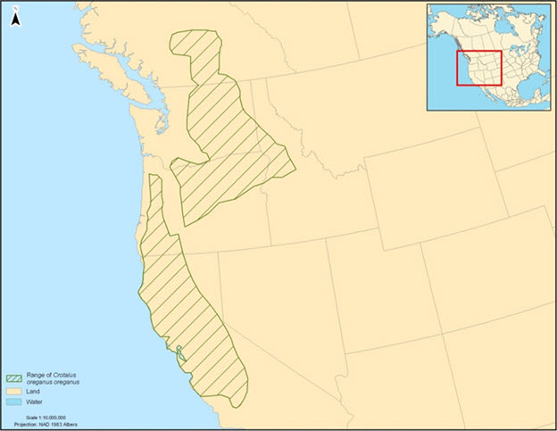
Globally, the Western Rattlesnake (all subspecies) occurs in western North America, from south-central British Columbia to California and New Mexico, and east to the Rocky Mountains (NatureServe 2016). Western Rattlesnake populations in southern British Columbia are the oreganus subspecies (C. oreganus oreganus), which occurs in Washington, Idaho, Oregon, and northern California (Figure 2). Canada has less than 5% of the global distribution of this species, based on distribution maps (Southern Interior Reptile and Amphibian Recovery Team 2008).
Long description for Figure 2
A map of western North America shows that the range of the Western Rattlesnake Crotalus oreganus oreganus is composed of two patches: one patch extends from the Pacific Coast of central California, northwards to Oregon. Another patch, is located east and north of the first patch, extending from central Oregon, northwards to south central British Columbia, the patch narrows as it extends north into British Columbia.
In British Columbia, the Western Rattlesnake is restricted to the Southern Interior of the province (Matsuda et al. 2006). It occurs in the Fraser, Thompson, Nicola, Okanagan, Lower Similkameen, and Kettle drainages within five geographic areas in Canada (Figure 3) (COSEWIC 2015): Thompson-Nicola, Vernon, Okanagan-Similkameen, Midway, and Grand Forks. The Okanagan-Similkameen area may be connected with Midway and Grand Forks through the United States, but this is unconfirmed. One other area, along the west bank of the Columbia River near Trail, may have been occupied; however, it is based on a single, historic record (Hobbs 2013) and is not confirmed. The Western Rattlesnake occurs in the dry hot Bunchgrass, Ponderosa Pine, and Interior Douglas-fir biogeoclimatic zones, mostly below 1430 m in elevation (COSEWIC 2015).
Long description for Figure 3
A map of the south central region of British Columbia shows habitat for the Western Rattlesnake located mainly in two river valley areas. In the northwest, a continuous patch occupies a section of the Thompson-Nicola river valley. Southeast of this, a there is a patch labeled Vernon, directly adjacent a lake to the west of this patch. Directly south of this, the distribution occupies the Okanagan-Similkameen river valley area. Two small and isolated patches exist east of this labeled as Midway and Grand Forks.
There are 368 known extant and 12 extirpated dens (hibernacula) in the province (Provincial Snake Den Database; Sarell and Hobbs, unpubl. data, 2013, in COSEWIC 2015). Although substantial inventory has been done (Table 1), den surveys are not complete and survey effort is biased toward Crown land. There are 244 known dens (66%) on provincial and federal Crown land, 66 (18%) on Indian Reserve land, and 58 (16%) on private land. Eighty-two known dens (22%) are protected on Crown and private conservation lands (e.g., Parks, Protected Areas, Ecological Reserves, Wildlife Management Areas, The Nature Trust, The Nature Conservancy).
| Tenure type | Grand Forks | Midway | Okanagan-Similkameen | Thompson-Nicola | Vernon | % of total dens |
|---|---|---|---|---|---|---|
| Crown Land | 10 | 8 | 63 | 68 | 6 | 42.1 |
| Crown Conservation Land | 0 | 0 | 39 | 10 | 15 | 17.4 |
| Federal Land | 0 | 0 | 24 | 0 | 1 | 6.8 |
| Indian Reserve | 0 | 0 | 62 | 4 | 0 | 17.9 |
| Private Land | 3 | 2 | 26 | 3 | 6 | 10.9 |
| Private Conservation Land | 0 | 1 | 17 | 0 | 0 | 4.9 |
| Total | 13 | 11 | 231 | 85 | 28 | 100 |
Population size is not known and the following estimates, very well summarized in COSEWIC (2015), have substantial variation. The B.C. Conservation Data Centre estimates 2500–10 000 individuals with 5000 adults based on NatureServe methods. Hobbs (2013) provided a minimum estimate of 3943–7896 individuals based on documented den counts, noting that not all dens are known and not all snakes are counted during single den visits.
A 10-year mark-recapture study of Western Rattlesnake at Osoyoos estimated there were 355 adults and juveniles on average at their study site (Kirk et al. 2016) in approximately 350 ha of habitat. Kirk et al. also developed provincial population estimates based on the Osoyoos data and habitat models. Their lowest estimate of 17 375 adults and juveniles (95% highest density interval range: 11 941–24 815) was considered the most realistic and defensible by the authors because it incorporated impacts from road and agriculture where habitat quality is lower and snakes suffer high mortality. The model also estimated an average of 8810 adults (breeding population). Kirk et al. (2016) created a second model, which did not consider road density and included agricultural habitat, that estimated an average of 31 535 adults and juveniles (95% highest density interval range: 21 673–45 037). This model version is almost double the estimate that considered roads and agricultural areas, quantifying their impact.
Although population trends are not well quantified, Western Rattlesnake numbers are presumed to be declining. This is a result of threats from road mortality and persecution by humans, and from habitat loss, degradation, and fragmentation related to housing and agricultural development (Hobbs and Sarell 2000; Hobbs 2001; Bertram et al. 2001; COSEWIC 2015). Hobbs (2013) estimated that over 75% of known dens have declining trends related to their proximity to these threats. COSEWIC (2015) reported that 12 dens (3% of total) are known to have been extirpated since the 1980s and suggested that a population decline of 30% over the next 45 years (three generations) is plausible, if threats continue at current rates.
The Western Rattlesnake occurs in the Bunchgrass, Ponderosa Pine, and Interior Douglas-fir biogeoclimatic zones found in the Southern Interior of British Columbia (COSEWIC 2015). Western Rattlesnakes are strongly associated with rock outcrops, talus slopes, shrub–steppe, grassland, riparian, and open ponderosa pine (Pinus ponderosa) and Rocky Mountain Douglas-fir (Pseudotsuga menziesii var. glauca) forest habitats (Macartney 1985; Bertram et al. 2001; Harvey 2015). These snakes can also occur in urban and agricultural areas (Didiuk et al. 2004) but suffer additional mortality in these habitats and appear to decline over time (Hobbs, pers. comm., 2016). Western Rattlesnakes require overwintering dens (hibernacula), gestation sites, shedding sites and summer foraging/migration habitats that are all connected within their home ranges.
Function: Denning (Hibernation)
Western Rattlesnakes move to den sites in September through October (Hobbs 2013) and hibernate communally from mid-October to late March, depending on the year (COSEWIC 2015), with egress from the den typically occurring by mid-April (Hobbs 2013). They often hibernate with other snake species (e.g., Gopher Snake [Pituophis catenifer deserticola], Threatened; North American Racer [Coluber constrictor], Threatened; and Desert Nightsnake [Hypsiglena chlorophaea], Endangered) (Macartney 1985; Sarell 1993; Hobbs and Sarell 2000, Hobbs 2001). Most (> 80%, N = 318) known dens in the province occur at 400–800 m elevation, with a maximum reported den elevation of approximately 1200 m (Hobbs 2013). Western Rattlesnake sightings have been reported from 152 m to 1430 m (Hobbs 2013). Known dens occur on southwest to southeast aspects (COSEWIC 2015). Slopes range from 0% to 90% (N = 52) in the south Okanagan (Sarell 1993). Bertram et al. (2001) reported aspects of 71.7°–168.3° near Kamloops, and Hobbs (2013) suggested aspects of 170°–240° are important. Sarell (1993) reported that 78% of south Okanagan dens were on south or southwest aspects, although one den was on a northeast aspect and two suspected dens were likely on northwest aspects. Thermal properties (i.e., warmth from sunlight) on these sunny aspects are important and shading by vegetation may limit the effectiveness of dens and basking sites (COSEWIC 2015). Dens typically are in cracks or fissures within cliffs or rock outcrops, talus slopes, or earth-covered rock outcrops that provide access below the frost line (COSEWIC 2015). Suitable den sites also require cover (rocks and vegetation), for security from predators, and basking sites (typically south aspect rock surfaces), for thermoregulation in spring and fall, close to the den entrance (Gienger and Beck 2011; Hobbs 2013). Dens must have stable internal subterranean temperatures to allow snakes to avoid sub-zero conditions (COSEWIC 2015). Macartney (1985) reported one den that ranged between 3°C to 5°C and was 1.3 m below ground. Hobbs (2007) reported an average body temperature of 6.4°C for 15 snakes, average den temperature of 9.6°C, and calculated that depths of 0.86–3.00 m below ground could meet thermal requirements. Humidity may also be important but research is lacking (Hobbs 2013). Western Rattlesnakes have considerable den site fidelity, mostly returning to the same den each year (Macartney 1985), and den use may continue for hundreds of years (COSEWIC 2015).
Tables 2 and 3 present a summary of functions, features, and attributes for Western Rattlesnake denning habitat.
| Life stage(s) | Functiona | Feature(s)b |
|---|---|---|
| All | Overwintering | Dens (hibernacula) |
a Function: a life-cycle process of the species (e.g., overwintering).
b Feature: the essential structural components of the habitat required by the species.
| Attributec | Description |
|---|---|
| Elevation | Up to about 1200 m elevation but most are < 800 m in elevation |
| Climate | Dry, hot, Bunchgrass, Ponderosa Pine, Interior Douglas-fir biogeoclimatic zones in the southern interior of British Columbia |
| Availability | September through March |
| Aspect | Southwest to southeast aspects for basking but may occasionally be found on north aspects |
| Structure | Cliff, talus, or earth-covered rock outcrop with cracks or fissures that provide access below the frost line and rock outcrops for cover and basking |
| Temperature | Stable temperature approximately 3–9°C throughout hibernation season |
| Humidity | Suitable humidity to prevent desiccation is likely important but details are unknown |
| Other | Limited vegetative cover that may create shade, which limits basking opportunities |
c Attribute: the building blocks or measurable characteristics of a feature.
Function: Foraging, Migration, Mating, Shedding, Basking
The area of foraging habitat around a den overlaps with several other habitat types used for migration, mating, shedding, and basking.
Western Rattlesnake migration routes vary depending on den location and summer foraging strategies. Many Western Rattlesnakes near Vernon moved upslope to ridgetops before dispersing in all directions, although some also moved downslope (Macartney 1985). Snakes at some dens followed specific routes toward ridgetops (Macartney 1985). Harvey (2015) found two broad types of migration routes. Some snakes moved toward grasslands, generally downslope from dens, and others moved toward forested habitats, generally upslope of dens along thermally warmer corridors.
Mating habitat also overlaps with foraging habitat and is used between July and early August in British Columbia (Macartney 1985; Snook and Blaine 2012). Aldredge (2002) reported two types of mating strategies for Western Rattlesnake. One strategy was to mate in summer, resulting in immediate fertilization. The second strategy was to mate in fall, then store sperm over the winter, using it to fertilize eggs in spring, shortly after emergence.
Snakes retreat to cover objects about 1 week before shedding because vision is impaired by an exudate between the old and new skin, making them more vulnerable to predators (Klauber 1997). Western Rattlesnakes mainly use rock outcrops, talus, and crevices within their home ranges during the summer to shed their skins before resuming foraging (Macartney 1985). Some snakes shed at sites with other cover objects (e.g., shrubs, concrete structures) (Maida, pers. comm., 2016). Some sites are communal and re-used annually (Macartney 1985). For example, 10 of 14 males and 4 of 5 females re-used shedding sites in consecutive years in Vernon (Macartney 1985). Other sites may be used only once or irregularly (Maida, pers. comm., 2016).
The Western Rattlesnake makes seasonal movements in March and April from winter dens to summer foraging habitat. Most feeding occurs from June to August and little feeding occurs in spring and fall (Macartney 1985). Gravid females seldom feed before or after parturition (Macartney 1989). Foraging and migration habitat is shrub–steppe, grasslands, open ponderosa pine and Douglas-fir forest, and riparian areas (Macartney 1985; Bertram et al. 2001; Lomas 2013; Gomez et al. 2015) up to 1430 m elevation (Hobbs 2013; COSEWIC 2015). Urban and agricultural habitats can also be used for foraging (Southern Interior Reptile and Amphibian Recovery Team 2008), but these sites often expose snakes to higher levels of mortality. Within the above broad habitat types, cover objects are important for thermal regulation and security habitat: rock outcrops, large rocks, rock piles, talus, bluffs, live and dead shrubs, fallen trees, coarse woody debris, rodent burrows, concrete berms, and plywood (COSEWIC 2015).
Basking (exposure to the sun to increase temperature) is important for Western Rattlesnakes, which are ectotherms, and may take up to an average of 25% (in forest habitat) to 42% (in open habitat) of daily activity time (Harvey 2015). Basking can occur in various habitats that have exposure to sunlight. Thermal regulation to increase temperature may also be achieved through warm substrates (Lomas 2013), which can include natural habitats such as rocks or human-created habitats such as roads.
Foraging habitat must support suitable numbers of prey species. The Western Rattlesnake preys mainly on small mammals: North American Deermouse (Peromyscus maniculatus), Great Basin Pocket Mouse (Perognathus parvus), voles (Microtus, Myodes, Phenacomys sp.), shrews (Sorex sp.), Northern Pocket Gopher (Thomomys talpoides), and Bushy-tailed Woodrat (Neotoma cinerea) (COSEWIC 2015). They also prey on birds and other snakes (COSEWIC 2015). Macartney (1989) sampled stomach contents of 221 Western Rattlesnakes from the Vernon area and documented 9 species of rodents (91% of diet), shrews (5%), and birds (4%). Maida (2014) analyzed 50 road-killed Western Rattlesnakes from the South Okanagan, finding 26 (52%) with stomach contents. He found 9 different identifiable prey species including rodents (72%), shrews (21%), and birds (7%) (N = 29). Prey species included North American Deer Mouse (41%), shrews (21%), Western Harvest Mouse (Reithrodontomys megalotis; 7%), Great Basin Pocket Mouse (7%), Yellow-bellied Marmot (Marmota flaviventris; 7%), birds (7%), Columbian Ground Squirrel (Urocitellus columbianus; 3%), voles (3%), and Red Squirrel (Tamiasciurus hudsonicus; 3%). Juveniles (< 650 mm snout to vent length) ate North American Deer Mouse almost exclusively (10/13, 77%) and shrews. Merko (2013) found muskrat, voles, North American Deer Mouse, and Great Basin Pocket Mouse in 13 Western Rattlesnake fecal samples near Osoyoos.
Seasonal maximum movement distances from dens to foraging sites in the province range from 290 m to 3568 m (COSEWIC 2015) and up to 3986 m (Harvey 2015). Gravid females remain within 300 m of dens until parturition in September or October (Macartney 1985; Betram et al. 2001). Average maximum distances for non-gravid females and males ranged from 0.62 km to almost 3 km in six studies:
- 1.2 km (Macartney 1985);
- 1.2 km (Bertram et al. 2001);
- 1.3 km (random movement) and 3.0 km (directed movement) (Gomez 2007);
- 0.62 km (within 50–100 m of disturbed habitat) and 1.042 km (> 200 m to disturbed habitat), 2.7 km (“mountain snakes” that moved to higher elevations in forest habitat) (Lomas 2013);
- 0.97 km (grassland) and 2.9 km (forest) (Gomez et al. 2015); and
- 1.847 km (Harvey 2015).
Average maximum straight-line distance movements from dens were significantly longer for snakes using forest habitat (2.359 km) compared to snakes using open (1.337 km) habitats (Harvey 2015).
Home range size for Western Rattlesnakes in the province varies from 0.12 ha for a gravid female (Bertam et al. 2001) to 194.7 ha (Harvey 2015). Lomas (2013) calculated an average home range of 20 ha at Osoyoos using a minimum convex polygon. Harvey (2015) reported a mean home range size of 52 ha from 30 snakes in the Thompson-Nicola and Okanagan-Similkameen areas with a range of 1.5–194.7 ha. Forest snakes had larger average home ranges (69.3 ha) compared to open habitat snakes (35.0 ha). Forest snakes used warmer areas of the landscape and had better body condition and weight gain (Harvey 2015). Research by Gomez et al. (2015) and Harvey (2015) have clearly demonstrated the value of forest habitats, in terms of use and improved body condition, to Western Rattlesnake. Individual Western Rattlesnakes have a high fidelity to foraging sites (Brown et al. 2009).
Tables 4 and 5 present a summary of functions, features, and attributes for foraging/migration habitat.
| Life stage(s) | Functiond | Feature(s)e |
|---|---|---|
| All | Foraging, migration, mating, shedding, basking | Grassland, shrub–steppe, riparian, open ponderosa pine or Douglas-fir forest |
d Function: a life-cycle process of the species (e.g., foraging, migration, mating).
e Feature: the essential structural components of the habitat required by the species.
| Attributef | Description |
|---|---|
| Elevation | Up to about 1430 m elevation |
| Climate | Dry, hot, Bunchgrass, Ponderosa Pine, Interior Douglas-fir biogeoclimatic zones in the southern interior of British Columbia |
| Habitat types | Cliff, talus, rock outcrop, grassland, shrub–steppe, riparian, wetland, open ponderosa pine and Rocky Mountain Douglas-fir forest; agricultural and urban habitats may be used but mortality is increased |
| Availability | March through October |
| Retreats | Rock outcrops, large rocks, rock piles, talus, bluffs, live and dead shrubs, grass and forbs, live and dead trees (for shade and cover), fallen trees, coarse woody debris, rodent burrows, and some concrete structures; basking often takes place in sunny areas near retreats and at hibernacula |
| Shedding retreats | Rock outcrops, large rocks, rock piles, talus, and concrete berms where communal shedding occurs, often over more than 1 year |
| Distance from den | Highly variable between open and forest habitats but averages are mostly within ~ 2.8 km. The maximum straight line distance for a single snake is about 4 km. |
| Prey | Various small mammals (rodents and shrews), birds, and snakes |
| Other | Low densities of housing, agriculture, roads and vehicle traffic, all of which increase potential for direct mortality and may cause barriers to movement |
f Attribute: the building blocks or measurable characteristics of a feature.
Function: Incubation
The Western Rattlesnake is ovoviviparous, meaning eggs are incubated and hatch within a female’s body and young are born alive. Macartney (1985) found rookeries (areas where gravid snakes congregate) in the North Okanagan were very near (< 8 m) the den entrance or at “medium to large table rocks (large flat rocks) or rockpiles < 50 m from most dens.” Rookeries are used for gestation by pregnant females from April until parturition (birth) occurs in September or October (Macartney 1985). Females seldom feed during that time and depend on fat reserves (Macartney and Gregory 1988); however, some females disperse up to 660 m in spring or summer, presumably to forage, before returning to rookeries near the den until parturition (Maida, pers. comm., 2016). Birth took place mostly at the hibernacula but some were observed at basking rocks within 30 m of a den (Macartney and Gregory 1988). Gestation sites are exposed to direct sunlight, which may allow gravid females to maintain optimal body temperatures for growth of the young, and ensure ready access to cover objects for security habitat. Most females (74%) reproduce young once every 3 years or longer, although some (26%) reproduce every 2 years, likely depending on recovery of body weight (Macartney and Gregory 1988). They have an average of 4.6 (range: 2–8) young per litter (Macartney and Gregory 1988).
Tables 6 and 7 present a summary of functions, features, and attributes for gestation habitat.
| Life stage(s) | Functiong | Feature(s)h |
|---|---|---|
| Pregnant adult females | Gestation | Rookeries |
g Function: a life-cycle process of the species (e.g., overwintering).
h Feature: the essential structural components of the habitat required by the species.
| Attributei | Description |
|---|---|
| Elevation | Up to about 1200 m elevation |
| Climate | Bunchgrass, Ponderosa Pine, Interior Douglas-fir biogeoclimatic zones in the southern interior of British Columbia |
| Availability | April through October |
| Aspect | Generally southwest to southeast aspects but may be found on all other aspects |
| Structure | Cover objects such as cliff, talus, rock outcrop, rock piles, or large rocks |
| Distance from den | Mostly within 50 m of a den site |
| Other | Limited vegetative cover that may create shade |
i Attribute: the building blocks or measurable characteristics of a feature.
Function: Dispersal
Longer movements, outside of the species’ normal home range, may occur across additional terrestrial habitat, allowing for colonization of new sites and/or between local sites. These occasional movements are not part of regular seasonal habitat use but are considered dispersal movements, and the additional terrestrial habitat required to meet this species’ need is termed “connectivity” habitat. Connectivity habitat is essential to support gene flow and long-term persistence of viable populations of snakes within the landscape. Populations that are isolated and have limited genetic diversity can be more susceptible to disease and increased mortality related to inbreeding depression (Clark et al. 2011). For example, Clark et al. (2011) documented that loss of connectivity resulted in genetic isolation, which contributed to physical abnormalities and disease, likely related to inbreeding depression, in a small population of Timber Rattlesnake (Crotalus horridus) in New Hampshire. Clark et al. (2010) stated “roads are extremely effective barriers to gene flow” in Timber Rattlesnakes, despite the relatively short time period that paved, high-speed roads have existed. Although roads may not necessarily be barriers to movement, they are barriers to gene flow owing to direct mortality from vehicles. Maintaining this connectivity, for both movement and gene flow, is important to ensure long-term population viability. Very little is known about long-distance dispersal in British Columbia. The longest recorded movement in the province is about 4 km within a home range (Harvey 2015), so dispersal distances likely can be greater than 4 km. NatureServe uses 5 km in suitable habitat as a separation distance between populations and 1 km in unsuitable habitat (Hammerson 2005). Research on this topic is needed. It is assumed that dispersal/connectivity habitat is similar to foraging habitat (see Section 3.3.2).
Tables 8 and 9 present a summary of functions, features, and attributes for dispersal/connectivity habitat.
| Life stage(s) | Functionj | Feature(s)k |
|---|---|---|
| All | Dispersal | Grassland, shrub–steppe, riparian, open ponderosa pine or Douglas-fir forest |
j Function: a life-cycle process of the species (e.g., dispersal between locations populations and subpopulations).
k Feature: the essential structural components of the habitat required by the species.
| Attributel | Description |
|---|---|
| Elevation | Up to about 1430 m elevation |
| Climate | Dry, hot, Bunchgrass, Ponderosa Pine, Interior Douglas-fir biogeoclimatic zones in the southern interior of British Columbia |
| Habitat types | Cliff, talus, rock outcrop, grassland, shrub–steppe, riparian, wetland, open ponderosa pine and Rocky Mountain Douglas-fir forest; agricultural and urban habitats may be used but mortality is increased |
| Availability | April through October |
| Structure | Rock outcrops, large rocks, rock piles, talus, bluffs, live and dead shrubs, fallen trees, coarse woody debris, rodent burrows, and some concrete structures |
| Shedding structure | Rock outcrops, large rocks, rock piles, talus, concrete berms where communal shedding occurs, often over more than 1 year |
| Distance from den | Maximum dispersal distance unknown, but likely can be greater than 4–5 km in suitable habitat |
| Prey | Various small mammals (rodents and shrews), birds, and snakes |
| Other | Low densities of housing, agriculture, roads and vehicle traffic, all of which increase potential for direct mortality, and related gene flow, and may cause barriers to movement |
l Attribute: the building blocks or measurable characteristics of a feature.
The Western Rattlesnake plays an integral role in the food chain in grassland and open, dry forest ecosystems, as predator and prey. As a specialized small mammal predator (Matsuda et al. 2006), Western Rattlesnakes may play an important role in keeping rodent populations under control. As predators in their ecosystem, they also eat birds and other snakes. As a prey species themselves, Western Rattlesnakes are likely important food for raptors (e.g., Red-tailed Hawk [Buteo jamaicensis]) (Harvey 2015), as well as American Badger (Taxidea taxus), American Black Bear (Ursus americanus), Striped Skunk (Mephitis mephitis), and Coyote (Canis latrans) (Didiuk et al. 2004).
Limiting factors are generally not human-induced and include characteristics that make the species less likely to respond to recovery/conservation efforts (e.g., inbreeding depression, long-lived species with low rate of reproduction, genetic isolation). Recovery of Western Rattlesnake populations is limited by several natural factors. They require specialized winter dens that are limited on the landscape. Large numbers of Western Rattlesnakes aggregate at winter den sites in the spring and fall, making them vulnerable to catastrophic events. Their high fidelity to den sites limits recolonization of extirpated sites or expansion into new habitats (COSEWIC 2015). They have delayed sexual maturity (7–9 years in females), a low reproductive rate (2–8 young per female), infrequent parturition (every 3–4 years), and low young survivorship (Macartney 1985; Macartney et al. 1987; COSEWIC 2015). Lomas et al. (2015) showed that some Western Rattlesnakes had continued use of disturbed areas over numerous active seasons and “snakes in the most disturbed areas (< 10 m to the nearest source of human activity or development) had lower weights and body condition, and they lost significantly more weight during the active season.” This suggests that Western Rattlesnakes may not possess the behavioural plasticity needed to avoid altered or disturbed habitat.
Threats are defined as the proximate activities or processes that have caused, are causing, or may cause in the future the destruction, degradation, and/or impairment of the entity being assessed (population, species, community, or ecosystem) in the area of interest (global, national, or subnational) (adapted from Salafsky et al. 2008). For purposes of threat assessment, only present and future threats are considered.Footnote1 Threats presented here do not include limiting factors, which are presented in Section 3.5.Footnote2
For the most part, threats are related to human activities, but they can also be natural. The impact of human activity may be direct (e.g., destruction of habitat) or indirect (e.g., invasive species introduction). Effects of natural phenomena (e.g., fire, hurricane, flooding) may be especially important when the species or ecosystem is concentrated in one location or has few occurrences, which may be a result of human activity (Master et al. 2012). As such, natural phenomena are included in the definition of a threat, though they should be considered cautiously. These stochastic events should only be considered a threat if a species or habitat is damaged from other threats and has lost its its ability to recover. In such cases, the effect on the population would be disproportionately large compared to the effect experienced historically (Salafsky et al. 2008).
The threat classification below is based on the IUCN–CMP (World Conservation Union–Conservation Measures Partnership) unified threats classification system and is consistent with methods used by the B.C. Conservation Data Centre. For a detailed description of the threat classification system, see the Open Standards website (Open Standards 2014). Threats may be observed, inferred, or projected to occur in the near term. Threats are characterized here in terms of scope, severity, and timing. Threat “impact” is calculated from scope and severity. For information on how the values are assigned, see Master et al. [PDF, 1.6 Mb] (2012) and table footnotes for details. Threats for the Western Rattlesnake were assessed for the entire province and apply to all geographic areas (Table 10) (COSEWIC 2015).
| Threat #m | Threat description | Impactn | Scopeo | Severityp | Timingq |
|---|---|---|---|---|---|
| 1 | Residential and commercial development | Low | Small | Serious | High |
| 1.1 | Housing and urban areas | Low | Small | Serious | High |
| 1.2 | Commercial and industrial areas | Negligible | Negligible | Extreme | High |
| 1.3 | Tourism and recreation areas | Negligible | Negligible | Moderate | High |
| 2 | Agriculture and aquaculture | Low | Pervasive | Slight | High |
| 2.1 | Annual and perennial non-timber crops | Low | Small | Serious | High |
| 2.3 | Livestock farming and ranching | Low | Pervasive | Slight | High |
| 3 | Energy production and mining | Negligible | Negligible | Extreme | High |
| 3.2 | Mining and quarrying | Negligible | Negligible | Extreme | High |
| 4 | Transportation and service corridors | High | Pervasive | Serious | High |
| 4.1 | Roads and railroads | High | Pervasive | Serious | High |
| 4.2 | Utility and service lines | Negligible | Negligible | Slight | High |
| 5 | Biological resource use | Medium–Low | Pervasive | Moderate–Slight | High |
| 5.1 | Hunting and collecting terrestrial animals | Medium–Low | Pervasive | Moderate–Slight | High |
| 5.3 | Logging and wood harvesting | Unknown | Small | Unknown | High |
| 6 | Human intrusions and disturbance | Low | Pervasive | Slight | High |
| 6.1 | Recreational activities | Low | Pervasive | Slight | High |
| 6.2 | War, civil unrest, and military exercises | Negligible | Negligible | Negligible | High |
| 7 | Natural system modifications | Low | Pervasive | Slight | High |
| 7.1 | Fire and fire suppression | Low | Pervasive | Slight | High |
| 8 | Invasive and other problematic species and genes | Low | Restricted | Slight | High |
| 8.1 | Invasive non-native/alien species | Low | Restricted | Slight | High |
| 8.2 | Problematic native species | Unknown | Restricted | Unknown | High |
| 9 | Pollution | Unknown | Restricted–Small | Unknown | High |
| 9.3 | Agricultural and forestry effluents | Unknown | Restricted–Small | Unknown | High |
| 10 | Geological events | Negligible | Negligible | Extreme | High |
| 10.3 | Avalanches/landslides | Negligible | Negligible | Extreme | High |
| 11 | Climate change and severe weather | Unknown | Pervasive | Unknown | High |
m Threat numbers are provided for Level 1 threats (i.e., whole numbers) and Level 2 threats (i.e., numbers with decimals).
n Impact – The degree to which a species is observed, inferred, or suspected to be directly or indirectly threatened in the area of interest. The impact of each threat is based on severity and scope rating and considers only present and future threats. Threat impact reflects a reduction of a species population. The median rate of population reduction for each combination of scope and severity corresponds to the following classes of threat impact: Very High (75%), High (40%), Medium (15%), and Low (3%). Unknown: used when impact cannot be determined (e.g., if values for either scope or severity are unknown); Not Calculated: impact not calculated as threat is outside the assessment time (e.g., timing is insignificant/negligible [past threat] or low [possible threat in long term]); Negligible: when scope or severity is negligible; Not a Threat: when severity is scored as neutral or potential benefit.
o Scope – Proportion of the species that can reasonably be expected to be affected by the threat within 10 years. Usually measured as a proportion of the species’ population in the area of interest. (Pervasive = 71–100%; Large = 31–70%; Restricted = 11–30%; Small = 1–10%; Negligible < 1%).
p Severity – Within the scope, the level of damage to the species from the threat that can reasonably be expected to be affected by the threat within a 10-year or 3-generation time frame. For this species, a generation time of 15 years (COSEWIC 2015) was used, resulting in severity being scored over a 45-year time frame. Severity is usually measured as the degree of reduction of the species’ population. (Extreme = 71–100%; Serious = 31–70%; Moderate = 11–30%; Slight = 1–10%; Negligible < 1%; Neutral or Potential Benefit ≥ 0%).
q Timing – High = continuing; Moderate = only in the future (could happen in the short term [< 10 years or 3 generations]) or now suspended (could come back in the short term); Low = only in the future (could happen in the long term) or now suspended (could come back in the long term); Insignificant/Negligible = only in the past and unlikely to return, or no direct effect but limiting.
The overall province-wide Threat Impact for this species is High.Footnote3 This overall threat considers the cumulative impacts of multiple threats. Primary threats include direct harm from road mortality and persecution. Lower-ranked threats include habitat loss and fragmentation from housing and agricultural development, recreation, fire suppression, and potential diseases from invasive non-native/alien species (Table 10). Details are discussed below under the Threat Level 1 headings and apply to all areas.
Most Western Rattlesnake dens (< 800m elevation), gestation, foraging, and dispersal habitats (mostly < 1430 m) occur at low elevations where most urban development also occurs, creating a competition for habitat (Hobbs 2013). Housing and urban area footprints contribute to habitat loss and fragmentation of foraging habitat and, to a lesser degree, destruction of dens (COSEWIC 2015). Despite the relatively small area of impact, den destruction can eliminate entire local populations (COSEWIC 2015). Additional threats stem from direct mortality during development, potential isolation of remaining populations, and increased mortality from direct persecution and road traffic (COSEWIC 2015). Snake mortality from becoming trapped in plastic mesh used during construction, commercial orchard/vineyard operations, and in urban gardens is an emerging issue (Bishop, pers. comm., 2016). Lomas (2013) reported lower body condition and increased weight loss during the foraging season in Western Rattlesnakes using disturbed habitat (e.g., campground, resort, trail, and road) at Osoyoos, compared to undisturbed habitat. Lomas et al. (2015) suggested that indirect disturbance, as opposed to direct habitat loss, may affect survival, recruitment, and population stability. Direct persecution also occurs, although programs such as “Snake Smart” have reduced impacts at some sites (Okanagan Similkameen Conservation Alliance 2016). The authors also indicated that population persistence, in this relatively long-lived species, may mask serious population declines, which are difficult to detect until population collapse is imminent. Impacts related to urban development are likely most severe in the Okanagan Valley and Kamloops areas where new development continues at a rapid rate (COSEWIC 2015).
Development of natural habitat for commercial and industrial areas, and tourism and recreation areas, have Extreme and Moderate severity, respectively, but are expected to have a Negligible scope and impact in the next 10 years.
Most agricultural development occurs at low elevations where snake denning, foraging, and connectivity habitat also occurs (Hobbs 2013). Direct impacts on habitat are more likely to affect foraging sites rather than den sites because of the rocky characteristics of dens (i.e., by nature, they are less suitable for cultivation). Intensive agriculture reduces habitat suitability by clearing debris and top soil, and sometimes subsoil through contouring, removing cover objects and rodent burrows, and affecting prey availability (COSEWIC 2015). In addition to habitat alteration, agricultural crops disrupt movement corridors and cause accidental mortality with farm machinery (Bertrand et al. 2001). Mortality related to entrapment in small-diameter plastic mesh, used to protect crops from birds and also in bank stabilization, appears to be an increasingly serious issue (Bishop, pers. comm., 2016). Direct persecution also occurs, although programs such as “Snake Smart” have reduced impacts at some sites (Okanagan Similkameen Conservation Alliance 2016) (also see Threat 5). Poisoning of rodents using strychnine has been common in Okanagan orchards and vineyards (Bishop et al. 2016) (also see Threat 5). Several other types of rodenticide are also used in the province (Health Canada 2013). Agricultural impacts are greater in the southern Okanagan Valley where vineyards and orchards are prevalent and expanding, but impacts are increasing in all parts of the species’ range: Central Okanagan, Kettle, Similkameen, and Nicola (COSEWIC 2015).
Ranching occurs throughout the species’ range. The severity of impacts from grazing has not been studied well and evidence is limited (COSEWIC 2015). Intensive grazing by livestock can reduce cover for snakes and their small mammal prey (Bock et al. 1984; Hobbs and Sarell 2000; Ovaska and Sopuck 2004; Rickel 2005; Forest Practices Board 2007), which may increase predation on snakes and affect prey abundance (COSEWIC 2015) or foraging success. Jenkins et al. (2009) documented smaller size and lower reproductive output in a population of Western Rattlesnake in Idaho, compared to two other sites, and suggested the difference may be related to higher disturbance from grazing.
Mining may cause habitat loss to denning and foraging habits and increase direct mortality from vehicles during construction, blasting, excavation, and the moving and transport of materials. Locally, the severity of impacts can be Extreme, but the scope of overlap with Western Rattlesnake habitat is thought to be Negligible in the near future (COSEWIC 2015). Few renewable energy developments are expected to occur within the range of the Western Rattlesnake in the near future.
Transportation is the highest impact threat to the Western Rattlesnake in the province (COSEWIC 2015). Road construction causes direct loss of habitat and can cause direct mortality of snakes in the construction zone (COSEWIC 2015). In addition, Western Rattlesnakes are vulnerable to ongoing vehicle-caused mortality owing to their attraction to warm, paved surfaces for basking and their seasonal migratory movements between hibernacula and summer foraging areas. Some drivers admit to intentionally hitting snakes on roads (Hobbs, pers. comm., 2013; Sarell, pers. comm., 2013); in Ontario, 2.7 % of drivers intentionally hit herpetofauna (Ashley et al. 2007). Rattlesnakes may be more vulnerable to roads than other snakes because they may cross roads more slowly, may stop on the road and coil in a defensive stance, or freeze as a defensive mechanism, if a vehicle approaches (Fortney et al. 2012). Ongoing vehicle-caused mortality in proximity to den sites is associated with declining populations, population fragmentation, and expected extirpation of some subpopulations over time (COSEWIC 2015).
Road mortality occurs throughout the range of the Western Rattlesnake in the province (Okanagan: Picard 2009, Davis and Wise 2010, Snook and Blaine 2012; Kettle: Coleshill 2014; Thompson-Nicola: Bertram et al. 2001). Hobbs (2013) found 176 of 318 (49%) known Western Rattlesnake dens are within 1 km, and 274 dens (86%) are within 2 km of a paved road, demonstrating that most of the population in the province is at risk.
Snook and Blaine (2012) reported road kill as the highest source of mortality at their ~350 ha Osoyoos study site. Between 4% and 6% of their marked Western Rattlesnakes were killed on roads annually between 2010 and 2012.
Road impacts vary with type of road, traffic volume, and distance from dens. Fortney et al. (2012) reported snake, including Prairie Rattlesnake (Crotalus viridis), mortality rates on paved roads (18/36, 50%), gravel roads (16/36, 44%), and trails (2/36, 6%) in Saskatchewan but found higher numbers of live snakes on gravel roads (13/18). Snakes selected paved road significantly more than expected and twice as many dead snakes were found on paved roads than expected, based on paved road availability in the study area. Distance to den was a key factor in predicting road mortality, although the authors also suggested that threats increased with traffic volumes and were not simply dependent on road types.
Population modelling suggests catastrophic consequences of ongoing, low-level mortality from road kill. Row et al. (2007) estimated that road mortality of nine Black Ratsnakes (Elaphe obsoleta) per year increased extinction probability in their study population from 7.3% to 99% over 500 years. Road mortality of more than three adult females per year increased the extinction probability to more than 90%. Rudolph et al. (1999) suggested road mortality is the primary cause of local extinction for Timber Rattlesnakes (Crotalus horridus) in eastern Texas. The authors also reported that populations within 450 m of a road could be reduced by more than 50%, with population reductions continuing up to 850 m even on moderately traveled roads. Clark et al. (2010) stated “roads are extremely effective barriers to gene flow” in Timber Rattlesnakes, despite the relatively short time period that paved, high-speed roads have existed. In British Columbia, Western Rattlesnake and Gopher Snake (Pituophis catenifer) overlap in habitat, have similar biology, and experience similar threats, so may have a similar population response to road mortality. Reed (2013) predicted a population reduction of 40–50% in Gopher Snake, if road mortality affected adults only, and up to 90%, if road mortality affected all age classes over 24 years (three generations).
Kirk et al. (2016) modeled the provincial population size of the Western Rattlesnake, considering the impacts of roads and agriculture in one version and not considering these threats in a second version. The estimate of adults and juveniles, considering agriculture and road impacts, averaged 17 375 adults and juveniles. If agriculture and road impacts did not exist, the average population was estimated at 31 535. This model did not separate population impacts from roads only, but provides a scale of the impact from combined threats from roads and agriculture.
Utility and service lines also cause habitat loss and ongoing mortality, but the impact on the Western Rattlesnake is thought to be Negligible over the next 10 years.
The threat severity is not well documented for hunting and collecting Western Rattlesnake, thus the impact is estimated to range from Medium to Low. Persecution of the Western Rattlesnake is pervasive throughout its range in British Columbia (Bertram et al. 2001; Coleshill 2014; COSEWIC 2015). Illegal killing occurs for various reasons, including ignorance, fear/safety, cultural beliefs, and vandalism. The Western Rattlesnake has been intentionally killed in residential, recreational (e.g., golf courses), and agricultural areas despite Wildlife Act prohibitions (Dyer, pers. comm., 2016). Aggregations of Western Rattlesnakes at hibernacula and surrounding sites are particularly vulnerable to persecution and anthropogenic disturbance (Hobbs 2001; Gregory 2007). Western Rattlesnakes are occasionally illegally collected from the wild and kept as pets (Lomas, pers. comm., 2014), but impacts from this threat are thought to be Negligible compared to direct persecution.
Low-elevation logging and wood harvesting may cause accidental mortality during access road construction and harvesting or hauling of timber; however, the scope is likely Small and severity has not been researched, so the impact is Unknown.
Recreation activities occur throughout the range and may impact the Western Rattlesnake through direct mortality and behaviour change. Direct mortality has been documented in relation to hiking, camping, rock climbing, off-road vehicles, and mountain bikes, but the severity of the impact is thought to be Slight. Human disturbance (e.g., roads, trails, camp sites) in Killbear Provincial Park, Ontario, caused Eastern Massasauga Rattlesnakes to move less than snakes in undisturbed areas but did not appear to affect condition or growth rate (Parent and Weatherhead 2000). In the South Okanagan, a long-term mark-recapture data set revealed that Western Rattlesnakes residing in highly human-disturbed habitat lost weight over the foraging season and had lower body condition compared to other snakes in other areas, despite no major differences in behaviour or spatial ecology (Lomas et al. 2015). The threat from war, civil unrest, and military exercises is Negligible.
Fire suppression occurs throughout the range and may increase tree and shrub density, causing shading of basking sites or dens, which makes these sites less suitable (COSEWIC 2015). Fuel build up over time as a result of fire suppression can potentially lead to hot-burning and catastrophic wildfires. Although Western Rattlesnakes can avoid light burns by using underground burrows and interstitial spaces in rock and talus slopes, very hot, fast-burning fires may be inescapable, causing mortality. Fires may also remove cover objects, such as shrubs and coarse woody debris, making habitats temporarily less suitable (COSEWIC 2015). Fireguards constructed during active fire suppression can cause accidental mortality and destroy habitat. Impacts from fire and fire suppression are not well known and require research. The severity currently is believed to be Slight.
Cats and dogs occasionally kill Western Rattlesnakes (Klauber 1997), but Western Rattlesnake mortality caused by pets is likely low. Although invasive plant species occur throughout the range, impacts to Western Rattlesnakes have not been studied and impacts on prey species are not clear. Ophidiomyces ophiodiicola is an emerging fungal disease that only affects snakes and has been detected in eastern United States (Allender et al. 2015). This disease causes “widespread morbidity and mortality across the eastern United States” (Allender et al. 2015). Puncture vine (Tribulus terrestris) and longspine sandbur (Cenchrus longispinus) are invasive plants that are expanding their range in Western Rattlesnake habitat. No research is currently available, but these weeds may affect habitat use by snakes (Sarell, pers. comm., 2016). Raccoon (Procyon lotor) and Common Raven (Corvus corax) are native species that eat Western Rattlesnakes and have expanded their ranges and numbers in the province (Hatler et al. 2008; Environment Canada 2014), but their impact, if any, on the Western Rattlesnake is unknown.
Strychnine is used for rodent control, mostly for Northern Pocket Gopher (Thomomys talpoides), in vineyards and orchards in the dry interior of the province (COSEWIC 2015). A large amount (average:13 338kg/year) of strychnine-based rodenticide was sold in this area between 1991 and 2002 (Vakenti, pers. comm., 2006). No recent figures were available but use of strychnine may have temporarily declined owing to reduced product availability (Hollinger, pers. comm., 2016). No snake deaths related to secondary poisoning from rodenticide have been confirmed, although no research has been done on the topic (COSEWIC 2015). Bishop et al. (2016) modeled the risk of Gopher Snake poisoning by strychnine bait in the Okanagan and suggested it could have a substantial impact. The threat to the Western Rattlesnake may be less severe than for Gopher Snakes because of its sit-and-wait predatory behaviour and apparently low prey rate on Northern Pocket Gopher (Maida 2014); nevertheless, this threat should be studied to clarify the issue. Notably, the only documented case of possible snake poisoning by strychnine rodenticide was a prairie rattlesnake collected from New Mexico in which strychnine grain bait was used the previous day in burrow-baiting for rodent control (Campbell 1982). The snake displayed aggressive behaviour and shortly after collection the snake convulsed and died. The body of the snake became atypically rigid, exhibiting symptoms of possible strychnine exposure; however, the snake was neither necropsied nor analyzed for strychnine residue (Campbell 1982). Several other rodenticides are also used in British Columbia (Health Canada 2013), but impacts on the Western Rattlesnake have not been investigated. Although impacts from garbage and solid waste are unknown, snakes have been caught in discarded agricultural netting (Lomas, pers. comm., 2014; Bishop, pers. comm., 2016).
Geological events, such as avalanches or landslides, occur in Western Rattlesnake habitat on rocky slopes or talus, although these are rare. Maida (pers. comm., 2016) reported a rock slide at a den in Osoyoos that killed at least a dozen Western Rattlesnakes. The effect of these events can be extreme. For example, a hillside slump in Grassland National Park caused up to 90% mortality of hibernating snakes (Hobbs, pers. comm., 2014); however, the threat is thought to be Negligible in British Columbia owing to a Small scope.
The impacts from climate change and severe weather on the Western Rattlesnake over the next 10 years are Unknown and require research.
The recovery goal is to maintain or increase the abundance of Western Rattlesnake in each of the five geographic areas in British Columbia and to maintain or increase connectivity within these areas.
The Western Rattlesnake has a small distribution in Western Canada at its northern range limit, where it is likely restricted by the availability of warm talus and rock features in dry, low-elevation ecosystems (Hobbs 2013). Habitat loss, fragmentation, and degradation, related to human development, have reduced the area of occupancy in the province and increased direct mortality (COSEWIC 2015). Knowledge gaps related to inventory, habitat suitability, and population trends preclude development of quantitative population and habitat targets.
The species was designated by COSEWIC as Threatened under criteria A3cd and A4cd (COSEWIC 2015). “A3cd” means a suspected population decline of 30% or greater over the next three generations (~45 years) owing to loss and/or decline in quality of habitat, including impacts from road mortality (c) and ongoing exploitation (d). “A4cd” means a suspected population decline of 30% or greater over three generations (~45 years) including past, present, and future, owing to loss or decline in quality of habitat, including impacts from road mortality (c) and ongoing exploitation (d).
Improving the species’ condition may be possible in the future, provided that threats to its habitat and populations can be substantially reduced and habitat connectivity increased, so populations remain viable over the long term. Increasing connectivity among locations (e.g., by restoring or protecting habitat in the intervening areas and/or facilitating safe movements across roads) could be used to reduce fragmentation and maintain a “rescue effect” between populations or subpopulations.
The immediate recovery goal is to reduce mortality from roads and prevent further loss and fragmentation of the species’ distribution range. More information about population sizes and trends across the landscape, and opportunities to mitigate threats, is needed to determine what is biologically and technically feasible for recovery, and to develop an appropriate long-term recovery goal for this species. In the short term, if additional naturally occurring populations are discovered, they should be maintained. Restoring and protecting connectivity habitat lost because of human-induced fragmentation will be important for maintaining viable populations within each of the five geographic areas in British Columbia.
Sufficient information to quantify long-term population and habitat targets is not available for Western Rattlesnake. The following objectives are necessary to meet the recovery goal and recover the species.
- Reduce persecution and road mortality to a level that will not affect population viability.
- Secure den (hibernation) sites and connected gestation, shedding, foraging/migration, and dispersal habitat throughout the species’ known range in British Columbia.
- Address knowledge gaps related to population demography, habitat quality, distribution and use, priority threats, and effectiveness of recovery actions.
“Secure habitat” is Western Rattlesnake habitat that is managed to maintain the species for a minimum of 100 years. It includes suitably connected hibernation (denning), gestation, foraging, and dispersal habitat in which threats are addressed. Habitat securement will require a stewardship approach that engages the voluntary cooperation of landowners and managers on various land tenures to protect this species and the habitat upon which it relies. It may include stewardship agreements, conservation covenants, ecological gifts, voluntary sale of private lands by willing landowners, land use designations, protected areas, management agreements, and existing legislation.
The following actions have been categorized by the action groups of the B.C. Conservation Framework (B.C. Ministry of Environment 2009). Status of the action group for this species is given in parentheses.
- COSEWIC report completed (Didiuk et al. 2004; COSEWIC 2015).
- Western Rattlesnake assessed as Threatened (Didiuk et al. 2004; COSEWIC 2015).
- B.C. Recovery Plan completed (2008, this document 2016).
- Monitoring of Western Rattlesnakes, using mark/recapture and telemetry, ongoing since 2002 at the Nk’mip Desert Cultural Centre, Osoyoos (Kirk et al. 2016; Bishop, pers. comm., 2016). Monitoring has begun at White Lake (Winton, pers. comm., 2016).
- Opportunistic monitoring of den sites (Hobbs 2013) ongoing at low frequencies, providing low-level monitoring (occupied/not occupied).
- Inventory to identify sites for protection ongoing for dens (see summary in Hobbs 2013) and occupied habitat using incidental sighting reports through Wildlife Species Inventory (B.C. Ministry of Environment 2016).
- Opportunistic inventory of road mortality ongoing at selected sites (Picard et al. 2009; Davis and Wise 2010; Dyer, pers. comm., 2016; Winton, pers. comm., 2016; Sarell, pers. comm., 2016) to identify sites for mitigation.
- Dens and foraging habitat are protected on provincial Crown conservation lands: Kalamalka Lake Park, Campbell-Brown Ecological Reserve, Okanagan Mountain Park, White Lake Provincial Park, and Lac Du Bois Grasslands Park, Gilpin Grasslands Park, South Okanagan Wildlife Management Area, McTaggart-Cowan/nsk’niw’t Wildlife Management Area.
- The Dominion Radio Astrophysical Observatory, Vaseux Bighorn National Wildlife Area, and Department of National Defence (Vernon) protect important habitats on federal Crown land.
- Habitat is protected by the Central Okanagan Regional District in Mount Boucherie Regional Park.
- Thirty-one wildlife habitat areas, totaling 7351 ha, were established under the Forest and Range Practices Act, Identified Wildlife Management Strategy.
- Private land conservancies protected denning and foraging habitat (e.g., The Nature Trust of British Columbia’s Twin Lakes, McLean Creek, Vaseux, White Lake, Kilpoola, Gilpin, and Rock Creek properties; Nature Conservancy of Canada’s Sagebrush Slopes, Sparrow Grasslands, South Block properties; and Southern Interior Land Trust).
- The Okanagan Similkameen Stewardship Society (2016) and Granby Wilderness Society include rattlesnakes in public information and landowner contact programs.
- South Okanagan–Similkameen Conservation Program and Okanagan Collaborative Conservation Program completed Keeping Nature in our Future, a biodiversity strategy for the Okanagan (South Okanagan–Similkameen Conservation Program 2012). The strategy includes detailed conservation ranking maps, analyses by local government area, and recommendations for environmentally sensitive development permit areas (White, pers. comm., 2016). A companion document on designing and implementing ecosystem connectivity in the Okanagan was produced (Latimer and Peatt 2014).
- Guidelines for Amphibian and Reptile Conservation during Urban and Rural Land Development in British Columbia were updated (Province of British Columbia 2014).
- Rock piles were built for snake cover and shedding habitat during a gas line construction project in the Okanagan Valley and were used by Western Rattlesnakes in subsequent years (Sarell, pers. comm., 2016).
- Research on various habitat- and population-related topics conducted or ongoing specifically on Western Rattlesnakes in the province (e.g., Macartney 1985; Bertram et al. 2001; Brown 2006; Gomez 2007; Hobbs 2007; Picard 2009; Snook and Blaine 2012; Lomas 2013 [impacts of disturbance on body condition]; Merko 2013; Kirk et al. 2016 [estimation of population size and impacts of roads and agriculture]; Maida 2014 [diet]; pers. comm., 2016 [impacts of urban development on dispersal patterns and on stress hormones]; Lomas et al. 2015; Gomez et al. 2015; Winton, pers. comm., 2016 [impacts of road mortality on population size at White Lake];
- The “Snake Smart” program conducted outreach and training to help protect snakes from persecution through information, training, and support in four languages in south Okanagan vineyards (Okanagan Similkameen Conservation Alliance 2016).
- Snake refugia habitat was created in one vineyard near Oliver, BC, for research (Bishop, pers. comm., 2016).
- Snake fences were built to reduce mortality by stopping rattlesnakes from accessing vineyards (Oliver), power substations (Vaseux Lake), Agricultural Research Station (Kamloops), and new urban developments (Kamloops, Vernon, Osoyoos, and Okanagan Falls).
- Best Management Practices for Amphibian and Reptile Salvages in British Columbia were developed (B.C. Ministry of Forests, Lands and Natural Resource Operations 2016).
| Objective | Conservation Framework action group | Actions to meet objectives | Threatr or concern addressed | Prioritys |
|---|---|---|---|---|
| 1, 2, 3 | Monitor Trends | Continue to monitor populations, habitat, and threat trends at the Nk’mip site at Osoyoos and develop new, intensive, and longer-term monitoring sites in other parts of the range. | 1.1, 1.2, 2.3, 4.1, 5.1, 7.2 | Essential |
| 1, 2, 3 | Monitor Trends | Continue to opportunistically monitor trends related to road mortality throughout the species’ range. Develop and implement a strategic approach to quantitatively monitor road mortality at several sites across the species’ range with suitable frequency and intensity over a long term. | 4.1 | Essential |
| 1, 2, 3 | Monitor Trends | Continue to opportunistically monitor den occupancy. Develop and implement a strategic approach to monitor selected dens with greater frequency and intensity, especially sites at higher risk from habitat loss and road mortality threats. | 1.1, 1.2, 2.1, 2.3, 4.1, 5.1 | Necessary |
| 1, 2 | Habitat protection | Continue to inventory potential sites and record incidental sightings to identify locations for habitat protection. Continue to inventory suitable areas that have not been surveyed previously, especially between occupied sites to assess connectivity and at the edge of the known range. Inventory the historic site near Trail to determine whether it is currently occupied. | 1.1, 1.2, 2.1, 2.3, 4.1, 5.1, 6.1 | Essential |
| 1, 2 | Habitat protection | Continue to improve habitat protection through existing land use designations and management agreements on Crown land (e.g., wildlife habitat areas, Land Act reserves, protected area management, range use plans). | 1.1, 1.2, 2.1, 2.3, 4.1, 5.1, 6.1 | Essential |
| 1, 2 | Habitat protection | Continue working with First Nations to identify and implement opportunities for cooperative habitat conservation projects, both on and off reserve land. Incorporate traditional ecological knowledge into recovery actions. | 1.1, 1.2, 2.1, 2.3, 4.1, 5.1, 6.1 | Essential |
| 1, 2 | Habitat protection | Continue to work with local governments to incorporate habitat stewardship and protection into planning processes, such as official community plans, environmentally sensitive development permit areas, zoning, bylaws, and park/recreation plans (e.g., South Okanagan Similkameen Conservation Program, Regional District of Okanagan Similkameen biodiversity strategy implementation). | 1.1, 1.2, 2.1, 2.3, 4.1, 5.1. 6.1 | Essential |
| 1, 2 | Habitat protection | Continue to improve connectivity at priority sites (requires identification) and to potential rescue populations in the United States. Increase safety of connectivity habitat by reducing road mortality and movement barriers. | 1.1, 1.2, 2.1, 2.3, 4.1, 5.1 | Essential |
| 1, 2 | Habitat protection | Minimize impacts from fire suppression by developing and implementing best practices. | 7.1 | Necessary |
| 1, 2 | Private land stewardship | Continue to acquire and manage important habitat through purchase of private lands from willing vendors (e.g., acquisitions by The Nature Trust; The Nature Conservancy of Canada; Southern Interior Land Trust). | 1.1, 1.2, 2.1, 2.3, 4.1, 5.1, 6.1 | Essential |
| 1, 2 | Private land stewardship | Continue to implement stewardship agreements, conservation covenants, and best management practices on private lands through voluntary agreements (e.g., Okanagan Similkameen Stewardship Society and local government stewardship agreements). | 1.1, 1.2, 2.1, 2.3, 4.1, 5.1, 6.1 | Necessary |
| 1, 2 | Private land stewardship | Continue, and expand, the “Snake Smart” program to reduce snake mortality in agricultural areas. Quantify the issue through interviews and include effectiveness monitoring. | 2.1, 2.3, 6.1 | Necessary |
| 1, 2 | Habitat restoration | Identify “hot spots” where a high level of road mortality occurs and implement mitigation (e.g., fencing with underpasses), if required. Use research and adaptive management to identify effective actions to reduce or eliminate mortality and restore habitat connectivity, in cooperation with the Ministry of Transportation and Infrastructure. | 4.1 | Essential |
| 1, 2 | Habitat restoration | Identify and strategically reduce movement barriers in terrestrial habitat where loss of habitat and connectivity is seriously affecting population viability. | 1.1, 1.2, 2.1, 2.3, 4.1, 5.1, 6.1 | Necessary |
| 1, 2, 3 | Species and population management | Develop and initiate a prioritized research strategy to address biological knowledge gaps, clarify threats, and to assess and improve effectiveness of recovery actions in collaboration with academia. | 1.1, 2.1, 2.3, 4.1, 5.1, 6.1, 7.1, 8.1, 9.3, 11 | Essential |
| 1, 2, 3 | Species and population management | Develop and implement long-term research projects at several sites within the species’ range to clarify road mortality issues, associated population impacts, and effective mitigation options for existing and future roads, in collaboration with the Ministry of Transportation and Infrastructure and academia. | 4.1 | Essential |
| 1, 2, 3 | Species and population management | Continue to develop and deliver outreach materials to priority target audiences to increase understanding, support for and implementation of all recovery actions in collaboration with local stewardship groups. | 1.1, 2.1, 2.3, 4.1, 5.1, 6.1, 7.1, 8.1, 9.3, 11 | Essential |
| 1, 2, 3 | Species and population management | Clarify mortality issues in agricultural areas (e.g., direct killing, mowing and bailing, entrapment in plastic mesh, secondary poisoning from rodent control) and develop effective mitigation approaches, implemented in cooperation with Ministry of Agriculture, industry associations, and private landowners. | 2.1, 2.3 | Essential |
| 1, 2, 3 | Species and population management | Clarify the scope and severity of threats from biological resource use (e.g., hunting and collection for the pet trade) and develop effective mitigation techniques. | 5.1 | Essential |
| 1, 2, 3 | Species and population management | Continue to clarify the impact of human disturbance (both direct and through habitat alteration) on snakes and develop effective mitigation approaches. | 1.1, 2.1, 2.3, 4.1, 5.1, 6.1, 7.1, 9.3 | Essential |
| 1, 2, 3 | Species and population management | Address biological knowledge gaps regarding distribution, movements, population structure, metapopulation dynamics, prey relationships, genetic and landscape connectivity, and health impacts from threats. | 1.1, 2.1, 2.3, 4.1, 7.1, 8.1 | Essential |
| 1, 2, 3 | Species and population management | Develop and implement a strategy to eliminate or reduce impacts from habitat disturbance by off-road vehicles at priority sites. | 6.1 | Necessary |
| 1, 2, 3 | Species and population management | Develop a population viability analysis to quantify population and habitat targets required for recovery, by area, and clarify long-term population impacts from road mortality associated with a range of road types and traffic densities. | 1.1, 2.1, 2.3, 4.1, 5.1, 6.1, 7.1, 8.1, 9.3 | Necessary |
| 1, 2, 3 | Species and population management | Clarify the severity of impacts from climate change and develop effective mitigation options, if needed. | 11 | Necessary |
| 1, 2, 3 | Species and population management | Clarify potential impacts from livestock on breeding and terrestrial habitat; identify mitigation measures and implement priority actions. | 2.3 | Necessary |
| 1, 2, 3 | Species and population management | Develop an improved inventory of historical sites that are extirpated, by conducting interviews with long-term residents, including traditional ecological knowledge specialists, and reviewing written, historic accounts. This information improves status assessment and identifies potential sites for habitat restoration and re-introduction. | 1.1, 1.2, 2.1, 2.3, 4.1, 5.1 | Beneficial |
| 1, 2, 3 | Species and population management | Monitor for emerging infectious diseases (e.g., Snake Fungal Disease) and contain their spread, if identified. Explore eDNA monitoring methods. | 8.1 | Necessary |
r Threat numbers according to the IUCN–CMP classification (see Table 10 for details).
s Essential (urgent and important, needs to start immediately); Necessary (important but not urgent, action can start in 2–5 years); or Beneficial (action is beneficial and could start at any time that was feasible).
The recovery activities in Table 11 will be accomplished using a landscape conservation approach, mainly through provincial Crown land designations and partnerships with non-government groups such as the South Okanagan-Similkameen Conservation Program, Okanagan Cooperative Conservation Program, Grasslands Conservation Council of British Columbia, The Nature Trust of British Columbia, and The Nature Conservancy of Canada. Whenever possible, an ecosystem approach (ecological communities or groups of similar ecological communities) will be used to protect and manage habitat for a multiple species. Species at risk with overlapping habitat include the Gopher Snake, Nightsnake, North American Racer, and Great Basin Spadefoot (Spea intermontana). Recommended actions have been categorized by the action groups of the B.C. Conservation Framework.
The Nk’mip site at Osoyoos has completed annual mark/recapture and other monitoring since 2002. This type of long-term trend monitoring is seldom available for any species, yet it is invaluable for quantifying population numbers, habitat use, and impacts of threats. It is important to continue monitoring in the form of quantifiable capture/mark/recapture methods and associated research at this site. In addition, it is important to replicate this long-term research in the central and northern areas of this species range in Canada and at low and high elevations where climate and threats are different. Lower-intensity monitoring (i.e., identification of long-term use or loss of den sites, rookeries, and shedding sites) can be implemented at other sites.
The Western Rattlesnake is a relatively long-lived species that is readily detectable, suggesting populations are present. This visibility may mask population declines, if trend data is not available to quantitatively demonstrate decreases in numbers. There is concern that ongoing, low levels of mortality may result in local extirpations, if information on population decline at high-risk sites is not available in a timely way. Population declines cannot be addressed, if managers are unaware that problems are occurring. Monitoring trends also helps to prioritize sites for management attention and is needed to evaluate management actions and ensure effectiveness. Regularly monitoring snake numbers at dens is a relatively easy and inexpensive way to obtain basic data and, when combined with mark/recapture, can provide an understanding of local site viability. Monitoring snake road mortality is seldom done and mostly opportunistic, yet road mortality is the highest impact threat to the species in the province. Road mortality must receive additional attention, using formal approaches that are comparable among sites to quantify the issue and evaluate mitigation approaches for effectiveness.
Despite substantial inventory, many dens have not been identified and the historic and known ranges are not completely understood. It is important to identify the complete distribution; both past and present, to more clearly estimate population numbers, clarify population loss, identify connectivity issues, identify habitats for protection and update future status reporting. Most inventories have focused on den sites and it is necessary to continue this approach to support effective conservation. Increased attention should be given to incidental sightings that help to define foraging areas and could provide a basis for the identification of previously undetected dens.
Habitat protection is needed to provide core areas that have low threat levels and can support viable populations in the long term. Without secure habitat, the species will continue to be at risk. Partnerships with land conservancies, such as The Nature Trust, The Nature Conservancy of Canada, and the Southern Interior Land Trust, have been very important for securing Western Rattlesnake habitat. A strong need exists to encourage and support voluntary stewardship by landowners and managers on all land tenures to make recovery activities successful.
Vehicle-caused mortality has surpassed habitat loss as the highest impact threat to the Western Rattlesnake. The issue is poorly quantified and, to date, very little has been done in the province to address it. A substantial and sustained approach to reducing road kill to sustainable levels and restoring secure connectivity habitat must be initiated to recover the species.
Stewardship involving habitat creation for snakes is ongoing in British Columbia and may provide insight on habitat restoration methods and design (Sarell, pers. comm., 2016; Bishop, pers. comm., 2016).
Targeted outreach activities must be sustained to inform landowners, land managers, and other stakeholders, and encourage stewards to identify local threats and implement recovery actions.
Development of a research strategy will help to prioritize research topics and encourage a sustained approach to addressing knowledge gaps and evaluating recovery actions. Research to address knowledge gaps related to road mortality and effective mitigation approaches should be initiated as soon as possible. Research on the sub-lethal impacts (i.e., body condition and growth) of disturbance is currently in progress through Thompson Rivers University and should be continued. Knowledge gaps related to snakes and agriculture should be clarified and quantified to inform mitigation approaches and improve effectiveness. Genetic research should be developed to clarify connectivity and associated population impacts.
Survival/recovery habitat is defined as the habitat that is necessary for the survival or recovery of the species. This is the area that the species naturally occurs or depends on directly or indirectly to carry out its life-cycle processes or formerly occurred on and has the potential to be re-introduced (see Section 3.3).
A description of the known biophysical features and attributes of the species’ habitat that are required to support its life-cycle processes (functions) are provided in Section 3.3. Western Rattlesnakes require overwintering dens (hibernacula), gestation sites, and summer foraging/migration habitat. Spatial use of foraging habitat areas can be highly variable, and little is known about long-range dispersal. An improved understanding of this species’ ecology would facilitate more effective conservation of their habitats and ensure measures to promote and/or maintain connectivity between hibernacula and core foraging areas are effective. Additional work required to address habitat knowledge gaps is included in the Recovery Action Table (Table 11).
The area of survival/recovery habitat required for a species is guided by the amount of habitat needed to meet the recovery goal. Although no fine-scale habitat maps are included with this document, it is recommended that the locations of survival/recovery habitat be described on the landscape to mitigate habitat threats and to facilitate the actions for meeting the recovery (population and distribution) goals.
The performance indicators presented below provide a way to define and measure progress toward achieving the recovery (population and distribution) goal:
- Western Rattlesnake population size is maintained or increased in each of the five geographic areas in British Columbia.
- Habitat connectivity is maintained or increased within each of the five geographic areas in British Columbia.
Performance measures toward meeting each of the three recovery objectives are as follows:
- Additional hibernation (denning) sites and associated gestation, shedding, and foraging habitats are secured throughout the species’ known range in British Columbia.
- Road mortality and persecution are reduced to a level that will not affect population viability.
- A prioritized research strategy, including research on effectiveness of recovery actions, is developed and initiated.
Several other species at risk occur in the same grassland and open forest ecosystems that Western Rattlesnakes inhabit, including Gopher Snake, North American Racer, Desert Nightsnake, Rubber Boa (Charina bottae), Western Skink (Plestiodon skiltonianus), Blotched Tiger Salamander (Ambystoma mavortium), Great Basin Spadefoot (Spea intermontana), Sage Thrasher (Oreoscoptes montanus), Burrowing Owl (Athene cunicularia), and Pallid Bat (Antrozous pallidus). Habitat protection and stewardship activities outlined in this recovery plan are likely to benefit these species, particularly other snakes. Potential impacts of predation on other listed species such as the Western Harvest Mouse (Special Concern) are likely to be minimal and are part of natural ecosystem processes.
Aldridge, R.D. 2002. The link between mating season and male reproductive anatomy in the rattlesnakes Crotalus viridis oreganus and Crotalus viridis helleri. J. Herpetol. 36:295–300.
Allender, M., D. Raudabaugh, F. Gleason, and A. Miller. 2015. The natural history, ecology, and epidemiology of Ophidiomyces ophiodiicola and its potential impact on free-ranging snake populations. Fungal Ecol. 17:187–196 [Accessed April 29, 2016]
Ashley, P.E., A. Kosloski, and S.A. Petrie. 2007. Incidence of intentional vehicle-reptile collisions. Hum. Dimens. Wildl. 12:137–143.
Ashton K.G. 2001.Body size variation among mainland populations of the western rattlesnake (Crotalus viridis). Evolution 55:2523–253.
B.C. Conservation Data Centre. 2016. Conservation status report: Crotalus oreganus. B.C. Min. Environ., Victoria, BC. [Accessed April 29, 2016]
B.C. Ministry of Environment. 2009. Conservation framework--Conservation priorities for species and ecosystems: primer [PDF, 949 Kb]. Ecosystems Br., Environ. Stewardship Div., Victoria, BC. [Accessed September 28, 2016]
B.C. Ministry of Environment. 2016. Wildlife species inventory database. [Accessed May 25, 2016]
B.C. Ministry of Forests, Lands and Natural Resource Operations. 2016. Best management practices for amphibian and reptile salvages in British Columbia. Victoria, BC. [Accessed September 28, 2016]
Bertram, N., K.W. Larsen, and J. Surgenor. 2001. Identification of critical habitats and conservation issues for the Western Rattlesnake and Great Basin Gopher Snake with the Thompson-Nicola region of British Columbia [PDF, 1.59 Mb]. B.C. Min. Water, Land Air Protect. and the Habitat Conservation Trust Fund, BC. [Accessed September 28, 2016]
Bishop, C.A., K.E. Williams, D.A. Kirk, P. Nantel, E. Reed, and J.E. Elliott. 2016. A population model of the impact of a rodenticide containing strychnine on Great Basin Gophersnakes (Pituophis catenifer deserticola). Ecotoxicology 25(7):1390–1405
Bock, C.E., J.H. Bock, W.L. Kenney, and V.M. Hawthorne. 1984. Response of birds, rodents, and vegetation to livestock exclosure in a semidesert grassland site. J. Range Manage. 37:239–242.
Brown, J.R. 2006. Management of rattlesnake-human interaction: the effects of short-distance translocation on Crotalus oreganus oreganus. MSc thesis. Univ. Guelph, Dep. Integrative Biol., Guelph, ON.
Brown, J.R., C.A. Bishop, and R.J. Brooks. 2009. Effectiveness of short-distance translocation and its effects on Western Rattlesnakes. J. Wildl. Manage. 73(3):419–425.
Campbell, H. 1982. Probable strychnine poisoning in a rattlesnake. Herpetologica 8:28.
Clark, R., W. Brown, R. Stechert, and K. Zamudio. 2010. Roads, Interrupted Dispersal, and Genetic Diversity in Timber Rattlesnakes. Conservation Biology, 24(4), 1059-1069.
Clark, R., M. Marchand, B. Clifford, R. Stechert, and S. Stephens. 2011. Decline of an isolated timber rattlesnake (Crotalus horridus) population: Interactions between climate change, disease, and loss of genetic diversity. Biological Conservation 144(2) 886-891.
Coleshill, J. 2014. Western Rattlesnake: concerns and issues in the Grand Forks area. Prepared for the Granby Wilderness Society, Grand Forks, BC. Unpubl.
Committee on the Status of Endangered Wildlife in Canada (COSEWIC). 2015. COSEWIC assessment and status report on the Western Rattlesnake Crotalus oreganus in Canada [PDF, 1.01 Mb]. Committee on the Status of Endangered Wildlife in Canada. Ottawa, ON. [Accessed April 21, 2016]
Davis, H. and P. Wise. 2010. Compilation of snake records in the Vernon, BC Area [PDF, 484 Kb]. B.C. Min. For., Lands Nat. Resour. Penticton, BC. [Accessed April 29, 2016]
Didiuk, A.B., J.M. Macartney, and L.A. Gregory. 2004. COSEWIC status report on the Western Rattlesnake Crotalus oreganus in Canada. In COSEWIC assessment and status report on the Western Rattlesnake Crotalus oreganus in Canada. Committee on the Status of Endangered Wildlife in Canada. Ottawa, ON.
Environment Canada. 2014. North American breeding bird survey: Canadian trends website, data-version 2012. Environment Canada, Gatineau, QC. [Accessed February 23, 2015]
Fleischner, T.L. 1994. Ecological costs of livestock grazing in western North America. Conserv. Biol. 8:629–644.
Forest Practices Board. 2007. The effect of range practices on grasslands: a test case for upper grasslands in the south central interior of British Columbia – Special Investigation. Southern Interior Region, Victoria, BC.
Fortney, A., R. Poulin, J. Martino, D. Parker, and C. Somers. 2012. Proximity to Hibernacula and Road Type Influence Potential Road Mortality of Snakes in Southwestern Saskatchewan. Can. Field-Naturalist 126(3): 194–203.
Gienger, C.M. and D.D. Beck. 2011. Northern Pacific Rattlesnakes (Crotalus oreganus) use thermal and structural cues to choose overwintering hibernacula. Can. J. Zool. 89:1084–1090.
Gomez, L.M. 2007. Habitat use and movement patterns of the Northern Pacific Rattlesnake. MSc thesis. University of Victoria, Victoria, BC.
Gomez, L.M.., K.W. Larsen, and P.T. Gregory. 2015. Contrasting patterns of migration and habitat use in neighboring rattlesnake populations. J. Herpetol. 49(3):371–376.
Government of Canada. 2002. Species at Risk Act [S.C. 2002] c. 29. [Accessed September 22, 2016]
Gregory, P.T. 2007. Biology and conservation of a cold-climate snake fauna. Herpetol. Conserv. 2:41–56.
Hammerson, G. 2005. Population/occurrence delineation for the Western Rattlesnake in NatureServe Explorer: an online encyclopedia of life. Ver. 7.1. NatureServe, Arlington VA. [Accessed August 16, 2016]
Harvey, J. 2015. Thermal influences on summer habitat use by Western Rattlesnakes (Crotalus organus) in British Columbia [PDF, 2.69 Mb]. MSc thesis. Thompson Rivers University, Kamloops, BC. [Accessed May 21, 2016]
Hatler, D., D. Nagorsen, and A. Beal. 2008. The Mammals of British Columbia. Royal British Columbia Museum Handbook. Victoria. BC.
Health Canada. 2013. New use restrictions for commercial class rodenticides in agricultural settings [PDF, 102 Kb]. Pest Management Information Service, Ottawa, ON. [Accessed May 4, 2016]
Hobbs, J. 2001. Gopher Snakes (and cohorts): an assessment of selected den site sites in the Thompson/Fraser and Okanagan snake populations. Prepared for B.C. Ministry of Water, Land and Air Protection, Victoria, BC.
Hobbs, J. 2007. Thermal factors in relation to the denning ecology of northern Pacific rattlesnakes in British Columbia. MSc thesis. Royal Roads University, Victoria, BC.
Hobbs, J. 2013. Species account and population assessment for the Western Rattlesnake in Canada. [Accessed February 17, 2015]
Hobbs J. and M.J. Sarell. 2000. Gopher Snakes (and cohorts): an assessment of selected den sites in the South Okanagan. Prepared for BC Ministry of Environment, Lands and Parks, Kamloops, BC. Unpubl. rep.
Jenkins, C.L., C.R. Peterson, S.C. Doering, and V.A. Cobb. 2009. Microgeographic variation in reproductive characteristics among Western Rattlesnake (Crotalus oreganus) populations. Copeia 2009(4):774–780.
Kirk, D., J. He, O. McKibbin, J. Row, F. Huettmann, K. Larsen, C. Stringam, and C. Bishop. 2016. Range-wide population estimates for a rattlesnake species using capture-mark-recapture and spatial suitability models. Ecography. Submitted.
Klauber, L.M. 1997. Rattlesnakes: Their habits, life histories, and influence on mankind. 2nd Ed. University of California Press, Oakland, CA.
Latimer, S. and A. Peatt. 2014. Designing and implementing ecosystem connectivity in the Okanagan. Prepared for the Okanagan Collaborative Conservation Program, Kelowna, BC. [Accessed January 2016].
Lomas, E. 2013. Effects of disturbance on the Northern Pacific Rattlesnake (Crotalus oreganus oreganus) in British Columbia. MSc thesis. Thompson Rivers University, Kamloops, BC.
Lomas, E., A. Burianyk, and M. Holm. 2011. Habitat conservation management for Great Basin Gopher Snakes and Western Rattlesnakes on the Osoyoos Indian Reserve 2010 AFSAR 1719. Nk’Mip Desert Cultural Centre, Osoyoos, BC.
Lomas, E., K. Larsen, and C. Bishop. 2015. Persistence of Northern Pacific Rattlesnakes masks the impact on human disturbance on weight and body condition. Animal Conserv. 18(6):548–556.
Macartney, J.M. 1985. The ecology of the Northern Pacific Rattlesnake, Crotalus viridis oreganus, in British Columbia. MSc thesis. University of Victoria, Victoria, BC.
Macartney, J.M. and P.T. Gregory. 1988. Reproductive biology of female rattlesnakes (Crotalus viridis) in British Columbia. Copeia 1988(1):47–57.
Macartney, J.M., K.W. Larsen, and P.T. Gregory. 1987. Body temperatures and movements of hibernating snakes (Crotalus and Thamnophis) and thermal gradients of natural hibernacula. Can. J. Zool. 67:108–114.
Maida, J. 2014. Diet of the Northern Pacific Rattlesnake (Crotalus oreganus oreganus) in the South Okanagan. An Essay Submitted for NRSC 4230 in Partial Fulfillment of the Requirements for the Degree of Bachelor of Natural Resource Science. Thompson Rivers University. , Kamloops. , BC.
Master, L., D. Faber-Langendoen, R. Bittman, G.A. Hammerson, B. Heidel, J. Nichols, L. Ramsay, and A. Tomaino. 2012. NatureServe conservation status assessments: factors for assessing extinction risk [PDF, 2.17 Mb]. NatureServe, Arlington, VA. [Accessed September 28, 2016]
Matsuda, B.M., D.M. Green, and P.M. Gregory. 2006. Amphibians and reptiles of British Columbia. Royal British Columbia Museum, Victoria, BC.
Merko, A. 2013. Prey species of the Western Rattlesnake (Crotalus oreganus) in British Columbia. An Essay Sumbitted for NRSC 4230 in Partial Fulfillment of Requirements for the Degree of Bachelor of Natural Resource Science. Thompson Rivers University, Kamloops, BC.
NatureServe. 2016. NatureServe explorer: an online encyclopedia of life [web application]. Ver. 7.1. NatureServe, Arlington, VA. [Accessed April 21, 2016]
Okanagan Similkameen Conservation Alliance. 2016. Snake Smart. Penticton, BC. [Accessed April 25, 2016]
Okanagan Similkameen Stewardship Society. 2016. [Accessed June 20, 2016]
Open Standards. 2014. Threats taxonomy. [Accessed June 29, 2016]
Ovaska, K. and L.G. Sopuck. 2004. Indicators and methods for monitoring the effectiveness of Gophersnake wildlife habitat areas. B.C. Min. Land, Water Air Protect., Victoria, BC. [Accessed October 24, 2016].
Parent, C. and P.J. Weatherhead. 2000. Behavioural and life history responses of eastern massasauga rattlesnakes (Sistrurus catenatus catenatus) to human disturbance. Oecologia 125:170–178.
Picard, D. 2009. Snakes on a lane: analysis of snake observations on a rural road in southern British Columbia. Prepared for B.C. Ministry of Environment, Victoria, BC.
Province of British Columbia. 1982. Wildlife Act [RSBC 1996] c. 488. Queen’s Printer, Victoria, BC. [Accessed September 22, 2016]
Province of British Columbia. 2002. Forest and Range Practices Act [RSBC 2002] c. 69. Queen’s Printer, Victoria, BC. [Accessed October 28, 2014]
Province of British Columbia. 2004. Identified wildlife management strategy. B.C. Min. Environ., Victoria, BC. [Accessed October 28, 2014]
Province of British Columbia. 2008. Oil and Gas Activities Act [SBC 2008] c. 36. Queen’s Printer, Victoria, BC. [Accessed October 28, 2014]
Province of British Columbia. 2014. Guidelines for amphibian and reptile conservation during urban and rural land development in British Columbia (2014) [PDF, 48.1 Mb]. Victoria, BC. [Accessed September 28, 2016]
Reed, E.T. 2013. Population model for female Great Basin Gophersnake. Prepared in support of COSEWIC status assessment. Canadian Wildlife Service, Ottawa, ON. Unpubl. rep.
Rickel, B. 2005. Small mammals, reptiles, and amphibians. In Assessment of grassland ecosystem conditions in the Southwestern United States. D.M. Finch (ed.). U.S. Dep. Agric. For. Serv., Fort Collins, CO. Gen. Tech. Rep. RMRS-GTR-135, pp. 35–70.
Row, J.R., G. Blouin-Demers, and P.J. Weatherhead. 2007. Demographic effects of road mortality in black ratsnakes (Elaphe obsolete). Biol. Conserv. 137:117–124.
Rudolph, D.C., S.J. Burgdort, R.N. Conner, and R.R. Schaefer. 1999. Preliminary evaluation of the impact of roads and associated vehicular traffic on snake populations in eastern Texas. In Proc. Int. Conf. Wildlife Ecology and Transportation. G.L. Evink, P. Garrett, D. Zeigler, and J. Berry (eds.). Florida Dep. Transportation, Tallahassee, FL. pp 129–136.
Salafsky, N., D. Salzer, A.J. Stattersfield, C. Hilton-Taylor, R. Neugarten, S.H.M. Butchart, B. Collen, N. Cox, L.L. Master, S. O’Connor, and D. Wilkie. 2008. A standard lexicon for biodiversity conservation: unified classifications of threats and actions. Conserv. Biol. 22:897–911.
Sarell, M.J. 1993. Snake hibernacula in the South Okanagan. Prepared for B.C. Environment, Penticton, BC, and B.C. Habitat Conservation Fund, Victoria, BC.
Sarell, M.J., C. Siddle, and C. Williamson. 2004. Identification of residency and survival habitats for species at risk at the Vernon Military Camp in British Columbia. Prepared for the Chilliwack ASU, Dep. Nat. Defence, Chilliwack, BC.
Snook, R. and T. Blaine. 2012. Habitat conservation management for Great Basin Gopher Snakes and Western Rattlesnakes on the Osoyoos Indian Reserve: Report on 2012 field work. Nk’Mip Desert Cultural Centre, Osoyoos, BC.
South Okanagan Similkameen Conservation Program. 2012. Keeping nature in our future: a biodiversity conservation strategy for the South Okanagan Similkameen. Penticton, BC. [Accessed September 28, 2016]
Southern Interior Reptile and Amphibian Recovery Team. 2008. Recovery strategy for the Western Rattlesnake (Crotalus oreganus) in British Columbia. Prepared for the B.C. Ministry of Environment, Victoria, BC.
Bishop, C., Environment Canada, Delta, BC.
Dyer, O., B.C. Ministry of Environment, Penticton, BC.
Hobbs, J., Consultant, Victoria, BC.
Hollinger, M., Ministry of Environment, Penticton, BC.
Larsen, K., Professor. Thompson Rivers University, Kamloops, BC.
Lomas, E., Consultant, Kamloops, BC.
Maida, J., Masters Candidate, Thompson Rivers University. Kamloops, BC.
Sarell, M., Consultant, Oliver, BC.
Vakenti, J., B.C. Ministry of Environment, Penticton, BC.
White, B., South Okanagan–Similkameen Conservation Program Manager, Penticton, BC.
Winton, S. Masters Candidate, Thompson Rivers University, Kamloops, BC.
Recovery Strategy for the Western Rattlesnake (Crotalus oreganus), the Great Basin Gophersnake (Pituophis catenifer deserticola) and the Desert Nightsnake (Hypsiglena chlorophaea) in Canada
- Document Information
- Acknowledgements
- Working group members
- Executive summary
- Recovery feasibility summary
- 1 COSEWIC species assessment information
- 2 Species status information
- 3 Species information
- 4 Threats
- 5 Recovery goal and objectives
- 6 Approaches to meet recovery objectives
- 7 Species survival and recovery habitat
- 8 Measuring progress
- 9 Effects on other species
- 10 References
- Table 1. Summary of essential functions and features of Gopher Snake hibernation
habitat in British Columbia. - Table 2. Attributes and descriptions for the feature: Dens
- Table 3. Summary of essential functions and features of Gopher Snake foraging/migration habitat in British Columbia.
- Table 4. Attributes and descriptions for the feature: Grassland, shrub–steppe, riparian,
open ponderosa pine or Douglas-fir forest. - Table 5. Summary of essential functions and features of Gopher Snake dispersal/
connectivity habitat in British Columbia - Table 6. Attributes and descriptions for the feature: Grassland, shrub–steppe, riparian,
open ponderosa pine or Douglas-fir forest - Table 7. Threat classification table for Gopher Snake, deserticola subspecies,
in British Columbia - Table 8. Recovery planning table for Gopher Snake, deserticola subspecies
This series presents the recovery documents that are prepared as advice to the Province of British Columbia on the general approach required to recover species at risk. The Province prepares recovery documents to ensure coordinated conservation actions and to meet its commitments to recover species at risk under the Accord for the Protection of Species at Risk in Canada and the Canada–British Columbia Agreement on Species at Risk.
Species at risk recovery is the process by which the decline of an endangered, threatened, or extirpated species is arrested or reversed, and threats are removed or reduced to improve the likelihood of a species’ persistence in the wild.
Recovery documents summarize the best available scientific and traditional information of a species or ecosystem to identify goals, objectives, and strategic approaches that provide a coordinated direction for recovery. These documents outline what is and what is not known about a species or ecosystem, identify threats to the species or ecosystem, and explain what should be done to mitigate those threats, as well as provide information on habitat needed for survival and recovery of the species. The provincial approach is to summarize this information along with information to guide implementation within a recovery plan. For federally led recovery planning processes, information is most often summarized in two or more documents that together make up a recovery plan: a strategic recovery strategy followed by one or more action plans used to guide implementation.
Information in provincial recovery documents may be adopted by Environment and Climate Change Canada for inclusion in federal recovery documents that federal agencies prepare to meet their commitments to recover species at risk under the Species at Risk Act.
The Province of British Columbia accepts the information in these documents as advice to inform implementation of recovery measures, including decisions regarding measures to protect habitat for the species.
Success in the recovery of a species depends on the commitment and cooperation of many different constituencies that may be involved in implementing the directions set out in this document. All British Columbians are encouraged to participate in these efforts.
To learn more about species at risk recovery in British Columbia, please visit the B.C. Recovery Planning webpage.
Southern Interior Reptile and Amphibian Working Group. 2016. Recovery plan for the Gopher Snake, deserticola subspecies (Pituophis catenifer deserticola) in British Columbia. Prepared for the B.C. Ministry of Environment, Victoria, BC. 36 pp.
Jared Hobbs
Additional copies can be downloaded from the B.C. Recovery Planning webpage.
This recovery plan has been prepared by the Southern Interior Reptile and Amphibian Working Group, as advice to the responsible jurisdictions and organizations that may be involved in recovering the species. The B.C. Ministry of Environment has received this advice as part of fulfilling its commitments under the Accord for the Protection of Species at Risk in Canada and the Canada–British Columbia Agreement on Species at Risk.
This document identifies the recovery strategies and actions that are deemed necessary, based on the best available scientific and traditional information, to recover the Gopher Snake, deserticola subspecies, population in British Columbia. Recovery actions to achieve the goals and objectives identified herein are subject to the priorities and budgetary constraints of participatory agencies and organizations. These goals, objectives, and recovery approaches may be modified in the future to accommodate new findings.
The responsible jurisdictions and all members of the working group have had an opportunity to review this document. However, this document does not necessarily represent the official positions of the agencies or the personal views of all individuals on the recovery team.
Success in the recovery of this species depends on the commitment and cooperation of many different constituencies that may be involved in implementing the directions set out in this plan. The B.C. Ministry of Environment encourages all British Columbians to participate in the recovery of the Gopher Snake, deserticola subspecies.
This recovery plan was prepared by Orville Dyer (British Columbia Ministry of Environment), with advice from Southern Interior Reptile and Amphibian Working Group members (see below), Peter Fielder (B.C. Ministry of Environment), and Kim Borg (Environment and Climate Change Canada). Funding was provided by Environment and Climate Change Canada–Canadian Wildlife Service.
This recovery plan was updated from a document drafted by Astrid M. van Woudenberg (Cascadia Natural Resource Consultants Inc.) in February 2015, with input from Kella Sadler, David Cunnington, Matt Huntley, and Christine Bishop (Environment and Climate Change Canada); Emily Lomas (Cascadia Natural Resource Consultants Inc.); Jared Hobbs (Consultant); and Karl Larsen (Thompson Rivers University). The document was adapted and updated from the previous recovery strategy for the species, which was prepared by the Southern Interior Reptile and Amphibian Recovery Team (2008).
Christine Bishop (Co-chair), Environment and Climate Change Canada, Science and Technology Branch, Delta, BC
Purnima Govindarajulu (Co-chair), B.C. Ministry of Environment, Victoria, BC
Lindsay Anderson, B.C. Ministry of Forests, Lands and Natural Resource Operations, Nelson, BC
David Cunnington, Environment and Climate Change Canada–Canadian Wildlife Service, Delta, BC
Orville Dyer, B.C. Ministry of Environment, Penticton, BC
Jared Hobbs, Consultant, Victoria, BC
Matt Huntley, Environment and Climate Change Canada–Canadian Wildlife Service, Delta, BC
Karl Larsen, Thompson Rivers University, Kamloops, BC
Robyn Reudink, B.C. Ministry of Forests, Lands and Natural Resource Operations, Kamloops, BC
Kella Sadler, Environment and Climate Change Canada–Canadian Wildlife Service, Delta, BC
Mike Sarell, Consultant, Oliver, BC
Julie Steciw, B.C. Ministry of Forests, Lands and Natural Resource Operations, Williams Lake, BC
Lisa Tedesco, B.C. Ministry of Forests, Lands and Natural Resource Operations, Nelson, BC
The Gopher Snake, deserticola subspecies (Pituophis catenifer deserticola), is the largest snake (up to 2.4 m in length) native to British Columbia. The deserticola subspecies is one of several subspecies of Gopher Snake found in western North America and the only extant subspecies found in the province. The coastal subspecies (Pituophis catenifer catenifer) is extirpated. The background colour is tan or cream, and a row of dark blotches occurs along the middle of the back and tail, with a series of smaller blotches on the sides. It has a dark mask across the top of the head between the eyes and from the eyes to the back of the jaw. The eyes have a round pupil. The Gopher Snake is non-venomous and harmless to humans.
The Gopher Snake, deserticola subspecies, occurs in the dry interior of south-central British Columbia within four geographic areas: Fraser–Thompson–Nicola, Okanagan–Similkameen, Midway, and Grand Forks. They are associated with the dry, hot Bunchgrass, Ponderosa Pine, and Interior Douglas-fir biogeoclimatic zones, and use grassland, shrub–steppe, wetland, riparian, talus, rock outcrop, and open ponderosa pine and Rocky Mountain Douglas-fir forests. Their active season is from March to October.
The Committee on the Status of Endangered Wildlife in Canada (COSEWIC) refers to this subspecies as the Great Basin Gophersnake and has designated it as Threatened. It is listed as Threatened in Canada on Schedule 1 of the Species at Risk Act. In British Columbia, it is ranked S2S3 by the Conservation Data Centre and is on the provincial Blue List. The B.C. Conservation Framework ranks the Gopher Snake as a priority 2 under goal 3 (maintain the diversity of native species and ecosystems). It is protected from capture and killing under the province’s Wildlife Act. It is also listed as a species that requires special management attention to address the impacts of forest and range activities under the Forest and Range Practices Act and/or the impacts of oil and gas activities under the Oil and Gas Activities Act on Crown land (as described in the Identified Wildlife Management Strategy). Recovery is considered to be biologically and technically feasible.
The greatest threat to the Gopher Snake is direct mortality from road traffic. Lower-ranked threats include habitat loss and fragmentation from housing and agriculture, recreation, and fire suppression; potential diseases from invasive non-native/alien species; as well as direct harm or mortality from recreation, persecution, and pollution.
The recovery goal is to maintain or increase the abundance of Gopher Snake in each of the four geographic areas in the province and to maintain or increase connectivity within these areas.
The following objectives are necessary to meet the recovery goal and recover the species.
- Reduce road mortality to a level that will not affect population viability.
- Secure denning (hibernation), foraging/migration, egg-laying, and dispersal habitat throughout the species’ known range in British Columbia.
- Address knowledge gaps related to population demography, habitat quality, habitat distribution and use, priority threats, and effectiveness of recovery actions.
The recovery of the Gopher Snake, deserticola subspecies, in British Columbia is considered technically and biologically feasible based on the following four criteria that Environment and Climate Change Canada uses to establish recovery feasibility.
i COSEWIC (Committee on the Status of Endangered Wildlife in Canada)
ii Common and scientific names reported in this recovery plan follow the naming conventions of the B.C. Conservation Data Centre; in this case the B.C. Conservation Data Centre common name for Gopher Snake, deserticola subspecies, differs from the common name reported by COSEWIC.
- FRPA:iiiSpecies at Risk
- OGAA:iii Species at Risk
- B.C. Wildlife Act:ivSchedule A
- SARA:vSchedule 1 –Threatened (2005)
- B.C. List: Blueii
- B.C. Rank: S2S3 (2012)
- National Rank: N2N3 (2013)
- Global Rank: G5T5 (1996)
- Other Subnational Ranks:viiArizona (S4), Colorado (S4), Navajo Nation (S5), Nevada (S5), Wyoming (S3)
ii Data source: B.C. Conservation Data Centre (2016), unless otherwise noted.
iii Species at Risk = a listed species that requires special management attention to address the impacts of forest and range activities on Crown land under the Forest and Range Practices Act (FRPA; Province of British Columbia 2002) and/or the impacts of oil and gas activities on Crown land under the Oil and Gas Activities Act(OGAA; Province of British Columbia 2008) as described in the Identified Wildlife Management Strategy (Province of British Columbia 2004).
iv Schedule A = designated as wildlife under the BC Wildlife Act, which offers it protection from direct persecution and mortality (Province of British Columbia 1982).
v Schedule 1 = found on the List of Wildlife Species at Risk under the Species at Risk Act(SARA; Government of Canada 2002).
vi Blue: Includes any indigenous species or subspecies considered to be of Special Concern (formerly Vulnerable) in British Columbia, S = subnational; N = national; G = global; T = refers to the subspecies level; 2 = imperiled; 3 = special concern, vulnerable to extirpation or extinction; 4 = apparently secure; 5 = demonstrably widespread, abundant, and secure.
vii Data source: NatureServe (2016).
viii Data source: B.C. Conservation Framework (2009).
ix Six-level scale: Priority 1 (highest priority) through to Priority 6 (lowest priority).
The Gopher Snake, deserticola subspecies (Pituophis catenifer deserticola), is the largest (up to 2.4 m) snake native to British Columbia (COSEWIC 2013; Figure 1). This snake is one of several subspecies found in western North America and the only extant subspecies found in British Columbia. The coastal subspecies (Pituophis catenifer catenifer) is considered extirpated. The Gopher Snake, deserticola subspecies, will be referred to as the “Gopher Snake” for the remainder of this document, except where additional clarity is needed to separate the subspecies.
The background colour is tan or cream, and a row of dark blotches occurs along the middle of the back and tail, with a series of smaller blotches on the sides (Matsuda et al. 2006). Characteristic features that help to distinguish the species from other blotched snakes in British Columbia include a dark mask across the top of the head between the eyes and from the eyes to the back of the jaw, keeled scales along the back but not the sides, and eyes with a round pupil (Matsuda et al. 2006). The Western Rattlesnake (Crotalus oreganus) and Desert Nightsnake (Hypsiglena chlorophaea) have similar blotched patterns, but the pupils are vertical (Matsuda et al. 2006). The head of the Western Rattlesnake is distinctly triangular, the blotches are circular surrounded by light halos, and the tail tip is modified into a rattle (Matsuda et al. 2006). Juvenile North American Racer (Coluber constrictor) are blotched and can be easily distinguished from the Gopher Snake by their smooth, unkeeled scales; adult North American Racer do not have blotches (Matsuda et al. 2006). The Gopher Snake is non-venomous and harmless to humans (Matsuda et al. 2006). The Gopher Snake is of high significance to First Nations (Secwepemc) groups, mainly because of their environmental, resource management, and educational values (Markey and Ross 2005). The Gopher Snake is considered beneficial in some Secwepemc communities, where they are appreciated for controlling rodents.
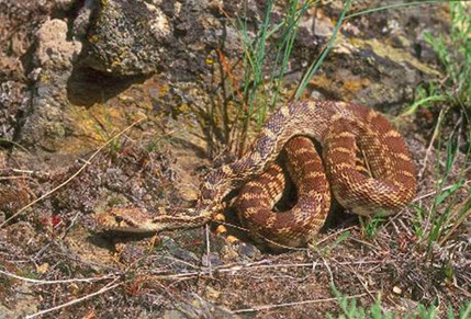
The Gopher Snake is widely distributed in western North America but occurs mostly east of the Cascade Mountains (COSEWIC 2013; Figure 2). The species reaches its northernmost distribution in south-central British Columbia. In the United States, its range extends eastward to western Colorado and southward to southeastern California and northern Arizona and New Mexico.
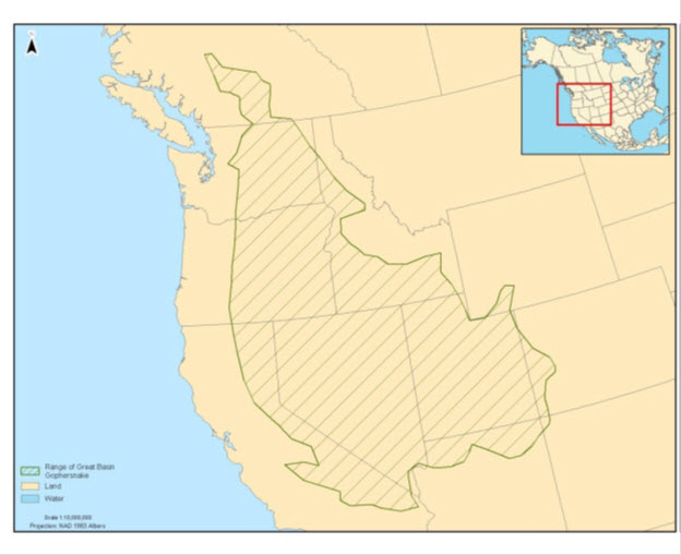
Long description for Figure 2
A map of western North America shows that the range of the Gopher Snake deserticola subspecies occupies a roughly triangular patch extending from southern California/Nevada, east to the western edge of Colorado, and then northwards into Washington State and the South of British Columbia. As the range extends northwards from the United States, it narrows significantly so that a relatively thin corridor extends into British Columbia.
In Canada, the Gopher Snake, deserticola subspecies, occurs in the dry interior of south-central British Columbia in the Okanagan, Lower Similkameen, Kettle, Nicola, Thompson, and Fraser watersheds (COSEWIC 2013; Figure 3). They are found in four geographic areas in the province (Figure 3): Fraser–Thompson–Nicola, Okanagan–Similkameen, Midway, and Grand Forks. These areas are disjunct in Canada, but the three areas along the United States border may be connected through Washington State. The Gopher Snake is recorded in the dry, hot Bunchgrass, Ponderosa Pine, and Interior Douglas-fir biogeoclimatic zones mostly below 1000 m elevation but may occur up to 1700 m (COSEWIC 2013). Canada has less than 5% of the global distribution of the Gopher Snake, deserticola subspecies (Southern Interior Reptile and Amphibian Recovery Team 2008).
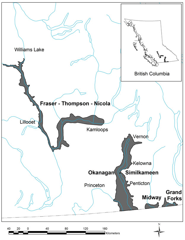
Long description for Figure 3
A map of Southern British Columbia shows that the habitat of the Gopher Snake deserticola subspecies occupies two discontinuous stretches in the Fraser-Thompson-Nicola river valley and in the Okanagan-Similkameen river valley. The Fraser-Thompson-Nicola patch is northwest of the Okanagan-Similkameen Patch. The width of these patches is relatively narrow.
Haney and Sarell (2007) modeled suitable Gopher Snake habitat in the province and estimated 76 808 ha (9%) occur on land protected by various conservation tenures. The remaining habitat was on Crown land (399 046 ha, 46%), private land (234 658 ha, 32%), and Indian Reserve (94 259 ha, 12%).
No comprehensive inventory has been done for the Gopher Snake, but the B.C. Conservation Data Centre (2016) estimates that 2500–10 000 individuals occur in the province. Gopher Snake population trends are poorly understood but are presumed to be declining owing to historical and current habitat loss and fragmentation, resulting from urban and agriculture developments and ongoing road mortality (COSEWIC 2013). Substantial habitat loss has been reported (Lea 2008). Anecdotal observations suggest population declines throughout much of the species’ range in British Columbia (Bertram et al. 2001; Hobbs 2001; Sarell, pers. comm., 2007).
The Gopher Snake is restricted to the arid interior of British Columbia, where it occupies the dry, hot Bunchgrass, Ponderosa Pine, and Interior Douglas-fir biogeoclimatic zones (COSEWIC 2013). The species uses various open and semi-open habitats (Gregory and Campbell 1984). At a finer scale, they are associated with cliff, talus, rock outcrops, riparian areas, wetland vegetation, grassland, shrub–steppe, and open forest habitats. Most records are below 1000 m elevation but “may occasionally be found at elevations up to 1700 m” (COSEWIC 2013). The Gopher Snake requires habitat for hibernation, migration, foraging, egg-laying, and shedding. Typically, substantial overlap occurs among these habitats and connectivity between all seasonally used habitats is important.
The Gopher Snake usually returns to hibernacula (referred to as “dens” in this document) between September and mid-October (COSEWIC 2013) but may move toward dens as early as late July (Shewchuk 1996) or as late as November (Hobbs 2001). They leave dens for foraging sites in March and April (COSEWIC 2013). Hibernation occurs underground where snakes can avoid freezing. Den depth for Gopher Snake was not available, but for Western Rattlesnake, a similar species, suitable conditions in rocky denning habitats were 0.86–3.00 m below ground Hobbs (2007). The Gopher Snake uses rock dens and soil dens, depending on availability (COSEWIC 2013).
Rock dens are usually located on warm aspects (southwest to southeast) in cliff or bedrock crevices, or talus slopes, up to about 873 m elevation (Sarell, unpubl. data in COSEWIC 2013). These dens can be shared by several other snake species (e.g., Western Rattlesnake, North American Racer, Northern Rubber Boa [Charina bottae], Common Gartersnake [Thamnophis sirtalis]) and by many individuals (up to hundreds). Security cover, such as large rocks with space underneath them or rock piles with interstitial space, is important near the den for thermal regulation once snakes emerge in spring. Rock dens can persist for many generations and snakes that use rock dens typically have high fidelity to these sites (Williams et al. 2014a; COSEWIC 2013). Rock dens were used by 17 of 18 (94%) snakes in Williams’ South Okanagan study area, where rock dens appeared to be more available, with only 1 of 18 using a soil den. In addition, 5 of 5 (100%) rock dens were reused in the next year. Temperatures measured at rock dens in British Columbia, often shared with Western Rattlesnakes, were between 3°C and 9°C (Macartney 1985; Hobbs 2007).
Soil dens are most often on south-facing grassy hillsides but may also be on flat areas with no obvious aspect (Shewchuk 1996; Bertram et al. 2001; White 2008). Gopher Snakes also have hibernated in the rock fill supporting road beds and railway lines (Bertram et al. 2001; Sarell, pers. comm., 2016). Soil dens on grassy hillsides were in rodent burrows (Williams et al. 2014a). In Williams’ Vernon study area, where rock dens were not abundant, 11 of 16 (69%) snakes hibernated in soil dens with two in natural rock dens and three in rock fill associated with parking lot construction. Most Gopher Snakes (25 of 33, 75.8%) in soil dens hibernate alone, and only 2 of 7 (28.6%) snakes that hibernated in rodent burrows were observed to reuse den sites the next year. Williams et al. (2014a) suggested that den sites in rodent burrows may be unstable over the long term and that these types of dens are likely readily available. Overwinter survival in soil dens was high (Williams et al. 2014a). Individual soil dens are difficult to detect without telemetered animals, but suitable sites can be mapped based on habitat and rodent burrow availability.
Tables 1 and 2 present a summary of functions, features, and attributes for hibernation (denning) habitat.
| Life stage(s) | Functiona | Feature(s)b |
|---|---|---|
| All, including eggs | Hibernation | Dens (hibernacula) |
a Function: a life-cycle process of the species (e.g., hibernation).
b Feature: the essential structural components of the habitat required by the species.
| Attributec | Description |
|---|---|
| Elevation | Rock dens are recorded up to about 873 m elevation. |
| Climate | Dry, hot, Bunchgrass, Ponderosa Pine, Interior Douglas-fir biogeoclimatic zones in the southern interior of British Columbia. |
| Habitat types | Dry, hot, Bunchgrass, Ponderosa Pine, Interior Douglas-fir biogeoclimatic zones in the southern interior of British Columbia. |
| Availability | Typically October through March; sometimes earlier (e.g., July through March). |
| Aspect | Southwest to southeast aspects but may occasionally be found in flat areas with no obvious aspect. |
| Structure | Rock dens: cliff, talus, or earth-covered rock outcrop with cracks or fissures that provide access below the frost line. Soil dens: deep-soiled grassland with rodent burrows. |
| Temperature | Stable temperature approximately 3–9°C throughout the hibernation season. |
| Humidity | Suitable humidity to prevent desiccation is likely important but details are unknown. |
c Attribute: the building blocks or measurable characteristics of a feature.
The Gopher Snake uses foraging habitat from spring (after leaving dens in March and April) until autumn, and usually returns to dens between September and mid-October (COSEWIC 2013). Foraging habitat overlaps with migration, mating, egg-laying, shedding, and basking habitat (COSEWIC 2013). Retreat sites (i.e., security habitat) are an essential component of foraging habitat where snakes can more safely digest prey and thermoregulate, while avoiding predation (COSEWIC 2013).
Foraging habitat includes grasslands, shrub–steppe, riparian areas, wetlands, open ponderosa pine (Pinus ponderosa) and Rocky Mountain Douglas-fir (Pseudotsuga menziesii var. glauca) forest, talus, rock outcrop and agricultural edge habitat where prey is available (COSEWIC 2013). Rock outcrops, large rocks, rock piles, talus, bluffs, live and dead shrubs, fallen trees, coarse woody debris, rodent burrows, concrete berms, and other cover objects are important features as they provide safe retreat sites for security habitat and thermoregulation (COSEWIC 2013). Snakes can remain underground in rodent burrows for several days during hot summer weather (Parker and Brown 1980). The Gopher Snake appears to have high site fidelity to foraging sites in consecutive years (Parker and Brown 1980).
In the spring and autumn, Gopher Snakes undertake relatively rapid (a few days) direct movements between hibernation sites and summer foraging areas, sometimes covering several hundred metres (Shewchuk 1996; COSEWIC 2013). Movement corridors may be affected by local topography. In British Columbia, average maximum movement distances from hibernation sites to summer foraging areas are 934 m (Shewchuk 1996; N = 3), 453 m (Bertram et al. 2001; N = 3), and 520 m (Williams et al. 2012; N = 39). Average movement from dens varied annually from 755 m in 2006 to 1191 m in 2007 at Vaseux Lake, which had the longest average movement distance of White’s four study sites (White 2008). The longest reported movement distance from a hibernation site to and from a foraging site in the province is 2365 m (White 2008). A male Gopher Snake repeated this movement pattern in two consecutive years. Once at a foraging area, daily movements centred around specific retreat sites and averaged 153 m for females and 124 m for males (Shewchuk 1996).
Home ranges overlap among individuals and between sexes (COSEWIC 2013). Home range sizes varied between 1.08 ha for a gravid female and 66.74 ha for a male, and averaged 11 ha in the Okanagan (White 2008). Home range size is statistically similar between males and females (COSEWIC 2013). Shewchuk calculated average home ranges of 13.9 ha for females (N = 7) and 5.3 ha for males (N = 5) near Osoyoos. Bertram et al. (2001) noted one female home range of 25 ha and two male home ranges of 5 ha and 18 ha near Kamloops. The shape of home ranges (length, width, and size) varied with local topography and also varied annually, with one snake showing a 24 ha change in home range size between years (White 2008).
The Gopher Snake is an active forager, as opposed to the sit and wait approach typically employed by rattlesnakes. They feed primarily on small mammals, but also eat birds and bird eggs, lizards, and other snakes (COSEWIC 2002; COSEWIC 2013). McAllister et al. (in prep.) identified 38 prey items from road-killed Gopher Snakes in the South Okanagan. Thirty-two (84%) were small mammals and six (16%) were birds. Mammals included North American Deer Mouse (Peromyscus maniculatus; 32%), vole (Microtus spp.; 18%), shrew (Sorex sp.; 13%), Great Basin Pocket Mouse (Perognathus parvus; 8%), Nuttall’s Cottontail (Sylvilagus nuttallii; 5%), Northern Pocket Gopher (Thomomys talpoides; 5%), and Western Harvest Mouse (Reithrodontomys megalotis; 3%).
Mating occurs shortly after leaving the den, usually in May (COSEWIC 2013). Females mature at 3–5 years and lay 2–8 eggs in June or July (COSEWIC 2013). Some females (> 40%) may not lay eggs annually (COSEWIC 2013). Shewchuk (1996) reported that less than 40% of snakes were gravid at Osoyoos, but “the majority” of White’s (2008) study animals were gravid in the Okanagan. Larger females lay more eggs on average (COSEWIC 2013). Eggs hatch from late August to early September (Shewchuk 1996). Egg-laying sites are often located on warm aspect grassland or shrub–steppe slopes where tall vegetation is limited and the ground is exposed to the sun, helping to incubate the eggs (COSEWIC 2013). Females Gopher Snakes may move substantial distances (440–2188 m) to egg-laying sites (Shewchuk 1996; Bertram et al. 2001); however, White (2008) reported egg-laying sites averaged 234 m from the den site (N = 13), with a maximum of 605 m.
Slopes where eggs were laid averaged 32° (N = 9) in the south near Oliver and 43° (N = 7) in the north near Vernon (White 2008). Ground cover was mainly grass and exposed soil in the Okanagan (Williams et al. 2014a). Egg-laying occurs in rodent burrows, on talus slopes, in rock fissures, and under decaying wood (COSEWIC 2002; Williams et al. 2014a) at depths of 5–10 cm (Williams et al. 2014a). Rodent burrows are sometimes modified and enlarged by the snakes (Shewchuk 1996). Loose, sandy soils on south-facing aspects appear to be important (Williams et al. 2014a). The authors quantified soil particle size as mostly less than 2 mm (71.4%). In relation to availability, sandy loam, loamy sand, and silty loam were statistically selected, and loam, silty clay loam, clay loam, and sand were statistically avoided. Despite the statistics, the authors found one nest in loam and one in silty clay loam (N = 8), so these soils types are used but may be less preferred. Gopher Snakes sometimes lay eggs communally with several other Gopher Snakes and/or other snake species such as North American Racer (Shewchuk 1996). This behaviour was not common in Williams et al.’s (2014a) study area, where 94% of snakes did not use communal egg-laying sites. Some (20%, N = 5) egg-laying sites were re-used annually over a 2-year period (White 2008).
Shedding of skin (ecdysis) occurs from June through August but peaked in June and July (Shewchuk 1996; White 2008) and occurred more than once per season (White 2008). Shedding often occurred at rock features (White 2008) for cover. Vision is impaired by an exudate between the old and new skin, making them more vulnerable to predators (Klauber 1997). Some of these sites may be used by several snakes and sites often were re-used (White 2008). Some snakes shed in grasses, shrubs, or objects such as old cars (Sarell, pers. comm., 2016).
Basking (exposure to the sun to increase temperature) is important for Gopher Snakes, which are ectotherms. Although information is not available for Gopher Snakes, Western Rattlesnakes bask for an average of 25% (in forest habitat) to 42% (in open habitat) of their time daily (Harvey 2015). Basking can occur in various habitats that have exposure to sunlight. Thermoregulation to increase temperature may also be achieved through warm substrates (Lomas 2013), which can include natural habitats such as rocks or human-created habitats such as roads.
Tables 3 and 4 present a summary of functions, features, and attributes for foraging/migration habitat.
| Life stage(s) | Functiond | Feature(s)e |
|---|---|---|
| All, including eggs | Foraging, Hibernation, dispersal, mating, egg-laying, incubation, shedding | Grassland, shrub–steppe, talus, rock outcrop, riparian, wetland vegetation, open ponderosa pine or Douglas-fir forest |
d Function: a life-cycle process of the species (e.g., foraging, migration, mating).
e Feature: the essential structural components of the habitat required by the species.
| Attributef | Description |
|---|---|
| Elevation | Up to about 1000 m elevation and may occasionally occur up to 1700 m. |
| Climate | Dry, hot, Bunchgrass, Ponderosa Pine, Interior Douglas-fir biogeoclimatic zones in the southern interior of British Columbia. |
| Habitat types | Cliff, talus, rock outcrop, grassland, shrub–steppe, riparian, wetland, open ponderosa pine and Rocky Mountain Douglas-fir forest. Agricultural and urban habitats may be used but the risk of mortality is increased. |
| Availability | March through October. |
| Distance from den | Average movements from dens to foraging areas are ~520 m, with a recorded maximum of about 2.4 km. |
| Retreats | Rock outcrops, large rocks, rock piles, talus, bluffs, live and dead shrubs, fallen trees, coarse woody debris, rodent burrows, and concrete berms. |
| Shedding retreats | Rock outcrops, large rocks, rock piles, talus, and concrete berms where communal shedding occurs, often over more than 1 year. Basking often takes place in sunny areas near retreats. |
| Prey | Various small mammals (rodents and shrews), birds, and snakes. |
| Egg laying sites | South-facing grassland or open shrub–steppe with rodent burrows, talus slopes, rock fissures, or decaying wood, generally on loose soils with particle sizes of less than 2 mm. |
| Other | Low densities of housing, agriculture, roads and vehicle traffic, all of which increase potential for direct mortality and related gene flow, and may cause barriers to movement. |
f Attribute: the building blocks or measurable characteristics of a feature.
Longer movements, outside of the species’ normal home range, may occur across additional terrestrial habitat, allowing for colonization of new sites and/or between local sites. These occasional movements are not part of regular seasonal habitat use but are considered dispersal movements, and the additional terrestrial habitat required to meet this species’ need is termed “connectivity” habitat. Connectivity habitat is essential to support gene flow and long-term persistence of viable subpopulationsFootnote1.2 of snakes within the landscape.
Subpopulations that are isolated and have limited genetic diversity can be more susceptible to disease and increased mortality owing to inbreeding depression (Clark et al. 2011). For example, Clark et al. (2011) documented that loss of connectivity resulted in genetic isolation that contributed to physical abnormalities and disease, likely because of inbreeding depression, in a small population of Timber Rattlesnake (Crotalus horridus) in New Hampshire. Clark et al. (2010) stated “roads are extremely effective barriers to gene flow” in Timber Rattlesnakes, despite the relatively short time period that paved, high-speed roads have existed. Although roads may not necessarily be barriers to movement, they are barriers to gene flow related to direct mortality from vehicles. Maintaining this connectivity, for both movement and gene flow, is important to ensure long-term population viability. Very little is known about long-distance dispersal in British Columbia. The longest recorded movement within a home range in the province is about 2.4 km (White 2008), and therefore dispersal distances likely are greater than 2.4 km. NatureServe uses 10 km in suitable habitat as a separation distance between populations and 1 km in unsuitable habitat (Hammerson 2013). Research on this topic is needed. It is assumed that dispersal/connectivity habitat is similar to foraging habitat (see Section 3.3.2).
Tables 5 and 6 present a summary of functions, features, and attributes for dispersal/connectivity habitat.
| Life stage(s) | Functiong | Feature(s)h |
|---|---|---|
| All | Dispersal | Grassland, shrub–steppe, riparian, open ponderosa pine or Douglas-fir forest |
g Function: a life-cycle process of the species (e.g., dispersal between sites and subpopulations).
h Feature: the essential structural components of the habitat required by the species.
| Attributei | Description |
|---|---|
| Elevation | Up to at least 1000m elevation and possibly up to 1700 m. |
| Climate | Dry, hot, Bunchgrass, Ponderosa Pine, Interior Douglas-fir biogeoclimatic zones in the southern interior of British Columbia. |
| Availability | April through October. |
| Structure | Rock outcrops, large rocks, rock piles, talus, bluffs, live and dead shrubs, fallen trees, coarse woody debris, rodent burrows, and some concrete structures. |
| Shedding structure | Rock outcrops, large rocks, rock piles, talus, concrete berms where communal shedding occurs, often over more than 1 year. |
| Distance from den | Unknown but likely to include distances greater than 2.4 km. |
| Prey | Various small mammals (rodents and shrews) and birds. |
| Other | Low densities of housing, agriculture, roads and vehicle traffic, all of which increase potential for direct mortality, and related gene flow, and may cause barriers to movement. |
i Attribute: the building blocks or measurable characteristics of a feature.
The Gopher Snake plays an important role in the food chain in shrub–steppe, grassland, and open, dry forest ecosystems, as predator and prey. As a small mammal predator, the Gopher Snake may help to limit rodent populations; they also eat birds and lizards. As a prey species, Gopher Snake is a prey item for raptors (e.g., Red-tailed Hawk [Buteo jamaicensis]), American Badger (Taxidea taxus), Striped Skunk (Mephitis mephitis), Coyote (Canis latrans), and Long-tailed Weasel (Mustela frenata) (COSEWIC 2002; White 2008).
Limiting factors are generally not human-induced and include characteristics that make the species less likely to respond to recovery/conservation efforts (e.g., inbreeding depression, long-lived species with low rate of reproduction, genetic isolation). Gopher Snake recovery is limited by a number of natural factors. They use rock dens in some areas where large numbers of animals congregate, making them vulnerable to catastrophic events (COSEWIC 2013). They have delayed sexual maturity (3–5 years in females), a relatively low reproductive rate (2–8 eggs per female) and more than 40% of females lay eggs only every second year in some areas (Shewchuk 1996).
Threats are defined as the proximate activities or processes that have caused, are causing, or may cause in the future the destruction, degradation, and/or impairment of the entity being assessed (population, species, community, or ecosystem) in the area of interest (global, national, or subnational) (Salafsky et al. 2008). For purposes of threat assessment, only present and future threats are considered.Footnote2.1 Threats do not include limiting factors, which are presented in Section 3.5.Footnote3.2
For the most part, threats are related to human activities, but they can also be natural. The impact of human activity may be direct (e.g., destruction of habitat) or indirect (e.g., invasive species introduction). Effects of natural phenomena (e.g., fire, hurricane, flooding) may be especially important when the species or ecosystem is concentrated in one location or has few occurrences, which may be a result of human activity (Master et al. 2012). As such, natural phenomena are included in the definition of a threat, though they should be considered cautiously. These stochastic events should only be considered a threat if a species or habitat is damaged from other threats and has lost its ability to recover. In such cases, the effect on the population would be disproportionately large compared to the effect experienced historically (Salafsky et al. 2008).
The threat classification below is based on the IUCN–CMP (World Conservation Union–Conservation Measures Partnership) unified threats classification system and is consistent with methods used by the B.C. Conservation Data Centre. For a detailed description of the threat classification system, see the Open Standards website (Open Standards 2014). Threats may be observed, inferred, or projected to occur in the near term. Threats are characterized here in terms of scope, severity, and timing. Threat “impact” is calculated from scope and severity. For information on how the values are assigned, see Master et al. [PDF, 1.6 Mb] (2012) and table footnotes for details. Threats for the Gopher Snake, deserticola subspecies, were assessed for the entire province (Table 7).
| Threat #j | Threat description | Impactk | Scopel | Severitym | Timingn |
|---|---|---|---|---|---|
| 1 | Residential and commercial development | Low | Small | Serious | High |
| 1.1 | Housing and urban areas | Low | Small | Serious | High |
| 1.2 | Commercial and industrial areas | Negligible | Negligible | Extreme | High |
| 1.3 | Tourism and recreation areas | Negligible | Negligible | Moderate | High |
| 2 | Agriculture and aquaculture | Low | Pervasive | Slight | High |
| 2.1 | Annual and perennial non-timber crops | Low | Small | Serious | High |
| 2.3 | Livestock farming and ranching | Low | Pervasive | Slight | High |
| 3 | Energy production and mining | Negligible | Negligible | Extreme | High |
| 3.2 | Mining and quarrying | Negligible | Negligible | Extreme | High |
| 3.3 | Renewable energy | Negligible | Negligible | Unknown | Moderate |
| 4 | Transportation and service corridors | High | Pervasive | Serious | High |
| 4.1 | Roads and railroads | High | Pervasive | Serious | High |
| 4.2 | Utility and service lines | Negligible | Negligible | Slight | High |
| 5 | Biological resource use | Low | Pervasive | Slight | High |
| 5.1 | Hunting and collecting terrestrial animals | Low | Pervasive | Slight | High |
| 5.3 | Logging and wood harvesting | Unknown | Small | Unknown | High |
| 6 | Human intrusions and disturbance | Low | Pervasive | Slight | High |
| 6.1 | Recreational activities | Low | Pervasive | Slight | High |
| 6.2 | War, civil unrest, and military exercises | Negligible | Negligible | Negligible | High |
| 7 | Natural system modifications | Low | Pervasive | Slight | High |
| 7.1 | Fire and fire suppression | Low | Pervasive | Slight | High |
| 8 | Invasive and other problematic species, genes and diseases | Low | Restricted | Slight | High |
| 8.1 | Invasive non-native/alien species/diseases | Low | Restricted | Slight | High |
| 8.2 | Problematic native species/diseases | Unknown | Restricted | Unknown | High |
| 9 | Pollution | Low | Restricted–Small | Moderate | High |
| 9.3 | Agricultural and forestry effluents | Low | Restricted–Small | Moderate | High |
| 10 | Geological events | Negligible | Negligible | Extreme | High |
| 10.3 | Avalanches/landslides | Negligible | Negligible | Extreme | High |
| 11 | Climate change and severe weather | Negligible | Negligible | Extreme | High |
| 11.4 | Storms and flooding | Negligible | Negligible | Extreme | High |
j Threat numbers are provided for Level 1 threats (i.e., whole numbers) and Level 2 threats (i.e., numbers with decimals).
k Impact – The degree to which a species is observed, inferred, or suspected to be directly or indirectly threatened in the area of interest. The impact of each threat is based on severity and scope rating and considers only present and future threats. Threat impact reflects a reduction of a species population. The median rate of population reduction for each combination of scope and severity corresponds to the following classes of threat impact: Very High (75%), High (40%), Medium (15%), and Low (3%). Unknown: used when impact cannot be determined (e.g., if values for either scope or severity are unknown); Not Calculated: impact not calculated as threat is outside the assessment time (e.g., timing is insignificant/negligible [past threat] or low [possible threat in long term]); Negligible: when scope or severity is negligible; Not a Threat: when severity is scored as neutral or potential benefit.
l Scope – Proportion of the species that can reasonably be expected to be affected by the threat within 10 years. Usually measured as a proportion of the species’ population in the area of interest. (Pervasive = 71–100%; Large = 31–70%; Restricted = 11–30%; Small = 1–10%; Negligible < 1%).
m Severity – Within the scope, the level of damage to the species from the threat that can reasonably be expected to be affected by the threat within a 10-year or three-generation time frame. For this species a generation time of 8 years was used, resulting in severity being scored over a 24-year time frame. Severity is usually measured as the degree of reduction of the species’ population. (Extreme = 71–100%; Serious = 31–70%; Moderate = 11–30%; Slight = 1–10%; Negligible < 1%; Neutral or Potential Benefit ≥ 0%).
n Timing – High = continuing; Moderate = only in the future (could happen in the short term [< 10 years or three generations]) or now suspended (could come back in the short term); Low = only in the future (could happen in the long term) or now suspended (could come back in the long term); Insignificant/Negligible = only in the past and unlikely to return, or no direct effect but limiting.
The overall province-wide Threat Impact for this species is High.Footnote4 This overall threat considers the cumulative impacts of multiple threats. The greatest threat to the Gopher Snake is direct mortality from road traffic. Lower-ranked threats include habitat loss and fragmentation from housing, agriculture, recreation, and fire suppression; potential diseases from invasive non-native/alien species; as well as direct harm or mortality from recreation, persecution, and pollution (Table 7). Details are discussed below under the Threat Level 1 headings.
Substantial overlap exists in the low-elevation habitats where both Gopher Snake and urban growth generally occur. The impacts of urban development are likely most severe in the Okanagan Valley and Kamloops areas (Dyer, pers. comm., 2016) and affects all life stages (COSEWIC 2013). Housing and urban areas cause direct loss of habitat through the footprint of houses, landscaping, and roads. Rock dens are affected occasionally, but soil dens are more likely to be destroyed during development in open grassland or shrub–steppe habitat. Foraging habitat, retreat sites, and egg-laying sites are also permanently destroyed. Lomas et al. (2015) suggested that indirect disturbance, as opposed to direct habitat loss, may affect survival, recruitment, and population stability in Western Rattlesnake. This may also apply to the Gopher Snake, since both species depend on similar habitats and prey species. This threat also creates barriers to movement and increases mortality related to roads and persecution (also, see Threats 4 and 5, below). Commercial and industrial areas, as well as tourism and recreation areas have similar impacts, but the scope is thought to be Negligible.
Impacts from annual and perennial non-timber crops are most severe in the Okanagan, lower Similkameen, and Nicola valleys where vineyards are expanding (COSEWIC 2013). Intensive agriculture can destroy soil dens, egg-laying sites, and retreat sites such as rocks, shrubs, and rodent burrows, which are important for cover. Movement corridors may be disrupted, rodent prey species are likely reduced, and accidental mortality associated with the use of farm machinery increases (Bertram et al. 2001; Lomas, pers. comm., 2014). Snake mortality, from becoming trapped in plastic mesh used during construction in commercial orchards/vineyards and in urban gardens, appears to be an emerging issue (Bishop, pers. comm., 2016). Direct persecution also occurs, often because Gopher Snakes are mistaken for the venomous Western Rattlesnake, although programs such as “Snake Smart” have reduced impacts at some sites (Okanagan Similkameen Conservation Alliance 2016). This threat affects all life stages.
Livestock farming and ranching occurs throughout the species’ range, and impacts are likely variable, depending on the location of grazing (e.g., upland or riparian), terrain features, and localized grazing intensity (i.e., stocking levels). Intensive grazing by livestock can reduce vegetative cover for Gopher Snakes and their small mammal prey (Bock et al. 1984; Hobbs and Sarell 2000; Ovaska et al. 2004; Rickel 2005; Forest Practices Board 2007), which may reduce prey abundance (Fleischner 1994) in some cases. Livestock may contribute to increases in non-native plant species (Gayton 2004), particularly cheatgrass (Bromus tectorum), which is linked to Gopher Snake declines in some areas (Hall et al. 2009 in COSEWIC 2013). Disturbance related to grazing may result in lower body condition, slower growth rates, and reduced fecundity as seen in Western Rattlesnake, a similar species, in Idaho (Jenkins et al. 2009).
Mining and quarrying can have substantial local impacts owing to loss of denning, foraging, and egg-laying habitat, particularly for rock dens that are often re-used annually, and direct mortality during excavation works (COSEWIC 2013); however, few mines or gravel pits are expected to overlap with Gopher Snake habitat in the near future. Renewable energy may also affect habitat and cause direct mortality, little overlap is evident with Gopher Snake habitat (COSEWIC 2013). The impact for this threat is Negligible.
Roads and railroads present the highest impact threat for the Gopher Snake, owing to the ongoing mortality caused by vehicles; this threat occurs throughout the species’ range (COSEWIC 2013). Roads also cause permanent habitat loss and may create barriers to movement in some cases where ditch banks are too steep for snakes to climb and concrete barriers do not have holes that allow passage, or when holes become plugged. Snakes are attracted to warm, paved surfaces for basking, and their seasonal migratory movements between hibernacula and summer foraging areas are often intersected by roads. These behaviours make them vulnerable to road mortality (Fortney et al. 2012). In addition, some drivers admit to intentionally hitting snakes on roads (Sarell, pers. comm., 2013; Hobbs, pers. comm., 2014). In Ontario, for example, 2.7% of drivers intentionally hit herpetofauna (Ashley et al. 2007). This threat affects neonates, juveniles, and adults. Williams et al. (2014b) recorded three road kills from 39 telemetered snakes over 2 years in the Okanagan Valley, representing 18% (N = 17) of mortalities and a mortality rate of about 4% of the study population per year. Natural mortality was already very high in this study. Fourteen (36%) of these telemetered (adult) snakes died in a 2-year period, suggesting additional, human-caused, mortality may be unsustainable.
Road impacts vary with type of road, traffic volume, and distance from dens. In Saskatchewan, Fortney et al. (2012) reported snake mortality rates, including Bullsnake (Pituophis catenifer sayi), on paved roads (18 of 36, 50%), gravel roads (16 of 36, 44%), and trails (2 of 36, 6%) but found higher numbers of live snakes on gravel roads (13 of 18, 17%). Snakes selected paved road significantly more than expected and twice as many dead snakes were found on paved roads than expected, based on paved road availability in the study area. Distance to den was a key factor in predicting road mortality in addition to traffic volume and road type. Hobbs (2013) found 49% of Western Rattlesnake rock dens, which are often shared with Gopher Snakes, occur within 1 km of a paved road and an additional 27% are within 2 km.
Population modeling suggests catastrophic consequences of ongoing mortality from road kill. Row et al. (2007) estimated that road mortality of nine Black Ratsnakes (Elaphe obsolete) per year increased extinction probability in their stable study population from 7.3% to 99% over 500 years. Road mortality of just three adult females per year, out of an estimated population of 400 adults, increased the extinction probability to more than 90%. Rudolph et al. (1999) reported that populations of large snakes (i.e., Louisiana Pine Snake [Pituophis ruthveni]) within 450 m of a road could be reduced by more than 50%, with population reductions continuing up to 850 m even on moderately traveled roads. Kirk et al. (2016) modeled Western Rattlesnake habitat in British Columbia, which has substantial overlap with Gopher Snake habitat; population estimates declined from 31 535 to 17 375 individuals when impacts from roads and agriculture were included in the model. Also in British Columbia, Reed (2013) predicted a Gopher Snake population reduction over 24 years (three generations) of 40–50%, if road mortality affected adults only, and up to 90% if road mortality affected all age classes.
Utility and service lines also cause habitat loss and ongoing mortality, but the impact on the Gopher Snake is thought to be Negligible over the next 10 years owing to Negligible scope and Slight severity.
The Gopher Snake is often mistaken for the venomous Western Rattlesnake and is sometimes intentionally killed as a result (COSEWIC 2013). They are also killed occasionally simply because they are snakes (COSEWIC 2013), despite legal protection under the province’s Wildlife Act. Snakes are occasionally captured and kept as pets.
Low-elevation logging and wood harvesting may cause accidental mortality during construction of access roads and harvesting or hauling of timber. Habitat changes from dense forest to open forest or grassland may benefit the Gopher Snake. The scope is likely Small and severity has not been researched; therefore, the impact of logging is Unknown.
Recreation activities pose a threat to Gopher Snakes, owing to disturbance, habitat modification or damage, and accidental mortality. Vehicles may collapse burrows of prey species and damage retreat and egg-laying sites (COSEWIC 2013). In British Columbia, the impacts of activities such as off-road vehicle use and mountain biking have received no research, but both activities are prevalent within Gopher Snake range and have been observed to cause accidental mortality in snake species (Sarell, pers. comm., 2013). Although this threat is currently thought to have a Low impact, a 20-year study of the Pine Snake in New Jersey (Burger et al. 2007) found that the percentage of young was significantly lower (16%) in years of off-road vehicle use when compared to years without use (28%). This research suggests that the impacts of off-road vehicles can be serious at some sites, and research is required to clarify this threat in the province.
Although many human activities (e.g., hiking, camping) within wilderness areas are considered benign, they may still cause changes in animal behaviour, such as altered feeding patterns and increased energetic costs, which may have survival consequences. Human disturbance in a park setting was shown to cause behavioural changes in eastern Massasauga Rattlesnakes, although no population-level impacts were detected (Parent and Weatherhead 2000). In the South Okanagan, Western Rattlesnake residing in highly human-disturbed habitat lost weight over the foraging season and had lower body condition compared to snakes in undisturbed habitat, despite no major differences in behaviour or spatial ecology (Lomas 2013); similar effects may occur for Gopher Snakes since they use similar habitats and utilize similar prey species.
The Vernon Military Camp has a subpopulation of Gopher Snake that has been researched with support from the Department of National Defence (White 2008). The threat from military exercises is minimal (Dyer, pers. comm., 2016) and the site provides habitat protection in an otherwise rapidly developing landscape.
Fire suppression changes habitat features over time by increasing shrub and tree cover in grassland and shrub–steppe habitats (COSEWIC 2013). As a result, shading can potentially reduce basking and other thermal habitat features, and vegetation changes can also alter foraging habitats, prey type, and abundance, which may affect habitat suitability. Fire suppression can lead to fuel build-up over time, potentially resulting in hot-burning and catastrophic wildfire. Although snakes can avoid light burns by retreating underground, hot fires may be inescapable. Prey abundance may temporarily decrease. Fireguards constructed during active fire suppression can also result in accidental mortality, as well as habitat loss and den destruction. The impact from this threat is thought to be Low.
Domestic animals (primarily cats) may pose a threat to Gopher Snakes, especially young snakes (COSEWIC 2013). The degree to which Gopher Snakes are predated by domestic animals in the province is unknown. Loss et al. (2013) quantified cat predation on wildlife; they estimated that 258–822 million reptiles could be killed annually by cats in the United States, but concluded that effects on populations remain unknown. The impact in British Columbia is thought to be Low because of a Restricted scope and Slight severity.
Snakes are susceptible to fungal diseases. Ophidiomyces ophiodiicola is a fungus that to date has been detected only in eastern United States rattlesnake populations (Allender et al. 2011). Snake Fungal Disease can cause 100% mortality in snakes that are infected. Although this fungus is not known to occur in the province, this is an emerging issue that could be particularly devastating, if the fungus spreads. This threat requires monitoring.
Raccoon (Procyon lotor) and Common Raven (Corvus corax) are potentially problematic native species that eat Gopher Snakes. They have expanded their ranges and numbers in the province (Hatler et al. 2008; Environment Canada 2015). However, their impact on the Gopher Snake is Unknown.
Strychnine is used for rodent control, mostly for Northern Pocket Gopher (Thomomys talpoides), in vineyards and orchards in the dry interior of British Columbia (COSEWIC 2015). A large amount (average: 13 338 kg per year) of strychnine-based rodenticide was sold in this area between 1991 and 2002 (Vakenti, pers. comm., 2006). No recent figures were available, but use of strychnine may have temporarily declined because of reduced product availability (Hollinger, pers. comm., 2016). No snake deaths related to secondary poisoning from rodenticide have been confirmed, but no research has been done on the topic (COSEWIC 2015). Bishop et al. (2016) modeled the risk of Gopher Snake poisoning by strychnine bait in the Okanagan and suggested it could present a substantial impact. Several other rodenticides are also used in the province (Health Canada 2013), but the impacts on the Gopher Snake have not been investigated.
Impacts from garbage and solid waste are Unknown, but snakes have been caught in discarded agricultural netting (Lomas, pers. comm., 2014; Bishop, pers. comm., 2016). The threat is thought to be Low, but additional research is required to clarify impacts associated with this issue.
Gopher Snakes may be vulnerable to avalanches or landslides, mainly at rock and talus dens. Slopes and hillsides may be susceptible to washouts and slope failures, causing direct mortality and loss of important habitat features such as hibernacula and egg-laying sites. The impact on snake populations could be substantial locally, particularly if dens are destroyed and large numbers of snakes are killed. As an example, a hillside slump in Grassland National Park caused up to 90% mortality of hibernating snakes (Hobbs, pers. comm., 2014). In British Columbia, slumping caused by heavy rains has been observed in snake habitat, but no data exist to quantify the effects on snakes (Sarell, pers. comm., 2013). The impact is thought to be Negligible owing to a limited scope, despite potentially Extreme severity where it occurs.
The impacts from droughts and temperature extremes on the Gopher Snake over the next three generations (24 years) are Unknown and require research. Storms and flooding can have Extreme severity at local sites by filling burrows with water or silt and eroding egg-laying sites, but scope and impact are Negligible.
The recovery goal is to maintain or increase the abundance of Gopher Snake in each of the four geographic areas in British Columbia and to maintain or increase connectivity within these areas.
The Gopher Snake continues to decline in numbers as a result of direct mortality (road traffic) and ongoing habitat loss related to urban and agricultural development (COSEWIC 2013). Human development reduces and eliminates connectivity within and among remaining subpopulations, further exacerbating loss. Inventory gaps prevent comprehensive understanding of the current and historic range, habitat suitability, availability and use, human-caused mortality impacts, and local population trends. Sufficient information to quantify long-term population and distribution/habitat targets is not available.
The Gopher Snake was designated by COSEWIC as Threatened under criteria A3b (COSEWIC 2013). “A3b” means a suspected population reduction of 30% or greater over the next three generations (~24 years) based on an index of abundance. The causes of the suspected population decline include ongoing road mortality, persecution, and loss and/or decline in habitat quality.
Improving the species’ condition may be possible in the future, provided that threats to the habitat and subpopulations can be substantially reduced and habitat connectivity increased, so subpopulations remain viable over the long term. Increasing connectivity within geographic areas (e.g., by restoring or protecting habitat in the intervening areas and/or facilitating safe movements across roads) could help to reduce fragmentation and maintain a “rescue effect” between subpopulations.
The immediate recovery goal is to maintain or increase the population size. To accomplish this goal, objectives will include reducing mortality from roads and preventing further loss and fragmentation of the species’ habitat. More information about the population size and trends across the landscape is needed to quantify an appropriate long-term recovery goal for this species. In the short term, additional naturally occurring subpopulations should be maintained, if discovered. Restoring and protecting dispersal habitat lost to human-induced fragmentation will be important to maintain viable subpopulations within each of the four geographic areas in the province.
Sufficient information to quantify long-term population and habitat targets is not available for the Gopher Snake. The following objectives are necessary to meet the recovery goal and recover the species.
- Reduce road mortality to a level that will not affect population viability.
- Secure denning (hibernation), foraging/migration, egg-laying, and dispersal habitat throughout the species’ known range in British Columbia.
- Address knowledge gaps related to population demography, habitat quality, habitat distribution and use, priority threats, and effectiveness of recovery actions.
“Secure habitat” is Gopher Snake habitat that is managed to maintain the species for a minimum of 100 years. It includes suitably connected hibernation (denning), egg-laying, foraging, and dispersal habitat where threats are addressed. Habitat securement will require a stewardship approach that engages the voluntary cooperation of landowners and managers on various land tenures to protect this species and the habitat upon which it relies. It may include stewardship agreements, conservation covenants, ecological gifts, voluntary sale of private lands by willing landowners, land use designations, protected areas, management agreements, and continued implementation of existing legislation.
The following actions have been categorized by the action groups of the B.C. Conservation Framework (B.C. Ministry of Environment 2009). Status of the action group for this species is given in parentheses.
- COSEWIC report completed (COSEWIC 2002; COSEWIC 2013).
- Gopher Snake, deserticola subspecies, assessed as Threatened (COSEWIC 2002; COSEWIC 2013).
- Provincial Recovery Plan completed (2008; this document, 2016).
- Inventory done through several research projects (Sarell 1993; Shewchuk 1996; Sarell et al. 1998; Bertram et al. 2001; White 2008), environmental impact reports, and identified wildlife surveys.
- Monitoring of Gopher Snakes using mark/recapture and telemetry ongoing at the Nk’Mip Desert Cultural Centre, Osoyoos (Bishop, pers. comm., 2016)
- Opportunistic monitoring of rock den sites ongoing (Hobbs 2013).
- Inventory to identify sites for protection ongoing for dens (see summary in Hobbs 2013; Sarell 1993; Shewchuk 1996; Bertram et al. 2001; White 2008; environmental impact reports, identified wildlife surveys) and occupied habitat through incidental sighting reporting through Wildlife Species Inventory (B.C. Ministry of Environment 2016).
- Opportunistic inventory of road mortality ongoing at selected sites (Picard 2009; Davis 2010; Dyer, pers. comm., 2016; Winton, pers. comm., 2016, Sarell, pers. comm., 2016) to identify sites for mitigation.
- Indicators and effectiveness monitoring methods for Gopher Snake wildlife habitat areas developed (Ovaska et al. 2004).
- Conservation analysis of Gopher Snake habitat ownership completed (Haney and Sarell 2007).
- Dens and foraging habitat protected on provincial Crown conservation lands: Kalamalka Lake Park, Campbell-Brown Ecological Reserve, Okanagan Mountain Park, White Lake Provincial Park, Lac Du Bois Grasslands Park, South Okanagan Wildlife Management Area, McTaggart-Cowan/nsk’niw’t Wildlife Management Area.
- The Dominion Radio Astrophysical Observatory, Vaseux Bighorn National Wildlife Area, Agricultural Research Stations (Summerland and Kamloops) and Department of National Defence (Vernon) protect important habitats on federal Crown Land.
- Habitat protected by municipal (Kelowna’s Knox Mountain Park) and regional governments (Central Okanagan Regional District’s Mount Boucherie Regional Park).
- Eleven wildlife habitat areas, totaling 2090 ha, established under the Forest and Range Practices Act Identified Wildlife Management Strategy (Province of British Columbia 2004).
- Private land conservancies protect substantial habitat (e.g., The Nature Trust of British Columbia’s Twin Lakes, McLean Creek, Vaseux, White Lake, Kilpoola, Gilpin, and Rock Creek properties; Nature Conservancy of Canada’s Sagebrush Slopes, Sparrow Grasslands, South Block properties; Southern Interior Land Trust).
- The Okanagan Similkameen Stewardship Society (2016) and Granby Wilderness Society include the Gopher Snake in public information and landowner contact programs.
- South Okanagan–Similkameen Conservation Program and Okanagan Collaborative Conservation Program completed Keeping Nature in our Future, a biodiversity strategy for the Okanagan (South Okanagan–Similkameen Conservation Program 2012). The strategy includes detailed conservation ranking maps, analyses by local government area, and recommendations for environmentally sensitive development permit areas (White, pers. comm., 2016). A companion document on designing and implementing ecosystem connectivity in the Okanagan was produced (Latimer and Peatt 2014).
- Guidelines for Amphibian and Reptile Conservation during Urban and Rural Land Development in British Columbia were updated (Province of British Columbia 2014).
- Rock piles built for snake cover and shedding habitat during a gas line construction project in the Okanagan Valley and used by Gopher Snakes in subsequent years (Sarell, pers. comm., 2016).
- Research on various habitat- and population-related topics completed: Bertram et al. 2001; White 2008; Picard 2009; Snook and Blaine 2012; Bishop et al. 2016; Williams et al. 2012, 2014a, 2014b; Reed 2013; McAllister et al. in prep.). Additional research is ongoing (Larsen, pers. comm., 2016; Bishop, pers. comm., 2016).
- The “Snake Smart” program helped protect snakes from persecution through information, training, and support in four languages in south Okanagan vineyards (Okanagan Similkameen Conservation Alliance 2016); interpretive products include video, brochures, and posters.
- Snake refugia habitat created in one vineyard near Oliver for research (Bishop, pers. comm., 2016).
- Snake fences built to reduce mortality by stopping rattlesnakes from accessing vineyards (Oliver) (Sarell 2006), power substations (Vaseux Lake), Agricultural Research Station (Kamloops), and new urban developments (Kamloops, Vernon, Osoyoos, and Okanagan Falls).
- Best Management Practices for Amphibian and Reptile Salvages in British Columbia developed (B.C. Ministry of Forests, Lands and Natural Resource Operations 2016).
| Objective | Conservation Framework action group | Actions to meet objectives | Threato or concern addressed | Priorityp |
|---|---|---|---|---|
| 1, 2, 3 | Monitor trends | Continue to monitor population, habitat, and threat trends at the Nk’Mip site at Osoyoos and develop new, intensive, and longer-term monitoring sites in other parts of the range. | 1.1, 1.2, 2.3, 4.1, 5.1 | Essential |
| 1, 2, 3 | Monitor trends | Continue to opportunistically monitor trends related to road mortality throughout the species’ range. Develop and implement a strategic approach to quantitatively monitor road mortality at several sites across the species’ range with suitable frequency and intensity over a long term. | 4.1 | Essential |
| 1, 2, 3 | Monitor trends | Continue to opportunistically monitor den occupancy. Develop and implement a strategic approach to monitoring selected dens with greater frequency and intensity, especially sites at higher risk from habitat loss and road mortality threats. Consider the efficacy of monitoring dens and subpopulations vs. surrogate indicators of population health (e.g., habitat indicators). | 1.1, 1.2, 2.1, 2.3, 4.1, 5.1 | Necessary |
| 1, 2 | Habitat protection | Continue to inventory potential sites and record incidental sightings to identify sites for habitat protection, especially between occupied sites, to assess connectivity, and at the edges of the known range. | 1.1, 1.2, 2.1, 2.3, 4.1, 5.1, 6.1 | Essential |
| 1, 2 | Habitat protection | Continue to improve habitat protection through existing land use designations and management agreements on Crown land (e.g., protected areas, wildlife habitat areas, Land Act reserves, range use plans). | 1.1, 1.2, 2.1, 2.3, 4.1, 5.1, 6.1 | Essential |
| 1, 2 | Habitat protection | Continue working with First Nations to identify and implement opportunities for cooperative habitat conservation projects both on and off reserve land. Incorporate traditional ecological knowledge into recovery actions. | 1.1, 1.2, 2.1, 2.3, 4.1, 5.1, 6.1 | Essential |
| 1, 2 | Habitat protection | Continue to work with local governments to incorporate habitat stewardship and protection into planning processes such as official community plans, environmentally sensitive development permit areas, zoning, bylaws, and park/recreation plans (e.g., South Okanagan Similkameen Conservation Program, Regional District of Okanagan Similkameen biodiversity strategy implementation). | 1.1, 1.2, 2.1, 2.3, 4.1, 5.1. 6.1 | Essential |
| 1, 2 | Habitat protection | Continue to improve connectivity at priority sites (requires identification) and for potential rescue populations in the United States. Increase safety of connectivity habitat by reducing road mortality and movement barriers. | 1.1, 1.2, 2.1, 2.3, 4.1, 5.1 | Essential |
| 1, 2 | Habitat protection | Develop an improved inventory of historical sites that are extirpated, by conducting interviews with long-term residents, including traditional ecological knowledge specialists, and reviewing written, historic accounts. This information improves status assessment and identifies potential sites for re-introduction. | 1.1, 1.2, 2.1, 2.3, 4.1, 5.1 | Beneficial |
| 1, 2 | Habitat protection | Minimize impacts from fire suppression by developing and implementing best practices. | 7.1 | Beneficial |
| 1, 2 | Private land stewardship | Continue to acquire and manage important habitat through purchase of private lands from willing vendors (e.g., acquisitions by The Nature Trust of British Columbia; The Nature Conservancy of Canada; Southern Interior Land Trust). | 1.1, 1.2, 2.1, 2.3, 4.1, 5.1, 6.1 | Essential |
| 1, 2 | Private land stewardship | Continue to implement stewardship agreements, conservation covenants, and best management practices on private lands through voluntary agreements (e.g., Okanagan Similkameen Stewardship Society and local government stewardship agreements). | 1.1, 1.2, 2.1, 2.3, 4.1, 5.1, 6.1 | Necessary |
| 1, 2 | Private land stewardship | Continue, and expand, the “Snake Smart” program to reduce snake mortality in agricultural areas. Quantify the issue through interviews and include effectiveness monitoring. | 2.1, 2.3, 6.1 | Necessary |
| 1, 2 | Habitat restoration | Identify “hot spots” where a high level of road mortality occurs and implement mitigation (e.g., fencing with underpasses), if required; use research and adaptive management to identify effective actions to reduce or eliminate mortality and restore safe connectivity habitat, in cooperation with the Ministry of Transportation and Infrastructure. | 4.1 | Essential |
| 1, 2 | Habitat restoration | Identify and strategically reduce movement barriers in terrestrial habitat where loss of habitat and connectivity is seriously affecting population viability. | 1.1, 1.2, 2.1, 2.3, 4.1, 5.1, 6.1 | Necessary |
| 1, 2, 3 | Species and population management | Develop and initiate a prioritized research strategy to address biological knowledge gaps, clarify threats, and improve effectiveness of recovery actions in collaboration with academia. | 1.1, 2.1, 2.3, 4.1, 5.1, 6.1, 7.1, 8.1, 9.3, 11 | Essential |
| 1, 2, 3 | Species and population management | Develop and implement long-term research projects at several sites within the species’ range to clarify road mortality issues, associated population impacts, and effective mitigation options for existing and future roads, in collaboration with the Ministry of Transportation and Infrastructure and academia. | 4.1 | Essential |
| 1, 2, 3 | Species and population management | Continue to develop and deliver outreach materials to priority target audiences to increase understanding, support for and implementation of all recovery actions in collaboration with local stewardship groups. | 1.1, 2.1, 2.3, 4.1, 5.1, 6.1, 7.1, 8.1, 9.3, 11 | Essential |
| 1, 2, 3 | Species and population management | Clarify mortality issues in agricultural areas (e.g., direct killing, entrapment in plastic mesh, secondary poisoning from rodent control) and develop effective mitigation approaches, implemented in cooperation with Ministry of Agriculture, industry associations, and private landowners. | 2.1, 2.3 | Essential |
| 1, 2, 3 | Species and population management | Clarify the scope and severity of threats from biological resource use (e.g., pet trade) and develop effective mitigation techniques. | 5.1 | Necessary |
| 1, 2, 3 | Species and population management | Continue to clarify the impact of human disturbance on snakes (both direct and through habitat alteration) and develop effective mitigation approaches. | 1.1, 2.1, 2.3, 4.1, 5.1, 6.1, 7.1, 9.3 | Necessary |
| 1, 2, 3 | Species and population management | Develop and implement a strategy to eliminate or reduce impacts from habitat disturbance by off-road vehicles at priority sites. | 6.1 | Necessary |
| 1, 2, 3 | Species and population management | Address biological knowledge gaps regarding distribution, movements, population structure, metapopulation dynamics, prey relationships, genetic and landscape connectivity, and health impacts from threats. | 1.1, 2.1, 2.3, 4.1, 8.1 | Necessary |
| 1, 2, 3 | Species and population management | Develop a population viability analysis to quantify population and habitat targets required for recovery, by area, and clarify long-term population impacts from road mortality associated with a range of road types and traffic densities. | 1.1, 2.1, 2.3, 4.1, 5.1, 6.1, 7.1, 8.1, 9.3 | Necessary |
| 1, 2, 3 | Species and population management | Clarify potential impacts from livestock on breeding and terrestrial habitat; identify mitigation measures and implement priority actions. | 2.3 | Necessary |
| 1, 2, 3 | Species and population management | Clarify the severity of impacts from climate change and develop effective mitigation options, if needed. | 11 | Beneficial |
| 1, 2, 3 | Species and population management | Monitor for emerging infectious diseases (e.g., Snake Fungal Disease) and contain their spread, if identified. | 8.1 | Beneficial |
o Threat numbers according to the IUCN–CMP classification (see Table 7 for details).
p Essential (urgent and important, needs to start immediately); Necessary (important but not urgent, action can start in 2–5 years); or Beneficial (action is beneficial and could start at any time that was feasible).
The recovery activities in Table 8 will be accomplished using a broad, landscape conservation approach to maintain secure core habitats and connectivity, mainly through provincial Crown land designations and partnerships with local governments and non-government groups. Whenever possible, an ecosystem approach (ecological communities or groups of similar ecological communities) will be used to protect and manage habitat for multiple species. Species at risk with overlapping habitat include the Western Rattlesnake, Desert Nightsnake, North American Racer, and Great Basin Spadefoot (Spea intermontana). Recommended actions have been categorized by the action groups of the B.C. Conservation Framework.
The Nk’Mip Desert Cultural Centre site at Osoyoos has completed annual mark/recapture and other monitoring for several years in a row. This type of long-term trend monitoring is seldom available for any species, yet it is invaluable for quantifying subpopulation numbers, habitat use, and impacts of threats. It is important to continue monitoring and associated research at this site and, ideally to replicate it in other areas where climate and threats are different. Lower-intensity monitoring will also be helpful at selected sites.
The Gopher Snake is a relatively long-lived species (one or two decades; COSEWIC 2013) that is readily detectable, suggesting snakes are present. This visibility may mask subpopulation declines, if trend data is not available. Evidence shows that ongoing, low levels of mortality may result in local extirpations. If trend information is not available in a timely way and managers are unaware that problems are occurring, subpopulation declines cannot be addressed. Monitoring trends also helps to prioritize sites for management attention, to evaluate management actions, and to ensure effectiveness. Monitoring den occupancy is a relatively easy and inexpensive way to monitor rattlesnake numbers, but it is not effective for most Gopher Snake subpopulations, owing to less frequent communal basking at den sites and use of single occupancy soil dens. Long-term mark/recapture studies are needed. Monitoring snake road mortality is seldom done and is mostly opportunistic, yet road mortality is the highest threat to the species in the province. Road mortality must receive additional attention using formal approaches that are comparable among sites to quantify the issue and evaluate mitigation approaches for effectiveness.
Monitoring for disease (e.g., Snake Fungal Disease) needs to be established, including clear baseline data and increased communication with biologists in the United States.
Despite substantial inventory to identify sites for protection, many areas have not been effectively surveyed to identify rock dens, and the historic and known ranges are not completely known. Soil dens and egg-laying sites are very difficult to detect without telemetered animals so very few have been identified. This fact, and the somewhat transient nature of soil dens and egg-laying sites (they are not necessarily re-used annually), suggests inventory of surrogate indicators (i.e., broad habitat characteristics) is likely a more effective approach for these habitat types. It is important to identify the complete distribution, both past and present, to more clearly estimate population numbers, clarify population loss, identify connectivity issues, identify habitats for protection, and update future status reporting. Most inventories have focused on den sites, and this work should continue. Increased attention should be given to incidental sightings that help to define foraging areas.
Habitat protection is needed to provide core conservation areas with low threat levels and can support a viable population in the long term. Without effective habitat protection, the species will continue to be at risk. Provincial conservation land designations (e.g., parks, wildlife management areas, wildlife habitat areas) and partnerships with land conservancies (e.g., The Nature Trust of British Columbia, The Nature Conservancy of Canada, and the Southern Interior Land Trust) have been very important for securing Gopher Snake habitat. A strong need exists to encourage and support voluntary stewardship by landowners and managers on all land tenures to make recovery activities successful.
Vehicle-caused mortality has surpassed habitat loss as the highest threat to the Gopher Snake, although the issue is poorly quantified and, to date, very little has been done in the province to address it. A substantial and persistent approach to reducing road kill to sustainable levels is needed to provide effective protection on conservation lands, since snakes often move outside of conservation land boundaries and cross roads. In addition, protected habitats must be linked by secure connectivity habitat to maintain gene flow and maintain subpopulations in the long term.
Targeted outreach activities must be sustained to inform landowners, land managers, and other stakeholders, and encourage stewards to implement recovery actions.
Development of a research strategy will help to prioritize research topics and encourage a sustained approach to addressing knowledge gaps and evaluating recovery actions. Basic biology and habitat use data is required to support most research needs. Research to address knowledge gaps related to road mortality and effective mitigation approaches should be initiated as soon as possible. Recent research on sub-lethal impacts (body condition and growth) of disturbance on Western Rattlesnake should be expanded to include Gopher Snake to clarify the issue. Knowledge gaps related to snake mortality on agricultural lands (e.g., accidental and intentional mortality, secondary poisoning from rodent control) should be clarified and quantified to inform mitigation approaches and improve effectiveness. Evidence from other areas suggests that recreation disturbances (particularly, the effects of off-road vehicles) may be serious at some sites; these disturbances should be investigated further in the province and mitigated. Genetic research should be developed to clarify connectivity and associated population impacts. Population viability analysis is needed to clarify status, prioritize impacts for management action, and communicate issues to managers. Detailed, long-term population demography and mortality data is needed to develop viability models. Unknowns related to climate change, livestock impacts, and disease need to be addressed to develop proactive responses.
Survival/recovery habitat is defined as the habitat that is necessary for the survival or recovery of the species. This is the area that the species naturally occurs or depends on directly or indirectly to carry out its life-cycle processes, or formerly occurred on and has the potential to be re-introduced (see Section 3.3).
A description of the known biophysical features and their attributes of the species’ habitat that are required to support its life-cycle processes (functions) are provided in Section 3.3. Great Basin Gophersnake requires habitat for hibernation, migration, foraging, egg-laying, shedding, and basking. Average movements from dens to foraging areas are ~520 m, with a recorded maximum of ~2.4 km. Little is known about spatial use of habitat for long-range dispersal. An improved understanding of this species’ ecology would facilitate more effective conservation of their habitats and ensure measures to promote and/or maintain connectivity between hibernacula and core foraging areas are effective. Additional work required to address habitat knowledge gaps is included in the Recovery Action Table (Table 8).
The area of survival/recovery habitat required for a species is guided by the amount of habitat needed to meet the recovery goal. Although no fine-scale habitat maps are included with this document, it is recommended that the locations of survival/recovery habitat be described on the landscape to mitigate habitat threats and to facilitate the actions for meeting the recovery (population and distribution) goals.
The performance indicators presented below provide a way to define and measure progress toward achieving the recovery (population and distribution) goal.
- Gopher Snake population size is maintained or increased in each of the four geographic areas in British Columbia.
- Habitat connectivity is maintained or increased within each of the four geographic areas in British Columbia.
Performance measures toward meeting each of the three recovery objectives are as follows:
- Road mortality is reduced to a level that will not affect population viability at high priority sites.
- Additional hibernation (denning) sites and associated foraging, connectivity, and egg-laying habitats are secured throughout the species’ known range in British Columbia.
- A prioritized research strategy, including research on effectiveness of recovery actions, is developed and initiated.
Several other species at risk occur in the same grassland and open forest ecosystems that the Gopher Snake inhabits (e.g., Western Rattlesnake, North American Racer, Desert Nightsnake, Northern Rubber Boa [Charina bottae], Western Skink [Plestiodon skiltonianus], Blotched Tiger Salamander [Ambystoma mavortium], Great Basin Spadefoot [Spea intermontana]). Habitat protection and stewardship activities outlined in this strategy are likely to benefit these species, particularly other snakes. Potential impacts on prey species such as the Western Harvest Mouse (Reithrodontomys megalotis) are likely to be minimal and are part of natural ecosystem processes.
Allender M.C., M. Dreslik, S. Wylie, C. Phillips, D.B. Wylie, C. Maddox, M.A. Delaney, and M.J. Kinsel. 2011. Chrysosporium sp. infection in eastern massasauga rattlesnakes. Emerg. Infect. Dis. 17:2383–2384.
Ashley, P.E., A. Kosloski, and S.A. Petrie. 2007. Incidence of intentional vehicle-reptile collisions. Hum. Dimens. Wildl. 12:137–143.
B.C. Conservation Data Centre. 2016. Conservation status report: Pituophis catenifer deserticola. B.C. Min. Environ., Victoria, BC. [Accessed May 16, 2016]
B.C. Ministry of Environment. 2009. Conservation framework--Conservation priorities for species and ecosystems: primer [PDF, 949 Kb]. Ecosystems Br., Environ. Stewardship Div., Victoria, BC. [Accessed May 16, 2016]
B.C. Ministry of Forests, Lands, and Natural Resource Operations. 2016. Best management practices for amphibian and reptile salvages in British Columbia. Victoria, B.C. [Accessed September 28, 2016]
Bertram, N., K.W. Larsen, and J. Surgenor. 2001. Identification of critical habitat and conservation issues for the Western Rattlesnake and Great Basin Gopher Snake within the Thompson-Nicola Region of British Columbia. Report prepared for the B.C. Ministry of Water, Land, and Air Protection, Kamloops, BC.
Bishop, C.A., K.E. Williams KE, D.A. Kirk DA, P. Nantel P, E. Reed E, and J.E. Elliott JE. 2016. A population model of the impact of a rodenticide containing strychnine on Great Basin Gophersnakes (Pituophis catenifer deserticola). Ecotoxicology 25(7):1390–1405 Bock, C.E., J.H. Bock, W.L. Kenney, and V.M. Hawthorne. 1984. Response of birds, rodents, and vegetation to livestock exclosure in a semidesert grassland site. J. Range Manage. 37:239–242.
Burger, J., R.T. Zappalorti, M. Gochfeld, and E. DeVito. 2007. Effects of off-road vehicles on reproductive success of pine snakes (Pituophis melanoleucus) in the New Jersey pinelands. Urban Ecosys. 10:275–284.
Clark, R., W. Brown, R. Stechert, and K. Zamudio. 2010. Roads, Interrupted Dispersal, and Genetic Diversity in Timber Rattlesnakes. Conservation Biology, 24(4), 1059-1069.
Clark, R., M. Marchand, B. Clifford, R. Stechert, and S. Stephens. 2011. Decline of an isolated timber rattlesnake (Crotalus horridus) population: Interactions between climate change, disease, and loss of genetic diversity. Biological Conservation 144(2) 886-891.
Committee on the Status of Endangered Wildlife in Canada (COSEWIC). 2002. COSEWIC assessment and status report on the Gophersnake (Pituophis catenifer)[PDF, 660 Kb]. Ottawa, ON. [Accessed October 05, 2016]
Committee on the Status of Endangered Wildlife in Canada (COSEWIC). 2013. COSEWIC assessment and status report on the Great Basin Gophersnake (Pituophis catenifer deserticola) [PDF, 964 Kb]. Ottawa, ON. [Accessed October 05, 2016]
Davis, H. 2010. Compilation of snake records in the Vernon, BC area. Prepared for Ministry of Natural Resource Operations, Penticton, British Columbia. Unpubl. rep.
Environment Canada. 2015. North American breeding bird survey: Canadian trends website, data-version 2012. Environment Canada, Gatineau, QC. [Accessed February 23, 2015]
Fleischner, T.L. 1994. Ecological costs of livestock grazing in western North America. Conserv. Biol. 8:629–644.
Forest Practices Board. 2007. The effect of range practices on grasslands: a test case for upper grasslands in the south central interior of British Columbia – Special Investigation. Southern Interior Region, Victoria, BC.
Fortney, A., R. Poulin, J. Martino, D. Parker, and C. Somers. 2012. Proximity to Hibernacula and Road Type Influence Potential Road Mortality of Snakes in Southwestern Saskatchewan. Can. Field-Naturalist 126(3): 194–203.Gayton, D. 2004. Native and non-native plant species in grazed grasslands of British Columbia’s southern interior. BC J. Ecosys. Manage. 5:51–59.
Government of Canada. 2002. Species at Risk Act [S.C. 2002] c. 29. [Accessed September 22, 2016]
Gregory, P.T. and R.W. Campbell. 1984. The reptiles of British Columbia. Royal British Columbia Provincial Museum, Victoria, BC.
Hammerson, G. 2013. Population/occurrence delineation for the Gophersnake. In NatureServe Explorer: an online encyclopedia of life [web application]. NatureServe. Arlington VA. [Accessed August 16, 2016]
Haney, A. and M. Sarell. 2007. Conservation analysis for the Great Basin Gopher Snake (Pituophis catenifer deserticola) in British Columbia [PDF, 1.90 Mb]. B.C. Min. Water Land Air Protect., and B.C. Min. For., Victoria. BC. [Accessed May 10, 2016]
Harvey, J. 2015. Thermal Influences on Summer Habitat Use by Western Rattlesnakes (Crotalus oreganus) in British Columbia [PDF, 2.97 Mb]. Mater’s thesis. Thompson Rivers University. Kamloops. [Accessed October 30, 2016]
Hatler, D.F., D.W. Nagorsen, and A.M. Beal. 2008. Carnivores of British Columbia. Royal BC Museum Handbook, Victoria, BC.
Health Canada. 2013. New use restrictions for commercial class rodenticides in agricultural settings [PDF, 102 Kb]. Pest Management Information Service, Ottawa, ON. [Accessed May 4, 2016]
Hobbs, J. 2001. Gopher Snakes (and cohorts): an assessment of selected den sites in the Thompson/Fraser and Okanagan snake populations. Report prepared for B.C. Ministry of Water, Land and Air Protection, Victoria, BC.
Hobbs, J. 2007. Thermal factors in relation to the denning ecology of northern Pacific rattlesnakes in British Columbia. MSc thesis. Royal Roads University, Victoria, BC.
Hobbs, J. 2013. Species account and population assessment for the Western Rattlesnake in Canada. [Accessed October 05, 2016]
Hobbs J. and M.J. Sarell. 2000. Gopher Snakes (and cohorts): an assessment of selected den sites in the South Okanagan. Prepared for B.C. Ministry of Environment, Lands and Parks, Kamloops, BC. Unpubl. rep.
Jenkins, C.L., C.R. Peterson, S.C. Doering, and V.A. Cobb. 2009. Microgeographic variation in reproductive characteristics among Western Rattlesnake (Crotalus oreganus) populations. Copeia 2009(4):774–780.
Kirk, D., J. He, O. McKibbin, J. Row, F. Huettmann, K. Larsen, C. Stringam and C. Bishop. 2016. Range-wide population estimates for a rattlesnake species using capture-mark-recapture and spatial suitability models. Ecography. Submitted.
Klauber, L.M. 1997. Rattlesnakes: their habits, life histories, and influence on mankind. 2nd Ed. University of California Press, Oakland, CA.
Latimer, S. and A. Peatt. 2014. Designing and implementing ecosystem connectivity in the Okanagan. Prepared for the Okanagan Collaborative Conservation Program, Kelowna, BC. [Accessed January 2016].
Lea, T. 2008. Historical (pre-settlement) ecosystems of the Okanagan Valley and Lower Similkameen Valley of British Columbia: pre-European contact to the present. Davidsonia 19:3–33.
Lomas, E.V. 2013. Effects of disturbance on the Northern Pacific Rattlesnake (Crotalus oreganus oreganus) in British Columbia. MSc thesis. Thompson Rivers University, Kamloops, BC.
Lomas, E., K. Larsen, and C. Bishop. 2015. Persistence of Northern Pacific Rattlesnakes masks the impact on human disturbance on weight and body condition. Anim. Conserv. 18(6):548–556.
Loss, S.R., T. Will, and P.P. Marra. 2013. The impact of free-ranging domestic cats on wildlife of the United States. Nature Communications 4: article #1396.
Macartney, J.M. 1985. The ecology of the Northern Pacific Rattlesnake, Crotalus viridis oreganus, in British Columbia. MSc thesis. University of Victoria, Victoria, BC.
Markey, N.M. and M. Ross. 2005. Secwepemc cultural knowledge of selected species at risk. Prepared for Indian and Northern Affairs Canada, Vancouver, BC. Unpubl. rep.
Master, L., D. Faber-Langendoen, R. Bittman, G.A. Hammerson, B. Heidel, J. Nichols, L. Ramsay, and A. Tomaino. 2012. NatureServe conservation status assessments: factors for assessing extinction risk [PDF, 2.17 Mb]. NatureServe, Arlington, VA. [Accessed February 17, 2015]
Matsuda, B.M., D.M. Green, and P.M. Gregory. 2006. Amphibians and reptiles of British Columbia. Royal British Columbia Museum, Victoria, BC.
McAllister, J., J. Maida, O. Dyer, and K. Larsen. In prep. Diet of the Northern Pacific Rattlesnake (Crotalus oreganus oreganus) and Great Basin Gopher Snake (Pituophis catenifer deserticola) in Southern British Columbia.
NatureServe. 2016. NatureServe explorer: an online encyclopedia of life [web application]. Ver. 7.1. NatureServe, Arlington, VA. [Accessed November 17, 2014]
Okanagan Similkameen Conservation Alliance. 2016. Snake Smart. Penticton. BC. [Accessed April 25, 2016]
Okanagan Similkameen Stewardship Society. 2016. [Accessed June 20, 2016]
Open Standards. 2014. Threats taxonomy. [Accessed June 20, 2016]
Ovaska, K., L.G. Sopuck, and M. Sarell. 2004. Indicators and methods for monitoring the effectiveness of Gophersnake wildlife habitat areas. B.C. Min. Land Water Air Protect., Victoria, BC.
Parent, C. and P.J. Weatherhead. 2000. Behavioural and life history responses of eastern massasauga rattlesnakes (Sistrurus catenatus catenatus) to human disturbance. Oecologia 125:170–178.
Parker, W.S. and W.S. Brown. 1980. Comparative ecology of two colubrid snakes in northern Utah: Masticophis t. taenatus and Pituophis melanoleucus deserticola. Milwaukee Public Mus. Publ. Biol. Geol. 7:1–104.
Picard, D. 2009. Snakes on a lane: analysis of snake observations on a rural road in southern British Columbia. Prepared B.C. Ministry of Environment, Victoria, BC.
Province of British Columbia. 1982. Wildlife Act [RSBC 1996] c. 488. Queen’s Printer, Victoria, BC. [Accessed October 28, 2014]
Province of British Columbia. 2002. Forest and Range Practices Act [RSBC 2002] c. 69. Queen’s Printer, Victoria, BC. [Accessed October 28, 2014]
Province of British Columbia. 2004. Identified wildlife management strategy. B.C. Min. Environ., Victoria, BC. [Accessed October 24, 2014]
Province of British Columbia. 2008. Oil and Gas Activities Act [SBC 2008] c. 36. Queen’s Printer, Victoria, BC. [Accessed October 24, 2014]
Province of British Columbia. 2014. Guidelines for amphibian and reptile conservation during urban and rural land development in British Columbia (2014) [PDF, 48.1 Mb]. Victoria, BC. [Accessed October 05, 2016]
Reed, E.T. 2013. Population model for female Great Basin Gophersnake. Prepared in support of COSEWIC status assessment. Canadian Wildlife Service, Ottawa, ON. Unpubl. rep.
Rickel, B. 2005. Small mammals, reptiles, and amphibians. In Assessment of grassland ecosystem conditions in the Southwestern United States. D.M. Finch (ed.). U.S. Dep. Agric. For. Serv., Fort Collins, CO. Gen. Tech. Rep. RMRS-GTR-135, pp. 35–70.
Row, J.R., G. Blouin-Demers, and P.J. Weatherhead. 2007. Demographic effects of road mortality in black ratsnakes (Elaphe obsoleta). Biol. Conserv. 137:117–124.
Rudolph, D.C., S.J. Burgdorf, R.N. Conner, and R.R. Schaefer. 1999. Preliminary evaluation of the impact of roads and associated vehicular traffic on snake populations in eastern Texas. In Proc. Int. Conf. Wildlife Ecology and Transportation. G.L. Evink, P. Garrett, D. Zeigler, and J. Berry (eds.). Florida Dep. Transportation, Tallahassee, FL. pp. 129–136.
Salafsky, N., D. Salzer, A.J. Stattersfield, C. Hilton-Taylor, R. Neugarten, S.H.M. Butchart, B. Collen, N. Cox, L.L. Master, S. O’Connor, and D. Wilkie. 2008. A standard lexicon for biodiversity conservation: unified classifications of threats and actions. Conserv. Biol. 22:897–911.
Sarell, M.J. 1993. A survey of snake hibernacula in the South Okanagan. Prepared for B.C. Environment, Penticton, BC, and the B.C. Habitat Conservation Trust Fund, Victoria, BC.
Sarell, M.J. 2006. How to snake-proof your house and yard. South Okanagan–Similkameen Stewardship Program. Penticton, BC. Living in Nature Series. [Accessed June 20, 2016]
Sarell, M.J., A. Haney, and S. Robertson. 1998. Inventory of Red- and Blue-listed wildlife within the Southern Boundary Forest District: amphibians, reptiles, birds and bats: year two of two. Prepared for B.C. Environment, Penticton, BC, and Forest Renewal BC.
Shewchuk, C.H. 1996. The natural history and movement patterns in the Gopher Snake (Pituophis melanoleucus) in southern British Columbia. MSc thesis. University of Victoria, Victoria, BC.
Snook, R. and T. Blaine. 2012. Habitat conservation management for Great Basin Gopher Snakes and Western Rattlesnakes on the Osoyoos Indian Reserve. Nk’Mip Desert Cultural Centre, Osoyoos, BC. Field work rep.
South Okanagan Similkameen Conservation Program. 2012. Keeping nature in our future: a biodiversity conservation strategy for the South Okanagan Similkameen. Penticton, B.C. [Accessed October 05, 2016]
Southern Interior Reptile and Amphibian Recovery Team. 2008. Recovery strategy for the Gopher Snake, deserticola subspecies (Pituophis catenifer deserticola) in British Columbia. Prepared for the B.C. Ministry of Environment, Victoria, BC.
White, K.E. 2008. Spatial ecology and life history of the Gopher Snake, deserticola subspecies (Pituophis catenifer deserticola) in British Columbia’s Okanagan Valley. MSc thesis. University of British Columbia [Okanagan], Kelowna, BC.
Williams, K.E. and C.A. Bishop. 2011. Impact assessment of Gopher Getter, a rodenticide containing strychnine, on Great Basin Gopher Snakes (Pituophis catenifer deserticola) in British Columbia’s Okanagan Valley. Presented at 21st Annual Meeting of CARCNET. Lakehead University, Thunder Bay, ON.
Williams, K.E., K.E. Hodges, and C.A. Bishop. 2012. Small reserves around hibernation sites may not adequately protect mobile snakes: the example of Great Basin Gophersnakes (Pituophis catenifer deserticola) in British Columbia. Can. J. Zool. 98:304–312.
Williams, K.E., K.E. Hodges, and C.A. Bishop. 2014a. Hibernation and oviposition sites of Great Basin Gophersnakes (Pituophis catenifer deserticola) near their northern range limit. J. Herpetol. 49(2):207–216.
Williams, K.E., K.E. Hodges, and C.A. Bishop. 2014b. Phenology and demography of Great Basin Gophersnakes (Pituophis catenifer deserticola) at the northern edge of their range. Herpetol. Conserv. Biol. 9(2):246–256.
Bishop, C., Environment Canada, Delta, BC.
Dyer, O., B.C. Ministry of Environment, Penticton, BC.
Hobbs, J., Consultant, Victoria, BC.
Hollinger, M., B.C. Ministry of Environment, Penticton, BC.
Larsen, K., Professor, Thompson Rivers University, Kamloops, BC.
Lomas, E., Consultant, Kamloops, BC.
Sarell, M., Consultant, Oliver, BC.
Vakenti, J., B.C. Ministry of Environment, Penticton, BC.
White, B., South Okanagan–Similkameen Conservation Program Manager, Penticton, BC.
Winton, S., Masters Candidate, Thompson Rivers University. Kamloops, BC.
Recovery Strategy for the Western Rattlesnake (Crotalus oreganus), the Great Basin Gophersnake (Pituophis catenifer deserticola) and the Desert Nightsnake (Hypsiglena chlorophaea) in Canada
- Document Information
- Acknowledgements
- Working group members
- Executive summary
- Recovery feasibility summary
- 1 COSEWIC species assessment information
- 2 Species status information
- 3 Species information
- 4 Threats
- 5 Recovery goal and objectives
- 6 Approaches to meet recovery objectives
- 7 Species survival and recovery habitat
- 8 Measuring progress
- 9 Effects on other species
- 10 References
- Table 1. Summary of essential functions and features of Desert Nightsnake hibernation habitat in British Columbia.
- Table 2. Attributes and descriptions for the feature: dens.
- Table 3. Summary of essential functions and features of Desert Nightsnake foraging/
migration habitat in British Columbia. - Table 4. Attributes and descriptions for the feature: grassland, shrub–steppe, riparian, open ponderosa pine or Douglas-fir forest.
- Table 5. Summary of essential functions and features of Desert Nightsnake dispersal/connectivity habitat in British Columbia.
- Table 6. Attributes and descriptions for the feature: grassland, shrub–steppe, riparian, open ponderosa pine or Douglas-fir forest.
- Table 7. Threat classification table for Desert Nightsnake in British Columbia.
- Table 8. Recovery planning table for Desert Nightsnake.
This series presents the recovery documents that are prepared as advice to the Province of British Columbia on the general approach required to recover species at risk. The Province prepares recovery documents to ensure coordinated conservation actions and to meet its commitments to recover species at risk under the Accord for the Protection of Species at Risk in Canada and the Canada–British Columbia Agreement on Species at Risk.
Species at risk recovery is the process by which the decline of an endangered, threatened, or extirpated species is arrested or reversed, and threats are removed or reduced to improve the likelihood of a species’ persistence in the wild.
Recovery documents summarize the best available scientific and traditional information of a species or ecosystem to identify goals, objectives, and strategic approaches that provide a coordinated direction for recovery. These documents outline what is and what is not known about a species or ecosystem, identify threats to the species or ecosystem, and explain what should be done to mitigate those threats, as well as provide information on habitat needed for survival and recovery of the species. The provincial approach is to summarize this information along with information to guide implementation within a recovery plan. For federally led recovery planning processes, information is most often summarized in two or more documents that together make up a recovery plan: a strategic recovery strategy followed by one or more action plans used to guide implementation.
Information in provincial recovery documents may be adopted by Environment and Climate Change Canada for inclusion in federal recovery documents that federal agencies prepare to meet their commitments to recover species at risk under the Species at Risk Act.
The Province of British Columbia accepts the information in these documents as advice to inform implementation of recovery measures, including decisions regarding measures to protect habitat for the species.
Success in the recovery of a species depends on the commitment and cooperation of many different constituencies that may be involved in implementing the directions set out in this document. All British Columbians are encouraged to participate in these efforts.
To learn more about species at risk recovery in British Columbia, please visit the B.C. Recovery Planning webpage.
Southern Interior Reptile and Amphibian Working Group. 2016. Recovery plan for the Desert Nightsnake (Hypsiglena chlorophaea) in British Columbia. Prepared for the B.C. Ministry of Environment, Victoria, BC. 28 pp.
Jared Hobbs
Additional copies can be downloaded from the B.C. Recovery Planning webpage.
This recovery plan has been prepared by the Southern Interior Reptile and Amphibian Working Group as advice to the responsible jurisdictions and organizations that may be involved in recovering the species. The B.C. Ministry of Environment has received this advice as part of fulfilling its commitments under the Accord for the Protection of Species at Risk in Canada and the Canada–British Columbia Agreement on Species at Risk.
This document identifies the recovery strategies and actions that are deemed necessary, based on the best available scientific and traditional information, to recover Desert Nightsnake populations in British Columbia. Recovery actions to achieve the goals and objectives identified herein are subject to the priorities and budgetary constraints of participatory agencies and organizations. These goals, objectives, and recovery approaches may be modified in the future to accommodate new findings.
The responsible jurisdictions and all members of the recovery team have had an opportunity to review this document. However, this document does not necessarily represent the official positions of the agencies or the personal views of all individuals on the recovery team.
Success in the recovery of this species depends on the commitment and cooperation of many different constituencies that may be involved in implementing the directions set out in this plan. The B.C. Ministry of Environment encourages all British Columbians to participate in the recovery of the Desert Nightsnake.
This recovery plan was prepared by Orville Dyer (British Columbia Ministry of Environment), with advice from Southern Interior Reptile and Amphibian Working Group members (see below), Peter Fielder (B.C. Ministry of Environment) and Kim Borg (Environment and Climate Change Canada). Funding was provided by Environment and Climate Change Canada–Canadian Wildlife Service (ECCC–CWS).
This recovery plan was updated from a document drafted by Astrid M. van Woudenberg (Cascadia Natural Resource Consultants Inc.) in February 2015, with input from Kella Sadler, David Cunnington, and Matt Huntley (ECCC–CWS); Emily Lomas (Cascadia Natural Resource Consultants Inc.); Jared Hobbs (Consultant); and Karl Larsen (Thompson Rivers University). The document was adapted and updated from the previous recovery strategy for the species, which was prepared by the Southern Interior Reptile and Amphibian Recovery Team (2008).
Christine Bishop, Environment and Climate Change Canada, Science and Technology Branch, Delta, BC (co-chair)
Purnima Govindarajulu, B.C. Ministry of Environment, Victoria, BC (co-chair)
David Cunnington, Environment and Climate Change Canada–Canadian Wildlife Service, Delta, BC
Orville Dyer, B.C. Ministry of Environment, Penticton, BC Jared Hobbs, Consultant, Victoria, BC
Matt Huntley, Environment and Climate Change Canada–Canadian Wildlife Service, Delta, BC
Karl Larsen, Thompson Rivers University, Kamloops, BC
Kella Sadler, Environment and Climate Change Canada–Canadian Wildlife Service, Delta, BC
Mike Sarell, Consultant, Oliver, BC
Desert Nightsnake (Hypsiglena chlorophaea) is a relatively small snake (up to 61 cm). The background colour is light brown or grey with a line of dark brown blotches, often in pairs, down the middle of the back and two lines of smaller blotches on each side. It has a glossy, pearl finish compared to other local snakes. Three larger blotches occur on the back of the neck, which are sometimes connected forming a rough “W” shape. The eye has a vertically elliptical pupil. The belly is whitish or yellowish. Desert Nightsnake is a rear-fanged venomous snake, but the venom is not known to be dangerous to humans and this species seldom bites when captured.
This species was first reported from Canada in 1980 and only 71 observations had been reported up to 2015. In Canada, Desert Nightsnake is known only from British Columbia in the Okanagan Valley, south of Penticton to the United States border, and in the Lower Similkameen Valley. The species occurs in the Bunchgrass, Ponderosa Pine, and Interior Douglas-fir biogeoclimatic zones below 1000 m elevation. Habitat use is concentrated in talus and rock outcrop where its main prey species, Western Skink (Plestiodon skiltonianus), is found; however, it also uses grassland, shrub–steppe, and open ponderosa pine (Pinus ponderosa) and Rocky Mountain Douglas-fir (Pseudotsuga menziesii var. glauca) forests. Their active season is from March through October.
The Desert Nightsnake was designated as Endangered by the Committee on the Status of Endangered Wildlife in Canada (COSEWIC) in 2011 owing to its small distribution, habitat loss, and fragmentation primarily attributed to expanding urban and agricultural developments and vehicle-caused mortality. It is listed as Endangered in Canada on Schedule 1 of the Species at Risk Act. In British Columbia, the Desert Nightsnake is ranked S1 (“critically imperiled”) by the Conservation Data Centre and is on the provincial Red List. The B.C. Conservation Framework ranks the Desert Nightsnake as a priority 1 under goal 3 (maintain the diversity of native species and ecosystems). It is protected, under the provincial Wildlife Act, from capture and killing. Recovery is considered to be biologically and technically feasible. Because of difficulties in detecting the species, an ecosystems protection approach to recovery, using habitat for surrogate species such as Western Skink and Western Rattlesnake (Crotalus oreganus), is required to augment species specific actions.
The overall province-wide threat impact for this species is High. This overall threat impact considers the cumulative impacts of multiple threats. Primary threats include direct harm from road mortality and habitat loss from housing development. Lower-ranked threats include habitat loss or degradation from agriculture, quarrying, and fire suppression, and direct harm from invasive non-native species.
The recovery goal is to maintain or increase the abundance of Desert Nightsnake within its known geographic range in British Columbia and to maintain or increase connectivity within and between occupied areas.
The following objectives are necessary to meet the recovery goal and facilitate species recovery.
- Identify new den (hibernation) sites, secure occupied sites and ensure connectivity is maintained between foraging/migration, shedding and dispersal habitats throughout the species’ known range in British Columbia.
- Reduce road mortality to a level that will not affect population viability.
- Address knowledge gaps related to population demography, habitat quality, distribution and use and to improve understanding of threats and increase effectiveness of recovery actions.
The recovery of Desert Nightsnake in British Columbia is considered technically and biologically feasible based on the following four criteria that Environment and Climate Change Canada uses to establish recovery feasibility:
i COSEWIC (Committee on the Status of Endangered Wildlife in Canada)
- FRPA:iiiNo
- OGAA:iii No
- B.C. Wildlife Act:ivSchedule A
- SARA:vSchedule 1 – Endangered (2003)
- B.C. List: Redii
- B.C. Rank: S1 (2012)
- National Rank: N1 (2015)
- Global Rank: G5 (2008)
- Other Subnational Ranks:viiArizona (S5), California (SNR), Colorado (S3), Idaho (S5), Navajo Nation (S4), Nevada (S5), New Mexico (S5), Oregon (S3), Utah (S3), Washington (S3)
ii Data source: B.C. Conservation Data Centre (2016), unless otherwise noted.
iii No = not listed in one of the categories of wildlife that requires special management attention to address the impacts of forest and range activities on Crown land under the Forest and Range Practices Act (FRPA; Province of British Columbia 2002) and/or the impacts of oil and gas activities on Crown land under the Oil and Gas Activities Act (OGAA; Province of British Columbia 2008).
iv Schedule A = designated as wildlife under the BC Wildlife Act, which offers it protection from direct persecution and mortality (Province of British Columbia 1982).
v Schedule 1 = found on the List of Wildlife Species at Risk under the Species at Risk Act(SARA; Government of Canada 2002).
vi S = subnational; N = national; G = global; 1 = critically imperiled; 3 = special concern, vulnerable to extirpation or extinction; 4 = apparently secure; 5 = demonstrably widespread, abundant, and secure.
vii Data source: NatureServe (2016).
viii Data source: B.C. Ministry of Environment (2009).
ix Six-level scale: Priority 1 (highest priority) through to Priority 6 (lowest priority).
Desert Nightsnake (Hypsiglena chlorophaea) is a relatively small snake (up to 61 cm) (Matsuda et al. 2006). The background colour is light brown or grey with a line of dark brown blotches, often in pairs, down the middle of the back and two lines of smaller blotches on each side (Figure 1) (Matsuda et al. 2006). It has a glossy, pearl finish compared to other local snakes (Sarell, pers. comm., 2016). Three larger blotches occur on the back of the neck, which are sometimes connected (Matsuda et al. 2006) forming a rough “W” shape. The eye has a vertically elliptical pupil; Western Rattlesnake (Crotalus oreganus) is the only other blotched snake in British Columbia with a vertical pupil (Matsuda et al. 2006). The belly is whitish or yellowish (Matsuda et al. 2006). Desert Nightsnake is a rear-fanged venomous snake, but the venom is not known to be dangerous to humans and this species seldom bites when captured (Gregory 2001; Matsuda et al. 2006).
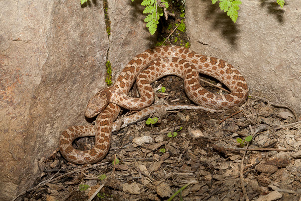
Desert Nightsnake ranges from Central America through southwestern North America (Figure 2), extending from Costa Rica in the south, throughout much of mainland Mexico and Baja California, north through the western United States to southern British Columbia (Gregory 2001). The deserticola subspecies is the only representative of Hypsiglena chlorophaea in Canada and occurs at the species’ northern range limit in southern British Columbia, extending south through central Washington and Oregon, to Mexico, excluding western California. The range extends eastward into southwestern Idaho, Nevada, Utah, Colorado and northwestern Arizona (Mulcahy 2007).
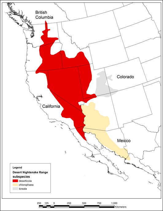
Long description for Figure 2
A map of western North America shows the range of three subspecies of Desert Nightsnake. The deserticola subspecies has a range extending from the northern tip of Baja-California in Mexico, north to British Columbia. This patch is contained inland from the Pacific Coast, and extends as far east as central Utah. In the northern part of this patch, the range narrows significantly north of central Oregon and Idaho and only a very small tip extends into the South of British Columbia. The chlorophaea subspecies extends from Sinaloa province in western Mexico, northwards to Arizona, Covering most of the western half of Arizona. The loreala subspecies occupies the smallest patch of the three subspecies, and is found mostly in southeastern Utah, with some of this range extending into northern Arizona, western Colorado, and northwest New Mexico.
In Canada, Desert Nightsnake is known only from British Columbia (Figure 3). It has been reported in the Okanagan Valley, south of Penticton to the United States border, and there is one record from the Lower Similkameen Valley. Nevertheless, the species is difficult to detect owing to its nocturnal and secretive nature; the current known distribution is based on limited data collected mainly by informal survey in the south Okanagan Valley. Similar habitats and sympatric reptile species occur outside of the known Desert Nightsnake range in the province, suggesting the range may be more extensive (Gregory 2001). For example, their main prey species, Western Skink (Plestiodon skiltonianus), occurs continuously on the east side of the Okanagan Valley to Kelowna (B.C. Western Skink Working Group 2013) about 40 km north of the nearest Desert Nightsnake record. Western Rattlesnakes, with which Desert Nightsnakes often hibernate communally, occur throughout most of the Okanagan Valley and in the Thompson-Nicola, Midway, and Grand Forks areas. The first sighting of a Desert Nightsnake in Canada was reported in 1980 and only 71 observations were reported between 1980 and 2015 at 18 sites (Sarell, pers. comm., 2016; Conservation Data Centre 2016). Eight of the known sites are on conservation lands (e.g., lands owned by The Nature Trust of British Columbia, Vaseux Bighorn National Wildlife Area, Haynes’ Lease Ecological Reserve).
This population occurs on federal and non-federal land. British Columbia is likely to have less than 1% of the global distribution and world population of Desert Nightsnake (Southern Interior Reptile and Amphibian Recovery Team 2013).
Accurate population estimates are not available for Desert Nightsnake in British Columbia. Gregory (2001) speculated that less than 200 adults are extant. COSEWIC (2011) suggested the population is small with perhaps fewer than 1000 adults. The B.C. Conservation Data Centre (2016) estimated 50–1000 individuals. No trend data is available, but population size and distribution are believed to be declining based on past and ongoing threats primarily attributed to habitat loss and road mortality (Southern Interior Reptile and Amphibian Recovery Team 2008; COSEWIC 2011).
Desert Nightsnake habitat in British Columbia is connected to modeled Desert Nightsnake habitat in Washington State; the nearest Desert Nightsnake record in Washington is approximately 20 km south of the United States border (Washington State Herp Atlas 2013). This suggests that potential exists for Desert Nightsnake population connectivity between British Columbia and Washington, with associated rescue effects. It is unknown whether connectivity to the adjacent Desert Nightsnake population in the United States is essential to its survival and recovery in Canada.
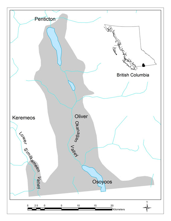
Long description for Figure 3
A map southern British Columbia shows that the range of the Desert Nighsnake occupies a river valley region stretching from Penticton, in the north, to Osoyoos in the south- including the Okanagan Valley in between. The range is around 25 Km wide for most of the length, and widens to around 45 Km as it extends south to the US border. Near the border, this also includes some of the Lower Similkameen Valley.
Little is known about the biological or habitat needs of the Desert Nightsnake in British Columbia owing to limited observations (Gregory 2001; COSEWIC 2011), likely a result of their nocturnal habits (Weaver 2010a). In Washington State, Weaver (2010a) reported 120 of 121 (99%) observations were at night and more often during periods of low moonlight. The secretive behaviour, demonstrated in studies elsewhere in North America, suggests that the Desert Nightsnake spends much of the time underground in talus, rodent burrows, or partly burrowed in their own excavations (Gregory 2001). Desert Nightsnake records in the province are limited to the Bunchgrass, Ponderosa Pine, and Interior Douglas-fir biogeoclimatic zones, mainly below 1000 m elevation (Southern Interior Reptile and Amphibian Recovery Team 2008; B.C. Conservation Data Centre 2016). The species is associated with talus, rock outcrops, sandy areas, shrubs, grassland, riparian areas, and dry forest (Lacey et al. 1996; Gregory 2001; Southern Interior Reptile and Amphibian Recovery Team 2008). To meet life requisites, habitat must include winter dens (hibernacula), foraging sites with suitable cover and prey densities, and egg-laying sites, all located close together (Southern Interior Reptile and Amphibian Recovery Team 2008).
Function: Denning (hibernation)
Little is known about Desert Nightsnake denning in British Columbia. Eighteen known or suspected den sites have been reported in the province (B.C. Conservation Data Centre 2016), but no summary of den site characteristics is available. Radke (1989) and Gregory (2001) suggested that Desert Nightsnakes likely use communal dens with Western Rattlesnake and other snake species; however, non-communal dens are also used (Sarell, pers. comm., 2016). Desert Nightsnake dens are mostly below 600 m elevation but can be up to 1000 m (Sarell, pers. comm., 2016). Den sites for Western Rattlesnake generally are on southeast to southwest aspects in cliff, talus, or rock outcrops with fissures or cracks that provide access below the frost line (COSEWIC 2015). Macartney et al. (1987) reported one Western Rattlesnake den was 3–5°C in winter and Hobbs (2007) reported an average minimum winter den temperature of 9.6°C. Humidity may also be important but research is lacking (Hobbs 2013).
Timing of den use is assumed to be similar to other snakes in southern British Columbia, from approximately October to March (Gregory 2001). The earliest spring record for Desert Nightsnake is April 1 and the latest records are on September 28 and October 12 (B.C. Conservation Data Centre 2016). Weaver (2010) found Desert Nightsnake in nearby central Washington State were active, in non-denning habitats, between April and October.
Tables 1 and present a summary of functions, features, and attributes for denning habitat.
| Life stage(s) | Functiona | Feature(s)b |
|---|---|---|
| All | Overwintering | Dens (hibernacula) |
a Function: a life-cycle process of the species (e.g., overwintering).
b Feature: the essential structural components of the habitat required by the species.
| Attributec | Description |
|---|---|
| Elevation | Mostly below 600 m elevation but can be up to about 1000 m elevation |
| Climate | Bunchgrass, Ponderosa Pine, Interior Douglas-fir biogeoclimatic zones in the south Okanagan and lower Similkameen valleys |
| Availability | September through March |
| Aspect | Mainly southwest to southeast aspects but may be found on other aspects |
| Structure | Cliff, talus, or rock outcrop with cracks or fissures that provide access below the frost line |
| Temperature | Stable minimum winter temperatures at or above approximately 3–9°C during the denning period |
| Humidity | Suitable humidity to prevent desiccation is likely important but details are unknown |
c Attribute: the building blocks or measurable characteristics of a feature.
Function: Foraging, migration, egg laying
Desert Nightsnakes emerge from dens in early April and move to foraging sites until September or October (Gregory 2001; Weaver 2010a; B.C. Conservation Data Centre 2016). Foraging and migration habitats overlap. No telemetry data are available to document movement distance away from dens for this species in British Columbia. The farthest distance a Desert Nightsnake has been found from the nearest known den is 400 m (B.C. Conservation Data Centre 2016). Hammerson (2013) suggested the application of a 500 m inferred minimum extent of habitat use, when the actual extent is unknown.
Desert Nightsnake is found in the Bunchgrass, Ponderosa Pine, and Interior Douglas-fir biogeoclimatic zones in rock, talus, shrub–steppe and open coniferous forest (B.C. Conservation Data Centre 2016). Diller and Wallace (1986) reported 31 of 41 (76%) Desert Nightsnake captures in Idaho were found in talus and canyon rim habitat, with the remainder in shrub–steppe. Desert Nightsnake were found under rocks in early spring but not in summer. Two snakes were found in rodent burrows. Weaver (2008) quantified habitat adjacent to 121 Desert Nightsnakes that were found on roads in Washington State. Ninety-five (78%) were associated with talus habitat, with and without vegetation. Other habitats included oak savannah–woodlands (10%), big sagebrush–rabbitbrush flats (7%), croplands (3%), grasslands (2%), and pine–fir forest (1%).
Only one confirmed prey record, a juvenile Western Rattlesnake, is known for Desert Nightsnake in the province (Lacey et al. 1996). Desert Nightsnake mainly eat lizards, lizard eggs, and occasionally frogs, other snakes, and insects (Gregory 2001). Rodriguez-Robles et al. 1999 reported 48 of 92 (52%) prey items were lizards and 21 (23%) were lizard eggs. Diller and Wallace (1986) found mostly lizard and lizard eggs (9 of 12 prey items), with one Great Basin Spadefoot (Spea intermontana) and two insects. In Central Washington, Weaver (2010b) found lizards (31 of 48; 65%) and lizard eggs (7 of 41; 15%) were the main prey items. Lizard species included Western Skink, which was the main prey species (21 of 48, 44%), Alligator Lizard (Elgaria sp.), Side-blotched Lizard (Uta stansburiana), and Western Fence Lizard (Sceloporus occidentalis). Weaver also found that 6 of 48 (13%) prey items were Garter Snake (Thamnophis sp.), 3 of 48 (6%) were anurans (Northern Pacific Treefrog [Pseudacris regilla] and Western Toad [Anaxyrus boreas]), and one was a mammal. Weaver and Kardong (2009) found Desert Nightsnake showed a preference for lizard odour and an aversion to mouse odour. In British Columbia, lizards, including Western Skink and Northern Alligator Lizard (Elgaria coerulea), are associated with rock and other cover objects (Matsuda et al. 2006), suggesting Nightsnakes are using talus areas for hunting their major prey species.
Snakes retreat to cover objects about 1 week before shedding because vision is impaired by an exudate between the old and new skin, making them more vulnerable to predators (Klauber 1997). Shed skins have been found under rocks in foraging habitat (Sarell, pers. comm., 2016).
Desert Nightsnake is oviparous (egg-laying) (Gregory 2001). One observation of mating was recorded on May 7 (Sarell, pers. comm., 2016); however, reproductive biology is not well known in British Columbia (Gregory 2001). In Washington State, Desert Nightsnake breeding occurred from May through June, egg-laying occurs from mid-June to early July, and hatching occurs in July (Weaver 2010a) and mid-August (Weaver 2010b). Thirty-eight percent of females (N = 17) were gravid, suggesting a triennial breeding cycle (Weaver 2010b). Clutch size ranges from two to seven eggs with an average of four (N = 6) (Werler 1951; Clark 1966; Lieb 1973; Diller and Wallace 1986). The age of sexual maturity appears to be unknown (Diller and Wallace 1986). Egg-laying habitats are not known for the Desert Nightsnake (Gregory 2001).
Tables 3 and 4 present a summary of functions, features, and attributes for foraging/migration habitat.
| Life stage(s) | Functiond | Feature(s)e |
|---|---|---|
| All | Foraging, migration, mating, egg-laying, incubation, shedding | Grassland, shrub–steppe, riparian, open ponderosa pine or Douglas-fir forest |
d Function: a life-cycle process of the species (e.g., foraging, migration, mating).
e Feature: the essential structural components of the habitat required by the species.
| Attributef | Description |
|---|---|
| Elevation | Mostly below 600 m elevation but can be up to about 1000 m |
| Climate | Bunchgrass, Ponderosa Pine, Interior Douglas-fir biogeoclimatic zones in the south Okanagan and lower Similkameen Valleys |
| Habitat | Talus, rock outcrops, and to a lesser degree grassland, shrub–steppe, open ponderosa pine and Douglas-fir forest |
| Availability | April through October |
| Distance from den | Unknown but estimated to be within ~500 m of den sites |
| Retreats | Talus, rock outcrops, large rocks, rock piles |
| Shedding retreats | Under rocks |
| Prey | Mainly lizards and their eggs but also includes other snakes, amphibians, and insects |
| Egg-laying sites | Unknown |
| Other | Low densities of housing, agriculture, roads and vehicle traffic, all of which increase potential for direct mortality and may cause barriers to movement |
f Attribute: the building blocks or measurable characteristics of a feature.
Function: Dispersal
Longer movements, outside of the species’ normal home range (about 500 m from the den), may occur across additional terrestrial habitat, allowing for colonization of new sites and/or between occupied sites. These occasional movements are not part of regular seasonal habitat use but are considered dispersal movements, and the additional terrestrial habitat required to meet this species’ need is termed “connectivity” habitat. Connectivity habitat is essential to support gene flow and long-term persistence of viable populations of snakes within the landscape.
Populations that are isolated and have limited genetic diversity can be more susceptible to disease and increased mortality owing to inbreeding depression (Clark et al. 2011). For example, Clark et al. (2011) documented that loss of connectivity resulted in genetic isolation, which contributed to physical abnormalities and disease, likely related to inbreeding depression, in a small population of Timber Rattlesnake (Crotalus horridus) in New Hampshire. Nothing is known about long-distance dispersal for this species. Hammerson (2013) suggested population separation distances of 1 km in unsuitable habitat (e.g., large lakes, fast rivers, densely urbanized areas, roads with barriers that prevent most crossings) and 10 km in suitable habitat are reasonable for Desert Nightsnake, based on other similar snake species in other areas. Research on this topic is needed. It is assumed that dispersal/connectivity habitat is similar to foraging habitat.
Tables 5 and 6 present a summary of functions, features, and attributes for dispersal/connectivity habitat.
| Life stage(s) | Functiong | Feature(s)h |
|---|---|---|
| All | Dispersal | Grassland, shrub–steppe, riparian, open ponderosa pine or Douglas-fir forest |
g Function: a life-cycle process of the species. (e.g., dispersal between sites and populations)
h Feature: the essential structural components of the habitat required by the species.
| Attributei | Description |
|---|---|
| Elevation | Mostly below 600 m elevation but can be up to about 1000 m |
| Climate | Bunchgrass, Ponderosa Pine, Interior Douglas-fir biogeoclimatic zones in the south Okanagan and lower Similkameen Valleys |
| Habitat | Talus, rock outcrops, and to a lesser degree shrub–steppe, open ponderosa pine and Douglas-fir forest |
| Availability | April through October |
| Distance from den | Unknown but estimated to be > 500 m (may be up to 1 km in unsuitable habitats and 10 km in suitable habitats); research is required |
| Retreats | Talus, rock outcrops, large rocks, rock piles |
| Shedding retreats | Under rocks |
| Prey | Mainly lizards and their eggs but also eat other snakes, amphibians, and insects |
| Egg-laying sites | Unknown |
| Other | Low densities of housing, agriculture, roads and vehicle traffic, all of which increase potential for direct mortality and may cause barriers to movement |
i Attribute: the building blocks or measurable characteristics of a feature.
Limiting factors are generally not human-induced and include characteristics that make the species less likely to respond to recovery/conservation efforts (e.g., inbreeding depression, long-lived species with low rate of reproduction, genetic isolation). Recovery of Desert Nightsnake populations likely is limited by several natural factors. These snakes require specialized winter dens that appear to be limited on the landscape. The aggregation of many individuals from one population makes them vulnerable to catastrophic events. The species has a low reproductive rate (two to seven young per female) and reproduction is infrequent (every 3 years) (Werler 1951; Clark 1966; Lieb 1973; Diller and Wallace 1986). Their limited motility (home range of ~ 500 m) implies that large dispersal distances between appropriate habitats may affect their ability to re-occupy extirpated habitats.
Threats are defined as the proximate activities or processes that have caused, are causing, or may cause in the future the destruction, degradation, and/or impairment of the entity being assessed (population, species, community, or ecosystem) in the area of interest (global, national, or subnational) (adapted from Salafsky et al. 2008). For purposes of threat assessment, only present and future threats are considered.Footnote1 Threats presented here do not include limiting factors,Footnote2 which are presented in Section 3.4.
The threat classification below is based on the IUCN–CMP (World Conservation Union–Conservation Measures Partnership) unified threats classification system and is consistent with methods used by the B.C. Conservation Data Centre. For a detailed description of the threat classification system, see the Open Standards website (Open Standards 2014). Threats may be observed, inferred, or projected to occur in the near term. Threats are characterized here in terms of scope, severity, and timing. Threat “impact” is calculated from scope and severity. For information on how the values are assigned, see Master et al. 2012 [PDF, 1.4 Mb]) and table footnotes for details. Threats for the Desert Nightsnake were assessed for the entire province (Table 7) in 2016 by Orville Dyer, Purnima Govindarajulu, Leah Ramsay, Mike Sarell, and Leah Westereng.
| Threat #j | Threat description | Impactk | Scopel | Severitym | Timingn |
|---|---|---|---|---|---|
| 1 | Residential and commercial development | Medium | Restricted | Serious | High |
| 1.1 | Housing and urban areas | Medium | Restricted | Serious | High |
| 1.2 | Commercial and industrial areas | Negligible | Negligible | Extreme | High |
| 1.3 | Tourism and recreation areas | Negligible | Negligible | Serious | High |
| 2 | Agriculture and aquaculture | Low | Large | Slight | High |
| 2.1 | Annual and perennial non-timber crops | Low | Small | Serious | High |
| 2.3 | Livestock farming and ranching | Low | Large | Slight | High |
| 3 | Energy production and mining | Low | Small | Extreme | High |
| 3.2 | Mining and quarrying | Low | Small | Extreme | High |
| 4 | Transportation and service corridors | Medium | Large | Moderate | High |
| 4.1 | Roads and railroads | Medium | Large | Moderate | High |
| 4.2 | Utility and service lines | Low | Small | Slight | High |
| 5 | Biological resource use | Unknown | Restricted | Unknown | High |
| 5.3 | Logging and wood harvesting | Unknown | Restricted | Unknown | High |
| 6 | Human intrusions and disturbance | Unknown | Restricted | Unknown | High |
| 6.1 | Recreational activities | Unknown | Restricted | Unknown | High |
| 7 | Natural system modifications | Low | Small | Slight | High |
| 7.1 | Fire and fire suppression | Low | Small | Slight | High |
| 8 | Invasive and other problematic species and genes | Low | Restricted | Slight | High |
| 8.1 | Invasive non-native/alien species | Low | Restricted | Slight | High |
| 10 | Geological events | Negligible | Negligible | Extreme–Serious | High |
| 10.3 | Avalanches/landslides | Negligible | Negligible | Extreme–Serious | High |
j Threat numbers are provided for Level 1 threats (i.e., whole numbers) and Level 2 threats (i.e., numbers with decimals).
k Impact – The degree to which a species is observed, inferred, or suspected to be directly or indirectly threatened in the area of interest. The impact of each threat is based on severity and scope rating and considers only present and future threats. Threat impact reflects a reduction of a species population. The median rate of population reduction for each combination of scope and severity corresponds to the following classes of threat impact: Very High (75% declines), High (40%), Medium (15%), and Low (3%). Unknown: used when impact cannot be determined (e.g., if values for either scope or severity are unknown); Not Calculated: impact not calculated as threat is outside the assessment time (e.g., timing is insignificant/negligible [past threat] or low [possible threat in long term]); Negligible: when scope or severity is negligible; Not a Threat: when severity is scored as neutral or potential benefit.
l Scope - Proportion of the species that can reasonably be expected to be affected by the threat within 10 years. Usually measured as a proportion of the species’ population in the area of interest. (Pervasive = 71–100%; Large = 31–70%; Restricted = 11–30%; Small = 1–10%; Negligible < 1%).
m Severity - Within the scope, the level of damage to the species from the threat that can reasonably be expected to be affected by the threat within a 10-year or 3-generation timeframe. For this species a generation time of 5 years was used, resulting in severity being scored over a 15-year time frame. Usually measured as the degree of reduction of the species’ population. (Extreme = 71–100%; Serious = 31–70%; Moderate = 11–30%; Slight = 1–10%; Negligible < 1%; Neutral or Potential Benefit ≥ 0%).
n Timing - High = continuing; Moderate = only in the future (could happen in the short term [< 10 years or 3 generations]) or now suspended (could come back in the short term); Low = only in the future (could happen in the long term) or now suspended (could come back in the long term); Insignificant/Negligible = only in the past and unlikely to return, or no direct effect but limiting.
The overall province-wide Threat Impact for this species is High. This overall threatFootnote3 considers the cumulative impacts of multiple threats. Details are discussed below under the Threat Level 1 headings. Note that threats that were determined to have a Negligible threat impact were kept in Table 7 for completeness but are not discussed in detail below.
Conversion of suitable habitat into residential areas affects all life stages by removing or altering dens or foraging habitat in talus and rock outcrop (COSEWIC 2011). Direct mortality can occur during excavation, blasting, or filling-in suitable habitat.
New agricultural development, mainly vineyards, can remove shrub–steppe habitat and create movement barriers that may limit connectivity between occupied sites (COSEWIC 2011), especially if these developments are adjacent to talus slopes. Agricultural development affects all life stages. The severity of agricultural impacts can be Serious at some sites, but the scope of impact is Small.
Livestock ranching occurs throughout the species’ range, but the severity of impacts from grazing on Desert Nightsnake populations is Slight, given the species’ affinity to areas not generally used by grazing cattle (e.g., talus). Nevertheless, cattle were observed to dislodge rock cover on steep slopes, where livestock use was high, causing rock retreat sites to be unsuitable as cover objects for Nightsnakes and their prey (Sarell, pers. comm., 2016).
No mine developments are expected within the Desert Nightsnake distribution in the near future, but quarrying of talus slopes may cause direct mortality, loss of prey, and loss of denning and foraging habitat. Site-specific severity can be Extreme and affect all life stages, although the scope is estimated to be Small.
Ongoing road mortality has a Medium impact because the scope is Large and the severity for affected populations is Moderate. Row et al. (2007) predicted that road mortality of more than three adult females per year in a stable population of approximately 400 Black Rat snakes in Ontario increased extinction probability from 7% to more than 90%. Road mortality was identified as the primary cause of local extinction of Timber Rattlesnake populations in eastern Texas (Rudolph et al. 1999). Rudolph et al. (1999) reported that populations of large snakes (e.g., Louisiana Pine Snake [Pituophis ruthveni]) within 450 m of a road could be reduced by more than 50%. Reed (2013) predicted a population reduction of up to 90% for Gopher Snake in the province over 24 years (three generations).
Roads occur throughout most of Desert Nightsnake’s limited range in British Columbia. At least three (4%) of the 71 Desert Nightsnakes found in the province were dead on roads (Sarell, pers. comm., 2016). Forty-seven (39%) of 121 Desert Nightsnakes found in nearby Washington Snake were dead on roads with low (50–100 vehicles per day) traffic volumes (Weaver 2010a). Roads affect all life stages, except eggs, through direct mortality and fragmentation of populations.
The impact from utility and service lines is thought to be Low, owing to low traffic volumes and maintenance, contributing to a Slight severity with a Small scope.
Impacts from hunting and collecting may occur but are not believed to be a threat to this species. Low-elevation logging does occur in parts of Desert Nightsnake distribution, although the severity and impact of this threat are Unknown.
Impacts from activities such as hiking, off-road vehicle use, and mountain biking on Desert Nightsnake have not been researched. The scope is Restricted, owing to the species association with talus habitats and the severity of the impact is Unknown.
Over time, fire suppression can alter grassland and forest habitat structure owing to forest encroachment, which may alter thermal conditions and affect prey abundance (B.C. Western Skink Working Group 2013). Fuel build-up, resulting from historic fire suppression activities, can lead to very hot, fast-moving wildfires that may be inescapable for snakes. Fireguards constructed during active fire suppression can also result in accidental mortality as well as habitat loss and den destruction. This threat can affect all life stages, but severity is Slight and scope is Small, resulting in a Low impact.
Loss et al. (2013) estimated that 258–822 million reptiles could be killed annually by cats in the United States. One of 14 Desert Nightsnakes reported by Lacey et al. (1996) in the province had been partially eaten by a cat. The severity of cat predation on Desert Nightsnake is thought to be Slight and the scope is Restricted.
Snakes are susceptible to fungal diseases. Ophidiomyces ophiodiicola is a fungus that to date has only been detected among rattlesnake populations in the eastern United States (Allender et al. 2011). This disease can cause high mortality in snakes that are infected. Although this fungus is unknown in British Columbia, this is an emerging issue that could be particularly devastating, if the fungus spreads. This threat requires monitoring.
Raccoon (Procyon lotor) and Common Raven (Corvus corax) are potentially problematic native species that may eat Desert Nightsnake. They have expanded their ranges and numbers in the province (Hatler et al. 2008; Environment Canada 2015); however, their impact on Desert Nightsnake is Unknown.
Desert Nightsnake may be vulnerable to avalanches or landslides mainly at rock and talus dens. Slopes and hillsides may be susceptible to washouts and slope failures, causing direct mortality and loss of important habitat features such as dens. The impact on snake populations could be Extreme at some sites, particularly if dens are destroyed and large numbers of snakes are killed. As an example, a hillside slump in Grassland National Park caused up to 90% mortality of hibernating snakes (Hobbs, pers. comm., 2016). In British Columbia, slumping related to heavy rain has been observed in snake habitat, but no data exist to quantify the effects on snakes (Sarell, pers. comm., 2016). The impact is thought to be Negligible owing to a limited scope in British Columbia
The recovery goal is to maintain or increase the abundance of Desert Nightsnake within its known geographic range in British Columbia and to maintain or increase connectivity within and between occupied areas.
The Desert Nightsnake has a restricted distribution in British Columbia, where it relies mainly on talus and rock features in a fragmented landscape (Gregory 2001). Primary threats include direct harm from road mortality and habitat loss from housing development. Lower-ranked threats include habitat loss or degradation from agriculture, quarrying, and fire suppression, and direct harm from invasive non-native species. Desert Nightsnake habitat in British Columbia is connected to modeled Desert Nightsnake habitat in Washington State; the nearest Desert Nightsnake record in Washington is approximately 20 km south of the United States border (Washington State Herp Atlas 2013). This suggests that potential exists for Desert Nightsnake population connectivity between British Columbia and Washington, with associated rescue effects, so maintaining this connectivity may be important. Knowledge gaps related to inventory, habitat suitability, and population trends preclude development of quantitative population and habitat targets.
The species was designated by COSEWIC as Endangered under criteria B1ab(iii) + B2ab(iii) (COSEWIC 2011). B1ab(iii) means an extent of occurrence of less than 5000 km2, a severely fragmented population, and a continuing decline (observed, inferred, or projected) in area, extent, and/or quality of habitat. B2ab(iii) means an index or area of occupancy of less than 500 km2 , a severely fragmented population, and a continuing decline (observed, inferred, or projected) in area, extent, and/or quality of habitat.
Improving the species’ condition may be possible in the future, provided that threats to the habitat and populations can be substantially reduced and habitat connectivity increased, so populations remain viable over the long term. Increasing connectivity among sites (e.g., by restoring or protecting habitat in the intervening areas and/or facilitating safe movements across roads) could be used to reduce fragmentation and maintain a “rescue effect” between populations.
The immediate recovery objectives are to reduce mortality from roads and prevent further loss and fragmentation of the species’ distribution range. More information about population sizes and trends across the landscape and opportunities to mitigate threats is needed to quantify an appropriate long-term recovery goal for this species. In the short term, if additional naturally occurring populations are discovered, they should be maintained. Restoring and protecting dispersal habitat lost from human-induced fragmentation is important for maintaining viable populations within its distribution area in British Columbia.
Sufficient information to quantify long-term population and habitat targets is not available for Desert Nightsnake. The following objectives are necessary to meet the recovery goal and facilitate species recovery.
- Identify new den (hibernation) sites, secure occupied sites, and ensure connectivity is maintained between foraging/migration, shedding, and dispersal habitats throughout the species’ known range in British Columbia.
- Reduce road mortality to a level that will not affect population viability.
- Address knowledge gaps related to population demography, habitat quality, distribution, and use and to improve understanding of threats and increase effectiveness of recovery actions.
Secure habitat is defined as Desert Nightsnake habitat that is managed to maintain the species for a minimum of 100 years. It includes suitably connected hibernation (denning), foraging, shedding, and dispersal habitat where threats are addressed. Habitat securement will require a stewardship approach that engages the voluntary cooperation of landowners and managers on various land tenures to protect this species and the habitat upon which it relies. It may include stewardship agreements, conservation covenants, ecological gifts, voluntary sale of private lands by willing landowners, land use designations, protected areas, management agreements, and existing legislation. Addressing knowledge gaps in relation to distribution and habitat use is important for identifying sites for securement.
The following actions have been categorized by the action groups of the B.C. Conservation Framework (B.C. Ministry of Environment 2009). Status of the action group for this species is given in parentheses.
- COSEWIC report completed (Gregory 2001; COSEWIC 2011).
- Desert Nightsnake assessed as Endangered (Gregory 2001; COSEWIC 2011).
- Provincial Recovery Plan (2008; this document 2016).
- Monitor Trends (in progress)
- Opportunistic monitoring of rock den sites ongoing (Hobbs 2013) but requires additional attention and a stronger focus on Desert Nightsnake.
- Inventory to identify sites for protection included den searches for Western Rattlesnakes (see summary in Hobbs 2013), reporting of incidental sightings through Wildlife Species Inventory (B.C. Ministry of Environment 2016), identified wildlife surveys, and targeted environmental assessments (e.g., Sarell 2007); however, recent inventory has been limited and opportunistic. Specific focus on Desert Nightsnake is needed.
- Eight of the known sites are on conservation lands (e.g., lands owned by The Nature Trust of British Columbia, Vaseux Bighorn National Wildlife Area, Haynes’ Lease Ecological Reserve, McTaggart-Cowan/nsk’niw’t Wildlife Management Area).
- One wildlife habitat area (336 ha) for other snake species was established under the Forest and Range Practices Act Identified Wildlife Management Strategy (IWMS) and will benefit Desert Nightsnake since they use similar habitats. Desert Nightsnake is not listed as an Identified Wildlife Species.
- Private land conservancies have protected habitat: The Nature Trust of British Columbia’s Okanagan Falls Biodiversity Ranch, Skaha Eastside, Emery, and Antelope-brush properties, Southern Interior Land Trust S.L.15).
- The Okanagan Similkameen Stewardship Society (2016) includes Desert Nightsnake in public information and landowner contact programs.
- South Okanagan–Similkameen Conservation Program and Okanagan Collaborative Conservation Program completed Keeping Nature in our Future, a biodiversity strategy for the Okanagan (South Okanagan–Similkameen Conservation Program 2012). The strategy includes detailed conservation ranking maps, analyses by local government area, and recommendations for environmentally sensitive development permit areas (White, pers. comm., 2016). A companion document on designing and implementing ecosystem connectivity in the Okanagan was produced (Latimer and Peatt 2014).
- Guidelines for Amphibian and Reptile Conservation during Urban and Rural Land Development in British Columbia were updated (Province of British Columbia 2014).
- Best Management Practices for Amphibian and Reptile Salvages in British Columbia were developed (B.C. Ministry of Forests, Lands and Natural Resource Operations 2016).
- The “Snake Smart” program conducted outreach and training to help protect snakes from persecution through information, training, and support in four languages in south Okanagan vineyards (Okanagan Similkameen Conservation Program 2016).
| Objective | Conservation Framework action group | Actions to meet objectives | Threato or concern addressed | Priorityp |
|---|---|---|---|---|
| 1, 2, 3 | Monitor Trends | Develop and implement a strategic plan to monitor selected dens and populations with greater frequency and intensity that will provide statistically reliable trends, especially at sites with higher risk of habitat loss and road mortality threats. Include Desert Nightsnake in monitoring of current Western Rattlesnake population, habitat, and threat trends at the Nk’mip site at Osoyoos. | 1.1, 1.2, 2.1, 2.3, 4.1 | Essential |
| 1, 2, 3 | Monitor Trends | Develop and implement a strategic approach to quantitatively monitor road mortality at several sites across the species’ range with suitable frequency and intensity over a long term, with other snake species. | 4.1 | Essential |
| 1, 2, 3 | Monitor Trends | Continue to opportunistically monitor for presence and develop new, intensive, and longer-term monitoring sites in other parts of the range by implementing the strategic plan (mentioned above). | 1.1, 1.2, 2.3, 4.1 | Essential |
| 1, 2 | Habitat protection | Inventory potential sites and record incidental sightings to identify sites for habitat protection and to clarify distribution. | 1.1, 1.2, 2.1, 2.3, 4.1, 6.1 | Essential |
| 1, 2 | Habitat protection | Clarify potential connectivity/dispersal habitat using habitat mapping and improve connectivity at priority sites (requires identification) and potential rescue populations in the United States. Increase safety of connectivity habitat by reducing road mortality and movement barriers. | 1.1, 1.2, 2.1, 2.3, 4.1, 6.1 | Essential |
| 1, 2 | Habitat protection | Continue to improve habitat protection through existing land use designations and management agreements on Crown land (e.g., protected areas, wildlife habitat areas, Land Act reserves, range use plans). Note that wildlife habitat areas can use Western Rattlesnake as a surrogate species unless Desert Nightsnake becomes listed as Identified Wildlife. | 1.1, 1.2, 2.1, 2.3, 4.16.1 | Essential |
| 1, 2 | Habitat protection | Continue working with First Nations to identify and implement opportunities for cooperative habitat conservation projects both on and off reserve land. Incorporate traditional ecological knowledge into recovery actions. | 1.1, 1.2, 2.1, 2.3, 4.1, 6.1 | Essential |
| 1, 2 | Habitat protection | Continue to work with local governments to incorporate habitat stewardship and protection into planning processes such as official community plans, environmentally sensitive development permit areas, zoning, bylaws, and park/recreation plans (e.g., South Okanagan Similkameen Conservation Program, Regional District of Okanagan Similkameen biodiversity strategy implementation). | 1.1, 1.2, 2.1, 2.3, 4.1, 6.1 | Essential |
| 1, 2 | Habitat protection | Minimize impacts from fire suppression by developing and implementing best practices. | 7.1 | Beneficial |
| 1, 2 | Private land stewardship | Continue to acquire and manage important habitat through purchase of private lands from willing vendors (e.g., acquisitions by The Nature Trust of British Columbia; The Nature Conservancy of Canada; Southern Interior Land Trust). | 1.1, 1.2, 2.1, 2.3, 4.1, 6.1 | Essential |
| 1, 2 | Private land stewardship | Implement stewardship agreements, conservation covenants, and best management practices on private lands through voluntary agreements (e.g., Okanagan Similkameen Stewardship Society and local government stewardship agreements). | 1.1, 1.2, 2.1, 2.3, 4.1, 6.1 | Necessary |
| 1, 2 | Habitat restoration | Identify “hot spots” where a high level of road mortality occurs and implement mitigation (e.g., fencing with underpasses), if required; use research and adaptive management to identify effective actions to reduce or eliminate mortality and restore connectivity habitat, in cooperation with the Ministry of Transportation and Infrastructure. | 4.1 | Essential |
| 1, 2 | Habitat restoration | Identify and strategically reduce movement barriers in terrestrial habitat where loss of habitat and connectivity is seriously affecting population viability. | 1.1, 1.2, 2.1, 2.3, 4.1, 6.1 | Necessary |
| 1, 2, 3 | Species and population management | Develop and initiate a prioritized research strategy to address biological knowledge gaps (regarding distribution, movements, population structure, metapopulation dynamics, prey relationships, genetic and landscape connectivity), clarify threats, and improve effectiveness of recovery actions in collaboration with academia. Consider harmonic direction finder systems, cover objects, and genetic approaches to clarifying habitat use and connectivity. | 1.1, 2.1, 2.3, 4.1, 6.1, 7.1, 8.1, 11 | Essential |
| 1, 2, 3 | Species and population management | Develop and implement long-term research projects at several sites within the species’ range to clarify road mortality issues, associated population impacts, and effective mitigation options for existing and future roads, in collaboration with the Ministry of Transportation and Infrastructure and academia. | 4.1 | Essential |
| 1, 2, 3 | Species and population management | Continue to develop and deliver outreach materials to priority target audiences to increase understanding, support for and implementation of all recovery actions in collaboration with local stewardship groups. | 1.1, 2.1, 2.3, 4.1, 6.1, 7.1, 8.1, | Essential |
| 1, 2, 3 | Species and population management | Develop a population viability analysis to quantify population and habitat targets required for recovery, by area, and clarify long-term population impacts from road mortality associated with a range of road types and traffic densities. | 1.1, 2.1, 2.3, 4.1, 6.1, 7.1, 8.1, | Necessary |
| 1, 2, 3 | Species and population management | Monitor for emerging infectious diseases (e.g., Snake Fungal Disease) and contain their spread, if identified. | 8.1 | Necessary |
| 1, 2, 3 | Species and population management | Clarify potential impacts from livestock; identify mitigation measures, and implement priority actions. | 2.3 | Beneficial |
o Threat numbers according to the IUCN–CMP classification (see Table 7 for details).
p Essential (urgent and important, needs to start immediately); Necessary (important but not urgent, action can start in 2–5 years); or Beneficial (action is beneficial and could start at any time that was feasible).
The recovery activities in Table 8 will be accomplished using a broad, landscape conservation approach to maintain secure core habitats and connectivity, mainly through provincial Crown land designations and partnerships with local governments and non-government groups. An ecosystem approach (ecological communities or groups of similar ecological communities) will be used to protect and manage habitat for multiple species. Species at risk with overlapping habitat include the Western Rattlesnake, Gopher Snake, North American Racer, Rubber Boa (Charina bottae), and Western Skink. Recommended actions have been categorized by the action groups of the B.C. Conservation Framework.
The Nk’mip Desert Cultural Centre at Osoyoos has conducted annual mark/recapture and other monitoring for Western Rattlesnake and Gopher Snake but has not been able to include Desert Nightsnake. This type of long-term trend monitoring is seldom available for any species, yet it is invaluable for quantifying population numbers, habitat use, and impacts of threats. It is important to continue monitoring and associated research at this site and include Desert Nightsnake, and replicate this research in other areas where climate and threats are different. Lower-intensity monitoring also will be helpful at selected sites.
Monitoring for disease (e.g., Snake Fungal Disease) needs to be established, including clear baseline data.
Despite substantial inventory to identify sites for protection, many rock dens have not been identified and the historic and current ranges are not completely known. It is important to identify the complete distribution of this species in British Columbia to aid in habitat protection planning. Some specific areas for inventory at the edges of the current range include the Naramata area, the Gilpin area, lower Similkameen valley, Osoyoos West Bench extending north to Oliver Mountain, and the Yellow Lake corridor between Okanagan and Similkameen.
Habitat protection is needed to provide core areas that have low threat levels and can support viable populations in the long term. Without secure habitat, the species will continue to be at risk. Provincial conservation land designations (e.g., parks, wildlife management areas) and partnerships with land conservancies such as The Nature Trust, The Nature Conservancy of Canada, and the Southern Interior Land Trust have been very important for securing Desert Nightsnake habitat. There is a need to encourage and support voluntary stewardship by landowners and managers on all land tenures (i.e., private, commercial, Crown) to make recovery activities successful.
Vehicle-caused mortality is a serious threat to snakes in general. The issue is poorly quantified and, to date, very little has been done in the province to address it. A substantial and sustained approach to reducing road kill to sustainable levels is needed to provide effective protection on conservation lands, since snakes often move outside of conservation land boundaries and cross roads.
In addition, protected habitats must be linked by secure connectivity habitat to maintain gene flow and populations in the long term. These areas require identification and protection.
Targeted outreach activities must be sustained to inform landowners, land managers, and other stakeholders, and to encourage stewards to implement recovery actions.
No research on fine-scale habitat use, egg-laying, or movement is available for Desert Nightsnake in British Columbia. This is likely related to the snake’s small size, negating the use of standard telemetry techniques. These techniques require relatively large transmitters that are too large for use on this species. This hampers recovery activities. Alternate approaches such as cover boards and the harmonic direction finder system used on the similar-sized Sharp-tailed Snake (Contia tenuis) (Engelstoft et al. 1999) should be investigated. Dorsal pattern recognition can be used to identify individuals (Sarell, pers. comm., 2016). Genetic approaches to assessing population size, connectivity, and population impacts should also be considered.
Development of a research strategy will help to prioritize research topics and encourage a sustained approach to address knowledge gaps and evaluate recovery actions. Basic biology and habitat use data is required to support most research needs. For example, research to address knowledge gaps related to microhabitat use (e.g., dens, movement, egg-laying), road mortality, and effective mitigation approaches should be initiated as soon as possible. Population viability analysis is needed to clarify status, prioritize impacts for management action, and communicate issues to managers. Detailed, long-term population demography and mortality data is needed to develop viability models. Unknowns related to climate change, livestock impacts, and disease need to be addressed so pro-active responses can be developed.
Survival/recovery habitat is defined as the habitat that is necessary for the survival or recovery of the species. This is the area in which the species naturally occurs or depends on directly or indirectly to carry out its life-cycle processes, or formerly occurred on and has the potential to be re-introduced (see Section 3.3)
A description of the known biophysical features and their attributes of the species’ habitat that are required to support its life-cycle processes (functions) are provided in Section 3.3. Little is known about the biological or habitat needs of the Desert Nightsnake in British Columbia because limited observations have been made. An improved understanding of this species’ ecology would facilitate more effective conservation of their habitats and ensure measures to promote and/or maintain connectivity between hibernacula and core foraging areas are effective. Additional work required to address habitat knowledge gaps is included in the Recovery Action Table (Table 8).
The area of survival/recovery habitat required for a species is guided by the amount of habitat needed to meet the recovery goal. Although no fine-scale habitat maps are included with this document, it is recommended that the locations of survival/recovery habitat be described on the landscape to mitigate habitat threats and to facilitate the actions for meeting the recovery (population and distribution) goals.
The performance indicators presented below provide a way to define and measure progress toward achieving the recovery (population and distribution) goal.
- Desert Nightsnake population size is maintained or increased within the species’ known geographic range in British Columbia.
- Habitat connectivity is maintained or increased within and between occupied areas.
Performance measures toward meeting each of the three recovery objectives are as follows:
- Road mortality is reduced to a level that will not affect population viability at high priority sites.
- Additional hibernation (denning) sites and associated foraging, connectivity, and egg-laying habitats are secured throughout the species’ known range in British Columbia.
- A prioritized research strategy, including research on effectiveness of recovery actions, is developed and initiated.
Habitat protection, stewardship, inventory, and research activities for Desert Nightsnake are expected to benefit other species at risk that share its habitat including: Western Rattlesnake, Gopher Snake (deserticola subspecies), North American Racer, and Rubber Boa. Potential impacts on prey species such as the Western Skink are likely to be minimal and are part of natural ecosystem processes. The results of recovery actions targeted for Desert Nightsnake should provide ecosystem benefits to species in general that also occupy grassland and shrub–steppe habitats.
Allender, M.C., M, Dreslik, S. Wylie, C. Phillips, D.B. Wylie, C. Maddox, M.A. Delaney, and M.J. Kinsel. 2011. Chrysosporium sp. infection in eastern Massasauga rattlesnakes. Emerg. Infect. Dis. 17:2383–2384.
B.C. Conservation Data Centre. 2016. Conservation status report: Hypsiglena chlorophaea. B.C. Min. Environ., Victoria, BC. [Accessed May 27, 2016]
B.C. Ministry of Environment. 2009. Conservation framework–Conservation priorities for species and ecosystems: primer [PDF, 949 Ko]. Ecosystems Br., Environ. Stewardship Div., Victoria, BC. [Accessed May, 25, 2016]
B.C. Ministry of Environment. 2016. Wildlife species inventory database. [Accessed September 30, 2016]
B.C. Ministry of Forests, Lands and Natural Resource Operations. 2016. Best management practices for amphibian and reptile salvages in British Columbia. Victoria, BC. [Accessed September 28, 2016]
B.C. Western Skink Working Group. 2013. Management plan for the Western Skink (Plestiodon skiltonianus) in British Columbia. Prepared for the B.C. Ministry of Environment, Victoria, BC. [Accessed June 24, 2016]
Clark, D.R. 1966. Notes on sexual dimorphism in tail length in American snakes. Trans. Kansas Acad. Sci. 69:226–232.
Clark, R., M. Marchand, B. Clifford, R. Stechert, and S. Stephens. 2011. Decline of an isolated timber rattlesnake (Crotalus horridus) population: Interactions between climate change, disease, and loss of genetic diversity. Biological Conservation 144(2) 886-891.
Committee on the Status of Endangered Wildlife in Canada (COSEWIC). 2011. COSEWIC status appraisal summary on the Desert Nightsnake Hypsiglena chlorophaea in Canada [PDF, 315 Ko]. Ottawa, ON. [Accessed September 29, 2016]
Committee on the Status of Endangered Wildlife in Canada (COSEWIC). 2015. COSEWIC assessment and status report on the Western Rattlesnake Crotalus oreganus in Canada [PDF, 1.01 Mo]. Ottawa, ON. [Accessed April 21, 2016]
Diller, L.V. and R.L. Wallace. 1986. Aspects of the life history and ecology of the desert night snake, Hypsiglena torquata deserticola: Colubridae, in southwestern Idaho. Southwest. Nat. 31(1):55–64.
Dixon, J.R. and R.H. Dean. 1986. Status of the southern populations of the Night Snake (Hypsiglena: Colubridae) exclusive of California and Baja California. Southwest. Nat. 31:307–318.
Engelstoft, C., K. Ovaska, and N. Honkanen. 1999. The harmonic direction finder: a new method for tracking movements of small snakes. Herpetol. Rev. 30:84–87.
Environment Canada. 2015. North American breeding bird survey: Canadian trends website, data-version 2012. Environment Canada, Gatineau, QC. [Accessed February 23, 2015]
Government of Canada. 2002. Species at Risk Act [S.C. 2002] c. 29. [Accessed September 22, 2016]
Gregory, L. 2001. COSEWIC status report on the night snake Hypsiglena torquata in Canada. In COSEWIC assessment and status report on the night snake Hypsiglena torquata in Canada [PDF, 586 Ko]. Committee on the Status of Endangered Wildlife in Canada. Ottawa, ON. [Accessed September 29, 2016]
Hammerson, G. 2013. Population/occurrence delineation for medium to large Colubrid snakes. In NatureServe Explorer: An online encyclopedia of life [web application]. NatureServe, Arlington, VA. [Accessed June 7, 2016]
Hatler, D.F., D.W. Nagorsen, and A.M. Beal. 2008. Carnivores of British Columbia. Royal BC Museum Handbook, Victoria, BC.
Hobbs, J. 2007. Thermal factors in relation to the denning ecology of northern Pacific rattlesnakes in British Columbia. MSc thesis, Royal Roads University, Victoria, BC.
Hobbs, J. 2013. Species account and population assessment for the Western Rattlesnake in Canada. [Accessed February 17, 2015]
Klauber, L.M. 1997. Rattlesnakes: their habits, life histories, and influence on mankind. 2nd Ed. University of California Press, Oakland, CA.
Lacey, H., C.H. Shewchuk, P.T. Gregory, M.J. Sarell, and L.A. Gregory. 1996. The occurrence of the Night Snake, Hypsiglena torquata, in British Columbia, with comments on its body size and diet. Can. Field Nat. 110(4):620–625.
Latimer, S. and A. Peatt. 2014. Designing and implementing ecosystem connectivity in the Okanagan. Prepared for the Okanagan Collaborative Conservation Program, Kelowna, BC. [Accessed January 2016]
Lieb, C.S. 1973. Notes on reproduction in the Night Snake (Hypsiglena torquata). Southwest. Nat. 18:248–252.
Loss, S.R., T. Will, and P.P. Marra. 2013. The impact of free-ranging domestic cats on wildlife of the United States. Nature Comm. 4: article #1396.
Macartney, J.M., K.W. Larsen, and P.T. Gregory. 1987. Body temperatures and movements of hibernating snakes (Crotalus and Thamnophis) and thermal gradients of natural hibernacula. Can. J. Zool. 67:108–114.
Master, L.L., D. Faber-Langendoen, R. Bittman, G.A. Hammerson, B. Heidel, L. Ramsay, K. Snow, A. Teucher, and A. Tomaino. 2012. NatureServe conservation status assessments: factors for evaluating species and ecosystems at risk [PDF, 2.05 Mo]. NatureServe, Arlington, VA. [Accessed June 26, 2016]
Matsuda, B.M., D.M. Green, and P.M. Gregory. 2006. Amphibians and reptiles of British Columbia. Royal British Columbia Museum, Victoria, British Columbia. 288 p.
Mulcahy, D. 2007. Phylogeography and species boundaries of the western North American Nightsnake (Hypsiglena torquata): Revisiting the subspecies concept. Molecular Phylogenetics and Evolution. 46:1095-1115.
NatureServe. 2016. NatureServe explorer: an online encyclopedia of life [web application]. Ver. 7.1. NatureServe, Arlington, VA. [Accessed September 29, 2016]
Okanagan Similkameen Conservation Alliance. 2016. Snake Smart. Penticton. BC. [Accessed April 25, 2016]
Okanagan Similkameen Stewardship Society. 2016. [Accessed June 20, 2016]
Okanagan Valley Economic Development Society. 2013. 2013 economic profile: Okanagan Valley. [Accessed February 18, 2015]
Province of British Columbia. 1982. Wildlife Act [RSBC 1996] c. 488. Queen’s Printer, Victoria, BC. [Accessed September 22, 2016]
Province of British Columbia. 2002. Forest and Range Practices Act [RSBC 2002] c. 69. Queen’s Printer, Victoria, BC. [Accessed October 28, 2014]
Province of British Columbia. 2004. Identified wildlife management strategy. B.C. Min. Environ., Victoria, BC. [Accessed October 28, 2014]
Province of British Columbia. 2008. Oil and Gas Activities Act [SBC 2008] c. 36. Queen’s Printer, Victoria, BC. [Accessed October 28, 2014]
Province of British Columbia. 2014. Guidelines for amphibian and reptile conservation during urban and rural land development in British Columbia (2014) [PDF, 48.1 Mo]. Victoria, BC. [Accessed September 28, 2016]
Radke, W.R. 1989. Ecology of the Northern Pacific Rattlesnake on Columbia NWR: 1989 progress report. Wash. State Fish and Wildlife Serv., Othello, WA.
Rodriguez-Robles, J., D. Mulcahy and H. Greene. 1999. Feeding Ecology of the Desert Nightsnake, Hypsiglena torquata (Colubridae). Copeia, Vol. 1999, 1:93-100.
Row, J.R., G. Blouin-Demers, and P.J. Weatherhead. 2007. Demographic effects of road mortality in black ratsnakes (Elaphe obsolete). Biol. Conserv. 137:117–124.
Rudolph, D.C., S.J. Burgdort, R.N. Conner, and R.R. Schaefer. 1999. Preliminary evaluation of the impact of roads and associated vehicular traffic on snake populations in eastern Texas. In Proc. Int. Conf. Wildlife Ecology and Transportation. G.L. Evink, P. Garrett, D. Zeigler, and J. Berry (eds.). Florida Dep. Transportation, Tallahassee, FL. pp 129–136.
Salafsky, N., D. Salzer, A.J. Stattersfield, C. Hilton-Taylor, R. Neugarten, S.H.M. Butchart, B. Collen, N. Cox, L.L. Master, S. O’Connor, and D. Wilkie. 2008. A standard lexicon for biodiversity conservation: unified classifications of threats and actions. Conserv. Biol. 22:897–911.
Sarell, M. 2007. Rare reptile surveys in the South Okanagan and Lower Similkameen. Prepared for the Okanagan Region Wildlife Heritage Fund Society, and B.C. Ministry of Environment and Ministry of Transportation and Highways.
South Okanagan Similkameen Conservation Program. 2012. Keeping nature in our future: a biodiversity conservation strategy for the South Okanagan Similkameen. Penticton, BC. [Accessed September 28, 2016]
Southern Interior Reptile and Amphibian Recovery Team. 2008. Recovery strategy for the Night Snake (Hypsiglena torquata) in British Columbia. B.C. Min. Environ., Victoria, BC.
Washington Herp Atlas. 2013. Night Snake [webpage]. Washington Natural Heritage Program, Washington Dep. Fish Wildlife, U.S. Dep. Interior, Bur. Land Manage., and U.S. For. Serv., Olympia, Wash. [Accessed August 2016]
Weaver, R.E. 2008. Distribution abundance and habitat associations of Hypsiglena chlorophaea in Washington State. Northwest. Nat. 89:164–170.
Weaver, R.E. 2010a. Activity patterns of the Desert Nightsnake (Hypsiglena chlorophaea). Southwest. Nat. 55(2):172–178.
Weaver, R.E. 2010b. Diet and reproductive ecology of the Desert Nightsnake (Hypsiglena chlorophaea) in Central Washington State. J. Herpetol. 44(1):148–152.
Weaver, R.E. and K. Kardong. 2009. Microhabitat and prey odor selection in Hypsiglena chorophaea. Copeia 3:475-482.
Werler, J.E. 1951. Miscellaneous notes on the eggs and young of Texan and Mexican reptiles. Zoologica 36:37–48.
Williams, K.E., K.E. Hodges, and C.A. Bishop. 2014. Phenology and demography of Great Basin Gophersnakes (Pituophis catenifer deserticola) at the northern edge of their range. Herpetol. Conserv. Biol. 9(2):246–256.
Hobbs, J. Consultant, Victoria, BC.
Sarell, M. Consultant, Oliver, BC.
White, B. South Okanagan Similkameen Conservation Program Manager, Penticton, BC.