
Canada’s top 10 weather stories of 2023
David Phillips, senior climatologist, has compiled this year-end list following an examination of significant weather events in Canada.
He has selected these stories based on factors including the degree to which Canada was impacted, the extent of the area affected, economic and environmental effects and the event’s longevity as a top news story in Canada and around the world.
Introduction
The degree of devastation across Canada in 2023 was difficult to comprehend. It was not a pretty picture given countless scenes of charred landscapes, scorched shells of former homes, and debris piles as evidence of powerful tempests, dried out riverbeds, and fields underwater as far as you could see. Beautiful sunrises and sunsets belied the hazy yellow-orange sky that you often could smell and taste - not the pristine, fresh air that is so much part of the Canadian environment. It was hard for the world to believe that such smoky skies could emanate from Canada. Across the country, more than ¼ million Canadians had their lives upended by fires and floods and some on two or three occasions. Even worse, lives were taken and many more lost their livelihoods, homes and possessions. Nearly 90% of the Alert Ready warnings issued in 2023 came from wildfire and weather hazards.
The extremes we saw in 2023 were devastating in many ways, but this is what climate change looks and feels like. What we saw this year only serves as a preview of what the future could bring if emissions of greenhouse gases are not rapidly curtailed. As the climate continues to warm, one can expect increasing wildfires, more intense droughts and hurricanes, and more intense heat waves.
Not in 28 years of Top Ten Weather Events has there been a more obvious number one story than Record wildfires in 2023. In fact, it could have represented four stories in one this year: record area burned, continuation of multi-year drought, torrid heat and foul smoky skies for months on end. At times, out-of-control fires burned in nearly every province and territory. It was a story that captured international attention for much of the year. Fighting wildfires across Canada was a national preoccupation over three seasons, not the usual summer-long activity. In the end, 2023 was the worst wildfire year on record - at least twice the previous worst year and seven times the 10-year average of forests consumed by fires. Entire cities and several Indigenous communities were emptied by the threat of wildfires. Unbelievably, the area burned by wildfires stretched over 18 million hectares. One expert said that more than half the countries in the world could fit their geography into the total area burned this year in Canada.
The Earth’s average temperature this summer was one for the record books. Moreover, 2023 is very likely to be the warmest year in possibly 125,000 years. For Canada, it was the warmest summer in 76 years, dating back to the start of national record-keeping in 1948. Even more noteworthy, if you include May and September, each province and territory recorded their warmest five months on record, with the exception of Atlantic Canada. Warm coastal waters resulted in the hottest ever marine heat wave in Canadian waters. Parts of the Prairie Provinces went from slush in late April to sweat in early May practically making spring a no-show. In Eastern Canada, it was the longest “hot season” on record with days above 30°C for the first time in April and October.
In late January and February, a lobe of the polar vortex dipped southward pushing from the North to West to East. Across the West, temperatures averaged 5 to 15 degrees colder than normal for some of the lowest temperature departures in a generation. With biting winds, temperatures felt as low as -59 with wind chill in northern Québec. Hydro utilities struggled to keep up with power demands leading to record consumption. Even ski resorts reduced hours of operation because it was just too cold to ski. It was a year when Western Canada had too little precipitation – unable to get a drop of rain to squelch wildfires or relieve drought, and the East had too much precipitation – just too wet for too long and too often. Before the Easter weekend, a powerful late-season storm moved into the Great Lakes-St. Lawrence region bringing widespread freezing rain, ice pellets, hail and heavy rains. Power outages affected over a million customers in Québec and Ontario.
Flooding was another big story this year, including the new age flood of an urban kind in Prairie cities such as Calgary, Edmonton, Regina, Winnipeg, and two- or three-times in Eastern cities like Québec City, Ottawa and Montréal. Outside of Halifax six weeks after fast-moving wildfires burned through the western half of the province, the region was hit by torrential downpours resulting in the devastating loss of four people, including two young children. Floods also caused unimaginable damage to personal property and infrastructure.
Initial forecasts predicted a quieter start to the Atlantic hurricane season compared to the past six years but unseasonably warm Atlantic Ocean waters led to another very active tropical storm season. Canada was touched by the remains of two major hurricanes: Franklin and Lee. Lee was the most powerful hurricane to affect Canada, but it was no Fiona. On September 16, post-tropical Lee lashed the region with strong winds and heavy rains. Power outages from wind gusts topping 117 km/h in Nova Scotia and around the Bay of Fundy in New Brunswick grew storm surges with a peak wave of 16 m that destroyed precious beach and park properties along exposed shorelines. In total, the Atlantic basin had 19 named storms, including seven hurricanes of which three were major.
It is very challenging to obtain an accurate count of tornadoes, as they are difficult to confirm and may go undetected in rural areas. The estimate in 2023 is around 82 tornadoes in Canada. Of significance, a Canada Day tornado in Alberta ranked EF4 with strongest estimated wind speed of 275 km/h. It was said to be the most powerful Alberta twister since Edmonton’s major tornado in 1987.
Based on preliminary estimates compiled by Catastrophe Indices and Quantification Inc. (CatIQ), there were 27 major weather events from December 2022 to November 2023, each with insured cost losses of at least $30 million and with an aggregate loss approaching $3.5 billion. It will be months before the insurance industry tallies final figures, and it will be only a fraction of the actual cost to properties, businesses and infrastructure, and emotional costs to affected Canadians.
Top 10 Weather Events in 2023
1. Record wildfires
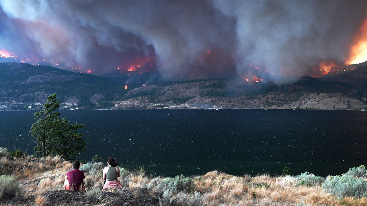
Image credit: Gabor Fricska
The wildfire season across Canada was one for the record books on so many fronts. It began early, ended late, burned faster and was extremely active from British Columbia and the Territories to the Atlantic coast. Fighting wildfires in Canada often occurs on one side of the country at a time; this year massive wildfires were everywhere at once and lasted many months. On June 6, there were out-of-control fires burning in every single province and territory except in Prince Edward Island and Nunavut. The Canadian Interagency Forest Fire Centre in Winnipeg reported that the number of wildfires was above average, but there was an unbelievable record high total of woodland consumed - seven times the 10-year average. As cloud-to-ground lightning activity was recorded at the third lowest level in 22 years between January and September inclusive, lightning was clearly not the only cause of the wildland fires.
Among the wildfire records shattered and statistics of 2023 were:
- 184,493 square kilometres of woodland up in smoke across Canada - the equivalent of nearly 1.5 times the size of the Maritime Provinces. By June 27, Canada had already surpassed its historic record for total area burned but the country continued to burn.
- The amount burned was more than double the previous high of 70,000 square km consumed in 1995 and dwarfed the 10-year average of 27,538 square km.
- According to provincial/territorial forestry officials in British Columbia, Alberta, Québec, Nova Scotia and the Northwest Territories, their jurisdictions burned a record total area, dating back to 1980.
- The area burned in Canada was more than the total area burned in the United States in the last five years --- that is 150,000 square km.
- Two fires exceeded one million hectares in Québec and British Columbia. In 2023 the average size of forest fires was 2,693 ha, compared to the historic average of 350 to 500 ha.
- Fortunately, no civilians died from wildfires, but tragically, at least four firefighters died while on duty in Canada.
- According to the Canadian Wildfire Evacuation Database, by the middle of September, 297 evacuation orders had been issued nationally. Evacuations numbered 235,458 people or as large as the population of Saskatoon, Burnaby or Vaughan. It included 20,000 residents from Yellowknife, Northwest Territories’ capital city and several other communities in southern areas of the territory. Citizens in West Kelowna, British Columbia and Sept Iles, Québec also left home including countless First Nations communities across the country. Even residents in Bathurst Inlet in Nunavut were forced to evacuate on August 11 – the first time a Nunavut community was evacuated for a wildfire. Some residents had to flee two or three times and travel 2,700 km away from home.
- Over 10,800 forest firefighters, nearly half of those from international crews, started fighting fires in May and were still there five months later.
- Property losses from six large fires numbered 17,000 claims for a total of over $1.1 billion not counting wildfires in Québec.
Alberta
This year’s fire season was unprecedented being both exceptionally early and widespread. In early May, a strong high-pressure ridge, said to be the strongest ever seen in four decades, created an early heat wave across the West. In Alberta, May temperatures averaged about 5 degrees warmer than normal – the warmest in 76 years of records. Spring in Alberta was also drier than in recent years and humidity was very low, pushing the start of the fire season much earlier than usual. Among the hot spots, Edmonton broke records for May close to 6 degrees above normal. Calgary had their second hottest May on record, some 4.5 degrees above normal. Once ignited, strong winds fanned dozens of fires in central and northern Alberta forcing 38,000 Albertans to evacuate by May 8. By May 12, nearly the entire province was under a fire ban and 19 local states of emergencies were in effect. In Edson, Alberta residents were evacuated on June 9 for the second time this spring. Flames closed several transportation routes shutting down access to dozens of parks and recreational areas. Fires also halted oil and gas activity representing nearly 5% of the nation’s petroleum production. By the end of May, wildfires had charred nearly 1.2 million ha, almost 100 times more than last year at that time. Around late May and June with rain falling, forest-fire crews began moving East to combat huge fires across the Maritimes and Québec.
Nova Scotia
The Maritimes went through one of their driest springs in several years. At the same time, meagre winter snow cover disappeared quickly leaving the moisture deficit on forest floors scanty and more typical of July than May. From February to May inclusive, total precipitation in Halifax was less than half of normal. Conditions were especially dry in April when several stations in Nova Scotia experienced their driest month on record. In May and early June, temperatures soared to 33°C and, as it turned out were the warmest few days of the entire summer, some 12 degrees above normal. As a consequence, when wildfires started up in May they were intense and fast-moving across Nova Scotia and New Brunswick. Further, significant amounts of fuel were left drying out after Hurricane Fiona raked the region eight months earlier.
Out-of-control fires in late May forced 18,000 people from their homes in Halifax where the Tantallon fire was raging, and in a largely forested area of Shelburne County southeast of Yarmouth - the largest wildfires ever in Nova Scotia. Fires spread rapidly driven by hot, steady, gusty winds. Out-of-control fires prompted officials to impose widespread bans for hiking, camping, fishing and for forestry and mining operations. In total, more than 200 homes and other structures were fire-damaged or destroyed, mostly in northwest Halifax. Property insurance costs were estimated at $250 million. In early June, multi-day rainfalls between 100 and 175 mm helped to extinguish the flames.
Québec
Record-breaking heat around June 1 across western Québec, added to record dry weather through much of winter and spring, created tinder dry conditions across the province. Too many fires ignited at once and spread quickly. June wildfires in Québec burned nine times as much land as in any previous decade combined. Major hot spots occurred in the Abitibi-Temiscamingue region and along the North Shore region of eastern Québec. A state of emergency was declared in Sept-Iles on June 2 forcing 5,000 people out of their homes. Some residents in Lebel-sur-Quévillon had to flee their properties on two occasions. Several mines in the province suspended operations because of the fire risk. Hydro-Québec airlifted close to 200 workers from hydro stations in northern Québec. Foreign fire fighters joined provincial-manned crews to extinguish flames. Hundreds of Canadian Forces personnel assisted with evacuations and firefighting. Northerly winds pushed smoke from Québec and northeastern Ontario fires into Montréal, Ottawa, Toronto and major cities in the eastern United States. Rains at the beginning of July helped extinguish some fires, although large blazes still burned out-of-control near James Bay.
British Columbia
Three years of unusually warm temperatures and scanty precipitation left conditions in much of British Columbia tinder dry at the end of April 2023. May ranked the warmest in 76 years, more than half a degree warmer than the second warmest May in 1998 (also a frightfully bad forest fire year). Much of the winter’s snowpack disappeared quickly denying rivers a steady flow through spring and early summer. By mid-May, special air quality statements and smoky sky bulletins had already been issued for several communities in Northeastern British Columbia. With hot flames and suffocating smoke threatening the region, 40,000 people were under an evacuation order or alert before the long weekend in May. The Donnie Creek fire between Fort St. John and Fort Nelson was well underway. This lightning-ignited fire began on May 12th and was still burning strongly and out-of-control at the end of September to become the longest burning wildfire in the province’s history, and the largest (5,800 square km). Dryness grew worse in summer and consequently fires grew aggressively across the entire province. Often 350 to 400 fires were burning at once with two thirds of them designated as out-of-control. There was rarely a respite for thousands of firefighters or the military. Evacuations from towns, rural areas, resorts, and vacation spots and First Nations communities continued all summer.
In central British Columbia, following months of persistent dryness there was a meagre rainfall of 3.8 mm from July 13 and August 21. The erratic gusty winds, heat-dome temperatures, and thousands of lightning strikes in July ignited hundreds of wildfires in and around the Okanagan. In July, almost 170,000 lightning strikes hit the ground, or 55% more than normal, for the third most active July in 22 years of records. From the Okanagan Valley to the Fraser Canyon and east of Kamloops in the Shuswap-Adams Lake region, fires ignited in July but took off in mid-August forcing thousands of residents to stand on evacuation alert. Temperatures soared between 37°C and 42°C in parts of the Okanagan. The McDougall fire just 10 km from West Kelowna exploded 100 times its original size in less than one week and stayed ablaze for more than a month. Nearly 200 structures in parts of beleaguered West Kelowna, Westbank First Nations and in Kelowna were partially or entirely destroyed including the Lake Okanagan Resort. On August 5, northeast of Kamloops the Bush Creek-Adams Lakes fire doubled in size in two days scorching properties in Shuswap and on both sides of Adams Lake. On August 20, there was hope when Tropical Storm Hilary spun up from Mexico and started wetting eastern British Columbia but not further west where the rain was mostly needed. The airspace above Kelowna Airport closed to support aerial firefighters. In the Shuswap region, 170 homes and businesses were destroyed or damaged by fires. Across the West Kelowna and Bush Creek fires more than 22,000 residents were on evacuation orders or alerts. Even in Osoyoos, wildfires burned properties and forced evacuations but, in this case, it was fires from Washington State that came northward. Fire behaviour in British Columbia received a late-summer boost from higher-than-normal temperatures and lower than normal rainfall, especially in the north. The wildfire season remained in full swing for months. In the first week of October, 317 active fires were still burning across the province.
Northwest Territories
All spring and summer, the Northwest Territories experienced record high temperatures and negligible rainfall accelerating the wildfire threat. But the seeds of the unprecedented fire season were sown at least four years ago. In Yellowknife, almost every month since the end of 2020 was drier than normal for a combined moisture deficit of 340 mm in 36 months. Further evidence of the drought, historic low water levels along the Mackenzie River forced lengthy detours for goods in transit. Around mid-August, a ridge of high pressure settled over the territory sending temperatures soaring further, desiccating forests even more, and worsening conditions because of strong winds and frequent strikes from dry lightning. Forests had enough heat and dry stress and over 200 wild and unpredictable fires ignited with the majority out of control.
The fire front was 60 km away from Hay River, Northwest Territories on August 13 pushed by strong wind gusts up to 70 km/h. The hamlet of nearby Enterprise was engulfed by the blaze and 80% of the town was burned down. By mid-August, fires grew dangerously close to several communities: 2 km from Hay River and 1 km from the airport; 4 km away from Fort Smith; 7 km from K’atl’odeeche First Nation and 15 km from the capital of Yellowknife. On August 18, out of control wildfires around Great Slave Lake forced officials to invoke mass evacuations involving thousands of people (nearly two thirds of the Northwest Territories’ residents), and also forced postponement of territorial elections until November 14. With fires so close and heavy smoke and falling ash choking the city of Yellowknife, an historic evacuation order was issued at 12 pm on August 18 and incredibly, 95% of the city heeded the order and stayed away for almost three weeks. Some travelled as far away as 3,000 km away, returning home after the second week of September. At the end, not all fires were extinguished. On October 16, 303 fires had consumed 4.2 million ha – ten times the 25-year average and with 91 fires still active as of November 21.
2. Canada cloaked in smoke
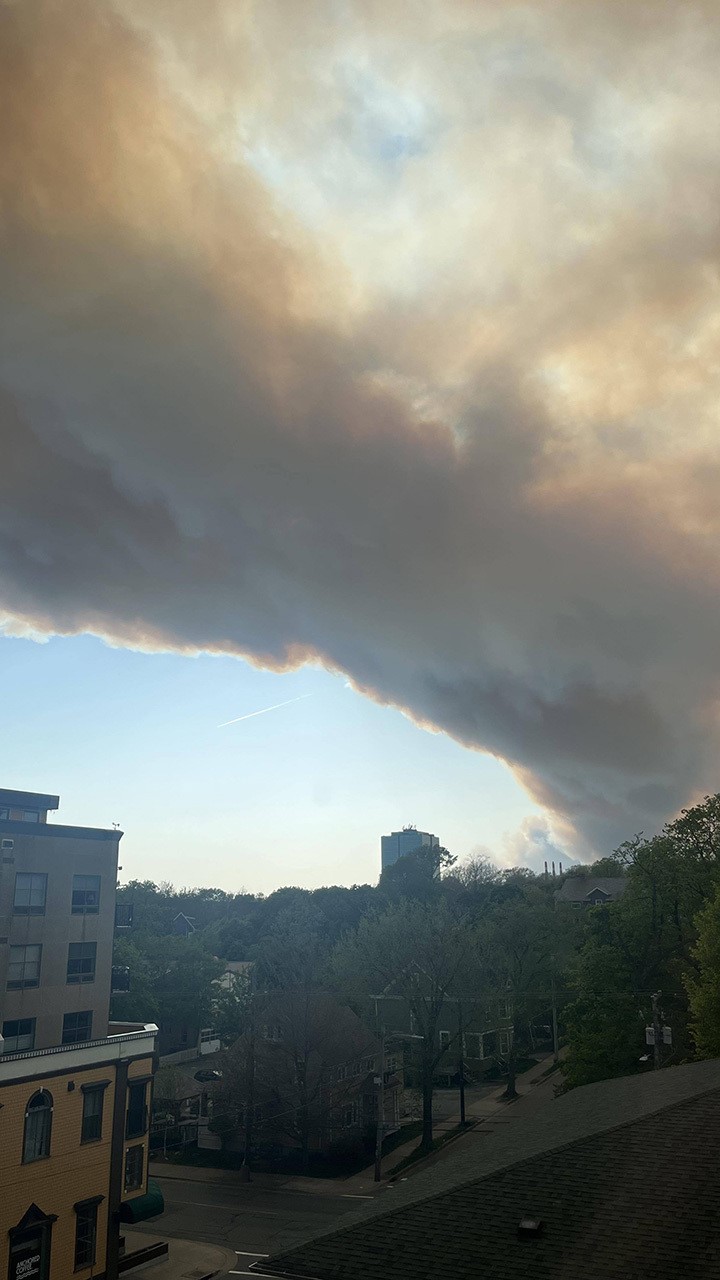
Image credit: Sansom Marchand
With choking smoke filling the air across Canada, nobody was untouched by the devastating wildfires in 2023, and it was not just in Canada. Although Canada usually gets a bad reputation south of border for sending cold air, during the summer of 2023 plumes of acrid smoke travelled to the United States from Canada, making headlines in New York City and in many other parts of the country. More than 100 million Americans faced restricted breathing under poor air quality owing to smoke from Eastern Canada in June and May and later in the summer and fall from western and territorial wildfires. Further, smoke from Canadian wildfires drifted thousands of kilometres across the Atlantic Ocean and fouled the air over Greenland, Iceland and other parts of Europe.
Smoke brought hazy skies beginning in April to northeastern British Columbia when lightning ignited the Donnie Creek fire. Skies were still foul in October with over 753 fires still burning across Canada, nearly half described as “out of control”. In hot fire zones across Canada, poor visibility from smoke was a daily occurrence and so awful that at times fire crews could not even see what they were battling. Before the long weekend in May, wildfires in Alberta had already burned three times the annual burn in an average year. May wildfires in the west had cloaked most of Alberta and Saskatchewan and much of British Columbia with smoke such that air quality health indices were 10+ or very high risk. The risk was so high in Edmonton that the city launched its first extreme weather response to poor air quality: schools began holding recess indoors and cancelling outdoor excursions. Canadians in cities suffered with some of the worst air quality on Earth. At times, smoke shielded fires from the sun keeping temperatures below forecasted highs. Smoke was bad for crops too, hiding the sun and slowing plant growth.
Late summer-early fall fires in the Northwest Territories, British Columbia and Alberta tainted the skies from western North America to the Great Lakes. In September, Yellowknife again found itself menaced by nearby fires, this time by thick smoke that turned skies an apocalyptic dark orange. On September 23, the city-hosted celebrations for returning home from three weeks of wildfire-forced evacuations had to be cancelled due to poor air quality.
In Eastern North America, special air quality statements are not frequently issued due to smoke from Canadian wildfires, especially fires in eastern Canada. Smoky skies this June came largely from fires raging across Nova Scotia, northern and central Québec and northeastern Ontario. A low-pressure system over Maine and off Nova Scotia provided a counter-clockwise flow to funnel Canadian smoke southward.
Occasional rainfall was not enough to extinguish wildfires until winds also had shifted. For much of June, thick smoke covered southern Ontario and Québec in concentrations well past the unhealthy threshold. The smell of smoke was inescapable as yellowish smog blurred city skylines. Montréal had the worst air quality in the world on the morning of June 25. Its fine particulate matter (PM2.5) concentration was 243, reaching 38 times the World Health Organization's air quality guideline. On June 7, air quality in Ottawa was rated high risk at 10+. The amount of fine particulate matter in Ottawa's air hit 511 when PM2.5 normally ranges from 4 to 11. Another blast of smoke at 243 on June 25 forced Dragon Boat Festival and the Summer Solstice Indigenous Festival to be cancelled. The City also cancelled all outdoor recreational programs, closed outdoor pools, and issued no-swim advisories at city beaches. Yellow-tinted smoke settled over Toronto on several days in June. Under smoky haze, the smoke plume was so dense that airports had to pause or slow air traffic operations due to poor visibility. City hospitals saw a surge in the number of people visiting emergency departments with respiratory issues. At times winds would dissipate the smoke and rain scrub the air only for foul air to return within a day or two, often going from bad to worse.
The number of smoke hours from May to early September, as defined when visibility is less than 9.7 km, revealed record-breaking smoke conditions across much of western, central and northern Canada. The city with the highest number of smoke hours was Fort Nelson with 1054 hours, followed by Fort St. John (867), La Ronge (802) and Peace River/Grand Prairie (625-644). Several major cities, including Kamloops, Calgary, Edmonton, Regina, Saskatoon and Yellowknife, experience more than 200 hours of smoke.
3. Hottest Summer – on Earth and in Canada
On Earth
Blistering, baking, broiling, and “hell on Earth” were just some of the descriptors used to describe the record hot summer across the Northern Hemisphere in 2023. There is no question it was the warmest summer since 1940, and likely back to 1850 (the start of the pre-industrial averaging period) and, if reconstructing past climates using geological and biological evidence, likely the warmest in history dating back to when human beings began appearing 120,000 years ago.
June 2023 was the hottest June ever, some 1.5°C above the 20th century average. July 2023 was the warmest month ever recorded globally, beating the previous warmest July in 2019 and some 1.5°C above the 1850 to 1900 average. The United States’ National Oceanic Atmospheric Association declared July 7, 2023 the hottest day on Earth at 17.42°C, beating the previous warmest just days earlier. August 2023 was the hottest August on record. For the three summer months, the Northern Hemisphere averaged 16.77°C - that is 0.66°C warmer than the current 1991-2020 average. September kept the record warmth going when the World Meteorological Organization announced it to be the warmest September on record. In the Southern Hemisphere, well-above average temperatures especially in August also occurred across Australia and New Zealand, several South American countries and around much of Antarctica where sea ice was at its lowest extent since satellite records began in 1979. Thus, with both hemispheres abnormally warm, Earth easily had its warmest June-to-August on record.
Coming out of the warmest summer and September on record, 2023 featured the Earth’s warmest first nine months on record. Several factors contributed to the unprecedented heat. Record marine heat waves across several ocean basins stoked the heat throughout the summer and compounded the effects of ongoing anthropogenic climate change. With super-heated El Nino waters only expanding and strengthening in the tropical eastern Pacific, 2023 is very likely to be the warmest year on record in more than 150 years.
In Canada
Canada contributed more than its share to the Earth’s record hot summer. It was the warmest summer in 76 years, dating back to the start of national record-keeping in 1948. The average temperature anomaly was +2.0°C, beating the previous warmest in 2012. The warmest summers on record (with positive anomalies) also occurred in British Columbia (2.1°C), Yukon Territory (2.9°C) and Northwest Territories (3.1°C). Even more noteworthy, if we add May and September to the traditional three summer months, each province and territory, with the exception of Atlantic Canada, recorded their warmest five months on record. Atlantic Canada was left out of the top because it was too busy being too wet. Ocean temperatures bathing Canadian coastal waters were shockingly hot and with peaks occurring much earlier than ever before. At summer’s peak (July 17 to August 7), the Canadian Atlantic surface waters were 3 to 5 degrees above normal and as hot as it ever has been in the North Atlantic.
Unofficially, a hot day in Canada is defined when the day’s maximum temperature exceeds 30°C. In the British Columbia Interior hot days were far above historic averages. Kamloops recorded 62 hot days in 2023, compared to a historic average of 33. And Lytton, which in 2021 set a new record for the hottest day ever in Canada, topped 30°C for 71 days - 38 days above the average. Canada’s hottest temperatures in 2023 occurred during a sweltering and protracted heat wave in mid-August when the day’s maximum exceeded 40°C in five locations. Lytton was Canada’s hot spot in 2023 at 42.2°C on August 15.
Temperature soared above 37°C in the Northwest Territories in early July. Fort Good Hope, Nunavut reached a record high of 37.4°C on July 8, more than two degrees above the previous record. Within sight of the Arctic Circle, the small town of Norman Wells hit 37.9°C also on July 8. It was easily the farthest north in Canada with a reading of 37°C or higher in the Canadian climate record, and just 0.1°C shy of the hottest temperature ever observed that far north in the world. In Yukon, Carmacks set an all-time daily maximum temperature record on July 7 at 35.5°C the third-hottest daytime temperature ever recorded in Yukon. In Winnipeg, winter ended and summer began on May 1 when the coldest March and April ended and the warmest May and June ever on record began. Both July and August were cooler than normal followed by a very warm September making for a relatively long summer and one of the longest growing seasons on record.
Across the Great Lakes and Atlantic Canada summer temperatures were hardly hot. Some of Canada’s largest cities in the East did not experience a hot day from the second week of July to the first week of September. All that Toronto could muster this summer was 33°C. By mid-summer, Easterners had written summer off. But summer came back when Ottawa registered four days above 30°C in September and two in October. Never before in 141 years of weather records has Ottawa ever seen a temperature above 30°C after September 22. Montréal went 58 days in mid to late summer without registering a 30°C day. Neither Montréal nor Toronto had a 30°C temperature in September in the previous four years. This year’s September sizzle made up for that when consecutive hot days numbered four or five around Labour Day. Even more spectacular, the dog days of summer showed up in early October with at least two days above 30°C. Even after snow and cold arrived in the West at the end of October, parts of the East were still breaking warm temperature records.
4. Deadly deluge in Nova Scotia
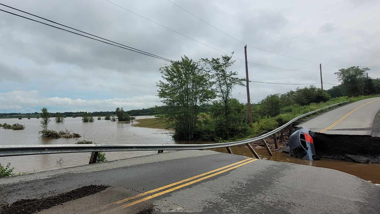
Image credit: Lexie Barkhouse
Following a record dry spring and several 30+°C days at the end of May, fast-moving and devastating wildfires burned through parts of western Nova Scotia and suburban Halifax. While fires burned in early June, incessant rains started squelching flames and lessening the threat of wildfires as the month progressed. By the end of June, 214 mm of rain had fallen in Halifax, nearly 2 ¼ times the average monthly total. July was also wet with 187 mm - nearly double the normal. But in July almost all the rain fell in less than two days on July 21-22 when a slow-moving trough of low pressure moved into the Maritimes. A sizable plume of tropical moisture also streamed into the region from the south and positioned over some of the warmest ocean waters ever seen in the North Atlantic, surface waters two or four degrees warmer than usual. A high-pressure system to the east enabled embedded thunderstorms to tap into the tropical air, efficiently wringing out copious amounts of water. Torrential downpours started in the afternoon of July 21 and by the end of the next day between 200 and 250 mm of rain fell across the province's southwestern shore, in parts of Halifax and in the central and western parts of the province. It was a summer’s total in one day - the most significant rainfall event in the Halifax area since Hurricane Beth on August 16, 1971. Because rains had been falling for most of the previous six weeks, the ground was already saturated with little ability to absorb further rainwater. The consistent nature of the thunderstorms was frightening. At Halifax International Airport, the heavy downpours started just before 4 pm on July 21 following several hours of fog. Over the next 28 hours, rain fell continuously during 10 thunderstorm hours in a process known as “training”. Like freight cars on a railroad spur, new thunderstorms developed as old ones dissipated. It finally stopped raining at 4 pm on July 22. Rainfall intensities were torrential – 100 mm in one hour and 173 mm in six hours in Bedford – a new national record and shattering the once in 100-year rainfall return period.
The Bedford-Sackville area, Hammonds Plains, and the Annapolis Valley experienced some of the heaviest rains in more than half a century. Tragedy unfolded as families fled their homes; four lives were lost, including two young children. The damage and heartache that followed was unimaginable. Rivers formed where there had been roads, with as many as 50 roads remained impassable and 50 more washed out. At least seven bridges had to be replaced or rebuilt and 19 others repaired. About 1000 people were forced to flee their homes overnight. Nova Scotia Power had to deal with outages in the Halifax and Liverpool areas caused by non-stop lightning leaving 80,000 homes and businesses across the province without power.
Nova Scotia saw the most July lightning ever recorded in the province in over 22 years, and almost all of it came from the single storm on July 21: 26,194 lightning strikes in July of which 23,008 struck on July 21 and 22. There was a province-wide state of emergency declared on July 21 for 2 ½ weeks. This is the same area where wildfires destroyed 150 homes two months earlier. Agriculture losses were also extensive owing to flooded fields, road washouts and crops of hay, soybeans and vegetables left submerged for several days.
Following momentous rains on July 21-22, other big storms occurred in July and August leading to more flash flooding and water pooling. Halifax summer rains amounted to twice the normal at 619 mm. Elsewhere in the province at some private weather stations between 700 and 900 mm of rain fell including a whopping 981 mm at Mahone Bay. Total summer rainfall in New Brunswick ranged between 500 and 600+ mm or about 60 to 80% above normal. Rains from Hurricane Lee in September and Tropical Storm Philippe in October only added to the wettest five months in Maritime history.
5. Canada dry in the West and wet in the East
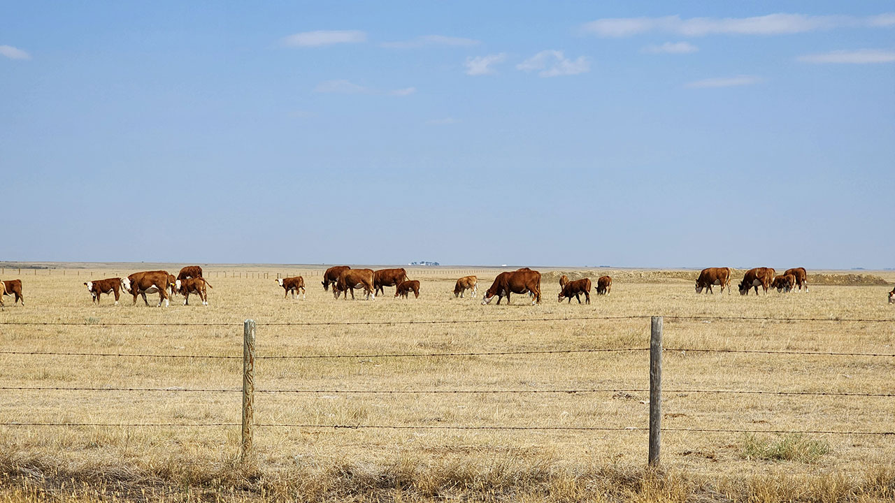
Image credit: Kyle Brittain
At the beginning of June, most of Canada was abnormally dry with large areas in the West in a state of moderate to extreme drought, because the first five months of 2023 lacked precipitation in the region. Drought stretched from coast to coast, in every province or territory. Even farmers in Eastern Canada were concerned about an alarmingly dry spring and maximum temperatures that soared above 30°C in mid-April - never had it been so warm so early in the year. Potato growers in Prince Edward Island were applying more irrigation water in May than in an average July. In Lethbridge, Alberta and Winnipeg, Manitoba, the amount of precipitation from February through May was among the lowest on record in over 100 years, while in Québec’s Cote-Nord region, the moisture shortfall of 150 to 200 mm was the lowest in more than 100 years.
Dry in the West
Across Western and Northwest Canada, a persistent large high-pressure area stationed over British Columbia and Alberta kept rains away and temperatures elevated by as much as 10 degrees above normal for much of the year. The massive blockage prevented an influx of cooler northern air or any moist Pacific air. Also adding to the dryness was the dearth of a winter snowpack at higher altitudes. In some river basins, glacier-fed waters were the lowest in a century. Further, the snow had melted about six weeks earlier than usual. This meant waterways through parts of the Prairies peaked earlier, denying water for irrigation, fighting wildfires, domestic water supplies, and power generation. In Alberta, the flow of the Bow River was the lowest since 1911. More dry and hot weather in the summer further depleted groundwater, leading to river flows in July looking more like those in September or October.
Across British Columbia, 10 months of winter, spring and summer precipitation totals were consistently less than half of normal. Penticton and Vernon experienced their driest summer since records have been kept. Penticton received just 8 mm of rain compared with the normal 105 mm, and Vernon 22 mm instead of its normal 122 mm. And in Kelowna, it was the second-driest summer on record with just 20 mm of rain coming down when 110 mm is the norm. Record drought across the province was a major reason for British Columbia's worst wildfire season ever. By mid-August, more than 80 per cent of the province had reached high to extreme levels of drought - the two highest and worst, possible drought rankings. It was also dry across the southern Prairies and in the Peace River/Grand Prairie region of Alberta. The Northwest Territories was also exceptionally dry extending across Western Nunavut.
Across the West, the enduring drought prompted several communities to declare states of local emergency and impose strict water restrictions. Millions of residents and commercial customers were asked to conserve precious drinking water, even cautioning farmers to be frugal with their water usage, as some water reservoirs were nearing empty. It left some ranchers with no choice but to sell their cattle prematurely. Some locations such as McBride, British Columbia had to endure six or more months of water restrictions. The weather was a challenge to the province’s power-generating sector with production the lowest in 15 years. With low water levels, it became too hot for fish to survive and oxygen was depleted, leading to a massive die-off of steelhead trout and salmon. In Alberta, authorities with the St. Mary’s River Irrigation District declared it one of the six driest in the past 99 years. Along the Mackenzie River in the Northwest Territories, transport companies had to truck - rather than float on barges - goods and commodities at much higher costs.
On June 1, two separate thunderstorms featuring intense rain dumped more than 40 mm of rain in Regina. The flash flooding led to basements filling and cars floating. Underpasses filled and cars ploughed through flooded streets creating a wake from rising waters. With all the talk of drought and wildfires in the West, an exception was an area between Red Deer and Edmonton, which was hammered by several days of heavy rains on June 17-20. Rains between 70 and 140 mm fell and in mountainous areas such as Jasper, 20 to 30 cm of snow fell. Edmonton was a real anomaly this summer recording almost 60% more rain than normal. Some residents of the town of Edson, twice forced from their homes by earlier forest fires, were now leaving home due to flooding. On August 24, strong super-cell thunderstorms brought large hail and torrential rainfall to several communities from Manitoba’s Interlake Region through the northern parts of Winnipeg. Selkirk got 110 mm in 30 minutes and Winnipeg got between 20 mm and 30 mm. It stayed dry in British Columbia right up to October 17-19 when an atmospheric river dumped 100 to 200 mm across coastal and central parts of the province.
Wet in the East
Summer in Southeastern Canada was as moisture-laden as the West and Northwest were dry. Stagnant low-pressure systems were repeatedly positioned between James Bay through the Great Lakes to the Maritimes favouring lengthy bouts of rain, overcast and coolness. Frequent weather systems brought in loads of moisture from tropical sources keeping surfaces wet from days of heavy rain or continuous drizzle. Lows moved in slowly, stalled or retrograded for weeks at a time. Further, there was an absence of the customary Bermuda High and its sunny and dry weather. The Maritimes experienced its wettest summer in history, more than double the normal amount of rainfall. Among the many stations in the Maritimes breaking summer rainfall records were Yarmouth, Greenwood, Kentville, Sydney, Saint John, Fredericton, and Charlottetown. Private weather stations along Nova Scotia’s south shore recorded 843 mm in Liverpool; 981 at Mahone Bay; and 500 to 600+ mm in southern New Brunswick. Saint John received a total of 763 mm of rain in June, July and August, which is almost three times the normal of 271 mm. It rained hard and often. There were 52 days in the summer with some rain when normally there would be 35. There were 24 days with rainfall amounts of 10 mm or more, when normally you would see 11 through summer. Normally, there would be three heavy rainfall events with more than 25 mm of rain, but Saint John had 11 events.
Around July 10 to 12, record rains led to dramatic rises in Québec waterways leading to flooding and evacuations from Saguenay to Sherbrooke. More than 135 mm in less than 48 hours sent rivers surging, including the St-Francois River which rose from 2 to 6 m in less than four hours. By the end of July, Sherbrooke recorded three times its normal monthly total. Early on July 12 and into the next day, severe thunderstorms moved through southern Ontario and Québec causing flash flooding and wind damages from tornadoes. Rainfall totals ranged from 50 to 80 mm from Sarnia to Orillia and 50 to 90 mm of rain through the St. Lawrence Valley in Québec, including another 90 mm dump in Montréal.
On July 20-21, another classic undercutting cold front of warm humid air triggered a series of supercell thunderstorms travelling from near Windsor to southern Québec. The weather featured microbursts, tornadoes, hailers with baseball-size hail and torrential flash floods. Joliette, Québec received the most rainfall, between 100 to 120 mm, with most of it within two hours. Barely a week later, a series of severe thunderstorms dropped more heavy rains resulting in flash flooding from Southwestern Ontario to Québec City. Storms led to widespread street flooding and left 55,000 without power. On August 3, more storms moved through southern Ontario and Québec, packing billiard ball-size hailstones, violent wind gusts in excess of 110 km/h and torrential downpours. On August 10, between 80 to 120 mm of rain in about an hour and a half fell across Montréal. Roads and underpasses were submerged along with warehouses, schools and lower levels of shopping malls. In Ottawa, with 100 mm of rain in six hours, roads became canals. To avoid flooding, motorists drove on sidewalks or abandoned their cars. Two weeks later a steady stream of showers and thunderstorms pushed through southwestern Ontario on August 23 and 24 bringing storm rainfalls as much as 185 mm to several locations. Flooding led to road washouts and the tragic death of a trucker who perished in a 3-m deep sinkhole. Greatest rainfall totals exceeded 200 mm in Pelee Island and Harrow, Ontario. Some of the moisture came from the remnants of Tropical Storm Hilary from Mexico via British Columbia and the prairies. Insurance costs to property losses from some of the more impactful storms this summer in Ontario and Québec totalled more than three quarters of a billion dollars.
6. Hurricane Lee… no Fiona but more than a windy day
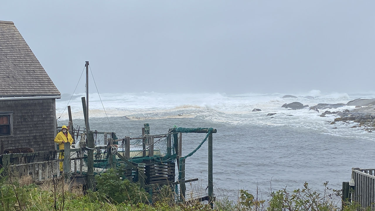
Image credit: Doug Mercer
In early spring, forecasters predicted a below normal to average number of tropical storms for the Atlantic Ocean basin in 2023. That would be a change from six years of active storm seasons. An El Nino established and strengthened in the tropical Pacific Ocean, stronger atmospheric wind shear would most likely suppress the development and growth of Atlantic tropical storms by blowing the storms apart. However, by early August, forecasters revised their numbers upward calling for up to 21 named storms. El Nino was still present, if not stronger. However, record hot tropical seawaters would potentially counterbalance the shearing effects of El Nino.
Around mid-August, the Atlantic hurricane season came alive after several weeks of little to no tropical activity. Tropical Storm Franklin, the season’s first major storm, remained offshore as it passed south of Atlantic Canada at the end of August. St. John’s, Newfoundland and Labrador received about 36 mm of rain over 19 hours on August 30 and 31, with wind gusts peaking at 76 km/h. On September 23, Ophelia was the 15th storm of the season. Only six storms were hurricane strength, of which three were major (Franklin, Idalia and Lee).
In the Pacific, Tropical Storm Hilary was an odd storm of sorts. She formed over the Mexican State of Baja dropping a record 330 mm of rain in 24 hours on the Baja state before barreling up the hot Gulf of California and bringing record rains to Southern California, Arizona and Nevada. After soaking the desert southwest, she headed northward bringing badly needed rains to the eastern parts of British Columbia in the Kootenays and the Columbia Valley on August 20, but not to the rain-starved and fire-swept Okanagan Valley. The remains of Hilary moved across Saskatchewan and Manitoba on August 22. Two days later Hilary’s leftovers merged with another storm over southern Ontario. Several rounds of rain brought two months of rain in two days - above 200 mm - to communities there, causing extensive road flooding, filled basements and garages, and backed-up sewers. Major highways were closed for up to 12 hours due to flowing water. Near Glencoe, a life was lost after a transport truck fell through a sinkhole on a district road.
In early September, another weather disturbance emerged from the west coast of Africa. In the next days, a tropical cyclone formed and quickly intensified into a powerful hurricane over the central tropical Atlantic. Storm Lee grew from a Category 1 to 5 hurricane in less than 24 hours with winds at 269 km/h - the third most rapidly intensifying storm in history and one of the 40 most powerful storms ever recorded in the Atlantic basin. As quickly as Lee grew, it weakened to a Category 3, but still a major hurricane. Hurricane Lee passed north of the Caribbean Sea on the 11th and started traveling toward the Gulf Stream. It stayed out over the ocean, and on the 14th, headed straight north for New England and the Canadian Maritimes. As Lee began to lose its strength, across the cooler Northern waters, some churned up by the blustery motion of storms Franklin and Idalia, it also widened its wind field as it transitioned to a Post-Tropical Cyclone. At one time, Lee’s size extended out to 145 km with hurricane-force winds and 500 km with tropical storm winds. Few Maritimers would not feel the effects of Lee’s wrath no matter where it made landfall during the weekend. Even while diminishing, Lee packed tree-felling wind speeds, flooding rains, and high surf to parts of coastal New England and into southwest Nova Scotia and the Bay of Fundy on the weekend of September 15 to 17, almost a year after Hurricane Fiona hammered the Maritimes, Québec and Newfoundland. Lee was compared to Fiona but, as it turned out, it was not the same intensity and magnitude storm.
Lee became a post-tropical storm around 6 am Saturday, September 16 but retained its Category-1 force winds. Lee first made landfall on Long Island, Nova Scotia in the Digby Neck late afternoon and in a second landfall in New Brunswick and Prince Edward Island after crossing the Bay of Fundy. Winds blew over 100 km/h at landfall in the west and northeastern area of Nova Scotia but peak winds were clocked at 117 km/h at Halifax International Airport. Large waves topped 5 to 7 metres with a peak wave at the Halifax harbour buoy of 16 metres. Storm rainfalls ranged from 50 to 150 mm. Days before Lee’s arrival as a post-tropical storm, store shelves started emptying from a wary citizenry still remembering the impacts of Hurricane Fiona. Residents stocked up on propane, bottled water, canned goods, batteries and flashlights and “storm chips”. Boaters pulled their vessels from the water and lashed down their gear along the coast. Many flights and ferry crossings were cancelled. At the height of the storm, 350,000 customers were without power and internet connection. Of major concern in the Maritimes was the sodden ground from weeks of heavy rain in a full summer of torrential record rains. Leafed trees made it easier for Lee’s winds to bring down trees and power lines. The storm surge pushed large waves and rocks onto coasts, destroying beaches and parks and washing out trails. Some beaches and parks, like Rissers Beach Provincial Park in Nova Scotia, were completely ruined; coastal roads were made impassable, bridges closed, trees downed, basements flooded, signage was scattered and traffic lights were left dangling.
Three weeks later, the Saturday of Thanksgiving weekend, tropical storm Philippe tracked very close to where Lee had made landfall in the Maritimes. Not as powerful as Lee, Philippe also transitioned into a post-tropical storm after merging with a non-tropical system and brought between 50 and 80 mm of rain and strong winds between 70 and 90 km/h across the Maritimes and parts of eastern Québec but leaving Newfoundland and Labrador alone. Significant wave heights south of Nova Scotia reached above 5 metres but were not a problem in the Bay of Fundy.
7. April glaze storm in Montréal-Ottawa – more beast than beauty

Image credit: Brittaney Pilon
On April 5, 2023 before the Easter weekend, a powerful late-season storm moved into the Great Lakes-St. Lawrence region bringing widespread freezing rain, ice pellets, hail and heavy rains. Ahead of the storm, mild air flooded the region and a cold front undercut the mildness, destabilizing the atmosphere. The unsettled weather prompted tornado watches in southwestern Ontario and heavy rain warnings across the province. Persistent winds through the low-lying valleys of the Ottawa and the St. Lawrence rivers kept surface temperatures hovering just below freezing for most of the day. The bad mix led to several hours of freezing rain and rain with a few early season “thundersnows”. Hearing thunder and the ping of freezing ice balls bouncing off surfaces created a real buzz across eastern Ontario and southern Québec. The ugly weather then featured up to twelve continuous hours of freezing rain in Montréal and nine in Ottawa. Ice accretion amounts totalled 30 to 37 mm in Montréal, 25 to 30 mm in Ottawa-Gatineau, and 15 to 25 mm in central Québec. Accompanying wind gusts of 60 to 70 km/h for two days added enormous stress to ice-encased utility lines and trees.
Where heavy rain fell on still-frozen ground, localized flooding swamped backyards and fields and filled basements. Ice build-up on trees and power lines caused extensive damage, including the loss of 300 trees in Montréal. Power outages topped one million customers in Québec including half a million in Montréal and 200,000 in Ontario. Thousands were still without power two days later. There were numerous vehicle accidents and traffic was slowed or stopped on several routes. Sidewalks were also coated with treacherous ice. Ottawa’s light-rail transit went down leaving dozens of commuters waiting hours to be evacuated. Fallen branches and limbs littered streets and properties, damaging cars and smashing windshields. Sadly this ice storm took two lives in Québec. Rising temperatures the next day created the ominous sight and sound of ice falling from trees, power lines and balconies. Numerous businesses were closed including clinics and schools, although libraries remained opened to assist as electricity recharging stations. Property losses from floods, winds and icing topped $335 million from Sarnia to Saguenay.
8. Cold spells in a warm year
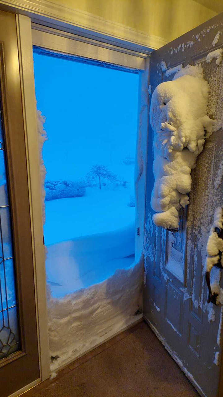
Image credit: Lauren Eldridge
Days before Christmas 2022, and between Christmas and New Year’s Day, Canada was over-run by cold air, dangerous wind chills and all kinds of precipitation from heavy rains, freezing rain and ice pellets to heavy snows in blowing conditions. Travel was treacherous and several flights and trains were cancelled or delayed to the point of ruining holiday plans for thousands of Canadians. In addition, power outages were widespread and lengthy making for uncomfortable and disappointing end-of-the-year celebrations. On December 30th and 31st, the weather changed dramatically with the arrival of mild and dry weather. A new year saw a pronounced January thaw from coast to coast. Monthly January temperatures averaged between three to six degrees above normal from Alberta to Newfoundland-Labrador. In parts of Ontario, January was the fourth warmest month in more than 100 years of record-keeping.
The four-week balmy spell only added to the severity of the cold at the end of January with a swing to numbing cold. Extreme cold warnings were issued for eight provinces and three territories, shattering several temperature records. The cold snap stood out for its severity but not duration – one of the most intense in recent years. Fortunately, the lack of a blocking high over Greenland allowed less cold air to rebound in the second week of February. Before that, the stratospheric polar vortex sat over Nunavut and the northern part of Hudson Bay in mid-January. On January 14, the deep polar low led to a record -62.4°C in Tongulakh, Siberia - the coldest day recorded anywhere in Russia in the past 20 years. A stationary and circular jet stream kept the polar vortex tightly tied up over the North Pole. Two weeks later an amplified jet stream dislodged the frigid air and the cold pool started to wobble. Eventually, a lobe of the polar vortex dipped southward pushing through Western Canada. Across most of British Columbia in January, temperatures averaged 5 to 15 degrees colder than normal. Eventually, the wavering jet stream took the cold across southeastern Canada creating temperatures up to 20 degrees colder than normal. The cold low also came with blustery winds creating biting wind chills as low as -55. South of the border at Mount Washington in New Hampshire the same wind and cold produced a record low wind chill of -77.
For eastern Canada, the first week of February featured the coldest air of the entire winter including punishingly cold wind chills. On February 4, 2023, Fredericton recorded -28.9°C; Saint John dipped to -29°C including a wind chill of -47 – an all-time lowest; Ottawa registered -33.1°C on the morning. The dangerous cold elevated risks of frostbite and hypothermia across the country. Hydro utilities struggled to keep up with power demands leading to record consumption. At the peak of the outages, more than 34,000 Maritimers were without power. Frozen and burst gas and water pipes led to flooding and broken infrastructure inside residences, and commercial and municipal structures. Property insurers across eastern Canada reported losses to the tune of $152 million. Travel was also impacted with flight cancellations and delays in public transit. Road assistance services were backlogged several hours. Thousands crowded into shelters and food banks. Even ski resorts reported lower weekend turnouts and reduced hours of operation because it was just too cold to ski. The cold finally started growing ice on the Rideau Canal in Ottawa but not enough to create safe skating conditions for Winterlude; for the first time its 53-year history, it was impossible to skate on the Canal in 2023.
More cold warnings came into effect during the last week of February, especially in the West. On February 22, extreme cold warnings were issued in Alberta with temperatures feeling like -40 with the wind chill. Adding to the cold were bouts of messy precipitation; 30 cm of snow fell in Calgary, resulting in multiple crashes. In parts of the Prairies, the cold lingered well into March. Winter-weary Winnipeggers broke a record that stood since 1899 with no day in March above 0°C for the first time in 124 years. Farmers and ranchers began struggling financially with having to keep lambs warm and dry and calves and mother cows needing extra shelter and bedding. For some Prairie locations, their coldest moments of the winter occurred in the last 10 days of March. At the end of February, a Pacific frontal system brought around 5 to 15 cm of snow along the Pacific coast. The cold and icy rain and deep snow left a widespread mess to clean up with spun out vehicles, tree-blocked roads and slushy streets and sidewalks. The late-season snowfall caused flight and ferry cancellations, traffic delays and school closures. More snow fell in Vancouver on April 2, which meant that Vancouver got snow six months in a row from November to April, for the first time in 100 years of recorded history.
9. Flooded out: Québec’s Record Wet July

Several major weather systems loaded with tropical-sourced moisture brought frequent, intense and flooding rains to central and southern Québec through July. Slow-moving, soppy storm systems were trapped between areas of strong high pressure over Greenland and Western Canada bringing repeated rounds of rain, many embedded with thunderstorms, across the province leading to one of the wettest months ever. By month’s end, Montréal and Québec exceeded 200 mm of rain, more than double their normal monthly accumulation. Sherbrooke was the rainiest with 311 mm over 21 days, including six days with over 28 mm of rain per day, and a monthly total 2.5 times the normal. Besides summer thunderstorms there were occasional tornadoes and downbursts too.
The first significant soaking occurred on July 1 when severe thunderstorms dumped torrential rains in the Rivière-Éternité area of the Saguenay-Lac-Saint-Jean region. The resulting flash floods caused roads to collapse, killing two people. Most rain and storm damage occurred during the second week of July. On July 10-11, a slow-moving storm moved up from the American Seaboard dumping huge amounts of rain across an area from Montréal-Sherbrooke-Québec City-Saguenay. Hard to imagine any city handling as much rain as these Québec cities when nearly 80 mm fell in two hours on the 10th, made worse by heavy rains of 40 mm or more days before, and an additional 125 mm in days after. Near Québec City, the town of Sainte-Brigitte-de-Laval declared a state of emergency when more than 300 people were forced from their homes. More people were threatened with evacuations when the Saint-François River, which cuts through Sherbrooke, rose six metres in four hours. Sherbrooke had never seen the Saint-Francois River so swollen. Diluvian rains forced the closing of several highways and city streets across the province. In central Montréal, rising waters filled underground parking lots and basements, flushed intersections, swept away culverts, and destroyed key infrastructure.
The intense rains and strong wind gusts up to 111 km/h forced delays in dozens of flights out of Montréal Trudeau International Airport. The summer of widespread power outages continued across the province arising from fires in the north and floods in the south. Hydro-Québec reported 500,000 customers without power at the storm’s peak. Repeated storms just days later added more water to waterlogged soil and swelled rivers and overloaded municipal sewers. Outside cities, heavy soaking rains left farm fields saturated and led to erosion, ground subsidence and minor landslides. The soggy scene was repeated on July 20 to 21 and a week later on the 28th and 29th as storms developed and redeveloped between Montréal and Québec. On July 20-21, street flooding in southern Québec forced numerous road closures between Gatineau and the Eastern Townships. Joliette measured 100 to 120 mm of rain (90 mm in less than two hours).
By the end of the month, many large municipalities in Québec had come through their wettest July on record. For Montréal it was the wettest July measured at the Airport on record since 1941. In Québec City, it was a record in 150 years, and a similar situation in Sherbrooke. Insurance losses to personal and commercial property from five significant July storms totalled $330 million.
10. Canada Day tornado in Alberta
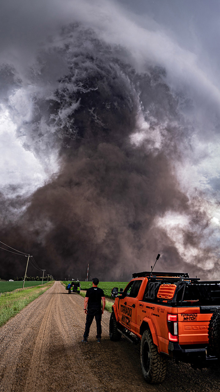
Image credit: Ricky Forbes
On the last days of June and into July, the western Prairies saw days with high temperatures, elevated humidity and unsettled weather. Heat and storm warnings were in effect for much of Alberta. On June 29, Calgary was drenched with heavy rain from a severe thunderstorm causing flash flooding. On July 1, atmospheric conditions really started to boil up along the foothills of the Rockies. Around noon, a severe thunderstorm near Sundrie intensified into a supercell. Shortly before 2 pm, a tornado came twisting out of the supercell on farmland about 70 km north of Calgary. Rain and hailstones the size of golf and tennis balls and strong winds above 100 km/h accompanied the tornado. The twister ripped through 15 to 20 km of rural land about 670 metres at its widest. Estimated wind speeds topped 275 km/h between Didsbury and Carstairs. Based on the damage observed, the tornado received an EF4 rating on the Enhanced Fujita Scale.
The debris field was unbelievable with toppled and debarked trees, downed power lines, and wrecked buildings. Wind tossed and rolled weighty farm equipment - such as a 10,000-kg combine - like toys, and snapped trees like matchsticks. The tornado damaged a dozen homes. No major injuries or fatalities were reported, however, 40 farm animals lost their lives to the storm. As the severe storms moved across Alberta and into Saskatchewan, they continued to take out trees and rows of fences, and sever gas lines. Debris landed on vehicles and campers adding to the cost of the insured property loss which totalled $100 million from 5,000 claims. Among those Saskatchewan communities inflicted with major losses were Nipawin and Hafford, Tisdale, Tobin Lake and Carrot River. There were 20,000 SaskPower customers without power.
It was a busy summer for tornadoes in Ottawa with five tornadoes including an EF1 storm on July 13 that struck Barrhaven, 20 km south of the Ottawa city centre. A research project from Northern Tornado Project out of Western University (NTP) found about 20 tornadoes occurred across the Ottawa Valley over the past six years. It included seven tornadoes on September 21, 2018, one of which was an EF3 in the Dunrobin region with winds up to 265 km/h.
Alberta’s Canada Day tornado was the most highly rated twister nationally in 2023. Moreover, it was one of the strongest top 20 tornadoes in Canada’s history to be classified as violent or catastrophic (EF ratings of 4 or more). It is one of only three F4 tornadoes in Alberta and the strongest since the F4 tornado that struck Edmonton 35 years ago. The country's only documented F5 tornado occurred in Elie, Manitoba in June 2007. About 82 tornadoes occurred in 2023. Ontario led with 39 twisters, while 16 occurred in Alberta. While Saskatchewan has an average of 14 tornadoes per year (with highs of 25 in 2022 and 33 in 2012), only one tornado was reported in the province this year.