Wildlife and habitat monitoring at Turkey Lakes watershed
The Canadian Wildlife Service "Acid Rain" Biomonitoring Program - "Integrated Wildlife, Food Chain and Aquatic Chemistry Monitoring"
Goal:
To verify that acid rain control programs in Canada and the USA are protecting aquatic ecosystems by assessing both the degree of environmental improvement achieved and the adequacy of control programs.
Approach:
Undertake sufficient regional monitoring so that chemical and biological trends may be resolved from normal variation. Collect long-term ecological data to evaluate (at several spatial and temporal scales) the recovery of acid-sensitive lakes and wetlands that are expected to respond to reduced acid deposition
Brief History of the CWS LRTAP Biomonitoring Program
The Canadian Wildlife Service (Ontario Region; CWS-OR) Long Range Transport of Air Pollutants (LRTAP) Program began in 1980, as part of the overall Environment Canada LRTAP Program. The CWS-OR program has focused on the chemical and biological effects of acidic precipitation on small lakes and wetlands across central and northeastern Ontario, primarily in the boreal ecozone. These types of habitats were chosen for three reasons: a) DFO, as well as provincial agency monitoring, tended to cover the larger, cottage-type lakes, and was more concerned with monitoring effects on fish (particularly sportfish), b) small, boreal lake habitats are particularly sensitive to the effects of acidic deposition (both SO4 and NOx), as well as many other environmental stressors (including UV-B, toxics, climate change, etc.), and c) the smaller water bodies are more productive and important for wildlife, especially waterfowl, which together with other wildlife represent an important socio-economic resource threatened by acidifying emissions. From the outset, the program has taken an integrated, whole ecosystem approach, collecting and analysing data on water chemistry, watershed characteristics, and structure and biodiversity of aquatic food chains, with particular attention paid to organisms at the top of these food chains, notably waterfowl and loons. Research through the 1980s led to the development of the CWS-OR LRTAP Biomonitoring Program in 1987, which continues today. Monitoring studies are targeted in three distinct regions of Ontario that differ in historical effects of and anticipated responses to sulphur and nitrogen acidifying emissions: Algoma (n=230 lakes), Muskoka (n=220 lakes) and Sudbury (n=140 lakes). These sites were chosen specifically to overlap other federal (e.g. Turkey Lakes) and provincial (e.g. Plastic Lake, Sudbury area) monitoring sites, for which accurate atmospheric deposition and calibrated watershed data were available for regional evaluation of critical loads.
Components of the CWS LRTAP Biomonitoring Program
The program is made up of four main components: water chemistry monitoring, waterbird monitoring, aquatic food chain monitoring, and predictive modelling. The first three components are directed at establishing whether there are changes occurring in lake chemistries in response to reduced SO4 deposition (i.e. chemical recovery), and if corresponding changes are occurring in aquatic food chains and top predators (i.e. biological recovery). Using these data, biological models have been developed (fourth component) to predict the response of biota to future emission reduction scenarios.
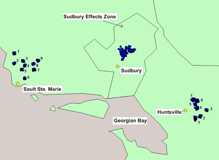
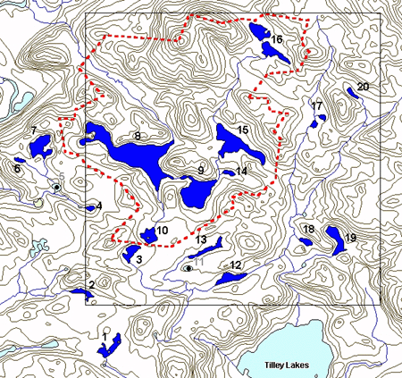
The CWS-OR LRTAP Biomonitoring Program surveys about 230 lakes in the Algoma region (see Figure 1) in a series of 9 plots. Plot 2, containing 20 lakes, is located around the TLW (Figure 2). All lakes and ponds in the TLWare sampled. Chemical and biological sampling was initiated at the TLW in 1988.
Water chemistry monitoring is conducted once annually (first week of October) at the TLW. Mid-lake surface grab samples (for lakes < 3 m deep) or integrated tube samples (for deeper lakes) are collected by helicopter and filtered and analyzed at the Great Lakes Forest Centre.

Figure 1: Long Description
Location of CWS-OR LRTAP Biomonitoring Program study sites in Ontario. The CWS-OR LRTAP Biomonitoring Program surveys about 230 lakes in the Algoma region in a series of 9 plots.

Figure 2: CWS-OR LRTAP Biomonitoring Program Plot 2, with the outline of the Turkey Lakes Watershed in red
Waterbird surveys are conducted by helicopter in May to locate and count indicated breeding pairs of various species, and again in July to locate and count their broods. All lakes that are sampled for water chemistry are also surveyed for waterbirds. The principle waterbird species observed are piscivores: common loon (Gavia immer), common merganser (Mergus merganser); dabbling ducks: mallard (Anas platyrhynchos), American black duck (Anas rubripes), wood duck (Aix sponsa); and diving ducks: hooded merganser (Lophodytes cucullatus), ring-necked duck (Aythya collaris), common goldeneye (Bucephala clangula, the commonest duck observed in the watershed and region - Figure 3).

Figure 3: Long Description
A flock of common goldeneyes (Bucephala clangula). The most common duck in the Algoma region
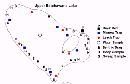
Food chain sampling is conducted as part of the CWS LRTAP Food Chain Monitoring Program. Principal prey items of local waterbirds (aquatic invertebrates, fish and amphibians) are sampled using standardized protocols from the littoral zones of selected lakes. At the TLW, Upper Batchawana Lake (or Batchawana Lake North, see Figure 4) is sampled, as is another lake just outside the TLW (Lake 7 in Figure 2). Sampling methods include sweeps (primarily for nekton), hoops (for trichopterans), benthic drags (odonates, trichopterans, molluscs), funnel traps (for leeches) and minnow traps (for fish and amphibians, as well as large nekton like belostomatids).

Figure 4: Sample sites in Upper Batchawana Lake for the CWS-OR Food Chain Monitoring Program.
Biological modelling takes data accumulated under the various monitoring components and uses this information to develop statistical relationships between physical and chemical characteristics of lakes (notably pH or alkalinity) and the probability of occurrence of various species (e.g. loons) on those lakes, as ameasure of habitat suitability. Once developed, these models are linked to chemical models that predict changes in lake chemistry under emission reduction scenarios, and hence we can predict changes in habitat suitability for various biota as acidifying emissions are reduced.