
Report to Parliament 2015 to 2016: Canada Water Act: chapter 4
2. Canadian Environmental Sustainability Indicators
The Canadian Environmental Sustainability Indicators (CESI) program reports on the status and trends of key environmental issues. Indicators cover air quality, greenhouse gas emissions, water quality and quantity, and protecting nature.
The program’s freshwater quality indicator provides an overall measure of the ability of freshwater bodies to support aquatic life (plants, invertebrates and fish) at selected monitoring sites across Canada. The freshwater quality indicator is calculated using the water quality index, endorsed by the Canadian Council of Ministers of the Environment, to summarize the status of surface freshwater quality in Canada. This indicator reflects the extent to which water quality guidelines for the protection of aquatic life are being met at selected river monitoring sites throughout Canada. When water quality is rated poor, water quality measurements usually exceed the guideline, and the exceedances may be large. Water quality at a monitoring station is considered excellent when ambient water quality does not exceed guidelines at any time for any selected parameter.
Freshwater Quality Categories
Excellent = measurements never or very rarely exceed water quality guidelines.
Good = measurements rarely exceed water quality guideline.
Fair = measurements sometimes exceed water quality guidelines and, possibly, by a wide margin.
Marginal = measurements often exceed water quality guidelines and/or by a considerable margin.
Poor = measurement usually exceed water quality guidelines and/or by a considerable margin.
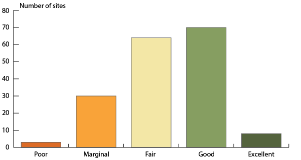
The latest freshwater quality indicator is based on data collected from 2012-2014 at 327 water quality stations across Canada and reflecting the diversity of watersheds in the country. The data were assembled from 23 federal, provincial, territorial and joint water quality monitoring programs. The national water quality indicator was calculated using a core national network of 175 river sites, selected to be representative of surface freshwater quality across Canada and the human pressure exerted on it (Figure 5).
Freshwater quality measured at these 175 river sites across Canada was rated poor at 3 stations, marginal at 30 stations, fair at 64 stations, good at 70 stations, and excellent for the protection of aquatic life at 8 stations. Overall, there has been little change in the national freshwater quality indicator between 2003-2005 and 2012-2014 at the 97 stations for which there are data for that entire period. During this period, no change was detected in the freshwater quality indicator rankings for 81 stations, while the ranking has significantly improved for 10 stations and declined for 6 stations (Figure 6).
Figure 5: National freshwater quality indicator for the 2012-2014 period, Canada
Description of Figure 5
The bar graph presents freshwater quality rating in rivers selected to be representative of the regions of Canada where human activities are most concentrated for the period 2012 to 2014. The bars show the number of sites where freshwater quality was rated excellent (8), good (70), fair (64), marginal (30) and poor (3). Ratings are based on data from 175 monitoring sites.
Note: Freshwater quality was assessed at 175 stations throughout Canada’s 16 drainage regions where human activity is most intensive, using the Canadian Council of Ministers of the Environment’s Water Quality Index.
Source: Data assembled by ECCC from federal, provincial, territorial and joint water quality monitoring programs.
Figure 6: National freshwater quality indicator change from 2003-2005 to 2012-2014, Canada
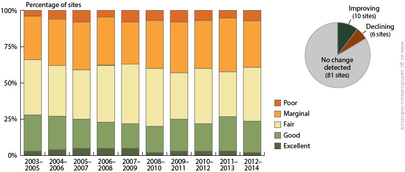
Description of Figure 6
The bar graph shows the percentage of sites where freshwater quality was rated excellent, good, fair, marginal and poor between 2003-2005 and 2012-2014. The inset pie chart shows the number of sites where the freshwater quality indicator has improved, where it has deteriorated, and where no change was detected. Between 2003-2005 and 2012-2014, the freshwater quality indicator rankings have improved at 10 sites and declined at six sites. No change was detected at 81 sites.
Note: Change in the indicator between the 2003-2005 and 2012-2014 periods was assessed at 97 stations in 16 drainage regions across Canada where historical data were available. For each station, change in the indicator was assessed using a consistent set of water quality guidelines and parameters through time.
Source: Data assembled by ECCC from federal, provincial, territorial and joint water quality monitoring programs.
The water quantity in Canadian rivers indicator summarizes annual trends in the hydrometric data at the national scale. Water quantity at a station is judged by comparing daily water flow data to the amount of water observed at water quantity monitoring stations from 1981-2010. Daily data are rolled up to annual patterns for a station, which are summarized nationally.
The latest water quantity in Canadian rivers indicator was released in April 2016 and uses 2013 data for 866 hydrometric stations across Canada rolled up nationally.
In 2013, 27% of 866 water quantity stations were classified as having higher-than-normal quantity, 6% had lower-than-normal quantity and 67% had normal quantity. From 2001 to 2013, Canada's rivers typically had normal water quantity with an increasing tendency for higher-than-normal quantity starting in 2010. The percentage of stations with lower-than-normal quantity has declined since 2001.
Figure 7: Water quantity in Canada’s drainage regions, 2001 to 2013

Description of Figure 7
The proportional column chart shows the percentage of stations with low, normal and high water quantity, on an annual basis, from 2001 to 2013. Over this period, Canada's rivers typically had normal water quantity.
Note: The water quantity classification for a station is based on a comparison of the most frequently observed flow condition in a given year with typical water quantity at that station between 1981 and 2010. The normal period for the Northern Quebec drainage region was 1971-2000, instead of 1981-2010, because of a data gap in the drainage region. The 2013 data has fewer stations contributing to the results because of delays getting data into the HYDAT database. Normal water quantities are specific to each region and do not refer to the same amount of water in each drainage region (e.g., normal water quantity in the Prairies is different from normal water quantity in the Maritimes).
Source: Water Survey of Canada, Environment and Climate Change Canada (2015) HYDAT Database.
Other water indicators can be found online.