
Boundary dispute
Backgrounder
Quotes
“Nunavut is excited to learn about the new changes to our territory’s boundaries and view this agreement as a benefit to Inuit and local communities. Our government is also encouraged to see that the agreement calls for continued access to and freedom of movement on the entirety of Tartupaluk island, including for hunting, fishing and other related cultural, traditional, historic and future activities for the Inuit of Nunavut and Kalaallit Nunaat.”
- P.J. Akeeagok, Premier of Nunavut
“I am pleased to be part of the formal ceremony resolving boundary issues between Canada and Greenland concerning Tartupaluk/Hans Island. For Inuit, our lands, waters and ice form a singular homeland that we used, crossed and inhabited freely before formal boundaries were created by political jurisdictions. Our use of these areas underlie claims to sovereignty by nation states. It is an honour to join Inuit leadership and government representatives on this historic occasion.”
- Natan Obed, President of Inuit Tapiriit Kanatami
“Today’s signing ceremony marks a significant boundary agreement between Canada and Denmark for the island known by Inuit as Tartupaluk. Canada and Denmark share a rich and cooperative history, and it is fitting, and only a matter of time, that an equitable solution like this was reached, based on both practicality and compromise. We will continue our work with Inuit partners to ensure that all agreements are responsive to the needs of Inuit and Arctic residents.”
- Daniel Vandal, Minister of Northern Affairs
“The Government of Newfoundland and Labrador welcomes the resolution of outstanding boundary issues in the waters between Canada and Greenland. As leaders in the Arctic region, the Federal Government and Denmark have ably demonstrated that neighbouring jurisdictions can participate in respectful negotiations and reach agreement on a forward-looking approach that aligns with international law.”
- Andrew Furey, Premier of Newfoundland and Labrador
Backgrounder
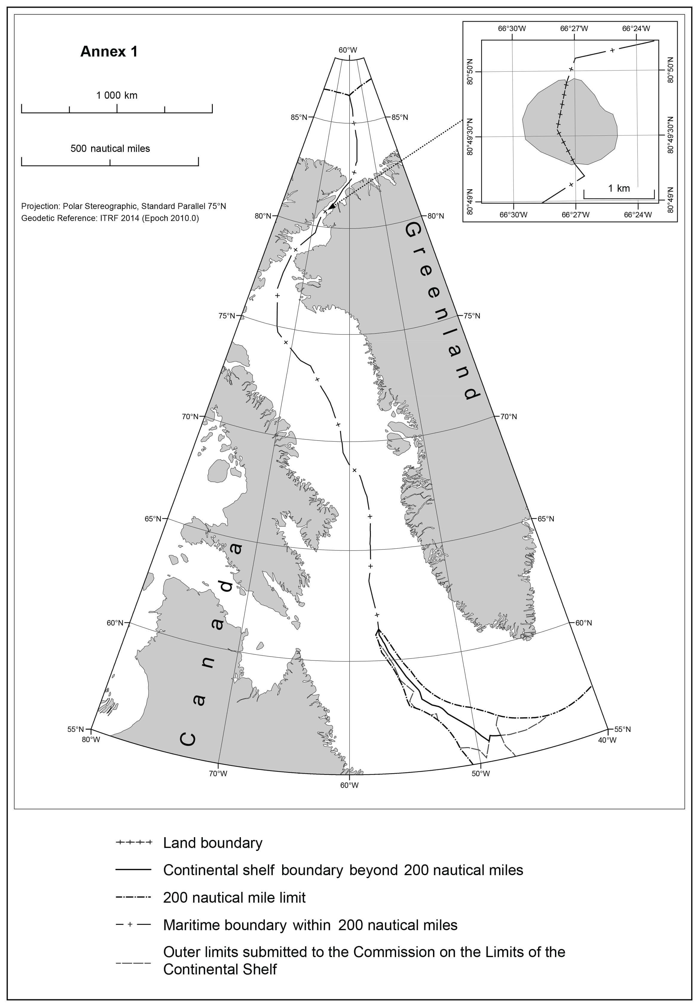
The new agreement between Canada and the Kingdom of Denmark, together with Greenland, resolves the long-standing dispute over sovereignty of Tartupaluk/Hans Island by creating a land boundary. It also modernizes the 1973 boundary within 200 nautical miles and establishes the maritime boundary in the Lincoln Sea. It further establishes a boundary on the continental shelf beyond 200 nautical miles in the Labrador Sea. See the map below.
The maritime boundary within 200 nautical miles, including the Lincoln Sea
In 1973, Canada and the Kingdom of Denmark signed a treaty that established a dividing line in the area between Greenland and Canada as far as, but not including, the Lincoln Sea.
In 2012, a tentative agreement on the maritime boundary in the Lincoln Sea was announced but not finalized. The delimitation line completes the process of technical adjustments to the coordinates of the existing boundary from 1973.
The present agreement incorporates the tentative agreement from 2012 and establishes a modernized single maritime boundary within 200 nautical miles from the Lincoln Sea in the north to the Labrador Sea in the south, which is almost 3,000 km.
Tartupaluk/Hans Island
The island known as Tartupaluk in Greenlandic and Hans Island in English is situated in the Kennedy Channel of Nares Strait between Greenland and Canada. The island is approximately 1.2 km² and is uninhabited and without vegetation or wildlife. However, the island has a traditional, symbolic and historic significance to the local population.
The land boundary on the island follows the natural ravine that runs the length of the island, generally in a direction from north to south.
Continued access to and freedom of movement on the entire island for Inuit and local people living in Avanersuaq, Kalaallit Nunaat, and in Nunavut, Canada, including for hunting, fishing and other related cultural, traditional, historic and future activities, will be maintained. A practical and workable border-implementation regime will be established for all visitors.
Labrador Sea
Canada filed a submission to the Commission on the Limits of the Continental Shelf (CLSC) regarding the outer limits of the continental shelf beyond 200 nautical miles in the Labrador Sea in 2013. The Kingdom of Denmark, together with Greenland, filed its own submission to the CLCS for the same area in 2012.
The submissions revealed an overlapping area of continental shelf, which is a normal part of the scientific process under the United Nations Convention on the Law of the Sea (UNCLOS) to delineate the outer limits of the continental shelf. The agreement establishes a binding boundary line in the overlapping area, which represents an equitable solution consistent with article 83 of UNCLOS.
The map below is for illustrative purposes only.
Page details
- Date modified: