
STATE of ENVIRONMENTAL MONITORING in NORTHERN CANADA
Table of Contents:
Prologue
MARCH 2015
This report is a key Canadian contribution towards the Third International Conference on Arctic Research Planning (ICARP III), a transformative priority-setting exercise that will provide a roadmap to guide researchfocused organizations across the globe in their Arctic research planning and delivery over the next decade. Please visit http://icarp.arcticportal.org/ for more information.
NOTES
In the current analysis, monitoring was defined as at least three years of repeated data collection related to a specific parameter or component of the environment at a given site, or of human health of people belonging to a given sample population or living in a particular community or region, unless noted otherwise. Although shorter-term data were not sought, they were included in the dataset, when provided.
The term ‘parameter’ is used in this report as a general term referring to a variety of words that can describe monitoring variables, including: component, element, measurement, factor, observation.
ACRONYMS
CAFF - Conservation of Arctic Flora and Fauna (CAFF) is an Arctic Council Working Group.
SAON - Sustaining Arctic Observing Networks (SAON) Canada aims to enhance Arctic-wide observing activities by facilitating partnerships and synergies among existing observation and data management activities, and to promote sharing and synthesis of data and information.
CORRESPONDING DATASET
Corresponding data are available on the Sustaining Arctic Observing Networks (SAON) Canada website: http://arcticobservingcanada.ca/state-of-monitoring.html
Message from the Executive Director
The Canadian Polar Commission has a mandate to monitor and report to Canadians on the state of knowledge of the polar regions, and work with Canadian and international institutions to determine scientific and other priorities. In 2014, the Commission released a report on the State of Northern Knowledge in Canada. With a focus on “knowledge to action” research, this report identifies key research gains made since the beginning of International Polar Year and key gaps and opportunities for collaboration in Canada’s North, to address the priorities of Northerners. One of the key gaps identified in this report is the need to further develop, optimize, and coordinate environmental monitoring to provide baseline and trend data that can be used to better understand and manage environmental change and impacts of resource development.
This State of Environmental Monitoring in Northern Canada report provides the fundamental background to support decisions regarding investment in new monitoring sites, and re-deployment and expansion of existing sites to achieve increased coverage of key parameters in priority areas. Based on metadata of atmosphere, cryosphere, freshwater, marine, terrestrial, and human health monitoring projects, the maps in this report geographically indicate what parameters are being measured and where, to identify potential areas of overlap, gaps in coverage, and opportunities for synergies. It is a snapshot of monitoring activities as of December 2014, based on the metadata that was collected. While the current dataset is by no means comprehensive or complete, we will continue to update it going forward, and ensure that it is accessible to others to facilitate further analyses.
In closing, I would like to thank Tara Zamin, Alison Beamish, Nathalie Forget, and Katriina O’Kane from the Association of Polar Early Career Scientists for their hard work to collect and analyze the metadata. I would also like to acknowledge Peter Pulsifer, Research Scientist, National Snow and Ice Data Centre; Warwick Vincent, Scientific Director, Centre d’études nordiques and Professor and Canada Research Chair, Université Laval; and Jill Watkins, Senior Scientific Advisor, Environment and Biodiversity, Fisheries and Oceans Canada for contributing their time and expertise to review this report. Numerous researchers, networks and organizations provided monitoring metadata and assisted in validating the data and analysis. This report would not have been possible without their generous contributions.
Sincerely,
Dr. David J. Scott
Executive Director
Canadian Polar Commission
INTRODUCTION
Environmental monitoring is critical to identifying areas of vulnerability. Repeated and long-term monitoring can assist in understanding the causes and consequences of rapid change and longer-term trends, while supporting safe and sustainable resource development in northern Canada. Canada’s North is vast, with a small population. Consequently, the extent of monitoring in the North is sparse compared to the South. In addition, high operating costs and remote, harsh condi-tions increase challenges associated with establishing monitoring infrastructure and ensuring sufficient geographic coverage of the North. Increased coordination efforts would enhance the efficiency and effec-tiveness of monitoring in northern Canada, as well as help to address gaps in spatial coverage.
Significant investment in monitoring has been made by federal and territorial gov-ernments, academia, non-governmental organizations, industry, and communities. While the coordinating efforts of Sustaining Arctic Observing Networks (SAON) Canada have assisted in bringing many ongoing monitoring programs under a single umbrella, there is potential to further link existing networks through improved coordination. In support of SAON Canada and the broader Arctic monitoring community, the Canadian Polar Commis-sion (CPC) has collected information and reviewed monitoring in the Canadian North. This report aims to provide a better under-standing of the current state of environ-mental monitoring in northern Canada, by geographically indicating what parameters are being measured and where. This information can then be used to identify opportunities for collaboration, to improve the level of coordination of current moni- toring initiatives, and identify areas where new investment could provide the greatest impact.
html Information was collected from the Canadian Arctic monitoring community, including federal and territorial govern- ments, non-governmental organizations, academia, and industry. Both natural science and human health monitoring (including physical and mental health) initiatives were included under the follow- ing thematic monitoring areas that are currently encompassed by the SAON umbrella: atmosphere; cryosphere; freshwater; marine; terrestrial; and human health.
Collection efforts were directed towards the largest monitoring programs and networks for a given thematic area, such as Environment Canada weather stations, the Arctic Development and Adaptation to Permafrost in Transition (ADAPT) network, and the Circumpolar Biodiversity Monitoring Program (CBMP). Monitoring locations are mapped in order to explore geographical gaps by thematic areas. A list of all programs identified through this inventory is available as a separate document.
It is fully recognized and acknowledged that the current dataset is not compre- hensive or complete. Numerous programs exist for which the full suite of metadata has not yet been acquired, and which therefore have not been reflected in this review. For example, locally based, small- scale monitoring initiatives were more challenging to incorporate into this type of collection exercise and as such, some may not be represented in the data. Traditional ecological knowledge initiatives are also not represented in the data. However, initiatives are underway to better capture community-based monitoring and traditional knowledge in the Canadian Arctic.
By capturing the largest and most wide- spread networks of monitoring in northern Canada, this analysis represents an indication of where substantial investments have been focused over the past decade.
A key output from this work is an “evergreen” database of monitoring activities in northern Canada. The opportunity to correlate this with other data can provide value-added information for an infinite number of uses.
This analysis provides a foundation for informing current and future monitoring initiatives, as well as groundwork for the development of cumulative impacts report- ing and assessments. The results and recommendations provide a high-level analysis of themed monitoring parameters, spatially represented over the Canadian North. With extensive northern monitoring activities operated by various organizations, there is an opportunity to increase coordi- nation, link networks and collectively identify areas of priority that require enhanced monitoring. Areas of importance could result from potential resource development, increased environmental sensitivity and areas of importance to Northerners for culture or subsistence harvesting. Information regarding the geographic focus of current monitoring initiatives, compared to areas of importance, provides evidence to support decision- making and policy development to address gaps and priority areas for northern monitoring activities.
Note: This report provides a summary of the monitoring metadata collected and results from the subsequent analysis that was undertaken. The complete dataset is available on the SAON Canada website:
METHODOLOGY
Definitions and boundaries
The collection area for northern monitoring information was broadly defined as the Canadian International Polar Year (IPY) Study Area, which included all areas north of the southern limit of discontinuous permafrost, as defined at the time of IPY in 2007/2008. This includes the northern- most areas of all provinces, excluding the maritime provinces.
The maps included in this report, however, only include points for a subset of this region, i.e., the area delineated by the Arctic Council’s Conservation of Arctic Flora and Fauna (CAFF) Working Group. The CAFF boundary is depicted on each of the maps in this report as a thin black line. This boundary was used in the gap analysis because it was consistent with the regional delineation used by the Circumpolar Biodiversity Monitoring Program (CBMP), which was an important source of data in this analysis. The entire dataset is available on the Sustaining Arctic Observing Networks (SAON) Canada website: http://arcticobservingcanada.ca/state-of-monitoring.html

Boundary and the International Polar Year (IPY) 2007/2008 Study Area
In the current analysis, monitoring was defined as at least three years of repeated data collection related to a specific parameter or component of the environment at a given site, or of human health of people belonging to a given sample population or living in a particular community or region, unless noted otherwise. Although short- er-term data were not sought, they were included in the dataset, when provided. Project durations are delineated in the maps, and exact start and end dates (where available) are included in the full dataset on the website. Lastly, the temporal focus was on the period from 2000 to 2014, in order to assess the current state of monitoring, although older data were acquired when available and are clearly depicted in the maps.
Data collection
Monitoring projects were identified using the following methods:
- Contacting all project leaders within the SAON Canada Inventory (2013), including 30 projects explicitly under SAON Canada, and 36 projects with known monitoring information. SAON Canada includes primarily federal and territorial monitoring projects;
- Working with the Circumpolar Biodiversity Monitoring Program (CBMP) Marine, Freshwater, and Terrestrial Canadian steering group contacts, files, and recommendations;
- Contacting the program managers for the Canadian Network of Northern Research Operators (CNNRO) regarding monitoring conducted at northern research stations;
- Contacting industry representatives and acquiring publicly available monitoring reports for projects included in the Natural Resource Development and Infrastructure Projects list developed by the Canadian Northern Economic Development Agency (Canadian Northern Economic Development Agency, 2013);
- Recommendations for follow-up with other groups;
- Searching databases of Arctic project metadata, including from the Polar Data Catalogue (PDC); and,
- Identifying leads on specific topics via targeted online search of northern organizations and institutions
For each project, the following metadata fields were collected, with information as complete as possible for any given entry:
Background information:
|
Responsible parties:
|
Spatial information:
|
Data collection methods:
|
Temporal information:
|
Data availability:
|
Parameters monitored:
|
A preliminary analysis was conducted based on the initial collection of monitoring metadata and sent out for expert review. The metadata and corresponding maps and analysis were reviewed and validated by 34 individuals or organizations involved in monitoring in northern Canada. All updates to the datasets and analysis have been implemented as of December 2014, and are reflected in the final maps below.
Data analysis
The analysis and resulting maps were generated using two main parameters: geographical information and thematic information (e.g., atmosphere). For geographical information, the latitude and longitude coordinates for the monitoring sites or polygons for broader sampling areas were collected when possible. In some cases, this detailed information was not available, either because new sites are visited annually to monitor the same parameter (e.g., caribou monitoring), or because privacy concerns prohibit sitespecific reporting (e.g., human health monitoring). The compiled dataset includes all projects—those represented on the maps and those which are not graphically displayed.
In order to guide the thematic analysis, each monitoring project was tagged with relevant keywords by CPC analysts and/or project leaders. These keywords (see list below) were intended to represent the parameters of greatest interest in any given thematic area. Instead of having biodiversity as a separate monitoring theme, organisms were categorized under the freshwater, marine, or terrestrial monitoring themes. The dataset was then queried by keyword, and the resulting project entries were mapped.
Parameters analyzed under each monitoring theme include the following:
Atmospheric
|
Cryosphere
|
Freshwater
|
Marine
|
Terrestrial
|
Human Health
|
| (*includes terrestrial, freshwater and marine biogeochemical monitoring) | ||
Maps were created for each of the parameters. In mapping the data, the CAFF boundary was chosen as the delimitation area since this was consistent with the biodiversity data that comprised about half of the analysis. The CAFF boundary is more conservative than the International Polar Year (IPY) Canada delimitation in the Yukon, northern British Columbia, Saskatchewan, and Manitoba, and more liberal in the area around James Bay, northern Quebec and Labrador. As such, not all of the metadata compiled are depicted on the maps in this report. The dataset contains all data collected, regardless of the date, region or duration of the initiative.
Maps were analyzed by visual inspection to identify gaps in geographic coverage of a monitoring parameter. A gap was defined as lack of of reported monitoring activity in a geographic area or for a monitoring parameter, when compared to other geographic areas for that parameter. When identifying geographic gaps, consideration was also given to the presence of communities and areas that may experience change due to resource development. The background evidence was based primarily on information from an analysis of notional mineral and energy projects, with marine shipping routes of interest that was undertaken by Natural Resources Canada, Aboriginal Affairs and Northern Development Canada, and the Canadian Northern Economic Development Agency (CanNor). The information obtained from the interdepartmental review was used to validate the regions, not solely to identify areas and exclude others. The information is not publicly available at this time, however CanNor has published a map indicating natural resource development projects in the North (Canadian Northern Economic Development Agency, 2013). Reports identifying resource development projects proposed for Canada’s North (e.g., Gavrilchuk & Lesage, 2014) and key marine shipping routes (e.g., The Mariport Group, 2007; Protection of the Arctic Marine Environment, 2009) are also available.
This is one possible methodology of many to identify significant gaps based on human presence and resource development activities in the Arctic. As previously mentioned, the dataset that is available on the SAON Canada website contains all the metadata collected and can be used to perform further analyses. Consideration of the specific needs of potential users of monitoring and areas of the North that are ecologically and biologically significant were outside the scope of this analysis, as well as evaluation of the quality of individual monitoring initiatives.
Interpretation of maps that follow:
In the maps that follow, sites are delineated based on duration of monitoring. Where project start and/or end dates were not available, the sites are mapped as ‘unavailable duration’. The CAFF boundary is represented as a thin black line.
Several maps contain shaded polygons. These include terrestrial bird monitoring and all human health monitoring. In the case of terrestrial bird monitoring, polygons are used to indicate larger sampling areas that extend beyond a single monitoring site. In the case of human health monitoring, all provinces and territories are shaded to indicate that there is data available at the provincial and territorial level, rather than at the community/site level.
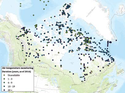
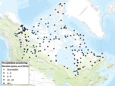
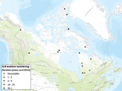
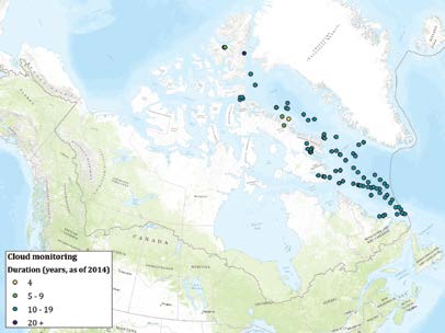
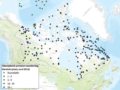
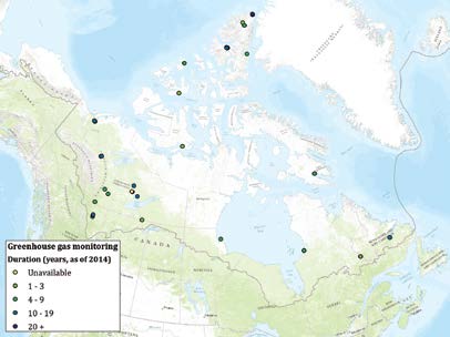
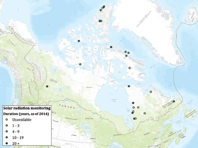
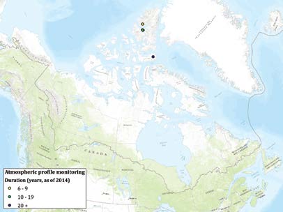
Atmospheric Monitoring
Environment Canada is the main organization conducting atmospheric monitoring in northern Canada. Its Surface Weather Network is the most extensive longterm monitoring network. Regular visits ensure the weather stations are functioning and calibration of the instruments ensure the quality of the data. Centre d’études nordiques is also a significant contributor to northern climate parameters, including air temperature, precipitation and soil temperature throughout Nunavut, Nunavik and Nunatsiavut.
Geographic gaps in precipitation monitoring exist in the northern archipelago, as well as inland areas of the NWT, Nunavut, and Nunavik. Solar radiation, which was identified as a parameter of importance (Arctic Climate Impact Assessment, 2004) is not well monitored across the North. Soil moisture and soil temperature, which are not monitored extensively in the High Arctic, will increasingly become key parameters, as temperatures increase and permafrost warms. Given the extensive network for other atmospheric parameters, there is an opportunity to enhance monitoring by leveraging infrastructure and collaborating on maintenance.
|
|

|
|

|
|
|

|
|
|

|
|
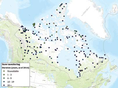
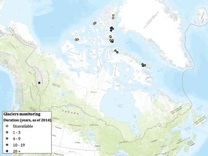
Cryospheric Monitoring

A wide range of organizations, including federal and territorial governments and academia, conduct cryospheric monitoring. Permafrost monitoring is fairly comprehensive along the Mackenzie River and Delta, which is a major transportation/transmission corridor. As well, there is broad coverage of both permafrost and snow-related monitoring in the communities of Nunavik.
There are notable gaps in permafrost monitoring in the region north of Great Slave Lake and around Bathurst Inlet, where there may be high resource development potential and the need for more infrastructure development. There is a need for increased monitoring of permafrost in and around communities, to inform adaptive building practices and regulations and to monitor infrastructure stability. Opportunities for collaboration with resource development companies could be explored to increase permafrost monitoring in some underrepresented areas. For example, collaboration with a mining company could enable the installation of instrumentation for permafrost monitoring in boreholes that have already been or will be drilled for geotechnical studies.
There is limited information on snow-related parameters near communities, as it relates to water levels in lakes and rivers and corresponding impacts on flora and fauna. The extent of snow cover and timing of melt are key inputs into climate models, which remote sensing can efficiently address. Many cryospheric monitoring programs are using remote sensing data in snow, ice and glacier monitoring. Remote sensing monitoring programs were not reflected in this analysis, and therefore the gaps identified in this report may be less critical than identified. However, in-situ measurements are required to reconcile remotely sensed measurements, and therefore are required throughout the North. Increased in-situ monitoring of snow in the southern and western Arctic Archipelago could enable enhanced understanding of regional drivers of change.
Ongoing monitoring of the Barnes Ice Cap and the Penny Ice Cap is needed in order to more fully understand how mass balance is changing across the North. Potential new sites for glacier monitoring could include areas along Western Ellesmere Island, Axel Heiberg Island, and along the central eastern coast of Baffin Island, as they have also been identified as areas of importance.

|
|
|

|
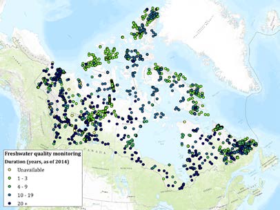
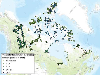
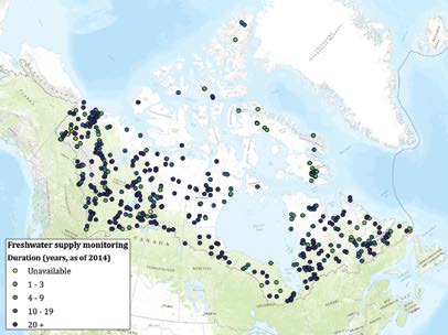
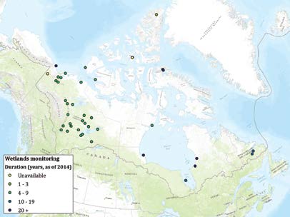
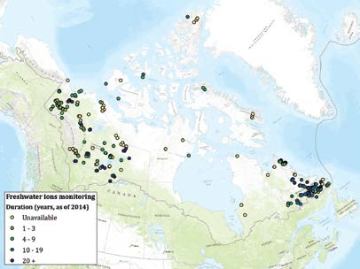
Freshwater Monitoring
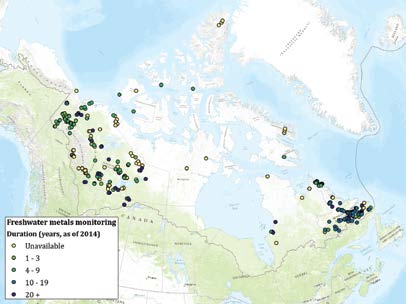
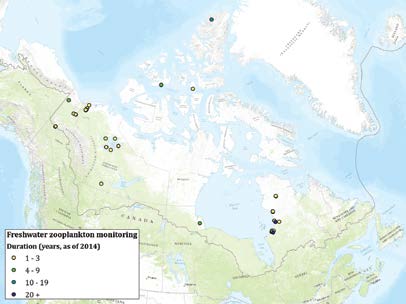
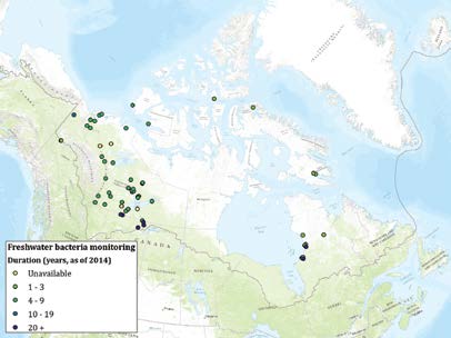
There are numerous institutions that conduct freshwater monitoring in Canada’s North, with the most extensive network being Environment Canada’s Hydrometric Data (HYDAT) network, which is used to monitor water levels and stream flows. Environment Canada also contributes to monitoring water quality, water chemistry, and wastewater. Fisheries and Oceans Canada plays an active role in monitoring fish throughout the Canadian Arctic, as do several communities under community-based monitoring programs.
With respect to geographic coverage, there is limited freshwater monitoring in the Arctic Archipelago, including northern Baffin Island where there is significant potential for resource development. Gaps have been identified for freshwater quality monitoring in the Arctic Archipelago, mainland Nunavut, and Nunavik. There is poor coverage of freshwater ice and river monitoring, most notably in the NWT and Nunavut. Wetlands monitoring is sparse along the southern coast of Hudson Bay where there is an abundance of wetlands. This may result from a lack of reporting when referring to wetlands monitoring as this is often accounted for in lakes and river monitoring programs.
More intensive monitoring of freshwater quality is needed in areas close to communities and around resource development, such as northern Baffin Island. Freshwater monitoring programs similar to Environment Canada’s HYDAT network would benefit areas of the Archipelago, mainland Nunavut and Nunavik.
Further development of community monitoring networks can assist in increasing geographic coverage of monitoring, while reducing travel expenses, encouraging community engagement, and enhancing skills development and training, with limited additional effort. This includes community-based harvester monitoring programs aimed at providing information and samples to researchers to address community-identified issues.
Maps with many green points (i.e., monitoring activities with a duration of one to three years) are populated with completed projects that were compiled by the Circumpolar Biodiversity Monitoring Program. Most of these are one-time sampling events that do not monitor lake systems for a long period of time. They do, however, capture a very large footprint of baseline data across a large geographic range.
|

|
| *Note: Freshwater quality includes monitoring initiatives that can assist in assessing the quality of freshwater. Maps are also available for more specific freshwater quality parameters (e.g., bacteria, metals) for those monitoring initiatives where more in depth metadata were available. |
|
|
|

|

|

|
|

|

|
|
|

|

|

|

|
|

|
|
|
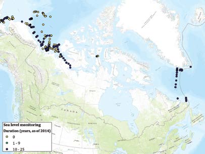
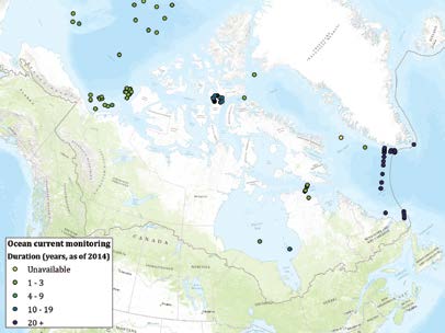
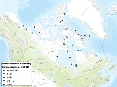
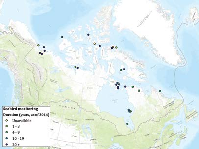
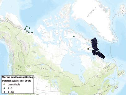
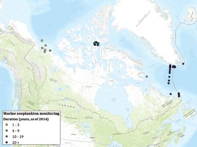
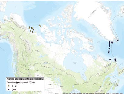
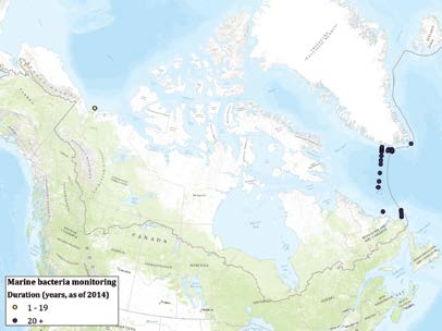
Marine Monitoring
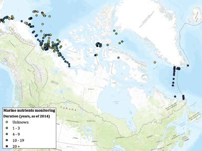
Some of the key organizations involved in marine monitoring are federal government departments and academia, including Fisheries and Oceans Canada, University of Manitoba, and Université Laval. Most marine parameters have fairly comprehensive monitoring coverage in the Beaufort Sea, primarily as a result of projects conducted as part of the Beaufort Regional Environmental Assessment.
Key marine monitoring gaps exist in the Northwest Passage, from Dease Strait to the north end of Peel Sound, and in the northern Arctic Archipelago. There is also a need to increase monitoring of marine abiotic and biotic parameters in the Hudson Bay, given that the Port of Churchill is a key international Arctic seaport. Increased sea ice monitoring is needed in straits that are shipping routes. Increased monitoring of marine mammals along the east coast of Baffin Island in Baffin Bay is also needed. In general, there are gaps in marine monitoring in Foxe Basin, and on the western side of the Arctic Archipelago. Priority areas of focus would be those that are located near coastal communities.
|
|
|
|
|
|
|
|
|
|

|
|
|
|
|

|
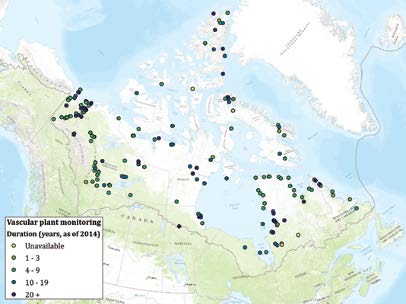
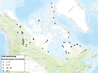
Terrestrial Monitoring
For the terrestrial monitoring parameters included in this study, key organizations involved in longer-term monitoring include Environment Canada, Université du Québec à Trois-Rivières, Université Laval, and the territorial governments. The main spatial research gaps are present in the western Arctic Archipelago and northern Ellesmere Island. There are also spatial gaps in mainland NWT and Nunavut within areas of potential resource development activity. Gaps in long-term monitoring of soil physical and chemical properties also exist.
Limited spatial coverage of tundra flora monitoring is found in the western Archipelago and High Arctic. Adequate coverage of tundra flora monitoring exists in areas of potential mineral resource development, but there is limited coverage in areas of potential energy development. An increase in monitoring is suggested for tundra ecosystem parameters, including long-term monitoring of soil, arthropods, bacteria and nutrients in general across the Canadian Arctic. There is also a need to increase monitoring of important bird habitat near potential areas of high resource development potential. A noticeable gap in terrestrial monitoring is in the southern mainland of Nunavut, west of Hudson Bay. Although most of these parameters do not have comprehensive coverage across the North, possibly due to the low bio-productivity of terrestrial elements in the Arctic, this will change as temperatures increase.
There is an opportunity for greater collaboration between organizations conducting aerial surveys of components of the terrestrial environment (mammals, birds, etc.) during routine site visits or infrastructure maintenance stops. The existing infrastructure could be leveraged to monitor additional parameters. For example, camera traps (i.e., remotely activated cameras) could be installed at existing monitoring sites to capture photographs of wildlife and vegetation. In addition, increased sharing and access to baseline vegetation data regarding tundra flora among organizations would be beneficial.

|

|

|
|

|

|
|

|
*Biogeochemistry (*includes terrestrial, freshwater and marine biogeochemical monitoring)
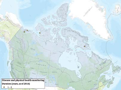
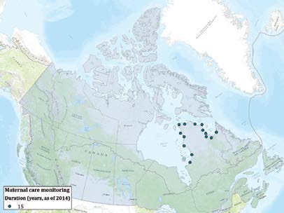
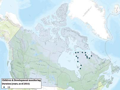
Human Health Monitoring
Human health monitoring initiatives, including those related to physical and mental health, are occurring at the territorial, provincial, and regional level in Canada’s North, and are more recently being established at the community level. Major programs for ongoing human health monitoring include the International Circumpolar Surveillance (ICS) initiative, Circumpolar Health Observatory (CircHOB), and some long-term monitoring projects under the Northern Contaminants Program. Statistics Canada also provides ongoing health monitoring through the Aboriginal Peoples Survey that is conducted every 5 years, and the Canadian Community Health Survey that is conducted annually, which includes the largest communities in the North.
Monitoring gaps may occur in the case of emerging health concerns that could fall outside the scope of existing networks, which tend to focus on monitoring specific conditions such as tuberculosis or invasive bacterial diseases. There is a need to ensure that monitoring programs with broad thematic coverage are flexible and responsive to emerging diseases and other health issues (such as sexually transmitted and blood-borne infections and antibiotic or antiviral resistant organisms).
There is a need to conduct thorough analyses at regular intervals regarding mental health status, community support systems, and the broader socioeconomic context for communities across the North. Mental health has been continuously identified as a critical issue for Northerners, as it relates to individual health and the well-being and resilience of communities. It is difficult to determine the full extent of mental health monitoring in the absence of more community-level data. Between the Inuit Health Survey of the Nunatsiavut, Inuvialuit, and Nunavut regions (2008) and the Nunavik Inuit Health Survey (2004), there appears to have been a relatively thorough assessment of mental health across these particular regions. A second edition of the Nunavik Inuit Health Survey is planned for 2016. With the other assessments having been conducted approximately 7 years ago, reassessments would be timely, particularly in light of increasing change in the North. While the Aboriginal Peoples Survey of Statistics Canada that occurs every 5 years could assist in addressing these gaps to a certain extent, the data collected provides less detail.
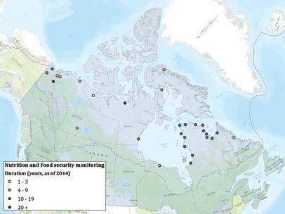
Monitoring of contaminants in marine mammals, caribou, seabirds, and fishes occurs across the North primarily through projects funded under the Northern Contaminants Program, and link directly to human health given that they are traditional food sources for many northern communities. Using the community-based monitoring model of the NWT, there is an opportunity to create community-based water and wildlife contaminants monitoring in priority communities across the Yukon, Nunavut, Nunavik, and Nunatsiavut.
Increased community-based monitoring of food security, nutrition, and contaminants levels is needed, particularly for communities in the NWT and Nunavut. There is an opportunity for information and data sharing among food security monitoring initiatives that are undertaken at various levels (territorial, provincial, regional or community) to assist in situating community-level data in a broader context. This would enhance the coverage and provide a better understanding of the drivers of food security issues, and also to provide greater community-level understanding of more regional, territorial, or provincial-level data.
The maps provide a visual representation of the extent and geographic coverage of monitoring for each human health parameter. Most human health monitoring data are reported at the provincial, territorial, or regional level. Due to privacy restrictions and small sample sizes, it is difficult to ascertain gaps in geographical coverage. Regions are, therefore, shaded in the maps that follow in order to represent the presence of data for a given parameter or component.
|
|

|
|

|
|
| *For contaminants monitoring, regional-level data are available for Nunavik, rather than for all of Quebec as indicated in the shading. |
|
CONCLUDING COMMENTS
Monitoring and multidisciplinary analysis is critical to improving our understanding of the causes and consequences of rapid environmental change in northern Canada and to facilitate adaptation. The metadata collected for this report and the subsequent analysis demonstrate that while there is substantial monitoring in Canada’s North, gaps in coverage are present for a number of key parameters and components in the areas of atmospheric, cryospheric, freshwater, marine, terrestrial, and human health monitoring that are important in the context of resource development and climate change. Another concern is the short-term duration of many monitoring programs. Baseline information is fundamental in any analysis, and detecting change requires long-term monitoring, with the required duration and frequency dependent on the parameter.
Environmental monitoring is carried out by numerous individuals and institutions, including federal, territorial and regional governments, academia, and non-governmental organizations that have a wide variety of mandates. Institutions can examine the metadata associated with this analysis against their own mandates to assist in identifying potential areas of overlap, gaps in coverage, and opportunities for synergies. The analysis provides the fundamental background to support decisions regarding investment in new sites, re-deployment and expansion of existing sites to achieve increased coverage of key parameters in priority areas.
Current monitoring efforts in the North could benefit from greater coordination and collaboration, both logistically and operationally, in support of longer-term planning and strategic direction. Significant benefits can result from linking field campaigns and ensuring data is interoperable and accessible. Increased engagement, involvement, and more importantly empowerment of northern communities is also critical, especially in terms of increasing monitoring coverage and promoting sustained monitoring over the long term. Greater consideration of the needs of potential users of the monitoring data such as northern communities, policymakers, and resource managers and developers, would ensure that monitoring addresses areas of priority for Northerners, working with Northerners. Focusing on areas of the North that are ecologically and biologically significant is important when identifying priority areas and monitoring parameters that warrant increased strategic investment, coordination or collaboration.
Although private sector resource development companies have a wealth of monitoring data, collected in accordance with regulatory requirements, metadata from industry was not a large part of this study, given that it was not readily available or accessible. Effort should be directed to enhance partnerships and collaboration with industry to enhance understanding of the changing environment in and around resource development regions.
Key gaps in monitoring coverage
A number of key monitoring gaps were identified that are important with respect to geographic coverage, climate change and resource development activities. Monitoring gaps pertaining to the specific needs of potential users of monitoring and areas of the North that are ecologically and biologically significant were outside the scope of this analysis, along with an evaluation of the quality of individual monitoring initiatives.
Limited monitoring of most parameters/components in the western Arctic Archipelago requires increased investments to provide more comprehensive and representative coverage of key variables. Increased monitoring is needed in areas where there is, or is anticipated to be, increased shipping traffic. For example, although the Port of Churchill is a key international Arctic seaport, there is a lack of marine monitoring in Hudson Bay. Areas with the highest potential for resource development require baseline information based on the vulnerability and sensitivity of the region and the significance of the region for people and wildlife. For example, in areas around Bathurst Inlet, Chesterfield Inlet and northern Baffin Island, there is a need for increased monitoring to provide baseline terrestrial and freshwater information. Data from remote sensing could assist in increasing monitoring coverage in underrepresented areas for certain parameters such as those that pertain to the cryosphere, with supporting in-situ measurements collected through communitybased monitoring programs. Coupling of ground- or sea-level monitoring with remote sensing platforms including satellites and unmanned aerial vehicles can also assist in providing greater monitoring coverage. Certain parameters will become increasingly important as climate change alters the northern landscape and activity increases in the North. Baseline monitoring for terrestrial and cryosphere parameters, as well as pollutants will help to provide evidence of change and areas where change is most rapid.
The current analysis focused on the period from 2000 to 2014. There is an opportunity to explore the usefulness of re-sampling at former sites that were used for monitoring before this period. Data from re-sampling at these sites could be used to build on previous data that have been collected to assist in establishing some historical baselines.
Data policies and management
Monitoring data and metadata are stored in a variety of structures, some more accessible and sharable than others. Organizations are becoming more aware of the need to maintain standards in data collection and storage, so that it is usable by others. Standardized data management policies can assist in enhancing interoperability of data across disciplines, while standardized metadata can facilitate the accessibility of data and enable the compilation of various datasets. As organizations plan monitoring activities, adherence to standard data practices would enhance interoperability of the information, especially if incorporated into a data management plan. Where standardization is not feasible, investments in data translation through emerging brokering techniques may provide a cost effective method for making data interoperable.
Opportunities for collaboration
Current monitoring efforts in the North could benefit from greater coordination and collaboration to optimize the use of infrastructure, resources, travel and logistics, as well as greater alignment of strategic direction. This can maximize the benefit of monitoring efforts and resources, as it is expensive and challenging to operate in the North. Some opportunities for collaboration include:
- Maintenance of existing monitoring initiatives in areas of high priority to ensure continued effectiveness and sustainability;
- Upgrades to existing monitoring sites by incorporating additional sensors to enable monitoring of increased parameters;
- Collection of additional monitoring data at or near existing sites including during, and/or en route to, site and equipment maintenance trips;
- Cross-disciplinary, integrated monitoring to better understand complex feedbacks and processes;
- Expansion of existing community-based monitoring programs to include other parameters and components of relevance to community well-being, adaptation and environmental change; and,
- Implementation of new community-based monitoring programs that build on the success of previous initiatives, especially in areas where there is resource development potential or areas that are ecologically or culturally significant.
Opportunities for collaboration with industry, academia, non-governmental organizations, as well as international researchers and institutions should be sought.
REFERENCES
Arctic Climate Impact Assessment. (2004). Impacts of a Warming Arctic: Arctic Climate Impact Assessment. Cambridge University Press. Available at: www.acia.uaf.edu/
Atlas of Community-Based Monitoring and Traditional Knowledge in a Changing Arctic. (n.d.). About the Atlas. Atlas of Community-Based Monitoring and Traditional Knowledge in a Changing Arctic. Available at: http://www.arcticcbm.org/index.html
Canadian Northern Economic Development Agency. (2013). Natural Resource Development and Infrastructure Projects in the North. Canadian Northern Economic Development Agency, Government of Canada. Available at: www.cannor.gc.ca/eng/1386004855342/1386004881540
Gavrilchuk, K. and Lesage, V. (2014). Large-Scale Marine Development Projects (Mineral, Oil and Gas, Infrastructure) Proposed for Canada’s North. Canadian Technical Report of Fisheries and Aquatic Sciences 3069. Mont-Joli, QC: Science Branch, Fisheries and Oceans Canada. Retrieved from http://publications.gc.ca/collections/collection_2014/mpo-dfo/Fs97-6-3069-eng.pdf
Protection of the Arctic Marine Environment. (2009). Arctic Council Arctic Marine Shipping Assessment 2009 Report. Retrieved from http://www.pame.is/images/03_Projects/AMSA/AMSA_2009_report/AMSA_2009_Report_2nd_print.pdf
Sustaining Arctic Observing Networks Canada. (2013). Inventory of Arctic Observing Networks Canada- 2013 Update. Sustaining Arctic Observing Networks, 105 pp. Available at: http://arcticobservingcanada.ca/SAON-documents-english.html
The Mariport Group. (2007). Canadian Arctic Shipping Assessment. Main Report. Prepared for Transport Canada. Digby, NS: The Mariport Group.
For a full list of project references, please see the full dataset, available on the SAON Canada website: http://arcticobservingcanada.ca/state-of-monitoring.html.