
Sophisticated system supports species at risk
Wildlife preservation is a significant challenge, but we now have more ways than ever to meet it successfully, through legislation, expertise and new technological solutions.
The Species at Risk Act was passed in 2002 to prevent our wildlife species from becoming extinct, by mandating support and recovery activities. In accordance with the act, the Government of Canada is taking steps to manage and protect wildlife and natural habitats found on federal properties.
With an extensive real estate portfolio, Public Services and Procurement Canada (PSPC) has a vital role to play in this conservation effort, and we're using technology to advance our work.
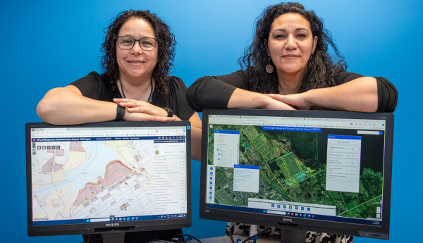
In collaboration with an internal species at risk (SAR) network, 2 women from our department put their heads and unique skill sets together to develop a SAR mapping tool using a geographic information system. The mapping tool is a game-changer when it comes to tracking and conserving biological diversity at federal sites in the National Capital Region managed by PSPC.
A customized approach
Tracking protected species on PSPC properties used to be a task almost as untamed as the creatures themselves. "The information was scattered across file folders containing various reports and spreadsheets," explains Senior Environmental Specialist, Fatma Boujenoui. "When I was asked to provide data on the presence of a certain species or wildlife habitat to a property manager or a project team starting work at a facility, it took quite a search. It wasn't practical."
Boujenoui approached Isabelle Proulx, a specialist in geographic information systems, about creating a mapping tool to store our SAR data and visually represent all the species and their habitats on properties managed by PSPC in the National Capital Region. The work to develop this tool was completed exclusively within PSPC, using our environmental and geographic expertise. With the addition of data provided by federal and provincial partners, the Species at Risk Information System was born.

Over several years, Proulx and Boujenoui added unique functionality and details, including a tree inventory, turning the mapping tool into a comprehensive and versatile resource. "It contains multiple layers of data," says Proulx. "Beyond the coordinates and habitat records for hundreds of protected species, there are links to other official sources, legal acts, reports, property features, and much more. There are also many filter and query options."
The tool is not only customized for properties PSPC owns or operates on behalf of other federal organizations; it's rooted in a specific PSPC protocol that ranks our sites based on the probability that they host SAR and lays out related protection measures. "With this tool, I can easily access all the site rankings and ensure we're following our protocol," says Boujenoui.
More than a map
"This tool is a powerful vehicle for research and analysis," Boujenoui points out. "I can see the biodiversity and habitats present at our assets throughout the National Capital Region. I can focus on a species and find it geographically represented on a map, based on where it has been observed or ‘sighted.' That picture is worth 1,000 words. Combined with all the related information about the species, it really describes the situation on the ground, enhancing our ability to support SAR at our sites."
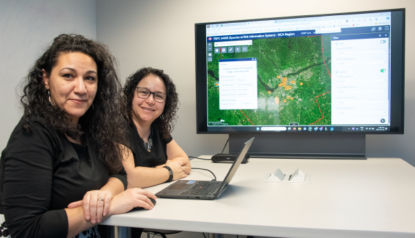
The analysis enabled by the tool also helps identify gaps in knowledge and maximize limited resources. As Proulx explains, "If PSPC has a budget to conduct SAR studies at our assets, we can use this internal tool to determine which locations need it most and how to spend the funds efficiently." PSPC isn't the only organization to benefit. The mapping tool supports better planning, decision-making and species conservation tactics on a large scale, as the information and insights can be shared with other stakeholders, like the city, when working on joint projects.
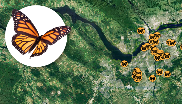
There's no better way to illustrate the value of the tool than by looking at the case of the monarch butterfly. The species was recently upgraded from Special Concern to Endangered status. "That has implications for some of our properties," says Boujenoui. "Since I can now see on a map the distribution of this species at our sites around the region and how many sightings there were at each, I know who to contact at PSPC and in partner organizations to discuss the impacts. For example, there may be a need to obtain a permit for certain types of projects."
The development of the tool has led to positive changes both in how PSPC approaches SAR work and prospects for future progress. "Many groups in the department collect SAR data for projects. To ensure consistent data collection that is easily integrated into the tool, we created specific geospatial data submission requirements," says Boujenoui. "This is key to our understanding of the biodiversity at our sites and brings us closer to our goal of rolling out this tool to PSPC teams in other regions, to enhance our species conservation efforts across Canada."
See Our stories to read more articles about interesting PSPC people and projects.